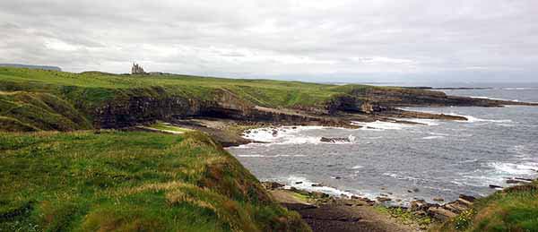
DONEGAL & THE NORTHWEST
County Donegal, the northernmost part of the island, is about as far-flung as Ireland gets—and it wears its isolation well. It’s not on the way to anywhere, though it’s an easy side-trip from Derry. With more native Irish speakers than in any other county, the old ways are better preserved here.
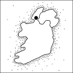
Donegal is connected to the Republic by a slim, five-mile-wide umbilical cord of land on its southwest coast. A forgotten economic backwater (part of the Republic but riding piggyback on Northern Ireland), it lacks blockbuster museums or sights, and its appeal is subtle. But it’s also Ireland’s second-biggest county, with a wide-open “big sky” interior and 200 miles of shattered-glass, jagged coast, chock-a-block with islands, inlets, coves, and shimmering beaches. A visit here is about the journey, and adventurous drivers will be rewarded with a peek into old Irish ways and pleasing scenery.
PLANNING YOUR TIME
Without a car, I’d skip this area; public transportation is scarce.
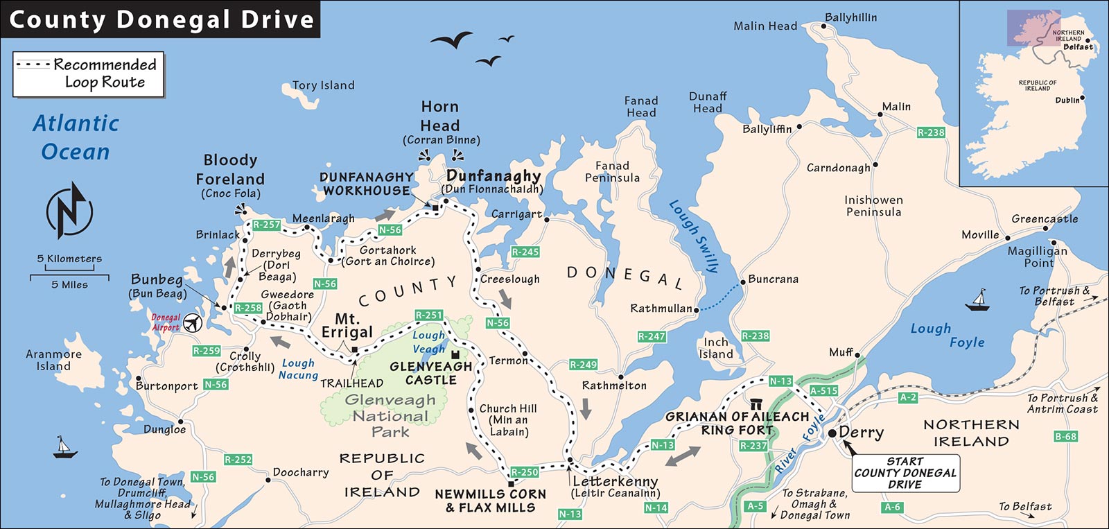
Day Trip from Derry: The ideal way to see Donegal is as a day trip from the Northern Ireland town of Derry. For drivers wanting to explore the region fully, I’ve laid out a day-trip loop through the northernmost reaches of County Donegal (starting and ending in Derry, and best for people home-basing there).
Connecting with the South: Drivers connecting the Republic (Galway or Westport) and Northern Ireland without time for a Donegal deep dive can easily hit several interesting sights en route, including a swing through a swath of County Donegal and the town of the same name, with a worthwhile reconstructed castle.
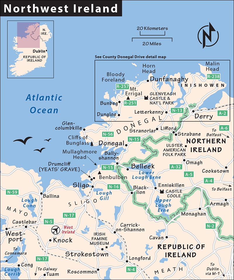
While it might be tempting to do the full trip from Galway to Derry in a single day, there’s a lot to see. Consider overnighting in Westport, which gives you more time to enjoy the Connemara scenery (see that chapter) and to savor the delightful town of Westport itself.
County Donegal Drive
This ambitious daylong driving circuit offers a scenic mix of Donegal highlands and coastal views. Remember, Derry is part of the UK (pounds, miles); Donegal is the Republic (euros, kilometers).
PLANNING YOUR DRIVE
The total drive is about 150 miles (240 km). Allow about four hours of drive time, plus sightseeing stops. Here’s a suggested schedule for maximum sightseeing:
This schedule assumes you’re not climbing Mount Errigal or doing a lot of hiking at Glenveagh National Park. If you do, consider skipping something or spending the night (best in Dunfanaghy).
Driving Tips: The narrow roads along this route are full of curves and bumps. Dogs, bred to herd sheep, dart from side lanes to practice their bluffing techniques. You’ll be lucky to average 65 kilometers per hour (about 40 mph) over the course of the day. It’s cheapest to top off your gas tank in Letterkenny.
Other Tips: Consider bringing a picnic lunch to enjoy at Glenveagh National Park, at a scenic roadside pullout along the Bloody Foreland, or out on Horn Head. If you’re hoping to climb Mount Errigal, check the forecast and get route tips at the TIs in Derry or Letterkenny.
Donegal Loop from Derry
DERRY TO GLENVEAGH
• Drive west out of Derry (direction: Letterkenny) on Buncrana Road, which becomes A-2. This becomes N-13 across the border in the Republic, near the town of Bridge End.
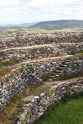
You’ll see a sign for the Grianan of Aileach Ring Fort posted on N-13, not far from the junction with R-239. Turn up the steep hill at the modern church with the round roof, and follow signs 2 miles (3 km) up the hill. (You could also save the ring fort for the end of the day—you’ll pass by here again on your way back to Derry. If the morning is socked-in, but sun is forecast for later, skip it for now.)
▲Grianan of Aileach Ring Fort
This dramatic, ancient ring fort perches on an 800-foot hill just inside the Republic, a stone’s throw from Derry. Of Ireland’s countless ring forts, this is one of the best, most intact, and scenically situated, rivaling those on the Ring of Kerry (for more on these forts, see the sidebar on here). The Iron Age fortification’s stout dry-stone walls (no mortar) are 12 feet thick and 18 feet high, creating an interior sanctuary 80 feet in diameter.
Cost and Hours: Entry is free and unattended, but the gate closes at 20:30 in summer, 19:00 in spring and fall, and between 15:30 and 17:30 in winter.
Background: The fort was built around the time of Christ and was once the royal stronghold of the O’Neill clan, which dominated Ulster for centuries. Murtagh O’Brien, King of Desmond (roughly, today’s Limerick, Clare, and Tipperary counties), destroyed the fort in 1101...the same year in which he gave the Rock of Cashel to the Church. Legend says he had each of his soldiers carry away one stone, attempting to make it tougher for the O’Neill clan to find the raw materials to rebuild. What you see today is mostly a reconstruction from the 1870s.
Visiting the Fort: From the parking lot, it’s a quick hike up to the looming fort. Once inside, scramble up the stairs, which are built into the walls, to enjoy panoramic views in all directions. That’s Derry filling its valley on the horizon; from here, you can appreciate the city’s close proximity to where the River Foyle empties into the North Atlantic.
• Return to N-13 (skip the well-signed Old Church Visitors Center) and follow signs into Letterkenny, continuing out the other (west) end of town on R-250. Another 5 miles (8 km) west of Letterkenny on this road, you’ll see the parking lot for the Newmills Corn and Flax Mills. Park and follow the footpath and footbridge over the river to the visitors center.
Newmills Corn and Flax Mills
Stop here for a glimpse of long-gone rural industry (the oldest building in the compact complex is close to 400 years old). Visits must be accompanied by a guide, who operates the equipment and shows you around. Tours depart with demand; consider calling ahead to ask what time to arrive.
Cost and Hours: Free; mid-June-Sept Tue-Sun 10:00-18:00, closed Mon and off-season, last entry 45 minutes before closing; Churchill Road, Letterkenny, +353 74 912 5115, www.heritageireland.ie.
Visiting the Mills: Linen, which comes from flax, was king in this region. The 15-minute film does a nifty job of explaining the process, showing how the common flax plant ends up as cloth. Working in a mill sounds like a mellow job, but conditions were noisy, unhealthy, and exhausting. Veteran mill workers often braved respiratory disease, deafness, lost fingers, and extreme fire danger. For their trouble, they usually got to keep about 10 percent of what they milled.
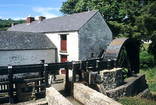
The corn mill is still in working condition but requires a skilled miller to operate it. This mill ground oats—“corn” meant oats in Ireland. (What we call corn, they called maize.) The huge waterwheel, powered by the River Swilly, made five revolutions per minute and generated eight horsepower. The entire operation could be handled by one miller, who knew every cog, lever, and flume in the joint.
• Continue on R-250, staying right (north) at Driminaught onto R-251. Stay on R-251, passing through Church Hill. You’ll enjoy bucolic landscapes of wooded hills, farms, and white cottages overlooking pretty lakes. Then the scenery shifts to a rocky and desolate terrain that feels far from civilization. Watch for signs to Glenveagh Castle and National Park; turn off on the left and park in the visitors center lot.
▲Glenveagh Castle and National Park
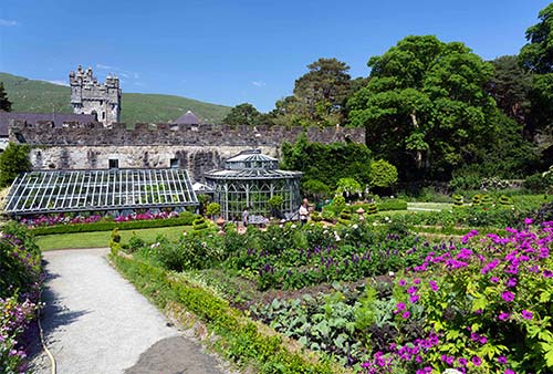
Glenveagh (GLEN-vay) is one of Ireland’s six national parks. Its jewel is pristine Lough Veagh (Loch Ghleann Bheatha in Irish)—three miles long and occupying a U-shaped valley scoured out of the Derryveagh Mountains by powerful glaciers during the last Ice Age. Visitors can hike to their hearts’ content, but the main draw here is the dramatic, turreted castle—with a somewhat less dramatic interior—perched on the lakeshore. The surrounding gardens are also striking. These sights are a long walk or quick bus ride from the visitors center; allow a couple of hours to see it all.
Cost and Hours: Park entry and castle gardens—free, castle entry—€7; castle open daily 9:30-17:30, Nov-Feb until 17:00; the park itself—and the parking lot—stay open later; +353 1 539 3167, www.glenveaghnationalpark.ie. The visitors center has free WCs and a $ café.
Getting to the Castle: The main draw is the castle, which is 2.5 miles from the visitors center. You can walk there in about 45 minutes. Most visitors opt for the shuttle bus, which departs regularly (€3 round-trip, buy ticket at visitors center, about 4/hour). Near the shuttle bus stop, you can also rent a bike or an e-bike to take along the same traffic-free path (June-Sept only, plus some weekends in shoulder season, +353 87 665 5599, www.grassroutes.ie).
Background: In the 1850s, this scenic area attracted the wealthy land speculator John George Adair, who bought the valley in 1857. Right away, Adair clashed with local tenant farmers, whom he accused of stealing his sheep. After his managing agent was found murdered, he evicted all 244 of his bitter tenants to great controversy, and set about creating a hunting estate in grand Victorian style. His pride and joy was his country mansion, Glenveagh Castle, finished in 1873 on the shore of Lough Veagh. After his death, his widow added to the castle and introduced rhododendrons and rare red deer to the estate. After her death, Harvard art professor Kingsley Porter bought the estate and promptly disappeared on the Donegal coast. (He’s thought to have drowned.) The last owner was Philadelphia millionaire Henry McIlhenny, who filled the mansion with fine art and furniture while perfecting the lush surrounding gardens. He donated the castle to the Irish nation in 1981.
Visiting the Castle: Start at the park visitors center, which explains the region’s natural history through endearing exhibits and short films. If you’d like to do a more serious hike, the attendants would love to advise you—but beware of the tiny midges that try to nest in your nostrils.
Step inside the castle, buy your ticket, and let your Jane Austen and Agatha Christie fantasies run wild. Antlers abound on walls, in chandeliers, and in paintings by Victorian hunting artists. On the ground floor, you’ll see the lived-in drawing room, study, and dining room. Head upstairs to the library, which displays paintings by George Russell and has the castle’s best lake views. In the master bedroom, at the foot of the bed, is a chest crafted from rare bog oak (from ancient trees hundreds of years old, found buried in the muck). The classy master bathroom boasts Venetian glass chandeliers. The blue room occasionally hosted Greta Garbo, who came here when she “vanted” to be alone. The bachelors’ corridor leads past more modest guest rooms to the exit.
The rest of the grounds are free, including the stony courtyard (with another handy $ café). Behind the castle, stroll through the gardens and enjoy the lovely setting. A lakeside swimming pool had boilers underneath it to keep it warm. From the top of the gardens, there’s a fine view of the castle. For the ultimate vista—of the castle, the lake, and the surrounding nature—you’ll have to huff high on the hill behind.
GLENVEAGH TO DUNFANAGHY
This next stretch feels like Donegal’s “big sky” country—with vast scenery in every direction. The next stop, Mount Errigal, is for serious hikers who’ve set aside a few hours. But anyone can enjoy views of the mountain on the right on the drive past.
• Leave the national park and follow R-251 west. To find the Mount Errigal trailhead, about 10 miles (16 km) after leaving Glenveagh, watch for the small parking lot beside R-251 on the right (easy to spot, with a low surrounding stone wall in the middle of open bog land).
Mount Errigal (An Earagail)
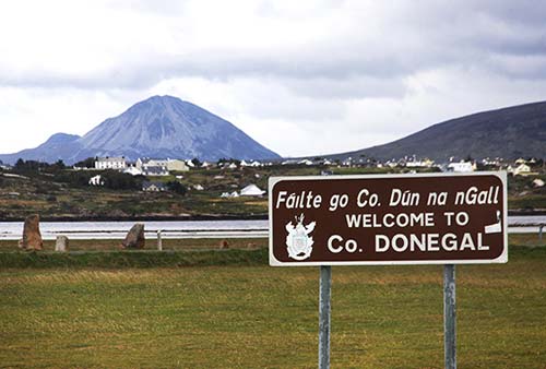
The mountain (2,400 feet) dominates the horizon for miles around. Rising from the relatively flat interior bog land, it looks taller from a distance than it actually is. Beautifully cone-shaped (but not a volcano), it offers a hearty, nontechnical climb with panoramic views (four hours round-trip, covering five miles). Hikers should get a weather report before setting out (frequent mists squat on the summit). Ask the TI in Letterkenny or Donegal town for more detailed hiking directions.
• Passing the mountain, continue on R-251 as it coasts downhill along the pretty Lough Nacung. At the “T,” turn left onto N-56 headed west; shortly after, near the end of the lake at Gweedore, turn right onto R-258 marked for Bun Beag. After 4 miles (6 km), this road reaches a T-intersection with R-257. Turn right and pass through the seaside hamlet of Bunbeg (Bun Beag).
Depart Bunbeg going north on R-257. The next 5 miles (8 km) of road heading north—as Bunbeg blends into Derrybeg (Dori Beaga) and a bit beyond—are some of the most densely populated sections of this loop. Modern holiday cottages pepper the landscape in what the Irish have come to call “Bungalow Bliss” (or “Bungalow Blight” to nature lovers). You’ll work your way uphill—with grand views over the island and cottage-scattered bay below—and turn a bend. You’re getting close to the turnoff (on the left) for...
Bloody Foreland (Cnoc Fola)
From this viewpoint, you have a grand view (to the right) of the point called “Bloody Foreland” (or “Hill of Blood”). Named for the shade of red that heather turns at sunset, this scenic headland is laced with rock walls and forgotten cottage ruins. If you brought a picnic, this is a great place to pull off at a lofty roadside viewpoint and savor a meal with rugged coastal views.
• Back on R-257, head east past peat farms, pointy peaks, humble farming communities, and wayward sheep. About 8 miles (13 km) after the viewpoint, turn left to rejoin N-56 near Gortahork. Follow N-56 east to Dunfanaghy. Just before you enter the main part of town, watch on the left for the big Workhouse sign, marking...
▲Dunfanaghy Workhouse
Opened in 1845, this structure was part of an extensive workhouse compound (separating families by gender and age)—a dreaded last resort for the utterly destitute of coastal Donegal, particularly during the Great Potato Famine. Today it houses a thoughtful exhibit on those hard times.
Cost and Hours: €5, includes audioguide; daily 10:00-17:00, Oct-April until 16:00; good book/coffee/craft shop and helpful info desk, +353 74 913 6540, www.dunfanaghyworkhouse.com.
Background: For important context, read about the Great Potato Famine on here. Dunfanaghy’s was one of over 160 “workhouse” compounds built across Ireland, and one of very few now open as a museum. The workhouse was a rigid Victorian solution to the spiraling problem of Ireland’s rapidly multiplying poor. Authorities at the time thought that poverty stemmed from laziness and should be punished. So, to motivate those lodging at the workhouse to pull themselves up by their bootstraps, conditions were intentionally made to be hard. The system was unable to cope with the starving, homeless multitudes who fell victim to the Famine, and countless workhouse inmates died.
Visiting the Museum: An informative but slow-paced, 30-minute audioguide leads you through the exhibit. The harsh workhouse experience is relayed through the true-life narrative of Wee Hannah Herrity, a wandering orphan and former resident of this workhouse. During the famine, more than 4,000 young orphan workhouse girls from across Ireland were shipped to Australia as indentured servants. But Hannah’s fate was different. She survived the famine by taking meager refuge here, dying at age 90 in 1926. With the audioguide, you’ll visit three upstairs rooms where stiff papier-mâché figures relate the powerful episodes in Hannah’s life. At the end, the 15-minute Metcalfe Movie shows footage of this area from the 1930s through 1960s.
• Now continue a few minutes more into the town of...
Dunfanaghy (Dun Fionnachaidh)
This planned town, founded by the English in the early 1600s for local markets and fairs, has a prim and proper appearance. Dunfanaghy (dun-FAN-ah-hee) is a good place to grab a pub lunch or some picnic fixings from the town market. Enjoy them from a scenic viewpoint on the nearby Horn Head loop drive (described later). The modest town square, mostly a parking lot, marks the center of Dunfanaghy (with free WCs at the harbor nearby). Helpful local info can be found on the town’s website (www.dunfanaghy.info). There are also some fine beaches near town, most notably the gorgeous Marble Hill Strand below the Shandon Hotel (a few minutes’ drive east of town).
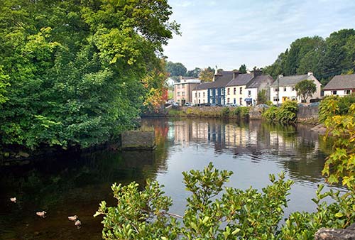
Sleeping in Dunfanaghy: There’s not much reason to sleep in Dunfanaghy, with Derry only a little over an hour’s drive away. But if you’d like to linger in Donegal, this is a fine town for it.
$$$ The Mill Dunfanaghy is a diamond in the Donegal rough. Susan Alcorn nurtures seven wonderful rooms with classy decor, in a quiet setting ideal for a romantic weekend (one mile out of town past the Dunfanaghy Workhouse on the right, +353 74 913 6985, www.themilldunfanaghy.com, info@themilldunfanaghy.com).
$$$ Shandon Hotel is a high-end, modern spa option with 68 large rooms, many looking down on lush Marble Hill Bay. You’ll find every amenity, a professional staff, an outdoor hot tub, a leisure center with an indoor pool and spa, big tour groups, and a ground-floor pub (family rooms, elevator, 3 miles east of town off N-56 at the end of Faugher Heights Road, +353 74 913 6137, www.shandonhotelspa.com, info@shandonhotelspa.com).
$$$ Arnold’s Hotel is a comfortable, old-fashioned place that’s been in the Arnold family since 1922. In the center of town, it has 30 cozy rooms that are well kept by a helpful staff (family rooms, parking, +353 74 913 6208, www.arnoldshotel.com, enquiries@arnoldshotel.com).
Eating in Dunfanaghy: Groceries are sold in the Centra Market (daily) on the main road opposite the town square. $ Muck & Muffins is a simple, lunch-only sandwich café above the pottery shop in the stone warehouse on the town square (daily, +353 74 913 6780). $$ The Oyster Bar has pub grub and live music most nights; $$ Lizzie’s, next door, has food from the same kitchen in a diner setting. My vote for most atmospheric pub in town is Patsy Dan’s, with trad tunes Monday and Friday nights (starting at 18:00); on summer weekends, they have pizza out back (daily, Main Street, +353 74 910 0604).
• From Dunfanaghy, you can return to Derry by driving south on N-56 back to Letterkenny and then onward to Derry via N-13 and A-2. (Figure a bit over an hour from Dunfanaghy to Derry, depending on traffic.)
But if you have extra time, before heading back to Letterkenny, consider a lost-world plateau drive around Horn Head. While this only adds about 20-30 minutes of driving, you’ll want at least an hour to linger over the views and enjoy.
HORN HEAD LOOP (CORRAN BINNE)
This heaving headland with few trees has memorable coastal views that make it popular with hikers.
Get off N-56, following the Horn Head signs all the way around the eastern lobe of the peninsula. There are fewer than eight kilometers (5 miles) of narrow, single-lane road out here, with very little traffic. But be alert and willing to pull over at wide spots to cooperate with oncoming cars.
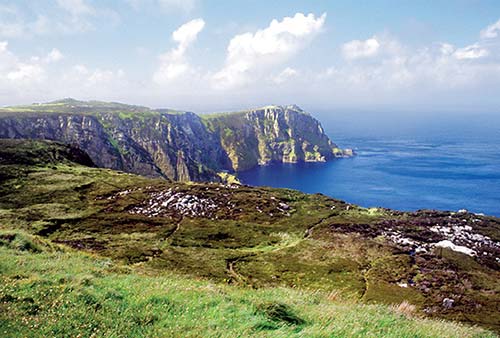
This stone-studded peninsula was once an island. Then, shortly after the last Ice Age ended, ocean currents deposited a sandy spit in the calm water behind the island. A hundred years ago, locals harvested its stabilizing dune grass, using it for roof thatching and sending it abroad to Flanders, where soldiers used it to create beds for horses during World War I. With the grass gone, the sandy spit was free to migrate again. It promptly silted up the harbor, created a true peninsula, and ruined Dunfanaghy as a port town.
A short spur road leads to the summit of the headland, where you can park your car and walk another 50 yards up to the abandoned WWII lookout shelter. The views from here are dramatic, looking west toward Tory Island and south to Mount Errigal. Some may choose to hike an additional 30 minutes across the heather, to the ruins of the distant signal tower (not a castle, but instead a lookout for a feared Napoleonic invasion), clearly visible near the cliffs. But from here, it’s still easy to bushwhack your way through (in sturdy footwear) to the rewarding cliff views at the base of the old signal tower. Navigate back to your car, using the lookout shelter on the summit as a landmark.
Between Westport and Derry
Each of these stops is either on N-15 (the main route between Sligo and Derry) or a short drive off it. I’ve listed these in the order you’ll reach them driving north from the Republic to Northern Ireland. (From Westport, follow N-5 and N-17 to Sligo. After Sligo, heading north on N-15, navigation is easy—Derry is signposted the whole way.) I’ve also suggested options for splicing in a few sights from my County Donegal Drive (earlier).
Drumcliff Village
For a classic medieval high cross, the nub of a round tower, and the grave of the poet W. B. Yeats, pull off N-15 just north of Sligo at Drumcliff (easy parking). Look for the brown signs for Yeats’ grave and the stout stone church spire peeking above the trees just off the road. Walking from the car park, you’ll pass the church, grave, café/gift shop/WC, high cross, trail to the river, and round tower.
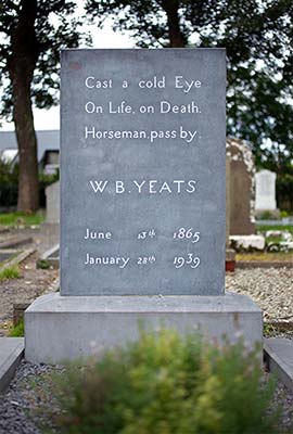
The stately little church has a delightful and stony interior (with an interesting video playing in the entryway). To the left of the church (as you face it, about 10 paces) is the simple grave of the beloved Irish poet, William Butler Yeats (1865-1939), and his wife, George. The tombstone reads: “Cast a cold eye on life, on death. Horsemen pass by.” Benbulben, the mountain that inspired Yeats, looms behind the graveyard, looking like a sphinx.
Just past the café/gift shop, find the highest cross in the graveyard. This classic high cross—along with the stub of a round tower (with its defensive door high above ground level) across the busy highway—were part of a monastic settlement a thousand years ago. These symbols of medieval Ireland once dotted the countryside.
The cross (once colorfully painted) is carved with reliefs designed to help teach the people Bible lessons. Find Adam and Eve, Cain clubbing Abel, and Christ in Majesty on one side and a camel (trying to get through the eye of a needle) on the other.
This is a historic spot: the site of a monastery founded in AD 574 by St. Columba. He and another saint had a quarrel over the rights to a book, which actually led to a battle here in which 3,000 people were killed. Columba was so distraught by the bloodshed that he eventually banished himself from Ireland and sailed to Iona (in Scotland), where he founded another monastery (famous as the original home of the magnificent Book of Kells).
Across from the high cross, a small path leads to a river path with dramatic views of Benbulben, ideal for getting into the spirit of Yeats for a moment.
Mullaghmore Head Loop
A few kilometers north of Drumcliff, leave N-15 at Cliffoney for a 6-mile (10 km) loop around Mullaghmore Head. It was just off this scenic bluff that, on August 27, 1979, the IRA detonated a radio-controlled bomb on the vacation yacht of Lord Louis Mountbatten (79-year-old second cousin of Queen Elizabeth II), killing him and members of his family.
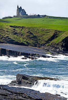
As you drive around this scenic loop, you’ll see a rugged coastline and desolate beaches with the lonely castle retreat of the royal Mountbatten family crowning the horizon. Drive past beech-tree forests (from which Lord Mountbatten constructed his boat) and a rough little stone harbor (from where he and his family sailed that fateful day), and stop at the peninsula’s far end (just 12 miles south of the border of Northern Ireland). Check out the views across Donegal Bay to where the bomb went off, just a few hundred yards offshore. Continue circling the bluff as the road brings you back to N-15.
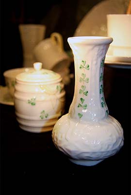
Belleek Pottery Visitors Centre
If you’re interested in pottery, consider a slight detour, about 6 miles (10 km) off N-15, over the border into Northern Ireland to the sleepy town of Belleek. The Belleek Pottery factory welcomes visitors with a small gallery and museum, a 20-minute video, a cheery cafeteria, and 30-minute guided tours of its working factory.
Cost and Hours: Visitors center—free, guided tours—£7; open Mon-Fri 9:00-16:00, Sat from 10:00, Sun from 13:00, shorter hours and closed weekends off-season; confirm tour schedule and reserve a spot in advance, +44 28 6865 8501, www.belleekpottery.ie, takethetour@belleek.ie.
Donegal Town and Castle
The main town in the Republic of Ireland’s northernmost county has a striking reconstructed castle. Donegal means “Fort of Foreigners”—a reminder that the Vikings invaded here in the ninth century. Detour 3 miles (5 km) off N-15 for a quick visit.
The charming town’s main square (“The Diamond”) is lined with inviting shops and eateries. Try the comfy café above Magee’s tweed shop. The monument in the center honors four friars who created a record of early Irish history. The small but historic Donegal Castle is a half-block beyond that (look for the pointy church spire).
Donegal Castle: This castle offers a fine chance to see a reconstructed version of the fortified towers so common in Ireland. Your entry includes an info sheet or a half-hour guided tour (€5, tours at least hourly with demand, open daily 10:00-17:30, shorter hours off-season, last entry 45 minutes before closing, www.heritageireland.ie).
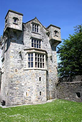
This was originally the fortified base of the mighty O’Donnell clan (originally built by Hugh O’Donnell in about 1500). Around 1600, the English defeated the O’Donnells and made the castle closer to what exists today. Wandering through the castle, you’ll see the original stone floor and 10-foot-thick walls on the ground floor, a spiral “trip staircase” winding clockwise to give the right-handed defender the advantage, the banqueting hall with its finely carved fireplace, and a top floor with historical exhibits under 40 tons of Irish oak beams—a 17th-century design with only wooden pegs holding it all together. The extension outside the tower dates from the time of the English lord’s manor house (c. 1620).
Most of Ireland’s fortified towers date from the 15th century and were initially built by the English to assert their control over the Irish. But Irish clan leaders were quick studies and began building their own. This particular castle reminds locals of the devastating Nine Years’ War (1594-1603). It started well for the Irish, here on their home turf. But when the powerful Ulster clans marched south to engage the English at Kinsale, they were crushed. Soon after, the clan royalty of Ireland (including the O’Donnells) fled the island, and English rule was firmly and brutally established.
Between Donegal and Derry
From Donegal town, it’s just over an hour to Derry in Northern Ireland. You have a couple of choices:
You can stay on N-15 to cross the border from Lifford (in the Republic) over the Foyle into Strabane (in the North), then carry on north on A-5 to Derry.
Another option, in Stranorlar (about 25 minutes out of Donegal town), is to split off onto N-13 toward Letterkenny. This is where this route meets up with my County Donegal Drive, earlier; depending on traffic, it takes only a couple of minutes longer to reach Derry than the N-15/A-5 route. With extra time, you could turn off at Letterkenny to see sights off N-13: the Newmills Corn and Flax Mills (about a 15-minute drive) or Glenveagh Castle and National Park (about 30 minutes). Even if you don’t take those detours, you’ll pass right by one of County Donegal’s most impressive sights (especially in good weather): Grianan of Aileach Ring Fort, perched high on a ridge with views of Derry (described earlier in this chapter).
Either way, near the end of your journey you’ll cross the border into Northern Ireland (see next).
Border Crossing
When you cross the border from the Republic of Ireland to the United Kingdom of Great Britain and Northern Ireland, you’ll notice lots of changes: Kilometers become miles, euros become British pounds (actually, Ulster pounds, which are the same as English pound sterling and legal tender in England), the farmland becomes richer and more productive, and Derry is now signposted as “Londonderry”—although many of the signs have the “London” spray-painted out. One thing you won’t notice, perhaps, is the border itself: Even after Brexit (in which Northern Ireland and the rest of the UK left the European Union), the borders within Ireland remain open, with no need to stop or show your passport. As you drive deeper into Northern Ireland, you’ll begin to notice Union Jack flags and communities with their curbs painted red, white, and blue.