NEAR DUBLIN
Boyne Valley • Trim • Glendalough • Wicklow Mountains • Irish National Stud
Glendalough and the Wicklow Mountains
Not far from urban Dublin, the stony skeletons of evocative ruins sprout from the lush Irish countryside. The story of Irish history is told by ancient burial mounds, early-Christian monastic settlements, huge Norman castles, and pampered estate gardens. In gentler inland terrain, the Irish love of equestrian sport is nurtured in grassy pastures ruled by spirited thoroughbreds. These sights are separated into three regions: north of Dublin (the Boyne Valley, including Brú na Bóinne and the town of Trim), south of Dublin (Powerscourt Estate Gardens, Glendalough, and the Wicklow Mountains), and west of Dublin (the Irish National Stud and Rock of Dunamase).
Boyne Valley
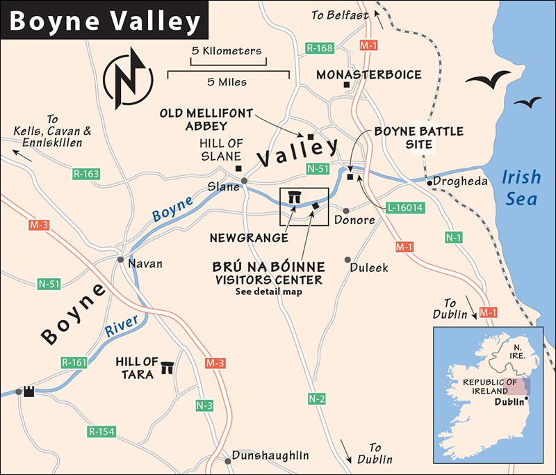
The peaceful, green Boyne Valley, 30 miles north of Dublin, has an impressive concentration of historical and spiritual sights: The enigmatic burial mounds at Brú na Bóinne are older than the Egyptian pyramids. At the Hill of Tara (seat of the high kings of Celtic Ireland), St. Patrick preached his most persuasive sermon. The valley also contains the first monastery in Ireland and several of the country’s finest high crosses. You’ll see Trim’s 13th-century castle—Ireland’s biggest—built by Norman invaders, and you can wander the site of the historic Battle of the Boyne (1690), which cemented Protestant British domination over Catholic Ireland until the 20th century.
PLANNING YOUR TIME
Of these sights, only Brú na Bóinne is worth ▲▲▲ (and deserves a good three hours). The others, while relatively meager physically, are evocative to anyone interested in Irish history and culture. If you have a car and get an early start, you could see the entire region in a day. If you’re trying to stretch your time, note that Monasterboice, Old Mellifont Abbey, and the Hill of Tara are always open, and can be visited late in the day (though if you want a guided tour, you need to get to the latter two when their visitors centers are open—see listings, later).
If you’re flying into or out of Dublin but want to avoid the intensity and expense of that big city, consider using Trim as an overnight base (45-minute drive from Dublin’s airport) and tour these sights from there.
GETTING AROUND BOYNE VALLEY
By Car: All of the described sights are within a 30-minute drive of one another. Though the sights are on tiny roads, they’re well marked with brown, tourist-friendly road signs. Just be mindful of similarly named sights in this area. For instance, it’s not unusual for drivers heading to Brú na Bóinne (the prehistoric site) to inadvertently direct their GPS to the Battle of the Boyne (battlefield/museum).
By Tour: Newgrange Tours visits Brú na Bóinne (including inside the Newgrange tomb), the Hill of Tara, and the Hill of Slane in a seven-hour trip (€75, daily pickup from several Dublin hotels, book direct via website, +353 86 355 1355, www.newgrangetours.com).
Brú na Bóinne
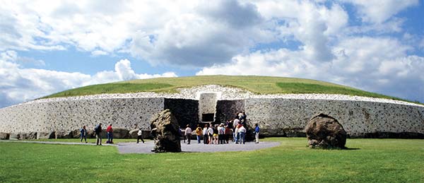
The famous archaeological site of Brú na Bóinne (broo nah BOY-nyeh, meaning “dwelling place of the Boyne”) is also commonly called “Newgrange,” after its star attraction. Here you can visit two ▲▲▲ 5,000-year-old passage tombs—Newgrange and Knowth (rhymes with “south”). These are massive grass-covered burial mounds built atop separate hills, each with a chamber inside reached by a narrow stone passage. Mysterious, thought-provoking, and mind-bogglingly old, these tombs can give you chills. Think of this place as Ireland’s answer to Stonehenge...but a thousand years older.
It’s best to visit both tombs, which are equally thrilling and complement one another well. Knowth is bigger, you can climb up on top of it, and it provides a well-rounded orientation to the entire site. Newgrange provides the “wow” experience of actually entering a passage inside a giant tomb.
Access to both sites is by guided tour only—book well in advance online (details later). For the best experience—including the passage inside Newgrange—select the “Brú na Bóinne Tour Plus Newgrange Chamber” ticket. If it’s sold out, there may be space on an outside-only tour (still worthwhile).
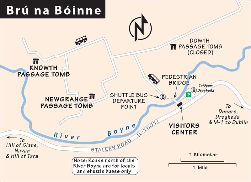
Any visit starts with the state-of-the-art visitors center, which provides context to your tomb visits; from here, you’ll walk to a shuttle bus that takes you to the tombs.
GETTING THERE
By car, drive 45 minutes north from Dublin on N-1 toward Drogheda, where Brú na Bóinne signs direct you to the visitors center (if using GPS, input “Brú na Bóinne visitor center” rather than “Newgrange,” which may direct you to the tomb itself—a few miles away and not possible to enter directly). The large, free parking lot is a five-minute walk from the visitors center.
Without a car, you can combine train and taxi service. First take a train departing Dublin Connolly station around 8:00, then get off in the town of Drogheda an hour later (confirm train times at www.irishrail.ie). From Drogheda, it’s a six-mile taxi ride to the Brú na Bóinne visitors center.
The bus is also an option: Take bus #100x from Dublin to Drogheda, then Local Link bus #188 to the visitors center (allow 2 hours each way, 4/day, check schedules at www.buseireann.ie).
It’s also possible to get to the Boyne Valley from Dublin with a tour; see the listing for “Newgrange Tours,” earlier.
ORIENTATION TO BRÚ NA BÓINNE
Cost: Brú na Bóinne Tour Plus Newgrange Chamber—€18, Newgrange Tour (exterior only)—€10, Knowth Tour—€10; all tours include visitors center exhibit (€5 on its own, but without a tomb tour, the visitors center isn’t worth the trip).
Hours: Daily 9:00-18:30, slightly shorter hours Sept-April, last bus to the tombs leaves two hours before closing, last entry to visitors center 45 minutes before closing.
Information: +353 46 942 3301, www.heritageireland.ie.
Tours: The recommended Brú na Bóinne Tour Plus Newgrange Chamber takes about 3 hours including the visitors center exhibit; the other tours take about 2 hours. There is no access to Knowth’s interior on any tour.
Book Far Ahead: To manage crowds, access to the tombs is strictly limited. You’ll need to book well in advance for any tour. Popular tours (especially the main Brú na Bóinne Tour) can sell out weeks ahead at busy times. Reserve timed-entry tickets as early as they will allow you at http://brunaboinne.admit-one.eu. If tours are sold out for your desired day, keep checking. A small number of returned tickets are resold on the website; many days, these appear between 8:30 and 9:30.
BACKGROUND
Brú na Bóinne has some of the most impressive reminders anywhere of the Neolithic (“new stone”) Age—when, with the help of stone tools, humanity transitioned from hunting and gathering to farming, and for the first time communities settled in a fixed location. This era began about 4000 BC and lasted for about 1,500 years.
Brú na Bóinne was considered sacred because of the rich resources found here. The River Boyne provided water and food (irrigation and fishing), as well as transportation, allowing those settled here to flourish.
No one knows exactly who built the 40 burial mounds found in the surrounding hills, or what became of those original inhabitants. According to recent DNA evidence, the people of Brú na Bóinne appear to have come from Anatolia (today’s Turkey) rather than Ireland.
Whoever they were, around 3200 BC, someone had a bold idea. They constructed a chamber of large stones, with a long stone-lined passage leading up to it. They covered it with a huge mound of dirt and rocks in successive layers. Sailing down the River Boyne to the sea, they beached at Clogherhead (12.5 miles from here), where they found hundreds of five-ton stones, weathered smooth by the tides. Somehow they transported these stones back up the river, possibly by tying a raft to the top of the stone so it was lifted free by a high tide. They then hauled these stones up the hill by rolling them atop logs and up dirt ramps, and laid them around the perimeter of the burial mound to hold everything in place. It would have taken anywhere from five years to a generation to construct a single large tomb. The result of all that labor was three tombs that have been uncovered so far: Newgrange, Knowth, and Dowth (which is still only partly excavated, and not included on any tour).
Why build these vast structures? Partially, it was to bury VIPs. A dead king might be carried up the hill to be cremated on a pyre. Then they’d bring his ashes into the tomb, parading by torchlight down the passage to the central chamber. The remains were placed in a ceremonial basin, mingling with those of his illustrious ancestors. (DNA evidence shows that the remains within each tomb came from related individuals, suggesting a hierarchical society that buried its ruling class together.)
The tombs also served an astronomical function; they’re precisely aligned to the movements of the sun. Newgrange is designed to be illuminated at sunrise on the shortest day of the year, the winter solstice—which to prehistoric people had important significance, marking the pivot point from the lean, cold winter months toward longer days, warmer weather, and the growing season. Dowth’s passage is illuminated at sunset on the winter solstice, and Knowth’s passages—one in each direction—line up with sunrise and sunset at both the spring and fall equinoxes.
Since the tombs are aligned with the heavens, it begs the question: Were these structures sacred places where primal Homo sapiens gathered to ponder the deepest mysteries of existence?
VISITING BRÚ NA BÓINNE
At the visitors center, check in for your tour and spend any wait time in the excellent exhibition, grabbing lunch in the cheery downstairs cafeteria, and using the WC.
Allow 10 minutes to walk to the bus stop before your assigned shuttle to the tombs. To reach the shuttle bus, exit the visitors center and follow signs over the river and across a field. You’ll meet your guide at each tomb. The recommended Brú na Bóinne Tour begins at Knowth—where you’ll get a helpful orientation to the history of this site—then ride another shuttle bus to Newgrange, for the “grand finale” experience of entering the tomb’s passage. From Newgrange, a final shuttle bus brings you back to the stop near the visitors center.
Brú na Bóinne Visitors Center Exhibition
The exhibition introduces you to the Boyne Valley and its tombs. The museum itself is modeled after the wooded river valley you must traverse to reach the sacred site. Exhibits explore what the lives of these pre-Celtic people might have been like. Tied to the seasons and eking out a livelihood with crude tools of stone, bone, or wood, they still created some intricate art. You’ll also learn about the archaeologists who first uncovered these mounds in the 1700s, walk through a re-creation of the main passage and chamber in Newgrange, and watch a contemporary, simulated interpretation of a ceremony that might have been held inside.
Knowth
This impressive necropolis features one grand hill-topping mound surrounded by several smaller satellite mounds. The Knowth site thrived from 3000 to 2000 BC. The central tomb dates from about 2000 BC. It was likely used for burial rituals and sun-tracking ceremonies to please the gods and ensure the regular progression of seasons for crops. The site then evolved into the domain of fairies and myths for the next 2,000 years and became an Iron Age fortress in the early centuries after Christ. Around AD 1000, it was an all-Ireland political center, and later, a Norman fortress was built atop the mound.
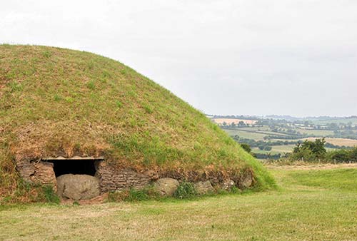
At 220 feet wide and 40 feet high (and covering 1.5 acres), the central tomb is justifiably called the Great Mound. Circling the mound, with its sod roof resembling a gigantic mushroom, you’ll see plenty of curbstones (or “kerbstones”) carved with intricate prehistoric artwork—not of people or animals, but abstract, geometrical patterns, typical of Neolithic art around the world. They were created with super-hard flint tools, since people had not yet mastered metal. Notice repeating motifs of crosshatches, bull’s-eyes, and chevrons; experts can only guess at the significance. A series of circles may have represented the phases of the moon. Spirals (a perpetual loop) could symbolize cycles—of the sun, of life and death, or of the seasons. (For more on prehistoric art, see here.)
Knowth’s big tomb has two passages (or “souterrains”): one entering from the east, and one from the west, which don’t quite meet in the middle. These may have been used for storage and/or for escape. Like at Newgrange, these passages were aligned so the rising and setting sun shone down the passageways to light the two interior chambers; unlike at Newgrange, these are illuminated at the equinox rather than the solstice. Neither passage is open to the public, but you may get a glimpse down one of them.
The central mound is ringed by 22 grassy satellite mounds (some are recent re-creations). Notice how the large, central tomb has begun to “absorb” some of these smaller ones—suggesting that the Great Mound was gradually expanded over time. You’ll also see a wooden henge, re-created from existing postholes. Originally, this structure may have been roofed.
Before leaving, you can climb to the top of the tomb. Standing here 4,000 years after prehistoric people built these strange tombs, you can look out over the surrounding countryside and contemplate the passage of time.
Across the street from the site entrance, next to the bus stop, you’ll find WCs and a small exhibit with a film about the archaeology of the site—a handy place to kill time waiting for your onward bus to Newgrange.
Newgrange
This grassy mound atop a hill is 250 feet across and 40 feet high. Dating from 3200 BC, Newgrange is 500 years older than the pyramids at Giza. The base of the mound is ringed by dozens of curbstones, each about nine feet long and weighing five tons. Just like Knowth, most of Newgrange’s curbstones have designs carved into them.
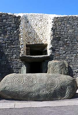
The entrance facade is a mosaic of white quartz and dark granite. This is a reconstruction done in the 1970s, and not every archaeologist agrees it originally looked like this. Above the doorway is a square window called the roofbox, which played a key role (as we’ll see). In front of the doorway lies the most famous of the curbstones, the 10-by-4-foot entrance stone. Its left half is carved with three mysterious spirals, unique to Newgrange, which have become a kind of poster child for prehistoric art.
Entering the tomb, you walk down a narrow 60-foot passage lined with big boulders. The passage opens into a central room—a cross-shaped central chamber with three alcoves, topped by a 20-foot-high igloo-type stone dome. It’s an impressive engineering feat: This dry-stone structure, which uses no mortar, is the best surviving example in Europe of a corbel vault ceiling. Bones and cremated remains were placed here in a ceremonial stone basin, under 200,000 tons of stone and dirt.
While we know nothing of Newgrange’s builders, it most certainly was a sacred spot—for a cult of the dead, a cult of the sun, or both. The tomb is aligned precisely east-west. As the sun rises around the shortest day of the year (winter solstice—usually on Dec 21—and two days before and after), a ray of light enters through the roofbox and creeps slowly down the passageway. For 17 minutes, it lights the center of the sacred chamber (your guide will demonstrate this). Perhaps this was the moment when the souls of the dead were transported to the afterlife, via that ray of light. Then the light passes on, and, for the next 361 days, the tomb sits again in total darkness.
If you’d like to come back someday to be inside Newgrange for the winter solstice—to see it illuminated just as its prehistoric builders intended—you can enter a raffle back at the visitors center.
More Boyne Valley Sights
NORTH OF BRÚ NA BÓINNE
The following sights are all within a 10- to 20-minute drive north of Brú na Bóinne and easy to connect to each other.
▲Battle of the Boyne Site
While a footnote in the grand sweep of Europe’s military history, this battleground looms huge in the story of the British Isles. This is the pastoral riverside site of the pivotal 1690 battle in which the Protestant British decisively broke Catholic resistance, establishing Protestant rule over all of Ireland and Britain. In a sense, the Troubles began right here, at a tight bend in the River Boyne. And today, while there’s little to see of the actual battle site, a concise and informative museum tells the story.
Cost and Hours: €5; daily 10:00-17:00, Oct-April 9:00-16:00, last entry one hour before closing; beautiful garden café, +353 41 980 9950, www.battleoftheboyne.ie.
Getting There: The visitors center is on the south bank of the River Boyne, about two miles north of the village of Donore. It’s well signposted for drivers from M-1, N-51, or N-2. Once you pass through the main gates, park in the big, free lot and walk five minutes to the visitors center in the mansion up the driveway.
Visiting the Site: The visitors center is housed in a mansion built on the battlefield 50 years after the conflict. The exhibits do a good job of illustrating the international nature of the battle and its place in the wider context of European political power struggles. You’ll walk through dioramas that re-create the night before the battle, with officers and soldiers huddled in tents. Rifles and swords are on display, along with a painting of the battle by Dutch military painter Jan Wyck—who was invited to witness the event in person by the very confident King William, so that the painter could properly commemorate his grand victory. The highlight is a huge battleground model with laser lights that move troops around the terrain, showing the battle’s ebb and flow on that bloody day. Outside, a 13-minute film running continuously in the former stable house further fleshes out the battle.
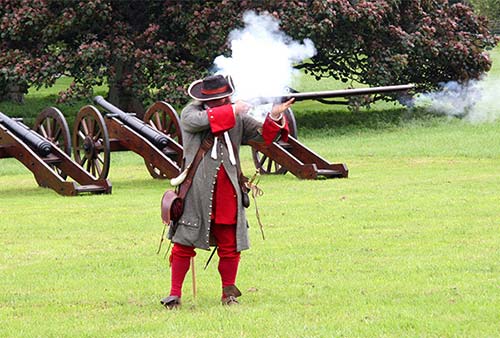
Before leaving, be sure to follow signs to the stunning walled garden, where you can go for a stroll or enjoy a drink or meal at the café.
As far as the battlefield itself...there’s not much to see. You can pick up a free map at the visitors center that illustrates a few routes through the fields. But even along those routes, locations tied to the battle are sparsely explained.
As you exit the site to the north (on the L-16014 access road that connects to the main N-51 road), you’ll cross the River Boyne on a metal bridge, locally referred to as the Obelisk Bridge. This spot is where the most frantic action took place on the day of the battle.
Pull over and gaze at the river. Picture crack Dutch troops (from King William’s homeland) marching south in formation. They were the first to cross the river here, while their comrades behind on the north bank covered their exposed position with constant protective fire. Low tides (the sea is only 7 miles downstream) allowed these soldiers to cross the river in water up to their waists. With the gun smoke, weapon fire, and shouts in the close, chaotic combat, it was tough to tell friend from foe. Neither force had standard uniforms, so King William’s troops wore sprigs of green while the troops of King James pinned white paper to their coats. Both sides bled red.
Old Mellifont Abbey
This Cistercian abbey (the first in Ireland) was established by French monks who came to the country in 1142 to bring the Irish monks more in line with Rome. (Even the abbey’s architecture was unusual, marking the first time in Ireland that a formal, European-style monastic layout was used.) Cistercians lived isolated rural lives; lay monks worked the land, allowing the more educated monks to devote all of their energy to prayer. After Henry VIII dissolved the abbey in 1539, centuries of locals used it as a handy quarry. Consequently, little survives beyond the lavabo (where monks would ceremonially wash their hands before entering the refectory to eat), which now stands lonesome in the middle of a field, surrounded by rubble. This sight is evocative but subtle, of interest mainly to historians and aficionados of medieval monastic architecture. To fully appreciate the story of the Cistercians before you visit, read the sidebar on here.
Cost and Hours: Site is free to enter and always open; museum and guided tour—€5, late-May-mid-Sept daily 10:00-18:00, last entry 45 minutes before closing, museum closed and no tours off-season; +353 41 982 6459, www.heritageireland.ie.
Visiting the Abbey: It’s worth paying for a tour, which helps tell the story of this once-grand complex (tours depart with demand). The price includes admission to the tiny, skippable, one-room museum where, amidst a scattering of stone fragments, you’ll find a model of the reconstructed abbey.
If touring the site on your own, you can see most of it from the overlook at the edge of the free parking lot: Straight ahead, you’re looking down the transept of what was the abbey church. Beyond that is the chapter house where the monks lived, then the infirmary. The grassy field in the middle of the complex (on the right) was the cloister garden, with the surviving octagonal lavabo that gives the best sense of the abbey’s former grandeur. On the right (west) side of the garden are the ruins of a storehouse, and the quarters for the lay brothers who supported the abbey’s work.
From where you’re standing, steps on the left lead down through the foundations of the church and other buildings; you’re free to wander among them.
▲Monasterboice
This ruined monastery is visit-worthy for its round tower and ornately carved high crosses—two of the best such crosses in Ireland. In the early Middle Ages, these crosses, illustrated from top to bottom with Bible stories, gave monks a teaching tool as they preached to the illiterate masses. Imagine the crosses in their prime, brightly painted, before years of wind and rain weathered the paint away. Today, Monasterboice is basically an old graveyard.
Cost and Hours: Free and always open, good information boards, free parking lot with WCs just across the road.
Visiting the Site: Head through the gate, up the path, and into the monastery graveyard, where you’ll run right into the 18-foot-tall Cross of Murdock (Muiredach’s Cross, c. 923, named after an abbot). This is considered the best high cross in all of Ireland. The circle—which characterizes the Irish high cross—could represent the perfection of God. Or, to help ease pagans into Christianity, it may represent the sun, which was worshipped in pre-Christian Celtic society. Whatever its symbolic purpose, its practical function was to support the weight of the crossbeam.
Face the cross (with the round tower in the background) and study the carved sandstone. The center panel shows the Last Judgment, with Christ under a dove, symbolizing the Holy Spirit. Those going to heaven are on Christ’s right, and the damned are being ushered away by a pitchfork-wielding devil on his left. Working down, you’ll see the Archangel Michael weighing souls, as the Devil tugs demonically at the scales; the adoration of the three—or four—Magi; Moses striking the rock to bring forth water; scenes from the life of David; and, finally, Adam, Eve, and the apple next to Cain slaying Abel. Imagine these carvings with their original, colorful paint jobs. Check out the plaque at the base of the nearby tree, which further explains the carvings on the cross.
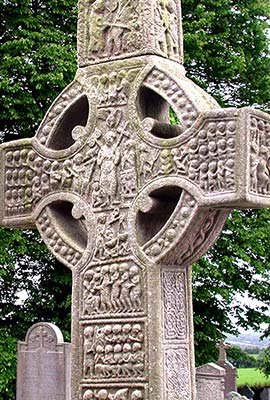
Find the even-taller West Cross, nearest the tower. It seems the top section was broken off and buried for a period, which protected it from weathering. The bottom part remained standing, enduring the erosive effect of Irish weather, which smeared the once-crisp features. Carvings on one side feature the Crucifixion; on the other side are scenes from the Last Judgment.
The door to the round tower was originally 15-20 feet above the ground (accessible by ladder). After centuries of burials, the ground level has risen—and the tower is missing its top.
SOUTH OF BRÚ NA BÓINNE
The Hill of Tara is located about 30 minutes southwest of Brú na Bóinne and 20 minutes east of Trim.
▲Hill of Tara
This pastoral hilltop was the most important center of political and religious power in pre-Christian Ireland. While ancient Ireland was a pig pile of minor chieftain-kings scrambling for power, the High King of Tara had special status. Aerial views of this site show plenty of mystifying circles and lines; in real life, wandering with the sheep among the well-worn ditches and mounds leaves you with more to feel than to see (other than sweeping views over the Emerald Isle). Visits are made meaningful by an excellent 20-minute video presentation and the insightful 20-minute guided walk that usually follows (tours typically begin at the top of the hour, but schedule can change due to frequent big bus tours; call ahead to confirm). Wear good walking shoes—the ground is uneven and often wet.
Cost and Hours: The hilltop site is free and always open. The visitors center and guided walk are also free (but there may be a charge by the time you visit); open mid-May-mid-Sept daily 10:00-18:00, last tour at 17:00; off-season the site remains open but the visitors center is closed; WCs in café next to parking lot, +353 46 902 5903, www.heritageireland.ie.
Parking: Park near the café at the base of the hill; here you’ll find both free and paid parking areas. Go through the gate and walk about five minutes uphill to the church under the trees—this houses the visitors center.
Visiting the Site: The sites along the hill are scant and barely explained; ideally time your visit to take the guided walk. Otherwise, ask at the visitors center for the free map/guide, and use it to follow this description. While the origins of this sacred site are mind-bogglingly old, you’ll also see reminders of other, far more recent chapters of Irish history—an indication of the importance of this site in the national consciousness across millennia.
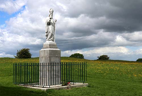
Near the visitors center, the statue of St. Patrick marks the entrance to the hilltop. It was at this ancient stockade that Patrick directly challenged the king’s authority. When confronted by the high king, Patrick convincingly explained the Holy Trinity using a shamrock: three petals with one stem. He won the right to preach Christianity throughout Ireland, and the country had a new national symbol.
Continue uphill past St. Patrick. Stretching to your right are the parallel earthen banks called “the Banqueting Hall”—which may or may not have been the foundations of a medieval banqueting hall.
Turn 180 degrees and walk along the hill, toward mounds, trenches, and other earthworks that undulate the terrain. The first (roped-off) area you’ll pass, on the left along the church wall, is called the Rath of the Synods. This was disturbed a century ago by amateur archaeologists on a “dig.” A small group of British Israelites—who believed they were one of the lost tribes of Israel who had ended up in Britain—spent 1899 to 1901 recklessly digging up parts of the hill in a misguided search for the Ark of the Covenant.
Farther along, you’ll soon reach the most perfectly formed mound—the Mound of Hostages (though the original term means something more like “supporters”). Circling around its back side, notice a passage dug into its side. Like Newgrange, this is a Bronze Age passage grave (c. 3500 BC)—the cremated remains of hundreds of people were found inside.
Farther along, on your right, is another round hilltop called the Forrad, which was probably used for the inauguration of the Kings of Tara. Today it’s topped by two different memorials that honor the same modern event: In 1798, passionate young Irish rebels staged an ambush on British troops, then withdrew to Tara for its defensible position. However, they were ultimately routed by better-organized (and more-sober) British forces. (The cunning British commander had sent three cartloads of whiskey along the nearby road earlier in the day, knowing the rebels would intercept it.) The modern grave-like marker was added here to commemorate that sacrifice, and the round ancient stone was moved here for the same purpose. And yet a third marker—the fenced-off stone cross a bit lower on the hill—also recalls the same event. As you can see, this site is a bit of a hodgepodge, with each successive generation making its own amendments.
Adjoining the Forrad in a figure-eight pattern is another mound, called Cormac’s House (Tech Cormaic). As you pause here to look over the Hill of Tara, consider one more event tied to the hill: In 1843, the great orator and champion of Irish liberty Daniel O’Connell gathered 500,000 Irish peasants here for his greatest “monster meeting”—a peaceful show of force demanding the repeal of the Act of Union with Britain (kind of the Woodstock of its day).
Stand on the Hill of Tara. Think of the history it’s seen, and survey Ireland. It’s understandable why this “meeting place of heroes” continues to hold a powerful place in the Irish psyche.
Trim
The sleepy, workaday burg of Trim (pop. 9,000), straddling the River Boyne, is marked by the towering ruins of Trim Castle. Trim feels littered with mighty ruins that seem to say, “This little town was big-time...800 years ago.” These days, locals are mainly proud of their strong showing in Ireland’s annual Tidy Towns contest. (They won the whole shebang in 2022.)
The tall Yellow Steeple (over the river from the castle) is all that remains of the 14th-century Augustinian Abbey of St. Mary. Not far away, the Sheep’s Gate is a humble remnant of the once-grand medieval town walls. The bridge that rumbles over the River Boyne in the heart of town is one of Ireland’s oldest. And near the town center, the modest, 30-foot-tall Wellington Column honors native son Arthur Wellesley, the First Duke of Wellington (1769-1852), who spent his childhood in Trim, defeated Napoleon at Waterloo, and twice became prime minister.
Trim makes a great landing pad into—or launching pad out of—Ireland. If you’re flying into or out of Dublin Airport and don’t want to deal with big-city Dublin, this is a perfect alternative—an easy 45-minute, 30-mile drive away. You can rent a car at the airport and make Trim your first overnight base (getting used to driving here in easier country traffic). Or spend your last night here before returning your car at the airport. Weather permitting, my evening stroll makes for a fine first or last night on the Emerald Isle.
Orientation to Trim
The main square of Trim is a traffic roundabout, and everything’s within a few blocks. Most of the shops and eateries are on or near Market Street, along with a supermarket.
TOURIST INFORMATION
The TI is right next to the castle entrance and includes a small, free exhibit on Trim’s history (Mon-Fri 10:00-17:00, closed Sat-Sun, Castle Street, +353 46 943 7227).
HELPFUL HINTS
Laundry: The launderette is located close to Market Street (Mon-Fri 9:00-17:00, Sat until 15:00, closed Sun, Watergate Street, +353 86 844 4299).
Taxi: For visits to nearby Boyne sites, Donie Quinn can give you a lift (+353 46 943 6009).
Parking: You’ll find pay parking along the streets and a small parking lot directly in front of the castle entrance.
Adventure Tours: The menu at Boyne Valley Activities includes kayaking, rafting, and archery excursions (book ahead, +353 86 734 2585, www.boynevalleyactivities.ie).
Sights in Trim
▲▲Trim Castle
This is the biggest Norman castle in Ireland. Set in a grassy riverside park in the heart of this sleepy town, its mighty keep towers above a ruined outer wall. Visitors enjoy a free ramble through its grounds—littered with foundations of ages past—or can pay to tour the central keep. Even from afar, it’s a striking fortress.
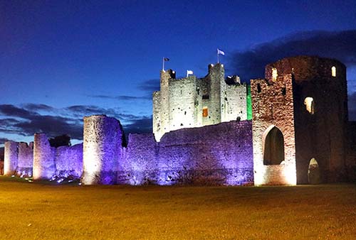
Today’s castle replaced a wooden fortification that was destroyed in 1173 by Irish High King Rory O’Connor, who led a raid against the invading Normans. The castle was completed in the 1220s and served as a powerful Norman statement to the restless Irish natives. It remained a sharp barb at the fringe of “the Pale” (English-controlled territory), when English rule shrank to just the area around Dublin in the 1400s. By that time, any lands farther west were “beyond the Pale.” Today the castle remains an impressive sight—so impressive that it was used in the 1994 filming of Braveheart (which was about Scotland’s—not Ireland’s—fight for freedom from the English).
Cost and Hours: Grounds—free, €5 for entrance to keep and required tour (see below); daily 10:00-17:00, Nov-mid-Feb Sat-Sun only 9:30-16:30; +353 46 943 8619, www.heritageireland.ie.
Tours: The only way to enter the keep (the only still-standing structure on the grounds) is by 45-minute guided tour. These run frequently (about 2/hour) but can fill up (busiest mid-morning and mid-afternoon); arrive early in the day or call ahead for the day’s schedule. The tour starts at the cool ground-floor models that show the evolution of the castle. Then you’ll climb a series of tightly winding original staircases and modern high catwalks, learn about life in the castle, and end at the top with great views of the walls and the countryside. If you miss out on a tour, the grounds are easy to see using the description below.
Visiting the Castle: Before you head inside—or if you’re killing time waiting for a keep tour—consider walking around the outside of the walls (about 15 minutes to circle it). Along the way, stop at the informative plaques that show the castle from each viewpoint during its gory glory days. Along the wall just past the TI, an information plaque shows the castle all dolled up for its scenes in Braveheart. The entire complex is surrounded by a “curtain wall.” At the wall’s base, notice the cleverly angled “batter” wall—used by defenders who hurled down stones that banked off at great velocity into the attacking army. Notice also that the castle is built directly on bedrock, visible along the base of the walls. During sieges, while defenders of other castles feared that attackers would tunnel underground to weaken the defensive walls, that was not an issue here.
Now head up the ramp to go inside the castle. The site is sparsely explained, but worth a stroll. The massive 70-foot-high central keep, which is mostly a hollow shell, has 20 sides. This experimental design was not implemented elsewhere, as it required more defenders to cover all the angles.
On the left as you enter the castle courtyard is the footprint of the Great Hall, built during a period of relative peace (in the late 13th century) as a more pleasant space for important meetings and events than the dark, claustrophobic keep. (It even offered views over the river and abbey.) Tucked to its left, at the most heavily fortified corner, was the Solar, with four floors of private apartments.
Circling around to the opposite side of the keep, you can step inside the round Barbican Gate, protected by two drawbridges. Between the Barbican Gate and the Great Hall was the River Gate, where goods could be delivered directly into the castle. It’s all enough to give historians goosebumps.
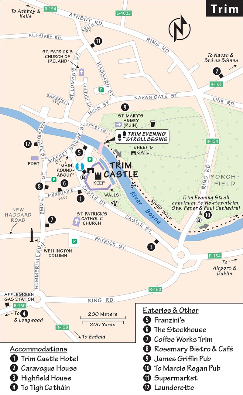
▲Trim Evening Stroll
In good weather, this one-hour round-trip walk is a handy blueprint for a fine night in Trim. (Figure about one mile of level walking each way.)
Start by taking the pleasant River Walk stroll along the River Boyne from Trim Castle. Cross the metal-frame footbridge over the river behind the castle and turn right (east).
The paved, level trail leads under a modern bridge/overpass and extends a mile along fields that serfs farmed 750 years ago—an area called the Porchfield (likely named for the French porte, or gate). During the filming of Braveheart, Mel Gibson’s character met the French princess in her tent in these fields. You’ll pass an information plaque explaining life in medieval Trim.
The trail ends in the medieval ruins of Newtowntrim; its former cathedral is the pointy top you can see from afar. This was indeed once the “new town” (mid-1200s) that sprouted as a religious satellite community to support the political power housed in the castle.
Wander the sprawling, ragtag ruins of Sts. Peter and Paul Cathedral (1206), once the largest Gothic church in Ireland. Then continue walking along the river, alongside the many evocative headstones. Near the far end of the cemetery, on the left, you’ll see the ruins of a smaller church. Inside these foundations, the altar area holds an elevated tomb with a carved lid depicting a medieval lord and lady—known locally as the tomb of the “jealous man and woman” (because they do not touch each other). Upon close inspection, you’ll notice hundreds of tiny pins in the creases of the carving, left behind by superstitious visitors. Why? If you rub a pin on your stubborn wart and then leave it here…presto: wart-be-gone.
Just beyond the ruins, cross the old Norman bridge to the 13th-century scraps of the Hospital of St. John the Baptist. Medieval medicine couldn’t have been fun, but this hospital was the best you could hope for back when life was nasty, brutish, and short.
Cross back over the bridge and stop for a pint at tiny, atmospheric Marcie Regan, one of the oldest pubs in Ireland (an exterior sign calls it “Regan,” but most locals call it “Marcie’s”). Explore its dimly lit back rooms. While they ’on’t serve food, it’s a delightful place for a drink. There’s a big beer garden out back and, along the other side, a small yard has fine views over one of the oldest bridges in Ireland (the one you just crossed), with the hospital just beyond.
To return to town, walk back along the river the way you came. Have dinner, followed by a lap around the castle (beautifully lit at night). End the evening a few blocks away with a pint at the recommended James Griffin pub. A fine night ’tis...or ’twas.
Sleeping in Trim
Because Trim is a popular spot for weddings, book as early as possible if you’re visiting on a summer weekend.
$$$ Trim Castle Hotel is the town’s modern option, with 68 rooms, some with direct views of the castle, and a friendly downstairs pub (family rooms, air-con in some rooms, elevator, parking, Castle Street, +353 46 948 3000, www.trimcastlehotel.com, info@trimcastlehotel.com).
$$$ Caravogue House (a pun on the owner’s name, Caroline, and “vogue”) is a fresh, modern, stylish, and lovingly tended B&B with 11 rooms. It’s along a road outside the city center, a quick drive or 15-minute walk from the castle (family room, parking, Navan Road, +353 46 949 0499, www.caravoguehouse.ie, rooms@caravoguehouse.ie).
$$ Highfield House, across the street from the castle and a five-minute walk from town, is a stately former maternity hospital with hardwood floors and 10 spacious, high-ceilinged rooms (no breakfast, parking, family rooms; above the roundabout where the road from Dublin hits Trim, Castle Street, +353 86 857 7115, www.highfieldguesthouse.com, info@highfieldguesthouse.com, Geraldine and Edward Duignan).
$$ Tigh Catháin, in the countryside a mile southwest of town, has four large, bright, lacy rooms with a comfy, rural feel, in a charming house surrounded by greenery and gardens. Owner Marie Keane offers classic B&B friendliness (cash only, continental breakfast in room, along R-160/Longwood Road—up the lane 200 yards past the Applegreen gas station, +353 86 257 7313, www.tighcathain-bnb.com [URL inactive], tighcathain.bnb@gmail.com).
Eating in Trim
A country market town, Trim isn’t a place for high cuisine; rather, you’ll find basic meat-and-potatoes options. My first two listings are the only full restaurants in town. Otherwise, the spots along Market Street are friendly, wholesome, and unassuming.
$$ Franzini’s is ideally located right next to the castle, with a modern interior (including some castle-view tables). The menu is straightforward, reliable comfort food: pasta, steak, fish, and salads (dinner only, closed Mon-Tue, on French’s Lane across from the castle parking lot, +353 46 943 1002).
$$$ The Stockhouse serves hearty steaks and poultry, plus creative desserts. The prices are a bit high, but the place is lively and fun-loving. Sit upstairs and take in the history of Trim from the walls while you wait (Wed-Sat dinner only, Sun lunch and dinner, closed Mon-Tue, Finnegan’s Way, +353 46 943 7388).
$ Coffee Works Trim is an appealing modern café, with good coffee and pastries and great sandwiches. It’s a good takeout option for a busy day of side-tripping (daily until 17:00, Emmet Street, www.coffeeworks.ie).
$ Rosemary Bistro & Café is a reliable breakfast and lunch joint for standard Irish diner food (no dinner, closed Sun, 9 Emmet Street, +353 46 948 4814).
Pubs: For a fun pub experience, check out Trim’s two best watering holes. The James Griffin (very central, on High Street) is full of local characters with traditional Irish music sessions plus other music many nights. Farther out of town—a short drive or long walk away—locals fill the tiny, creaky, low-ceilinged, atmospheric Marcie Regan (at the north end of the old Norman bridge over the River Boyne, next to the ruins of Newtowntrim; +353 86 336 2410). In good weather, it’s fun to walk here on my “Trim Evening Stroll” (see listing earlier).
Supermarket: The large SuperValu is your best bet (on Haggard Street, a short walk from the town center).
Trim Connections
Trim has no train station. Buses between Trim and Dublin (almost hourly, 1 hour, www.buseireann.ie) stop at the bus shelter next to the TI and castle entrance on Castle Street.
Glendalough and the Wicklow Mountains
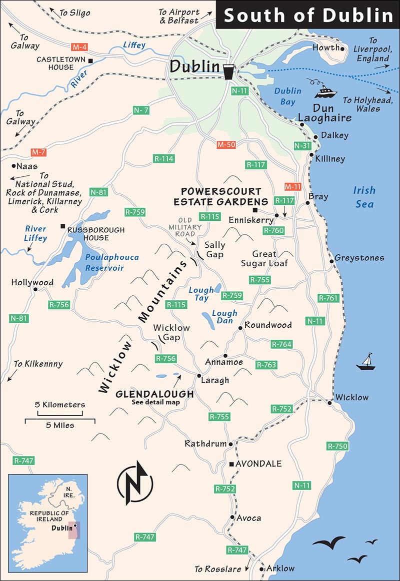
The Wicklow Mountains, while only 15 miles south of Dublin, feel remote—enough so to have provided a handy refuge for opponents to English rule. Rebels who took part in the 1798 Irish Rebellion hid out here. The area became more accessible in 1800, when the frustrated British built a military road to help flush out the rebels. Today, this same road—now R-115—takes you through the Wicklow area to Glendalough at its south end. While the valley is the darling of Dublin day-trip tour organizers, for the most part it doesn’t live up to the hype. But two blockbuster sights—Glendalough and the Powerscourt Estate Gardens—make a visit worth considering.
GETTING AROUND THE WICKLOW AREA
This area is best by car. Take N-11 south from Dublin toward Bray, then R-117 to Enniskerry, the gateway to the Wicklow Mountains. Signs direct you to Powerscourt, and then on to Glendalough. From Glendalough, if you’re heading west, you can leave the valley and reach highway N-81 by going over the famous but dull mountain pass called the Wicklow Gap.
If you lack a car, I’d skip this area; there are better (and easier) places for nondrivers to see.
Sights in the Wicklow Area
▲▲Powerscourt Estate Gardens
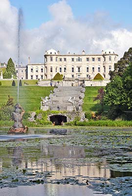
A mile above the village of Enniskerry, these meticulously kept gardens are Ireland’s best, covering 47 acres within a 700-acre estate. The dreamy driveway alone is a mile long. Ringed by dramatic hills, and with fine Japanese and Italian gardens, and a sweet pet cemetery along the way, this attraction provides the scenic greenery I hoped to find in the rest of the Wicklow area.
Cost and Hours: €12.50, daily 9:30-17:30, Nov-Feb until dusk, terrace café with views over gardens, +353 1 204 6000, www.powerscourt.com.
Parking: There’s ample free parking nearby, at a distillery and garden center, about a five-minute walk to the house (you’ll pass a gauntlet of shops on your way to the ticket desk).
Background: The house was commissioned in the 1730s by Richard Wingfield, first viscount of Powerscourt. The gardens you see today were mostly created during the Victorian era (1858-1875). The mansion’s interior is still only partially restored after a 1974 fire (and available only for special events). Parts of The Count of Monte Cristo movie were filmed in this well-watered aristocratic fantasy.
Visiting the Gardens: Before leaving the house and heading out to the gardens, watch the 10-minute film that provides a history of the estate (plays continuously).
The gardens’ 1.5-mile counterclockwise loop is simple. You could see it all on a brisk, 45-minute walk...but in good weather, it’s worth lingering. Audioguide QR codes are posted throughout.
First, head down the grand stairs in front of the house for the “wow” moment this place was designed to create. This Italian Garden was inspired by the great palaces of Europe. (The impressive summit of the Great Sugar Loaf mountain hovers as a backdrop.) Next, head right to enter the lush and varied Walled Garden. Emerging at the far end, circle around the Dolphin Pond, then keep an eye out for the small, fenced pet cemetery, just below the path. Animal lovers may find some of the epitaphs relatable. You can then detour to the Rhododendron Walk just below the cemetery, or simply continue along the path to round the bottom end of Triton Lake—the fountain-spouting centerpiece of the entire garden. The views from here back up to the house are grand.
Finally, head into a gully filled with a beautiful Japanese Garden. Climbing out the other side, follow Tower Valley (with its soaring trees) until you reach the Pepperpot Tower, which you can climb for a modest view. From there, it’s a quick walk back to the main house and the exit.
▲Old Military Road over Sally Gap
If driving from Powerscourt Gardens to Glendalough, rather than hopping on the highway, consider taking this scenic drive (worth the extra 30 minutes or so). From the gardens and Enniskerry, follow signs toward Glencree. Look for the German military cemetery, built for U-boat sailors who washed ashore in World War II.
When you reach a T-intersection, turn left onto the tiny old military road (R-115) to head over Sally Gap and through the best scenery of the Wicklow Mountains (on Sundays, watch for dozens of bicycle racers). This above-it-all terrain, with heather and ferns, feels a world away from Dublin. Notice the peat bogs and the freshly cut peat bricks drying in the wind. Many locals are nostalgic for the “good old days,” when homes were always peat-fire heated.
At the Sally Gap junction, turn left onto R-759 (marked for Roundwood and Bray), which winds through the vast Guinness estate. Look down on your right to view the glacial lake (Lough Tay); it’s nicknamed “Guinness Lake,” as its water resembles Ireland’s favorite dark-brown stout while the sand of the beach looks like the head of a Guinness beer. From here, the road meanders scenically down into the village of Roundwood and on to Glendalough.
▲▲Glendalough
The steep wooded slopes of Glendalough (GLEN-da-lock, “Valley of the Two Lakes”) hide Ireland’s most impressive monastic settlement. This is a fine opportunity to wander through an evocative landscape of long-abandoned monastic buildings—scattered with crooked, moss-covered Celtic cross tombstones—and to learn about this dramatic chapter of Ireland’s history. A visit here can be as simple as a 30-minute wander through the ruins, or a half-day (or longer) experience: learning about the history in the visitors center, then hiking in the lush forests around the upper and lower lakes.
Cost and Hours: Free to enter site, €5 for visitors center; daily 9:30-18:00, until 17:00 in winter, last entry 45 minutes before closing; pay parking, +353 46 940 7156, www.heritageireland.ie.
Tours: Every day from April to mid-Oct, the visitors center offers a 35-minute tour at 15:00 (included in entry ticket). It’s worth planning your day around this tour, which also coincides with a less-crowded time.
Crowd Alert: Glendalough can be jammed with tour-bus groups in summer—all day on weekends and 11:00-14:00 on weekdays.
Eating: There’s no café at the visitors center, but the adjacent hotel has multiple eating options, and you’ll find even more along the road nearby.
Background: Founded by St. Kevin in the sixth century, the monastery flourished (despite repeated Viking raids) throughout the Age of Saints and Scholars until the English destroyed it in 1398. A few hardy holy men continued to live here until it was finally abandoned during the Dissolution of the Monasteries in 1539. But pilgrims kept coming, especially on St. Kevin’s Day, June 3. (This might have something to do with the fact that a pope said seven visits to Glendalough had the same indulgence value as one visit to Rome.) While much restoration was done in the 1870s, most of the buildings date from the 10th to 12th century.
In an Ireland without cities, these monastic communities were mainstays of civilization. At such remote outposts, ascetics (with a taste for scenic settings, but abstaining from worldly pleasures) gathered to commune with God. In the 12th century, with the arrival of grander monastic orders such as the Cistercians, Benedictines, Augustinians, Franciscans, and Dominicans, and with the growth of cities, these monastic communities were eclipsed. Today, Ireland is dotted with the reminders of this age: illuminated manuscripts, simple churches, carved crosses, and about 100 round towers.
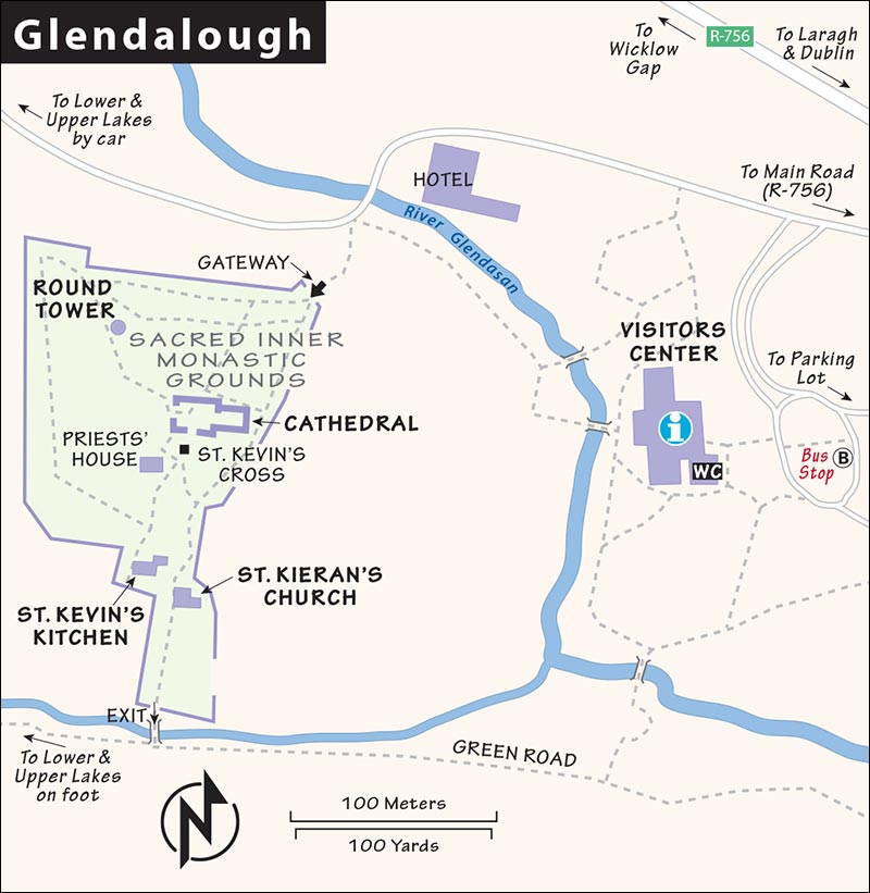
Visiting Glendalough: A visit here has three parts—but only one (the ruined monastery complex) is essential. First, check out the visitors center, with a film and exhibit that help bring meaning to the site (and ideally take their afternoon tour). Then, head behind the visitors center to wander the evocative site. Finally, if you have time, interest, and good weather, explore the lakes and parklands beyond the site. I’ve described each section below.
Visitors Center: A dry but informative 12-minute video provides a good thumbnail background on monastic society in medieval Ireland. The adjacent museum room features this monastic settlement, with a model that re-creates the fortified village of the year 1050. Interactive exhibits show the contributions these monks made to intellectual life in early medieval Europe (such as illuminated manuscripts and Irish minuscule, a more compact alphabet developed in the seventh century). The second model of the monastery is made of Legos.
Monastic Ruins: Head out behind the visitors center, cross the bridge over the brook, and follow the lane 100 yards to the original stone gateway (on the left, just past the giant hotel complex). Through here, you enter the sacred inner-monastic grounds that provided sanctuary for anyone under threat. Look for the cross carved into the sanctuary stone in the gateway (at knee level, just past the innermost gate, on the right). A refugee had 90 days to live safely within the walls. But on the 91st day, he would be tossed out to the waiting authorities...unless he became a monk (in which case he could live there indefinitely, no matter what his crime).
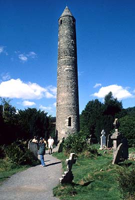
The graceful round tower rises on your right from an evocative tangle of tombstones. Easily the best ruins of Glendalough gather within 100 yards of this famous 110-foot-tall tower. Towers like this (usually 60-110 feet tall with windows facing the four cardinal compass points) were standard in Irish monastic settlements. They functioned as bell towers, storage lofts, beacons for pilgrims, and last-resort refuges during Viking raids. (But given enough warning, monks were safer hiding in the surrounding forest.) The towers had a high door with a pull-up ladder—both for safety and because a door at ground level would have weakened the tower’s foundation.
Several ruined churches (10th-12th century) lurk nearby...seek them out:
The cathedral (on your left as you face the round tower) is the largest and most central of all the ruins. Head “inside” the partial walls to get oriented. The church evolved over time with various expansions and through the reuse of stones from previous structures. The larger nave came first, and the chancel (up the couple of stairs where the altar later stood) was an addition. The east window faces toward Jerusalem and the rising sun, symbolic of Christ rising from the dead. Under the southern (right) window is a small wall cupboard with a built-in basin. The holy vessels used during Mass were rinsed here so that the holy sacramental water would drain directly into the ground, avoiding any contamination.
Around the far side of the cathedral is St. Kevin’s Cross. At 10 feet tall and carved from a single block of granite, this cross was a statement of utter devotion. (Most other famous Irish high crosses were carved of softer sandstone, allowing their carvers to create more ornate depictions of biblical stories than you’ll see here.) According to legend, if you hug this cross and can reach your hands around to touch your fingers on the other side, you’ll have your wish granted (and your jealous friends labeling you a knuckle dragger). St. Kevin: the patron saint of dislocated shoulders.
Straight ahead from the cross is the tiny priests’ house, which was completely reconstructed (using the original stones) from a 1779 sketch. It might have originally acted as a kind of treasury, housing the relics of St. Kevin.
On the left (downhill) as you face the priests’ house is perhaps the prettiest structure surviving on the site: St. Kevin’s “kitchen” (actually a church). Its short round tower appeared to earlier visitors to be a chimney, but its function was always as a belfry. The steeply stacked stone roof conceals a croft (upper story) perhaps used as a scriptorium for copying holy manuscripts. Nearby is the less impressive stone footprint of St. Kieran’s Church, possibly dedicated to the saint and contemporary of St. Kevin who founded Clonmacnoise Monastery (another scenic sanctuary, on the banks of the River Shannon south of the town of Athlone).
Continue to the bottom of the hill and cross the bridge over the brook. On the other side, you can either head left to go back to the visitors center and parking lot, or turn right on Green Road to explore the parklands.
Lakes and Parklands: The lovely, tree-shrouded Green Road leads to the lower lake. If you like, continue for a half-mile to the upper lake as part of a pleasant one-mile loop. The upper lake has a grassy lakeside picnic area and is sometimes filled with school groups. From here, you can walk back to the visitors center along the trail that parallels the public road. You can also drive to the upper lake (narrow road, pay parking).
The oldest ruins—scant and hard to find—lie near the upper lake. St. Kevin’s Bed is a cave where the holy hermit-founder of the monastery took shelter. It lies above the left (southern) shore and is visible and reachable only by boat. The story goes that St. Kevin’s devotion was so strong that he would strip off his clothes and jump into thornbushes rather than submit to the pleasures of the flesh. Another tale has him standing in pious stillness with arms outstretched while a bird builds its nest in his hand.
If you want a scenic Wicklow walk, begin here. Nine trails of varying lengths run through the lush Wicklow countryside (the longest loop takes four hours). The visitors center can offer advice; there’s also a national park office at the upper lake.
Irish National Stud
Ireland’s famed County Kildare—just west of Dublin—offers the perfect conditions for breeding horses. Its reputation dates all the way back to the 1300s, when Norman war horses were bred here. Kildare’s grasslands lie on a bedrock table of limestone, infusing the soil with just the right mix of nutrients for grazing horses. And the nearby River Tully sparkles with high levels of calcium carbonate, essential for building strong bones in the expensive thoroughbreds (some owned by Arab sheikhs) raised and raced here.
In 1900, Colonel William Hall Walker bought a farm on the River Tully and began breeding a line of champion thoroughbreds, mixing the local “hunter” horse with Arabian bloodlines—all guided by his astrological beliefs. His bizarre methods—and remarkable success—were the talk of the sport. In 1916, the colonel donated his land and horse farm to the British government, which continued breeding horses here. The farm was eventually handed over to the Irish government, which in 1945 created the Irish National Stud Company to promote the thoroughbred industry. Today, while nationalized, it generates a profit for taxpayers rather than costing them a dime.
Every Irish town seems to have a betting shop for passionate locals who love to closely follow (and wager on) their favorite horses. A quick glance at the weekend sports sections of any Irish newspaper gives you an idea of this sport’s high profile. Towns from Galway to Dingle host annual horse races that draw rabid fans from all over. Interestingly, Irish horse races run the track clockwise (the opposite direction from races in the US).
The five most prestigious Irish races take place at the Curragh Racecourse, just south of Kildare town (March-Oct, 1 hour west of Dublin, 10 minutes from the National Stud, www.curragh.ie). Horses have been raced here since 1741. The broad, open fields nearby are where the battle scenes in Braveheart were filmed (the neighboring Irish army base provided the blue-face-painted extras).
Today, a guided tour of the grounds at the Irish National Stud and a visit to the high-tech Irish Racehorse Experience offer a deeper appreciation for the amazing horses that call this place home. Get used to the euphemism “covering” to describe the purpose of this facility: to pair off promising specimens and convince them to...get romantic.
Animal lovers and horse-racing enthusiasts driving between Dublin and points west can enjoy a couple of hours here, combining the tour with a stroll through the gardens. While enjoyable any time of year, it’s best in the spring and early summer, when everything’s in bloom and you’ll see lots of mares and foals.
GETTING THERE
From M-7, drivers take exit #13 and follow the signs five minutes south (don’t take exit #12 for the Curragh Racecourse). By public transportation, it’s trickier: Trains departing Dublin’s Heuston station stop at Kildare town (45 minutes), while buses from Dublin’s Busáras station go to the Kildare Village shopping center; from either, it’s a long walk or a short taxi ride to the sight.
ORIENTATION TO IRISH NATIONAL STUD
Cost: €20, €18 off-season, cheaper online, includes guided tour plus entry to the Irish Racehorse Experience, Japanese Garden, and the rest of the grounds.
Hours: Daily 9:00-18:00, off-season from 10:00, closed mid-Dec-Jan, last entry one hour before closing; 45-minute tours run 6/day in summer, fewer off-season—check website for current times; +353 45 521 617, www.irishnationalstud.ie.
Eating: There’s a decent cafeteria with outdoor seating facing the Japanese Garden.
VISITING THE IRISH NATIONAL STUD
There are two main parts to your visit: the tour of the facilities and grounds, and the Irish Racehorse Experience interactive exhibit. You can do them in any order—staff can advise you what works best for the day’s schedule. Leave time to stroll through the charming Japanese Garden as well.
Guided Tour: The tour introduces you to some statues honoring both William Hall Walker and some of the farm’s famous horses. Then you step into the Sun Chariot Yard (named for the winner of the 1942 Fillies Triple Crown), surrounded by stables housing pregnant mares. The adjacent Foaling Unit is where births take place, usually from February through May. A typical year can see anywhere from 250 to more than 350 foals born here. The gestation period for horses is 11 months, with 90 percent of foals born at night. (In the wild, a mare and her foal born during the day would have been vulnerable to predators as the herd moved on. Instead, horses have adapted so that foals are born at night—and are able to keep up with the herd within a few hours.)
You’ll pass the Covering Shed (where the magic happens), then check out the Stallion Boxes, where you’ll learn how stargazing Colonel Hall Walker installed skylights in the stables—allowing the heavens maximum influence over the destiny of his prized animals. The eccentric Colonel sold those born under inauspicious astrological signs (regardless of their parents’ stellar racing records). A brass plaque on the door of each stall proudly states the horse’s name and racing credentials.
From here, you’ll walk past the Stallion Paddocks, for (distant) views of the current stars. These literal studs “cover” about 100 mares over the course of one season, and as many as four per day. (In the winter, the best are flown to Australia to participate in the “covering season” down under.) Among these big-name racehorses, you’ll also be introduced to the one called “Tommy the Teaser.” This unlucky horse’s job is to confirm that the mare is in heat before introducing the prime stallion...who then takes over.
You’ll end up at the Kildare Yard, then loop back along the pleasant tree-lined Tully Walk. You’ll likely see mares and foals running free, with the occasional cow thrown in for good measure (cattle have a calming effect on rowdy horses). To ensure you come home with all your fingers, take full note of the Horses Bite and Kick signs. These superstar animals are bred for high spirits—and are far too feisty to pet. The last paddock—closest to the Irish Racehorse Experience—is home to “Living Legends”: retired racehorses who’ve been gelded and sent here to live out their days.
On the opposite side of the Tully Walk is St. Fiachra’s Garden, named for the patron saint of gardening—enjoyable for a stroll after your tour. (The beehive-shaped stone huts you’ll see, while typical of Ireland, are modern replicas.)
Irish Racehorse Experience: This fun, modern, interactive exhibit vividly illustrates all aspects of Ireland’s obsession with horses and is an ideal complement to the tour (which conveniently ends here). After watching a brief introductory film, you’ll wander exhibits about the breeding and biology of the horses (a video shows a foal being born), the impressive physiology of the horses (a bellows simulates their impressive lung capacity, and you can try to lift a replica of a gigantic racehorse heart), the culture of jockeys (who, it’s said, must have a “touch of madness”), a primer on betting rules and quirks, and a rundown of some of the beloved commentators who call the races. Visitors are also given a tablet, which you use to purchase, name, train, and outfit a virtual racehorse of your own. As a grand finale, you’ll mount a faux-thoroughbred and hang on tight for a simulated race—bobbing up and down and feeling the wind in your face.
Rest of the Farm: Before leaving, make sure to walk through the tranquil and photogenic Japanese Garden, designed by a Japanese gardener brought over by the Colonel (who had a wide variety of interests) to depict the trials of life...beware the Tunnel of Ignorance. The garden is easy to miss—the entrance is hiding just past the café (you’ll need to scan your ticket)—but worth a stroll to enjoy the gurgling streams, red bridge, tea pavilion, and dreamy escape.
NEARBY: ROCK OF DUNAMASE
At this “poor man’s Cashel,” a 20-minute drive past the Irish National Stud (on the way to Kilkenny or Cashel), you can scramble over evocative remains of a once-great castle and enjoy views over the green countryside with few other tourists in sight. Likely inhabited since the ninth century, this hilltop was fortified with a stone fortress in the late 12th century. Today, you’ll walk up a gravel path under the round barbican tower, then up through the outer courtyard to the inner courtyard and the half-ruined great hall at the top—with sweeping views over County Laois. Free, always open, and easy to conquer, it’s worth a 15-minute scramble in good weather for those seeking a queen- or king-of-the-mountain feeling.
Getting There: From M-7, use exit #16; at the roundabout, follow L-7830 (labeled for Ballycarroll). Take this narrow country road for about 1.5 miles, and you’ll begin to see the hill-capping castle ruin straight ahead. Watch on the right for the turn-off, and park near the stone church; the trail up is directly opposite.