THE RING OF KERRY
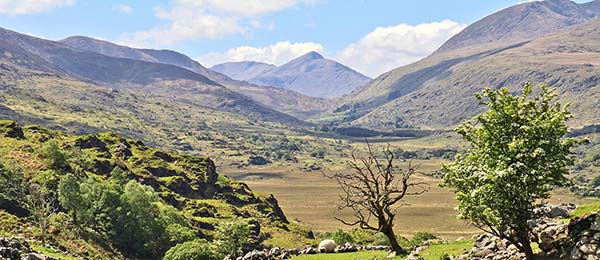
It’s no wonder that, since Victorian times, visitors have been attracted to this dramatic chunk of Ireland. Mysterious ancient ring forts stand sentinel on mossy hillsides. Early-Christian hermit-monks left a lonely imprint of their devotion, in the form of simple stone dwellings atop an isolated rock crag far from shore...a holy retreat on the edge of the then-known world. And beloved Irish statesman Daniel O’Connell maintained his ancestral estate here, far from 19th-century politics.
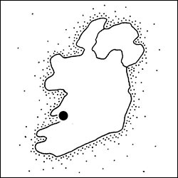
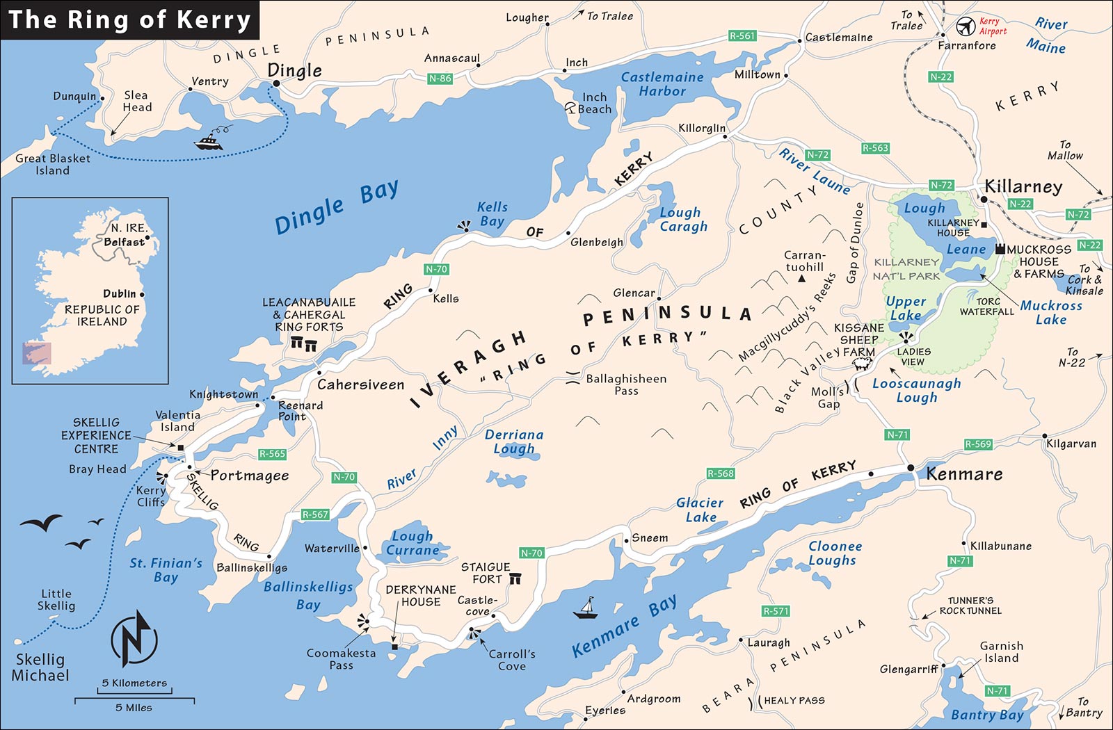
Today, it seems like every tour bus in Ireland makes the ritual loop known as the Ring of Kerry around the scenic Iveragh (eev-er-AH) Peninsula, using the bustling and famous tourist town of Killarney as a springboard. Killarney National Park is gorgeous and well worth driving through. But I prefer to skip Killarney town (useful only for its public transportation connections). Instead, make the tidy town of Kenmare your home base for your peninsula drive.
The Ring of Kerry requires lots of driving—especially compared to the similar, and much shorter, Slea Head loop on the Dingle Peninsula (covered in the next chapter). Is it worth it? If you don’t mind all that driving, the Ring of Kerry, with great scenery and low-key sights, can be a memorable add-on to your itinerary. But if you’re in a rush or don’t want to spend that much time behind the wheel, the Ring of Kerry is skippable, as it’s redundant with other parts of Ireland. And though Kenmare is a fine little town, it’s only worth visiting if you’re using it as a home base for the Ring of Kerry.
If I had to choose one spot to enjoy the small-town charm of traditional Ireland, it would be Dingle and its history-laden scenic peninsula, especially the Slea Head loop drive. But the Ring of Kerry—a much bigger, more famous, and more touristed peninsula just to its south—is also satisfying. Here’s a quick comparison:
Both peninsulas come with a scenic loop drive with lots of megalithic wonder. The main difference: Dingle’s is 30 miles. The Ring of Kerry loop is about 135 miles. Dingle’s prehistory is more intimate, with numerous little evocative stony structures. The Ring of Kerry’s prehistory shows itself in three massive ring forts—far bigger than anything on Dingle. (If you’re seeing other, similar ring forts—such as Caherconnell in the Burren, described on here, or Grianan of Aileach outside Derry in County Donegal, described on here, those on the Ring of Kerry are redundant.)
Dingle town is the ideal little Irish burg—alive with traditional music pubs, an active fishing harbor, and the sturdy cultural atmosphere of an Irish-speaking Gaeltacht region. You can easily spend three fun nights here. Kenmare (the best base for the Ring of Kerry loop) is pleasant but forgettable.
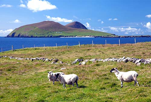
Both peninsulas have offshore islands that tempt travelers: Near Dingle, the heather-and-moss-covered Great Blasket Island and the excellent Blasket Centre museum (on the mainland) offer insights into the storytelling traditions and simple lives of hardy fisherfolk who lived here until the 1950s. Off the tip of the Ring of Kerry, Skellig Michael is a brutally rugged and remote chunk of rock in the Atlantic with evocative medieval stone ruins of its long-gone hermit-monks. It’s a world-class sight, but trickier to reach (you’ll have to stay in humdrum Portmagee or nearby, at the tip of the Ring of Kerry, as a base for the excursion...and hope for good weather).
Two fine sights are on the eastern/inland side of the Ring of Kerry (near Killarney); these are a natural add-on for those doing the Ring of Kerry and can be worth a detour even if you’re heading to Dingle: Muckross House, with its fascinating open-air farmhouse museum and beautiful lake views of Killarney National Park, and the fun working sheepdog demonstrations at Kissane Sheep Farm.
Both regions offer memorable scenery, warm B&B hospitality, and similar prices. With limited time, choose Dingle. With extra time, the Ring of Kerry is also a delight.
PLANNING YOUR TIME
You have several options for including the Ring of Kerry in your itinerary. If coming from Kinsale, the most reasonable choice is to spend one night in Kenmare. This lets you have a leisurely day of visiting sights near Killarney on your way to Kenmare, enjoy an evening in that small town, and spend the next day following my Ring of Kerry Drive. With less time and a willingness to endure a long, full day of driving, it’s also possible to begin in Kinsale, do my Ring of Kerry Drive, and make it to Dingle that night. I’ve outlined both options below.
Note: These plans assume you’re starting in Kinsale; if you’re coming from Kilkenny, add about 1.5 hours to reach the Ring.
Sane and Sensible Two-Day Plan, Overnighting in Kenmare
Day 1
Day 2
Head out on the Ring of Kerry loop, following my driving tour. Early birds who want to make all of the stops won’t regret hitting the road by 8:30 or so, to avoid the worst of the oncoming bus traffic; but you can make it work with a later departure, too. Skim through my “Planning Your Drive” tips on here and decide in advance which stops you want to make, to decide how early you should begin. In the afternoon, continue directly to Dingle; allow about two hours from Portmagee, and slightly less from the Cahergal and Leacanabuaile ring forts near Cahersiveen.
Packed One-Day Plan from Kinsale to Dingle
This ambitious plan covers a lot of miles and a lot of scenery, and prioritizes what I feel are the best stops. It’s a long day (figure about six hours of driving total, plus sightseeing stops and photo breaks), and you must be selective about where you stop. But it’s efficient and doable.
Itinerary Considerations
When making your plans, consider the following factors:
Visiting Kissane Sheep Farm: This farm’s wonderful working sheepdog demos are one of the highlights of this region, but the schedule is unpredictable. About a week in advance, check the schedule on their website. If the demo is in the afternoon, it’s easy to stop there on your way from Muckross House to Kenmare. If it’s midmorning, consider skipping Muckross, or overshooting Muckross to get to the sheep farm and backtracking later. (Kissane Sheep Farm is only about 20 minutes beyond Muckross House, but afternoon traffic in this area can be heavy.)
Avoiding Bus Traffic: Be aware of the column of big bus tours that begin arriving in the Killarney area in the early afternoon (coming from Kenmare—in the opposite direction you’re traveling). Because buses have the right-of-way, and there are stretches of narrow road, you may occasionally have to back up and pull over. For more on this, see the “Planning Your Drive” section on here.
Skipping Killarney: If you have no interest in Muckross House and Farms, Killarney National Park, and Kissane Sheep Farm, just head straight to Kenmare from Kinsale, skipping the detour up to Killarney. (Instead of staying on N-22 to Killarney, you’ll branch off onto R-569 a couple of kilometers after you cross the border from County Cork into County Kerry.) This saves about 40 minutes of driving but misses some beautiful scenery in the national park.
Side-Tripping to Skellig Michael: Hardy hikers might consider adding another day to visit the rugged island of Skellig Michael (described at the end of this chapter); to do that, it’s best to overnight in Portmagee or St. Finian’s Bay so you can easily catch the boat, which leaves in the morning. Be aware that boats can book up months in advance, and weather can cancel boat crossings. While the island is complicated to reach and adds time to your itinerary, it’s a highlight for many visitors. If you’d like to see Skellig Michael but you’re OK not landing on it, consider building in time on your Ring drive to take the afternoon boat trip that cruises around the Skellig islands.
Killarney and Nearby
I much prefer smaller, more charming Kenmare as a home base, but the bigger town of Killarney is the hub from which most visitors approach this region. While I recommend skipping right through Killarney itself—which is essentially one big open-air shamrock shopping mall—several worthwhile sights are located outside the town, on the road to Kenmare. The excellent Muckross House and Farms are within Killarney National Park, a forests-and-mountains landscape that’s one of the most beautiful noncoastal corners of County Kerry, while Kissane Sheep Farm, with its fascinating sheepdog demonstration, is just outside the park.
KILLARNEY
Killarney (pop. 15,000) is a household word among American tourists, and it seems to be on every big bus tour itinerary. Springing from the bus and train stations of this thriving regional center are a few colorful streets lined with tourist-friendly shops and restaurants. Killarney’s suburbs sprawl with vast hotels that, except for the weather, feel more like Nebraska than Ireland. Killarney’s elegant Neo-Gothic church stands tall, as if to say the town existed and mattered long before tourism. But then you realize it dates from 1880...just about when Romantic Age tourism here peaked. For nonshoppers, Killarney’s value is its location at the doorstep of the lush Killarney National Park. And for most tour organizers, it’s the logical jumping-off point for excursions around the famous Ring of Kerry peninsula.
If you’re traveling in the region without a car, you’ll have to stop here. The Killarney bus and train stations flank the big, modern Killarney Outlet Centre mall. (In some touristy parts of Ireland, like this one, every other shopping center is called an “outlet”—implying factory-direct values.) If you have a layover between connections, walk five minutes straight out from the front of the mall, and check out Killarney’s shop-lined High Street and New Street.
The TI is a 15-minute walk from the train station (on Beech Street, +353 64 663 7928, https://killarney.ie). There’s also a flashy national park information center, with various films and interactive exhibits, at Killarney House in the center of town; it’s not worth a detour unless you want to delve into the park’s natural history or you have detailed questions on hiking (+353 1 539 3620, www.nationalparks.ie/killarney).
Killarney Connections
By Bus to: Kenmare (3/day, 45 minutes), Tralee (hourly, 40 minutes), Dingle (5/day with change in Tralee, 2.5 hours), Shannon Airport (4/day with change in Cork, 3 hours), Dublin (4-5 per day, 6 hours, change in Limerick). The bus station has a left-luggage desk. Bus info: www.buseireann.ie.
By Train to: Tralee (8/day, 35 minutes), Cork (every 2 hours, 2 hours, most with change in Mallow), Waterford (5/day, 4-6 hours), Dublin (every 2 hours, fewer on Sun, 3.5 hours, 1 direct in morning, rest with change in Mallow). Train info: www.irishrail.ie.
To Muckross House: There’s no bus service. You can hike 30 minutes (get directions from TI), rent a bike, hire a horse buggy, or catch a cab.
To Ring of Kerry: Several companies offer reasonably priced private bus tours from Killarney; check the latest options online, or ask at the TI.
SIGHTS NEAR KILLARNEY
My best advice to those in Killarney: Get out of town. Heading south on N-71, the sprawl of Killarney gives way almost immediately to a beautiful green landscape; from here, the natural beauty increases dramatically for about 14 miles (23 km) to Moll’s Gap, then gently downshifts as you work your way downhill to lovely, low-key Kenmare.
Officially, this is the first leg of the scenic Ring of Kerry. I’ve linked these sights with driving directions. My coverage of Killarney National Park assumes a quick look on your drive through. But if you have more time, there are many fine, scenic ways to spend it, including some pretty nature walks, demanding hikes, and boat trips on the many lakes. More information is available at Killarney House in town or at the information kiosk on the grounds of Muckross House.
• From Killarney, head 3 miles (5 km) south on N-71. Through the trees, you’ll enjoy peekaboo views on your right over Lough Leane. Partway to Muckross House, you’ll see a small parking lot used by horse-and-buggy bandits to hoodwink tourists into thinking they have to pay to clip-clop to the house. Pass by, travel another mile or so to the actual turnoff on the right, and find a big, safe, and free parking lot.
▲Muckross House and Farms
Perhaps the best stately Victorian home you’ll see in the Republic of Ireland, Muckross House (built in 1843) is magnificently set at the edge of Killarney National Park. Across the lawn and parking lot is Muckross Farms, a fascinating open-air farm museum that shows rural life in the 1930s. The juxtaposition of the magnificent mansion and the humble farmhouses illustrates in a thought-provoking way the vast gap that once separated rich and poor in Ireland.
Cost and Hours: House or farms—€7 each, €12 combo-ticket for both (Heritage Cards not accepted for farms); house open daily 9:00-18:00, July-Aug until 19:00, last entry 80 minutes before closing; farms open daily June-Aug 10:00-18:00, May and Sept from 13:00, March-April and Oct Sat-Sun only 13:00-18:00, closed Nov-Feb, last entry one hour before closing; just south of Killarney on N-71; +353 64 667 0144, www.muckross-house.ie.
Background: A visit here takes you back to the Victorian period—the 19th-century boom time when the sun never set on the British Empire and the Industrial Revolution (born in England) was chugging the world into the modern age. Of course, Ireland was a colony back then, with big-shot English landlords. During the Great Potato Famine of 1845-1849, most English gentry lived very well—profiting off the export of their handsome crops to lands with greater buying power—while a third of Ireland’s population starved. Compared to many fine mansions, Muckross House feels less ostentatious and more lived-in (and it was, until 1933). Its fine Victorian furniture is arranged around the fireplace under Waterford crystal chandeliers and lots of antlers.
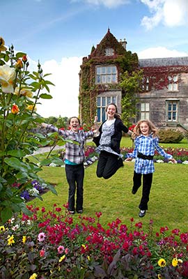
Visiting the House and Farms: The parking lot embraces a central green area with a handy information kiosk that dispenses advice on visiting the national park. On one side, you’ll see the modern building of the Muckross Craft Centre—a big shop with an industrial-strength $ cafeteria. The Muckross House is near the Craft Centre (to the right as you face it), and the Muckross Traditional Farms are across the parking-lot crescent.
Muckross House: Buy your ticket in the courtyard, then enter the house and follow the one-way route. (In the past, guided tours made this house more meaningful; if these resume, it’s worth joining one.)
Begin upstairs, with several fine, well-antlered rooms designed for hosting guests: the dining room, the library, the drawing room, and the main hall (with an attached billiard room). From there, head upstairs and explore a series of smaller bedrooms and living spaces.
Back down on the ground floor is a bedroom prepared for Queen Victoria. (Notice an additional fire escape installed outside her window, since she was afraid of house fires.) The owners of the house spent a couple of years preparing for the royal visit in 1861, eager to gain coveted titles and nearly bankrupting themselves in the process. The queen stayed only three nights, and her beloved Prince Albert died soon after the visit. The depressed queen never granted the titles that the grand house’s owners had so hoped for.
Finally, head down to the cellar, with the room where servants socialized and waited to be called upon. Notice more than 30 bells strung near the ceiling along the hallway; each had a different sound, so the servants would know precisely where they were needed. The rest of the cellars feature various storage rooms and the kitchen.
Near the house, you can explore the gardens.
Muckross Traditional Farms: Across the grassy field from the mansion, a variety of vintage buildings are strung along a mile-long loop; a free shuttle bus runs about every 15 minutes for those who don’t want to hike.
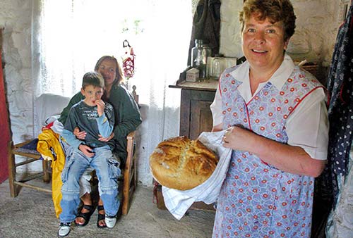
The loop begins with three farms a few minutes’ walk apart: Small Farm, Medium-Sized Farm, and (wait for it) Large Farm. At each one, you’ll step into an antique farmhouse where local docents are eager to tell you more. The farm visits are a great experience—but only if you engage the attendants in conversation. They enjoy talking about farm life in the old days—from the 1920s until electricity arrived in 1955. When farmers here first got electricity, they’d pull on rubber Wellington boots for safety and nervously “switch it on.” Poor farmers could afford electricity only with the help of money from relatives in America. They’d have one bulb hanging from the ceiling and, later, one plug for a hot pot. Every table had a Sacred Heart of Jesus shrine above it; the plug went directly below it. No one dreamed of actually heating the house with electricity. Children slept six to a bed, “three up and three down...feet in your face.” You’ll learn what happened when you had the only radio in the area, and how one flagstone on the mud floor was enough for the fiddler and dancer to set the beat.
Completing the loop is a hardworking little corner of the property, with a bridlemaker, carpenter, and blacksmith. Finally, the schoolhouse offers a glimpse into education in the olden days.
• From Muckross House, continue driving south on N-71, and buckle up for an especially scenic stretch through the park.
▲Killarney National Park Drive
This 25,000-acre park (Ireland’s oldest) was established when Muckross Estate was donated to the nation in 1932. Walking trails attract hikers of all levels for views of flora and fauna. Glacially sculpted rock ridges cradle three large lakes teeming with trout and salmon, which lure sport fishers. The park offers a window on the Ireland of 8,000 years ago, before Neolithic people settled here and began rudimentary slash-and-burn farming. Later English colonial harvesting of timber accelerated the deforestation process. Today, while famously green with pastures, Ireland has the smallest proportion of forested land—10.5 percent—of any EU nation. The park’s old-growth oak, yew, and alder groves are the best preserved in Ireland, and rhododendrons explode beside the road in late May and June. If you visit early or late in the day, keep an eye out for Ireland’s only native herd of red deer.
From Muckross House, it’s just 2 miles (3 km) to a small parking lot for Torc Waterfall. You can enjoy an easy 10-minute stroll to the waterfall along a trail bordered by mossy rocks. Hikers will find more strenuous trails beyond.
Soon after, you’ll drive along Muckross Lake—also known as the Middle Lake. In addition to all those forests and mountains, one-quarter of the national park is made up of lakes. This one connects with the largest, Lough Leane (or the Lower Lake), at a place west of here called the Meeting of the Waters.
Next you’ll twist up into a rocky landscape and pass yet another lake—the Upper Lake—as well as tributaries of the River Owengarriff, offering picturesque roadside views. Midway along the Upper Lake, the road narrows through a one-lane tunnel, carved out of the rock. Yield to any buses you encounter, as they have the right-of-way. (Bus traffic, which travels in the opposite direction you’re headed, is heavier in the afternoon, as they return from their day trips.)
You’ll follow the lake for a short spell, then hit another twisty segment. Farther along, the road bends as you cross a bridge at a minuscule settlement called Derrycunihy (at an old stone church). This tight stretch tends to be another bottleneck, where cars and buses do a delicate do-si-do to get everyone through.
Less than a mile past Derrycunihy, you come to the panorama point called Ladies View, a good spot for expansive views over the lakey landscape. It’s named for Queen Victoria’s ladies-in-waiting; during an 1861 visit, they paused here for a picnic and were overwhelmed by the views. This is supposedly one of the most photographed vistas in all of Ireland; while it’s nice, that says as much about the outsize popularity of the Ring of Kerry as anything.
Driving on, you officially exit the park—but the scenery doesn’t let up. You’ll pass long, thin Looscaunagh Lough (beside the road on the left). A few hundred yards farther, the Black Valley opens up beneath you on the right. This remote valley was the last chunk of Ireland to get electricity—in 1978. The highest bump on the distant ridge across the Black Valley to the west is Carrantuohill, Ireland’s tallest mountain at 3,400 feet. This is part of the island’s highest mountain range, adorably called Macgillycuddy’s Reeks.
• High up here in the middle of nowhere, on a rocky mountaintop, watch on the right for...
▲▲Kissane Sheep Farm
The best working sheepdog demonstration I’ve seen is at this 2,500-acre Irish farm, perched on a dramatically scenic, rocky slope above the Black Valley. The Kissane family has raised sheep here for five generations. John (or his brother Noel) explains first the sheepherding, then the sheep shearing. The highlight is the demonstration of sheepherding by the supremely alert border collies who have trained here since puppyhood. John (or Evan) commands the dogs from afar using an array of verbal calls, whistles, and hand signals. Then you head inside to watch the sheep-shearing process. Touching the pile of fresh wool afterward, you can feel the lanolin, which acts as natural waterproofing for the sheep and is extracted from the wool to sell to pharmaceutical firms (synthetic manufacturing has driven the price of wool so low, it’s not worth selling otherwise). Sheep shearing takes place from mid-May to early October; spring visitors will also see newborn lambs. These days the farm makes more money from tourists than it does in the traditional sheep-and-wool trade.
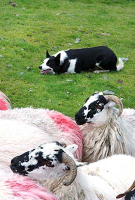
Cost and Hours: €8; demonstrations run most days April-Oct, check their user-friendly website for schedule, closed Sun and Nov-March; as this is a working farm, please don’t just show up at other times or too early—guests are welcome 15 minutes prior to demo; on N-71 between Ladies View and Moll’s Gap, +353 64 663 4791, mobile +353 87 260 0410, www.kissanesheepfarm.com, noel@kissanesheepfarm.com.
• Beyond the sheep farm is the summit of this road: Moll’s Gap (WCs and Avoca Café beside parking lot). From here, twist sharply down into Kenmare. The rugged, bare rock on either side of the road was rounded and smoothed by the grinding action of glaciers over thousands of years. In the distance to the north (on your right) look for the Gap of Dunloe, a perfect example of a U-shaped glacial valley notch.
Kenmare
Cradled in a lush valley, this charming little town (known as Neidín, “Little Nest,” in Irish) hooks you right away with its rows of vividly colored shop fronts and go-for-a-stroll atmosphere. The nearby finger of the gentle sea feels more like a large lake (called Kenmare Bay, or sometimes Kenmare River, just to confuse things). Far from the assembly-line tourism of Killarney town, Kenmare (rhymes with “been there”) also makes a great launchpad for enjoying the sights along the Ring of Kerry.
Other than aimless strolling, there’s not much to do in Kenmare: Check out the Heritage Centre in the back rooms of the TI to get an overview of the region’s history. Visit the Kenmare Lace and Design Centre above the TI for an up-close look at the town’s famously delicate lace. A five-minute walk from the TI gives you hands-on access to a prehistoric stone circle at the edge of town. Finish up by taking a peek inside Holy Cross Church to see the fine ceiling woodwork.
Orientation to Kenmare
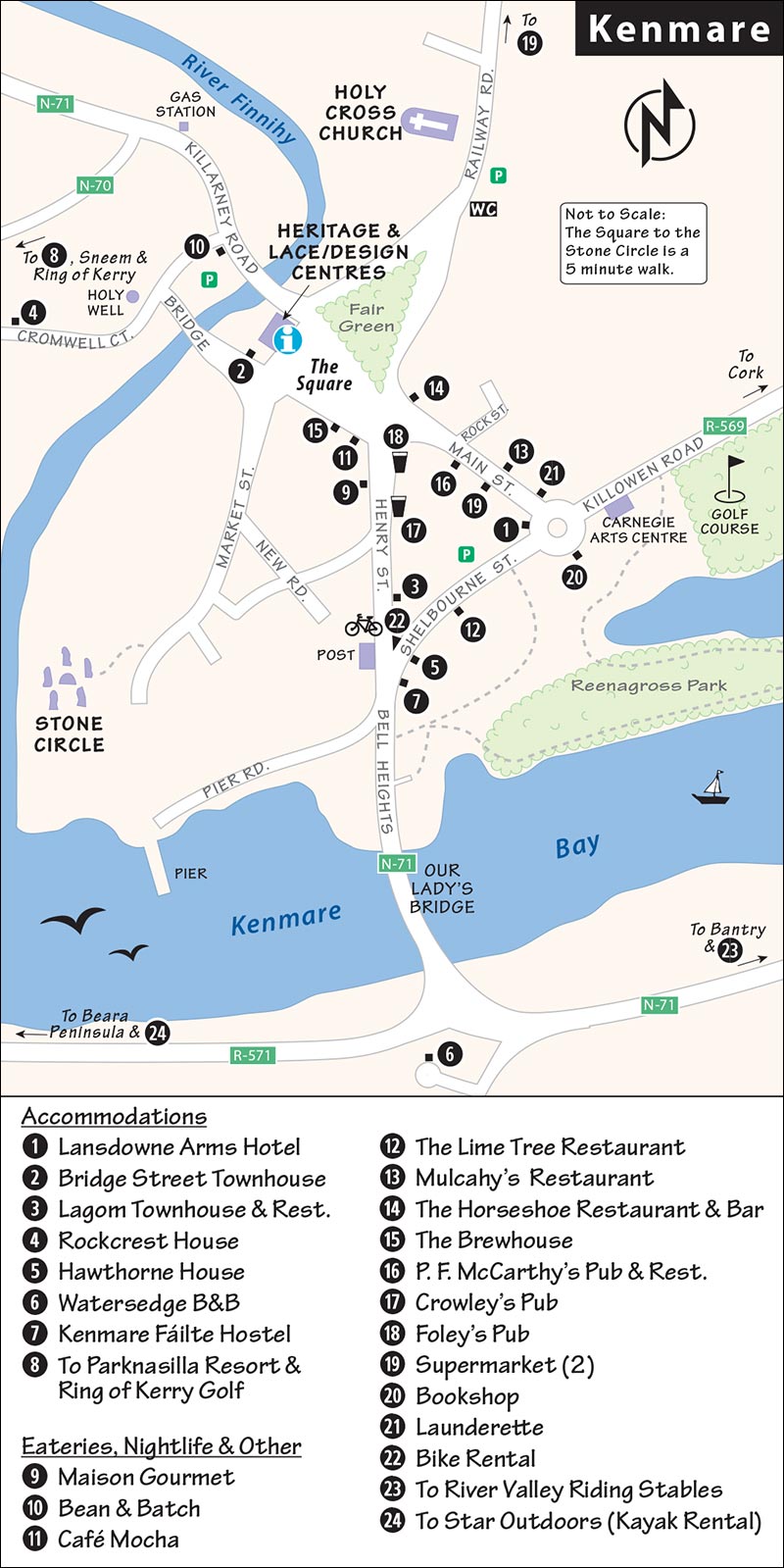
Carefully planned Kenmare (pop. 2,500) is shaped like an “X,” forming two triangles. The upper (northern) triangle contains the town square—where fairs and markets have been held for centuries (colorful market Wed in summer), the adjacent TI and Heritage Centre, and a cozy park. The lower (southern) triangle contains three one-way streets busy with shops, lodgings, and restaurants. Use the tall Holy Cross Church spire to get your bearings (next to the northeast parking lot, handy public WC across the street).
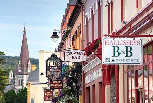
Tourist Information: The helpful TI is right on the town square (Tue-Sat 9:00-13:00 & 14:00-17:00, closed Sun-Mon, www.discoverireland.ie or www.kenmare.ie).
HELPFUL HINTS
Bookstore: Kenmare Bookshop is a cozy one-room cottage run by friendly John O’Connor (Mon-Sat 10:00-13:00 & 14:00-17:30, Sun 13:00-17:00, maybe later in summer, on Shelbourne Street at roundabout across from Lansdowne Arms Hotel, +353 64 664 1578).
Laundry: O’Shea’s Cleaners and Launderette offers self-service laundry, as well as Mon-Fri drop-off service (Mon-Sat 9:00-20:00, Sun 12:00-18:00; across from Lansdowne Arms Hotel on Main Street, hidden in back of O’Shea’s photography shop, +353 64 664 0808).
Bike Rental: Finnegan’s Corner rents bikes and has route maps and advice on maximizing scenery and minimizing traffic (daily, office in gift shop at 37 Henry Street, +353 64 664 1083, www.finneganscycles.com).
Taxi: Try Kenmare Coach and Cab (+353 87 248 0800) or Kenmare Tours & Travel (+353 87 243 8588).
Parking: Two large public parking lots (behind the TI and across from the church, free overnight) cling to the two main roads departing town to the north. Street parking is free (but time-limited).
Cultural Events: At the Carnegie Arts Center, you can attend concerts in its 140-seat theater, art exhibitions, and films (across Shelbourne Street from Lansdowne Arms Hotel, +353 64 664 8701, www.carnegieartskenmare.ie).
Tours in Kenmare
Walking Tours
Anne-Marie Cleary gives 1.5-hour walking tours of town (€12, daily at 10:30 in summer, must book in advance, +353 86 240 0484, www.kerrytourguides.com, info@kerrytourguides.com). She also offers half-day tours of Killarney, Garnish Island, and Bantry (€80) plus full-day tours of the Ring of Kerry and Beara Peninsula (from €110) and private tours (prices on request).
Bus or Private Car Tours
Finnegan’s Tours runs a variety of day tours around the Ring of Kerry and the Beara Peninsula with guides who provide historical narration along with the occasional song or story. Tours generally leave at 10:00 and return before 17:00 with plenty of stops (prices vary, inquire and reserve by phone or email, +353 87 248 0800, www.kenmarecoachandcab.com, info@kenmarecoachandcab.com).
Kerry Experience Tours offers custom tours of the Ring of Kerry and the Beara Peninsula (full-day tours start from about €350/day, +353 86 255 4098, www.kerryexperiencetours.ie, info@kerryexperiencetours.ie).
Sights in Kenmare
Heritage Centre
This humble museum, in the back rooms of the TI, consists of a series of storyboards and a model of the town. A 20-minute visit here explains the nearby ancient stone circle, the history of Kenmare’s lacemaking fame, and the story of a feisty, troublemaking nun (free, same hours as TI).
Kenmare Lace and Design Centre
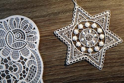
A single large room above the TI displays the delicate lacework that put Kenmare on the map. From the 1860s until World War I, the Poor Clare convent at Kenmare was the center of excellence for Irish lacemaking. Inspired by antique Venetian lace, nuns created their own designs and taught needlepoint lacemaking as a trade to girls in a region struggling to get back on its feet in the wake of the catastrophic famine. Queen Victoria commissioned five pieces of lace in 1885, and by the end of the century tourists began visiting Kenmare on their way to Killarney just for a peek at the lace. Nora Finnegan, who runs the center, usually has a work in progress to demonstrate the complexity of fine lacemaking to visitors.
Cost and Hours: Free; Mon-Sat 10:30-13:00 & 14:15-17:00, closed off-season and Sun year-round; +353 87 234 6998, https://kenmarelace.ie.
▲Ancient Stone Circle
Of the approximately 100 stone circles that dot southwest Ireland (Counties Cork and Kerry), Kenmare’s is one of the most accessible, and beautifully set—on a grassy hill, ringed by trees and hedges, overlooking a gurgling river. More than 3,000 years old, the circle has a diameter of 50 feet and consists of 15 stones ringing a large center boulder (possibly a burial monument). Experts think this stone circle (like most) functioned as a celestial calendar—it tracked the position of the setting sun to determine the two solstices (in June and December). For more information on stone circles, see here. Nearby, the hawthorn “fairy trees” have wishes tied to their branches.
Cost and Hours: €2.50, drop coins into honor box in hut by entry when attendant is away, daily 8:30-20:30, open until dark in summer, closes earlier off-season.
Getting There: It’s a five-minute walk from the TI: In the town-center parking lot, face the TI, turn left, and walk 200 yards down Market Street, passing a row of cute 18th-century houses on your right. Beyond the row of houses, veer right through the gate with a brown Stone Circle sign and continue 50 yards down the paved road. You’ll pass the entry hut on your right.
Holy Cross Church
Kenmare’s grand Catholic church, finished in 1864, is worth a quick visit to see the ornate wooden ceiling supported by 10 larger-than-life angels (carved in Bavaria), the fine 1914 altar carved of Italian marble, and the Victorian stained-glass windows.
Experiences near Kenmare
Horseback Riding: River Valley Riding Stables offers day treks for all levels of experience through beautiful hill scenery in the Roughty River Valley (based at Sheen Falls Lodge 1.5 miles southeast of Kenmare—cross Our Lady’s Bridge and turn left on N-71, +353 87 958 5895, www.kenmare.com/rivervalleystables, rivervalleystables@hotmail.com).
Boating: Star Outdoors rents kayaks and can organize other water adventures. Reserve online or via phone (located 5 miles southwest of Kenmare on R-571 on Beara Peninsula, courtesy shuttle can pick you up in Kenmare, +353 64 664 1222, https://staroutdoors.ie).
Golfing: The Kenmare Golf Club offers a scenic day on the links, right on the edge of town (on R-569 toward Cork, +353 64 664 1291, www.kenmaregolfclub.com). Or try the Ring of Kerry Golf and Country Club (4 miles west of town on N-70, book ahead on weekends, +353 64 664 2000, https://ringofkerrygolf.com).
Nightlife in Kenmare
Wander the compact Kenmare town triangle and stick your head in wherever you hear something you like. Music usually starts at 21:30 (although some pubs have early 18:30 sessions—ask at the TI) and ranges from Irish traditional sessions to sing-along strummers. Crowley’s is an atmospheric little shoebox of a pub with an unpretentious clientele. Foley’s invites you in for a folksy songfest.
Sleeping in Kenmare
For locations of these places, see the “Kenmare” map, earlier.
$$$$ Lansdowne Arms Hotel is the town’s venerable grand hotel, with generous public spaces, including a piano lounge. This centrally located, 200-year-old historic landmark rents 28 large, crisp rooms (parking, corner of Main and Shelbourne streets, +353 64 664 1368, www.lansdownekenmare.com, info@lansdownekenmare.com).
This sleepy yet scenic wedge of land (just south of Kenmare) is worth considering if you have the luxury of two nights in Kenmare. Beara deserves honorable mention as a distant third choice after the Dingle and Ring of Kerry peninsulas, but locals rave about it like we would our home sports team. If you don’t have a full day to drive the length of it, spend a memorable half-day enjoying Garnish Island and Healy Pass, skipping the western half of the peninsula.
Garnish Island is a rocky island refuge cloaked by a lush garden and plopped down in the corner of Bantry Bay. Crowned by a martello tower (a stout bunker built to repel feared Napoleonic invasions, free to climb for views), the gardens were the creation of a rich landlord, who turned the barren 37 acres into a lushly vegetated fantasy in the early 1900s. You’ll meander past Italian reflecting pools, a Grecian temple framing views of a placid bay, and a walled garden nursery clad in roses. Pine-forested trails, punctuated with rhododendrons, connect it all. Boats depart from the well-marked pier in Glengarriff, about 18 miles (30 km) south of Kenmare, for the scenic 15-minute cruise past seals sunning on rocks to the island (boat—€16 round-trip, 2/hour; gardens—€5, daily 9:45-17:15, closed Nov-mid-March; tearoom, snacks, and WCs at island’s pier, enter P75 KA03 if using GPS, +353 27 63116, https://harbourqueenferry.com).
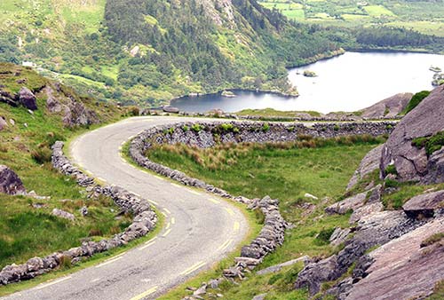
A narrow, eight-mile mountain road (R-574) feels like a toboggan run as it squiggles over the peninsula’s lumpy spine at Healy Pass. The road linked the north coast (County Kerry) to the south coast (County Cork) to facilitate food-relief deliveries 175 years ago. The views from the 1,000-foot summit make you marvel at the road-building skills of the famine-era workmen. The barren, rocky landscape makes it easy to spot approaching cars.
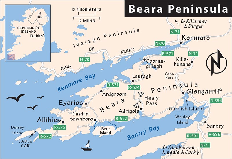
The rest of the peninsula is pastoral in the middle and edged with scenic cliffs near the tip. Ireland’s only cable car connects the headland with mellow Dursey Island. The car also transports cattle one at a time. The floor is slatted so water can be sloshed over the boards to wash out the dung. Castletownbere (on the south coast) is a fishing port with plenty of pubs for lunch. Allihies and Eyeries (on the north coast) are two of the most colorfully painted towns in Ireland, splattered with pastels and vivid hues.
$$$ Bridge Street Townhouse combines antique furniture with contemporary style in nine rooms. Opt for one of the “deluxe” rooms with a view to town or the river. Lucy (who’s a kick) prepares a fab breakfast, including sausage from her dad (a butcher with a shop downstairs) and honey from a neighbor (Bridge Street, +353 64 664 1534, www.bridgestreettownhouse.com, hello@bridgestreettownhouse.com).
$$$ Lagom Townhouse is all about “elevated simplicity,” with a high-end but minimalist Scandinavian aesthetic. Its 10 smallish rooms are themed after local flora and decorated with local crafts. Breakfast is in the recommended restaurant downstairs (36 Henry Street, +353 87 977 2310, www.lagomkenmare.com, info@lagom-kenmare.ie, Liz and Brendan).
$$ Rockcrest House is secluded down a leafy lane, a pleasant five-minute walk from the town center. They rent five large rooms and offer a fine front-porch view (cash only; as you pass the TI heading north out of town, take the first left after crossing the bridge; +353 64 664 1248, mobile +353 87 904 3788, www.visit-kenmare.com, info@visit-kenmare.com, Marian and David O’Dwyer). Ask about their two self-catering cottage rentals.
$$ Hawthorn House, a fine, modern, freestanding house with a lounge and 10 comfy rooms, is in a residential location just a block from all the pub and restaurant action. Warm and friendly hostess Mary O’Brien’s front parlor is an homage to her son Stephen’s success on the dominant County Kerry Irish football team (no breakfast, family rooms, parking, Shelbourne Street, +353 64 664 1035, +353 87 672 9735, www.hawthornhousekenmare.com, hawthornhousekenmare@gmail.com). Mary’s modern, self-catering apartment next door works well for those wanting to linger (weekly rentals).
$ Watersedge B&B is a mile south of town, serenely isolated on a forested hillside and overlooking the estuary. The modern house has four clean, colorful rooms and a kid-pleasing backyard (+353 87 413 4235, https://watersedgekenmare.ie, watersedgekenmare@gmail.com, Noreen and Vincent O’Shea). To get here, drive south over Our Lady’s Bridge, take the second right (watching for the B&B sign), go about 100 yards, and then—at the end of the white cinder-block wall (on left)—turn right onto the private lane and drive 100 yards to the dead-end. It’s worth it.
¢ Kenmare Fáilte Hostel (FAWL-chuh) maintains 34 budget beds in a well-kept, centrally located building (private rooms available, no breakfast, no public space, closed mid-Oct-April, Shelbourne Street, +353 87 711 6092, run by Finnegan’s Corner bike-rental folks directly across street, www.kenmarehostel.com, failtehostelkenmare@gmail.com).
SLEEPING IN LUXURY ON THE RING OF KERRY
$$$$ Parknasilla Resort is a 19th-century hotel with 85 rooms, lost in 500 plush acres of a subtropical park overlooking the wild Atlantic Ocean. With indulgent service and tranquil elegance that blends luxury and nature, this destination is a ritual splurge for Irish families and wedding groups. Activities include a heated oceanside pool, sea kayaking, guided walks, tennis, cycling, yoga, spa treatments, and golf (highest rates July-Aug, two-bedroom homes available, +353 64 667 5600, https://parknasillaresort.com, reservations@parknasillaresort.com).
Eating in Kenmare
This friendly little town offers plenty of quality dining options. Make a reservation or have dinner early, as many finer places book up on summer evenings. Pub dinners are a good value, but pub kitchens close earlier than restaurants. For locations, see the “Kenmare” map, earlier.
CASUAL LUNCH SPOTS
The following places are good for a casual or grab-and-go lunch.
$$ Maison Gourmet is a real-deal French patisserie and boulangerie, with salads, sandwiches, and decadent pastries (daily, 6 Henry Street, +353 64 664 1857).
$ Bean & Batch, on the road into town, is bustling each morning with locals and visitors here to get coffee and pastries or to pick up big, hearty sandwiches for a Ring of Kerry picnic (daily from 7:00, Killarney Road).
$ Café Mocha is a basic sandwich shop (daily, on the town square, +353 64 664 2133).
Supermarket: In the center you can stock up for a Ring of Kerry picnic at Murphy’s Daybreak (daily, Main Street). On the outskirts you’ll find a SuperValu (daily, Railway Road).
RESTAURANTS
$$$ The Lime Tree Restaurant occupies the former Lansdowne Estate office, which gave more than 4,000 people free passage to America in the 1840s. These days, it serves delicious, locally caught seafood dishes in a modern yet cozy dining hall (closed Tue-Wed, dinner only, Shelbourne Street, +353 64 664 1225, www.limetreerestaurant.com).
$$$$ Lagom, connected to the recommended hotel of the same name, is splurge-worthy, featuring inventive takes on classic Irish lamb, steak, and seafood dishes—and it has the best vegetarian offerings in town. Chef Brendan Byrne and family take inspiration from the Swedish concept of lagom, meaning (roughly) “not too much, not too little” (closed Sun-Mon, 36 Henry Street, +353 64 664 8423, https://lagomkenmare.com).
$$$ Mulcahy’s Restaurant has a jazz-mellowed, elegant vibe and creatively presented modern Irish dishes with subtle Indian, Japanese, and American influences (closed Sun, dinner only, Main Street, +353 64 664 2383, www.mulcahyskenmare.ie).
$$$ The Horseshoe Restaurant and Bar, specializing in steak, spareribs, and fish, somehow turns rustic farm-tool decor into a romantic candlelit sanctuary (daily, dinner only, 3 Main Street, +353 64 664 1553, www.thehorseshoekenmare.com).
$$ The Brewhouse’s outdoor seating on the town square draws a crowd when the sun shines (daily, +353 64 664 2357).
$$ P. F. McCarthy’s Pub and Restaurant feels like a sloppy saloon, offering reasonable salad or sandwich lunches and filling dinner fare, plus live music most evenings (closed Thu, 14 Main Street, +353 64 664 1516).
Kenmare Connections
Kenmare has few bus connections and no train station. Most buses transfer in Killarney. Bus info: www.buseireann.ie.
From Kenmare by Bus to: Killarney (3/day, 45 minutes), Tralee (3/day, 2 hours), Dingle (3/day, 3-4 hours, change in Killarney and Tralee), Kinsale (3/day, 4 hours, 2 changes).
For Dublin, take a bus to Killarney and transfer to a train.
Ring of Kerry Drive
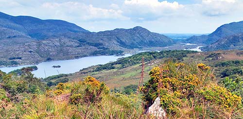
More than twice the size of the Dingle Peninsula and backed by a muscular tourism budget that promotes every sight as a “must-see,” the Ring of Kerry (Iveragh Peninsula) can seem overwhelming. Lassoed by a winding coastal road (the Ring), this mountainous, lake-splattered region comes with fine scenery. While a fleet of tourist-laden buses circles it each day, they generally depart Killarney around the same time, head the same direction, and stop at the same handful of attractions. If you avoid those places at rush hour, the Ring feels unspoiled and isolated, allowing its dramatic scenery to really shine.
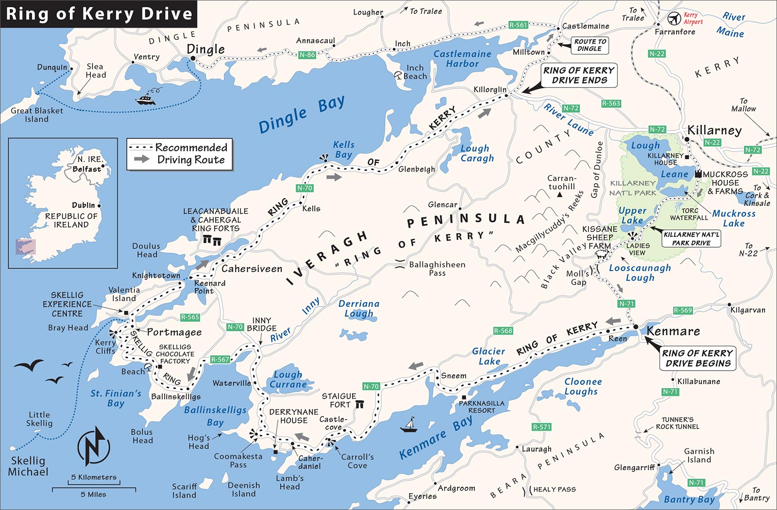
You can explore the Ring by car in one satisfying day. This drive covers the most scenic stretch: from Kenmare, out to the Skellig Ring, across Valentia Island, then along Dingle Bay to Killorglin. From there, you can head back toward Kenmare or on to Dingle. The flat, inland, northeastern section of the Ring—from Killorglin to Killarney on N-72—is skippable. The stretch from Killarney to Kenmare is described earlier in this chapter, under “Killarney and Nearby.”
PLANNING YOUR DRIVE
My Ring of Kerry Drive is about 90 miles and three hours of driving without stops. Factoring in time for lunch and sightseeing, the Ring is easily an all-day experience. Tank up before leaving Kenmare, as gas there is cheaper than out on the Ring.
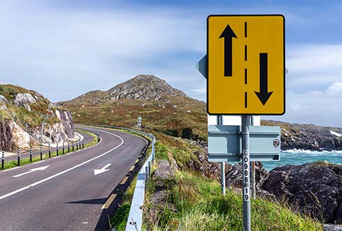
Driving Tips: I recommend driving clockwise around the Ring to avoid getting stuck behind a chain of tour buses (which are required to drive it counterclockwise). The catch here is that you’ll be passing buses going in the opposite direction—and there are several stretches where the road narrows and you may have to yield to oncoming traffic. Legally, buses have the right-of-way. Drive defensively and don’t drift into the center of the road, as you could encounter an oncoming bus at any turn. If there’s a bottleneck, you’ll need to back up to the nearest wide spot in the road to let the bus through. Fortunately, there are lots of scenic-view pullouts that make it easy to let a bus pass.
When to Begin: Getting an early start minimizes your encounters with oncoming buses. After years of driving the Ring, I’ve learned that if you leave Kenmare by 8:30 and shoot to reach Waterville by noon, you essentially miss all the buses—which rumble past on the main Ring while you’re exploring the sleepier Skellig Ring. Departing later is also workable, especially if you skip some of the early sightseeing stops—but you may encounter a few more bottlenecks later on.
Navigation: Wayfinding is pretty straightforward here. Brown Ring of Kerry signs mark the route (but be aware that my recommended Skellig Ring scenic detour requires an easy-to-miss turnoff from the main road just after Waterville—follow those directions carefully). The map in this chapter, plus freebies available locally, are good enough for most people. If using GPS, plug in your next major stop each time you get back into the car. (If you simply enter your end destination—say, Dingle—it will calculate the shortest route and bypass some of the less-direct scenic byways, such as the Skellig Ring.) For more serious exploration, consider investing in a good map, such as the Fir Tree Aerial series (sold in most bookstores in County Kerry), which covers both the Iveragh (Ring of Kerry) and Dingle peninsulas—giving you a bird’s-eye feel for the terrain.
Best Scenery: The Ring has many scenic pullouts for taking breaks, snapping photos, and enjoying the views; I’ve identified the most worthwhile. The two most photogenic coastal stretches are out near the tip of the peninsula: near Coomakesta Pass between Caherdaniel and Waterville (on the Ring of Kerry), and from Ballinskelligs to Portmagee, on either side of St. Finian’s Bay (on the Skellig Ring).
Sightseeing Stops: Several meatier sightseeing stops can eat up more time. Here’s a rough sense of how much time to allow at each:
Stopping at one of the great ring forts is a must. You have two choices: Staigue Fort, near the beginning of the loop; and Cahergal and Leacanabuaile, near Cahersiveen toward the end. Each one requires about a 20-minute round-trip driving detour from the main road, plus time to poke around the structure (allow 45-60 minutes total for the side trip). You could do both, but if time is tight, they’re essentially redundant and equally good. I’d bypass Staigue Fort to get some miles under your belt; that way, by the time you reach the others, you’ll know exactly how much time and energy you have left to finish your day.
Fans of Irish history appreciate Derrynane House (1 hour), the home of Daniel O’Connell, but it may be lost on those who aren’t well versed in his story.
Hiking out to the Kerry Cliffs takes about 30 minutes round-trip.
Portmagee is a fine little town, but there’s little to see or do; it’s worth a 15-minute stroll, and possibly a meal.
The Skellig Experience Centre across the bridge from Portmagee—the “next best thing” to going to the islands—warrants 30-60 minutes.
The modest but endearing Valentia Heritage Museum can be seen in about 30 minutes; while fun for those interested in the surprisingly rich local history, it’s skippable for those in a rush.
Eating: A variety of basic lunch places are scattered around the Ring, plus a few sit-down restaurants and pubs that serve meals. Or consider buying a sandwich in Kenmare (perhaps at the recommended Bean & Batch, which opens early), then take advantage of any scenic spot where hunger strikes. If getting an early start, aim to have lunch out on the Skellig Ring, either as a picnic on the lovely beach at St. Finian’s Bay, or in Portmagee.
The Ring of Kerry comes with three awe-inspiring prehistoric ring forts—among the largest and best preserved in all of Ireland. Staigue Fort (near the beginning of my recommended Ring route) is most impressive but in a desolate setting. The two others—Cahergal and Leacanabuaile, 200 yards apart just north of Cahersiveen (closer to the end of the Ring, after Valentia Island)—are easier to visit and plenty evocative. Each ring fort is about a 2.5-mile (4 km) side trip off the main drag.
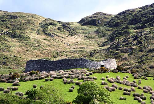
All of these ring forts are roughly the same age and have similar basic features. The circular dry-stone walls were built sometime between 500 BC and AD 300 without the aid of mortar or cement. About 80 feet across, with walls 12 feet thick at the base and up to 25 feet high, these brutish structures would have taken 100 men six months to complete. Expert opinion is divided on the reason they were built, but most believe that the people who built them would have retreated here at times of clan conflict. Civilization was morphing from nomadic hunter-gatherers to settled farmers, so herders used these forts to gather their valuable cattle inside and protect them from ancient rustlers. Other experts see the round design as a kind of amphitheater, where local clan chieftains would have gathered for important meetings or rituals. However, the ditch surrounding the outer walls of Staigue Fort suggests a defensive, rather than ceremonial, function. Without written records, we can only imagine the part these magnificent piles of finely stacked stones played in ancient dramas.
The thrill of visiting a ring fort is carefully scrambling up the uneven, stacked-stone steps integrated into the walls. Get up close, admire the dry-stone construction, and imagine how precisely every big, flat slab and perfectly sized pebble had to be laid for these forts to remain standing two millennia later.
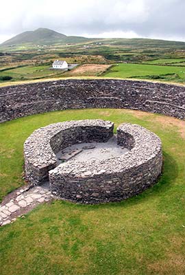
Because this region had copper mines, southwest Ireland has a wealth of prehistoric sights. The Bronze Age wouldn’t have been the Bronze Age without copper, which was melted with tin to make bronze for better weapons and tools (2000 to 500 BC). The many ring forts and stone circles reflect the affluence that the abundance of copper brought to the region.
FROM KENMARE TO WATERVILLE
Driving on N-70 through the outer sprawl of Kenmare, keep an eye on your left for peekaboo views over the inlet called Kenmare Bay. Eventually those views open up, and you’ll drive along a dramatic rocky coastline—a taste of what’s to come.
About 7 miles (12 km) out of Kenmare, at Blackwater Bridge, the road turns sharply left to go over a single-lane bridge. Soon after, the road pulls away from the sea and coasts through lush terrain.
About 3 miles (5 km) after the bridge, watch on the right for small Glacier Lake, with a long, smooth limestone “banister” carved by a glacier 10,000 years ago. Farther along, on the left, the recommended Parknasilla Resort—a posh 19th-century hotel—is a great stop for tea and scones.
• Soon—about 30 minutes after leaving Kenmare—the road approaches the village of...
Sneem
Although it’s inundated by tour buses daily from 14:00 to 16:00, the village of Sneem (pop. 300) is peaceful and laid-back the rest of the day. Sneem has several places to eat, drink, and (of course) shop. You can keep driving through, or stop for a quick look.
This humble town has two grassy, roughly triangular squares, separated by a bridge. Locals joke, “Since we’re in County Kerry, the square on the east side is called South Square and the one on the west is called North Square.”
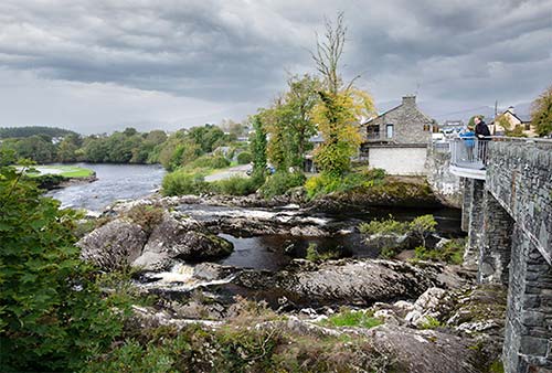
Approaching on the Ring, you’ll come first to South Square. Look for a statue of Steve “Crusher” Casey, the local boy who reigned as world-champion heavyweight wrestler (1938-1947). Continuing on, a sweet little peat-toned rapid gurgles over big rocks under the one-lane bridge connecting the two Sneem squares. If you’d like to get out for a more leisurely look, there’s also a pedestrian crossing on one side of this narrow bridge.
North Square features a memorial to former French president Charles de Gaulle’s visit (Irish on his mother’s side, de Gaulle came here for two weeks of R&R after his final retirement from office in 1969). Locals call it “da gallstone.” Also in this parklike square, the giant silvery feather was a gift from Israel to honor Irish president Cearbhall Ó Dálaigh (1974-1976), who lived in Sneem late in life. Facing North Square (at the end near the bridge), the bright-orange building with a picture of a bat has free WCs and a humble TI desk.
• Leaving Sneem, the scenery soon opens up with rocky coastline on your left and soaring hills with tidy farms on your right. About 9 miles (14 km) after Sneem, you’ll go through the tiny community of Castlecove; just after, watch carefully on your right for the turnoff to...
▲Staigue Fort
This impressive ring fort is worth a detour—though keep in mind that you could also visit the similar ring forts of Cahergal and Leacanabuaile toward the end of this drive.
The fort is 2.5 miles (4 km) off the main N-70 road up a very narrow (sometimes car-width) rural access lane, with foliage brushing your side-view mirrors. Honk on blind corners to warn oncoming traffic as you drive up. Park near the coffee-and-pastries cart, cross the little concrete bridge, and drop €1 in the little gray donation box beside the gate. Climb up the hill to the fort; the entrance is burrowed around the right side. From this vantage point, enjoy the remote and striking setting, with distant views to the Atlantic glimmering at the base of the valley. For more details on the significance of this sight, see “The Ring Forts of Kerry” sidebar.
• Head back to the main road and continue driving the Ring. Very soon after the Staigue Fort turnoff, look left across the bay to the Beara Peninsula, beyond a ruined hospital with IRA ties. It was funded in about 1910 by a local Englishwoman sympathetic to the Irish Republican cause. No one wants to touch these ruins today, for fear of “kicking up a beehive.”
Just 2 miles (3.5 km) after the Staigue Fort turnoff, watch on the left for the scenic pullout just before the road down to...
Carroll’s Cove
Pull over here to enjoy the views in both directions. If the weather’s fine and you brought a swimsuit, head on down to the beach and take a dip. Carroll’s Cove has a fine beach with some of the warmest water in Ireland, grand views of Kenmare Bay, a local trailer park and campground, plus “Ireland’s only beach bar.”
• Carry on along the main road. Just a couple of miles later, watch on the left for the turnoff to...
Derrynane House
This is the ancestral home of Daniel O’Connell, Ireland’s most influential 19th-century politician, whose tireless nonviolent agitation gained equality for Catholics 185 years ago. While casual visitors may find this sight dull, it’s worth ▲▲ for Irish patriots and history buffs. The coastal lands of the O’Connell estate that surround Derrynane (rhymes with Maryann) House are now a national historic park and include a beach just a five-minute walk away. A visit here is a window into the life of a man who not only liberated Ireland from the last oppressive anti-Catholic penal laws but also first developed the idea of a grassroots movement—organizing on a massive scale to achieve political ends without bloodshed (see the sidebar on Daniel O’Connell).
Born in Cahersiveen and elected from Ennis as the first Catholic member of the British Parliament, O’Connell was the hero of Catholic emancipation in Ireland. Educated in France at a time when punitive anti-Catholic laws limited schooling for Irish Catholics at home, he witnessed the carnage of the French Revolution. Upon his return to Ireland, he saw more bloodshed during the futile Rebellion of 1798.
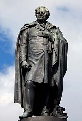
Abhorring all this violence, O’Connell dedicated himself to peacefully gaining equal rights for Catholics in an Ireland dominated by a wealthy Protestant minority. He formed the Catholic Association with a one-penny-per-month membership fee and quickly gained a huge following (especially among the poor) with his persuasive speaking skills. Although Catholics weren’t allowed to hold office, he ran for election to Parliament anyway and won a seat in 1828. His unwillingness to take the anti-Catholic Oath of Supremacy initially kept him out of Westminster, but the moral force of his victory caused the government to concede Catholic emancipation the following year.
Known as “the Liberator,” O’Connell began working toward his next goal—repealing the Act of Union with Britain. When his massive “monster meeting” rallies attracted thousands, his popularity spooked the British authorities, who threw him in jail on trumped-up charges of seditious conspiracy in 1844. When the Great Potato Famine hit in 1845, some Irish protesters advocated for more violent action against the British, which O’Connell had long opposed. He died two years later in Genoa on his way to Rome, but his ideals lived on: His Catholic Association was the model of grassroots organization for the Irish, both in their homeland and in America.
Cost and Hours: €5; daily 10:00-17:30, Oct until 17:00, Nov Sat-Sun only 10:00-16:00, closed Dec-mid-March; last entry one hour before closing, +353 66 947 5113, www.derrynanehouse.ie.
Eating: The museum has a good $ café with a nice-in-sunshine terrace.
Visiting the House: Ask about the next scheduled 20-minute film, which fleshes out O’Connell’s turbulent life and makes the contents of the house more interesting.
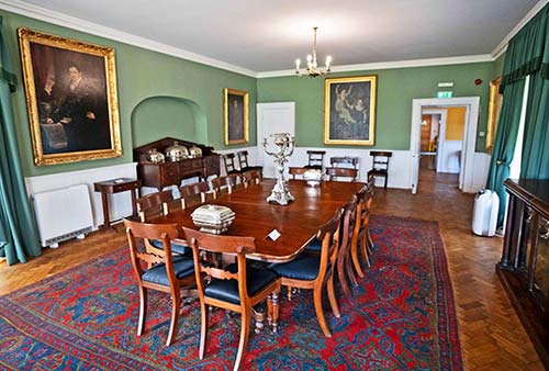
Then explore the house. Downstairs in the study, look for the glass case containing the pistols used in O’Connell’s famous duel. Beside them are his black gloves, one of which he always wore on his right hand when he went to Mass (out of remorse for the part it played in taking a man’s life). The dining room is lined with family portraits. Upstairs in the drawing room, you’ll find his ornately carved chair with tiny harp strings and wolfhound collars made of gold. And in the exhibition room is his deathbed, brought back from Genoa, and his christening bowl.
The coach house (out back) shows off the enormous grand chariot that carried O’Connell through throngs of joyous Dubliners after his release from prison in 1844. In a glass case opposite the chariot is a copy of O’Connell’s celebrated speech imploring the Irish not to riot when he was arrested. He added the small chapel wing to the house in gratitude to God for his prison release.
• Back on the main road past the Derrynane turnoff, you’ll gain altitude on the way to...
▲Coomakesta Pass
This increasingly scenic road carries you up over the headland, from one bay to the next. There are several strategically situated pullouts to choose from; most drivers (including tour buses) wait for the giant parking lot at the very top (700-foot altitude), offering windblown views in both directions. This is worth a quick stop.
From here, you’ll coast downhill again toward an entirely different set of grand views—rolling farms and short cliffs. On a clear day, watch for fine views of the distant Skellig Islands with their pointy summits.
• Soon you pull into the town of...
Waterville
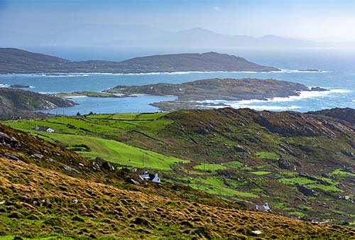
In this charming beach town, the road runs down along the water. In the heart of town, keep an eye on the left side of the road for a sculpture of Charlie Chaplin standing on the waterfront. Just beyond is a second statue, honoring Mick O’Dwyer, a Gaelic football star and local hero. Waterville is also home to the Butler Arms Hotel—a fine stop for tea and scones in its Charlie Chaplin room (with lots of photos of the silent-film icon and his young wife frolicking as they lived well in Ireland).
• After leaving Waterville, the road curves left at a church and gas station. About 2.5 miles (3.5 km) past the Chaplin statue, just after you cross a small bridge that’s locally famous for salmon fly-fishing, watch carefully for the next left, which is R-567 (marked for Ballinskelligs Bay). Taking this turn, you’ll leave the big-bus route and embark on the...
SKELLIG RING
While the main N-70 road bypasses this ruffled ridge of land entirely—cutting across the headland to Cahersiveen—that’s a shame, because this area is home to some of the most ruggedly memorable Ring of Kerry scenery. The Skellig Ring is named for those pointy, castaway islands—which we’ve been seeing since shortly after we left Kenmare—where medieval monks holed up. This stretch of the drive is on rural roads where navigation can be a little tricky. When in doubt, follow signs for Valentia Island and Portmagee.
• After a few miles on R-567, you’ll reach a T-intersection; bear left onto R-566 to continue into the village of Ballinskelligs (marked on signs with its Gaelic name, Baile an Sceilg). There are a few intersections through the village; stay on R-566 and keep tracking signs for Valentia Island and Portmagee.
Leaving Ballinskelligs, the road narrows and twists up over the headland. After driving a few more miles and dropping down on the other side, you’re on your way into...
▲St. Finian’s Bay
Near where you arrive at sea level, watch on the right for the slick, modern building housing Skelligs Chocolate Factory. Here you can watch chocolatiers in action, try samples, buy bars or truffles, and get hot chocolate at the café (there’s also a playground for kids, +353 66 947 9119, https://skelligschocolate.com).
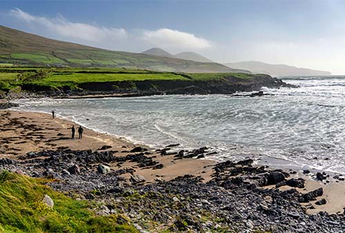
From the chocolate factory, it’s a very quick drive to a pleasant picnic-friendly beach that’s recently been discovered by surfers. This is an ideal spot to pull over and take an easy walk down to the churning surf. Just above the beach is the seasonal $ An Bothán coffee truck, with pastries and light meals; just up the hill behind is the sit-down $$ Driftwood Surf Café.
• Continuing on, you’ll twist up again steeply as the road narrows, offering increasingly dramatic views back down over the bay. Cresting the hill, turn left (toward Portmagee) toward yet another stunning Kerry panorama.
As the road descends and flattens out, about 3.5 miles (6 km) after leaving St. Finian’s Bay, watch on the left for the big gravel parking lot of the...
▲Kerry Cliffs
Signs here advertise “Best View in County Kerry.” On the one hand, this feels like a tacky private enterprise; on the other hand, the cliff views are among the best of the Ring of Kerry—worth the time, money, and short hike in good weather.
Park and pay the €5 fee at the hut (generally about 9:00-18:00). Then walk 10 minutes up the gravel road to a dramatic cliff with expansive coastal views. The beehive huts on the way up are replicas but true to the originals.
• Just after the Kerry Cliffs, you enter the outskirts of...
Portmagee
Just a short row of snoozy buildings lining the bay, Portmagee is the best harbor for boat excursions out to the Skellig Islands (see the “Skellig Michael” section at the end of this chapter). It’s a quiet village with a handful of B&Bs, two pubs, and a market. On the rough harborfront, a slate memorial to sailors from here who were lost at sea reads, “In the nets of God may we be gathered.”
A 100-yard-long bridge connects Portmagee to gentle Valentia Island and the Skellig Experience Centre (described later). A public parking lot is at the Portmagee end of the bridge, with WCs. The first permanent transatlantic cable (for telegraph communication) was laid from Valentia Island in 1866.
Sleeping in Portmagee: $$ Moorings Guesthouse feels like a small hotel, with 17 rooms, a pub and a good restaurant downstairs, and the most convenient location in town, 50 yards from the end of the pier (family rooms, +353 66 947 7108, www.moorings.ie, enquiries@moorings.ie, Gerard and Patricia Kennedy).
Eating in Portmagee: These options all line the waterfront (between the pier and the bridge to Valentia Island). $$$ The Moorings is a nice restaurant with great seafood caught literally just outside its front door (daily, reservations smart, see contact info above). Their $$ Bridge Bar, next door, does traditional pub grub, with occasional trad music sessions (open daily, +353 66 947 7108). The $$ Fisherman’s Bar is less flashy, with more locals and cheaper prices, and a nice terrace out near the harbor (daily, +353 66 947 7103). For picnic supplies, O’Connell’s is the only grocery (daily, has packed lunches for Skellig Michael excursions).
• When you’re done visiting Portmagee, drive across the bridge to...
Valentia Island
The island’s name hints at medieval trading connections with nearby Spain, which lies due south.
• The first sight you’ll reach on the island is immediately across the bridge on the left; it looks like a long, low, stacked-stone building burrowed into the grassy hillside.
▲Skellig Experience Centre
Whether or not you’re actually sailing to Skellig Michael (described at the end of this chapter), this little center explains it well. A 13-minute film sets the stage, and modest exhibits explain the story of the monks, the construction of the settlement, the logistics of visiting, the lighthouse, and the natural environment—including the bird life. The Skellig Experience Centre also runs boat trips that cruise around and ones that land on Skellig Michael (for details, see here).
Cost and Hours: €5; daily 10:00-17:30, July-Aug until 18:30, shorter hours off-season; +353 66 947 6306, www.skelligexperience.com.
• From here, if you’re in a rush and want to skip the rest of Valentia Island and its charming car ferry, simply head back into Portmagee, turn left on R-565, and follow it to rejoin the main N-70 Ring of Kerry road into Cahersiveen (if doing this, skip ahead to “The Rest of the Ring of Kerry,” later). But the route I’ve outlined next is more interesting and more scenic, and the driving time is similar though less predictable (it depends on how long you have to wait to board the ferry).
To stick with me, continue past the Skellig Experience Centre. From here, follow R-565 about 4.5 miles (7 km) across the middle of Valentia Island to the village of Knightstown, arriving at a triangular square, with a parking lot in front of a big church. Just up the road to your left (along the right side of the church) is a modest museum.
Valentia Heritage Museum
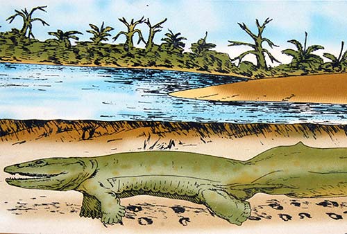
The humble Knightstown schoolhouse, built in 1861, houses an equally humble but interesting museum about the quirky historical highlights of Valentia Island. You’ll see a 19th-century schoolroom and learn about tetrapods (those first fish to climb onto land—which locals claim happened here). You’ll also follow the long story of the expensive, frustrating, and heroic battle to lay telegraph cable across the Atlantic, which—after some false starts—finally succeeded in 1866, when the largest ship in the world connected the tiny island of Valentia with Newfoundland. This project was the initiative of the Atlantic Telegraph Company, which later became Western Union. These stories and more are told with intimate black-and-white photos and typewritten pages.
Evolution, literacy, communication—Ireland has played a starring role in all three.
Many Irish paleontologists believe that the fossilized tetrapod tracks preserved on Valentia Island are the oldest in Europe. It was here that some of the first fish slithered out of the water on four stubby legs 385 million years ago, onto what would become the Isle of Saints and Scholars. Over time, those tetrapods evolved into the ancestors of today’s amphibians, reptiles, birds, mammals...and humans, with the desire to record their thoughts and history, and communicate with others across the miles.
Irish scribes—living in remote outposts like the Skellig Islands, just off this coast—kept literate life alive in Europe through the darkest depths of the Middle Ages. In fact, in about the year 800, Charlemagne imported monks from this part of Ireland to be his scribes.
Just over a thousand years later, in the mid-19th century, Paul Julius Reuter—who provided a financial news service in Europe—knew his pigeons couldn’t fly across the Atlantic. So he relied on ships coming from America to drop a news capsule overboard as they rounded this southwest corner of Ireland. His boys would wait in their little boats with nets to “get the scoop.” They say Europe learned of Lincoln’s assassination (1865) from a capsule tossed out of a boat here.
The first permanent telegraph cables were laid across the Atlantic from here to Newfoundland, giving the two hemispheres instantaneous electronic communication. Queen Victoria was the first to send a message—greeting American president James Buchanan in 1858. The cable broke more than once, but it was finally permanently secured in 1866. Radio technology pioneer Guglielmo Marconi, who was half-Irish, set up an early wireless telegraph station in this corner of Ireland before he achieved the first wireless transatlantic communication in 1901 from England to Newfoundland.
Today, driving under the 21st-century mobile-phone and satellite tower that crowns a hilltop above Valentia Island, while gazing out at the Skellig Islands, a traveler has to marvel at humanity’s progress—and the part this remote corner of Ireland played in it.
Cost and Hours: €3.50, daily 10:00-17:00, closed Oct-March, +353 66 947 6411, https://valentiaisland.ie.
Nearby: Before leaving Valentia Island, dinosaur hunters may want to detour to the modest but ancient tetrapod tracks, frozen in stone, on the north side of the island. The actual “first footprints” are a 15-minute drive from the museum, on a rugged bit of rocky shoreline, a 10-minute hike below a parking lot (free, always viewable, ask locally for details).
• Next up: a fun, quick, and scenic ferry crossing. Continue the rest of the way into Knightstown and down to its little waterfront area. Turn right at the harbor and get in line for the sweet little...
Valentia Island Car Ferry
This practical, if pricey, little vessel continuously loads up with cars to make the blink-or-you’ll-miss-it, four-minute crossing from Knightstown to Reenard Point, back on the mainland (€11/car, runs continuously 8:00-21:00). The harbor areas for these two tiny communities are so close, they practically touch...you’ll feel like you’re “at sea” for all of about 200 yards.
• Oops! Better get back in your car, because we’re almost docked...and that crew doesn’t dillydally.
REST OF THE RING OF KERRY
We’ve officially left the Skellig Ring and are about to rejoin N-70, the main Ring of Kerry route. We’ve seen most of the best of the Ring of Kerry. There’s just one more worthwhile stop coming up soon—a pair of ring forts—and a good bit more driving.
• Drive off the ferry and onto N-70, turning left for the town of Cahersiveen. After just a couple of miles, you’re in long, skinny Cahersiveen—which feels like a return to civilization after a couple of hours of tiny villages and lonely bays.
In town is the turnoff for the Cahergal and Leacanabuaile ring forts. If you didn’t stop at Staigue Fort near the start of our drive, and if weather and time permit, this is a must. If you already saw Staigue, these may be skippable. Read the description below and decide.
To get to the ring forts, turn left at the tourist office just beyond the Cahersiveen town church, cross the narrow bridge, turn left again, and follow signs—you’ll see the huge stone structures in the distance (2.5 miles (4 km) off the main road).
▲Cahergal and Leacanabuaile Ring Forts
Crowning bluffs in farm country, these two windy and desolate forts are each different and worth a look. They are about a five-minute walk (in different directions) from the tiny parking lot (free, always open, no museum). If you’re a “one ring fort is plenty” kind of person, just head to the right for Cahergal. Scampering up the dry stone steps and looking out at the very Irish countryside is a wonderful capper for your busy Ring of Kerry day. (For details on the importance of these structures, see the “Ring Forts of Kerry” sidebar, earlier.)
• Return to N-70 at Cahersiveen and follow signs for Glenbeigh and Killorglin. The main sightseeing stops are complete, so just sit back and enjoy the...
Rest of the Drive
You’ll pass through some pleasant countryside before crossing another rise and hitting the water again near little Kells Bay. From here, enjoy sweeping views of the Dingle Peninsula across the vast Dingle Bay to your left. Eagle eyes can spot stumpy Eask Tower and Inch Beach.
You’ll pass along a dramatic stretch of cliffs, then cut back into foliage the rest of the way to Glenbeigh and Killorglin. At Killorglin, you’ve seen the best of the Ring. From here, go either to Dingle (left) or to Kenmare/Killarney/Kinsale (right). To either Dingle or Kenmare, it’s about an hour’s drive from this point.
Congratulations! You’ve completed the Ring of Kerry.
Skellig Michael
A trip to this jagged, isolated pyramid—the Holy Grail of Irish monastic island settlements—rates as a truly memorable ▲▲▲ experience. After visiting Skellig Michael a hundred years ago, Nobel Prize-winning Irish playwright George Bernard Shaw called it “the most fantastic and impossible rock in the world.”
Rising seven miles offshore, the Skelligs (Irish for “splinter”) are two gigantic slate-and-sandstone rocks crouched aggressively on the ocean horizon. The larger of the two, Skellig Michael, is more than 700 feet tall and a mile around, with a tiny cluster of abandoned beehive huts clinging near its summit like stubborn barnacles. The smaller island, Little Skellig, is home to a huge colony of gannet birds (like large, graceful seagulls with six-foot wingspans), protected by law from visitors setting foot onshore.
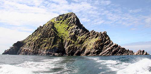
Skellig Michael (dedicated to the archangel) was first inhabited by sixth-century Christian monks. Inspired by earlier hermit-monks in the Egyptian desert, they sought the purity of isolation to get closer to God. Neither Viking raids nor winter storms could dislodge them, as they patiently built a half-dozen small, stone, igloo-like dwellings and a couple of tiny oratories. Their remote cliff-terrace perch is still connected to the sea 600 feet below by an amazing series of rock stairs. Viking Olav Trygvasson, who later became king of Norway and introduced Christianity to his country, was baptized here in 993.
Chiseling the most rudimentary life from solid rock, the monks lived a harsh, lonely, disciplined existence here, their colony surviving for more than 500 years. They collected rainwater in cisterns and lived off fish and birds. To supplement their meager existence, they traded bird eggs and feathers with passing boats for cereals, candles, and animal hides (used for clothing and for copying scripture). They finally moved their holy community ashore to Ballinskelligs in the early 1100s. But Christian pilgrims continued to visit Skellig Michael for centuries as penance...edging out onto a ledge to kiss a stone cross that has since toppled into the ocean.
In 2014, the ruggedly exotic Skellig Michael was used as a filming location for Star Wars: The Force Awakens. (This was where an aging Luke Skywalker was hiding out, far from the prying eyes of the galaxy.) To keep the filming top-secret, the Irish Navy was called in to enforce a two-mile exclusionary zone around the island. But environmental groups voiced concerns about the impact on the island’s fragile ecosystem, especially native seabirds. Disney scrapped plans for filming the next installment, The Last Jedi, on the island. Instead it built its own version of the location at Sybil Head on the Dingle Peninsula. Expect a constant stream of Star Wars tourists at both filming locations. Go mbeidh an Fórsa leat! (May the Force be with you!)
GETTING THERE
Boat trips sail from Portmagee to Skellig Michael daily from about mid-May through September, but the schedule is heavily dependent on weather conditions. If the seas are too choppy, the boats cannot safely drop people at the concrete island pier (it’s a bit like jumping off a trampoline onto an ice rink). Experienced boat captains say they are able to bring visitors ashore roughly five days out of seven in an average summer week.
In addition to weather constraints, the number of daily visitors to the island is limited due to its fragile ecosystem as a puffin breeding ground. Just 15 boats carrying 12 passengers each are licensed to land on the island once a day. Additional boats circle the island without landing.
Booking a Trip: Tickets sell out months in advance. As soon as you know your travel dates, you can ask the host at your accommodations for help; many know of a limited number of sailing slots through their local connections.
The Skellig Experience Centre arranges 2.5-hour boat trips, circling both Skellig Michael and Little Skellig—ideal for those who want a close look without the stair climb and vertigo that go with a visit to the island (€50, daily at 12:30 and 15:00 in season). Landing boat trips give you about 2.5 hours on shore at Skellig Michael (€120, 1/day in season, departs sometime between 9:30 and 10:30, 5 hours total, get details and book at www.skelligexperience.com). All departures are weather permitting from the Valentia Island pier 50 yards below the Skellig Experience Centre.
You can also try contacting boat captains individually: Paul Devane (+353 87 617 8114, www.skelligmichaelcruises.com), Patrick Murphy (+353 87 234 2168), or Brendan Casey (+353 66 947 2437, mobile +353 87 450 1211).
Boats that land on the island cost €120-150 and generally depart Portmagee between 8:00 and 10:30 (depending on tides), sail for an hour, then leave you on the island for a few hours before getting you back into Portmagee between 14:30 and 16:30. You can also ask about boat trips that circle the island without landing.
Planning Tips: Your best bet is to reserve a room near Portmagee or St. Finian’s Bay. It’s possible to sleep in Kenmare and get up early to drive two hours straight to Portmagee—but you’ll be frustrated by not having time to enjoy the Ring’s attractions along the way. Contact the boat operator on the morning of departure to find out whether the weather is favorable for sailing.
Bring your camera, lunch, water, sunscreen, rain gear, hiking shoes, and sense of wonder.
VISITING SKELLIG MICHAEL
Since you’ll have only about 2.5 hours to explore the island, begin by climbing the seemingly unending series of stone stairs to the monastic ruins (600 vertical feet of uneven steps with no handrails). Save most of your picture-taking for the way down. Those who linger too long below risk missing the enlightening 20-minute free talk among the beehive huts, given by guides who camp on the island from May through September. Afterward, poke your head into some of the huts and try to imagine the dark, damp, and devoted life of a monk here more than 1,000 years ago. After rambling through the ruins, you can give in to the puffin-spotting photo frenzy as you wander back down the stairs.
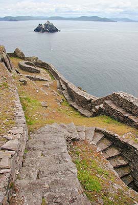
The two lighthouses on the far side of the island are now automated, and access to them has been blocked off. There are no WCs or modern shelters of any kind on Skellig Michael.
If you visit between May and early August, you’ll be surrounded by fearless rainbow-beaked puffins, which nest here in underground burrows. Their bizarre, swallowed cooing sounds like a distant chainsaw. These portly little birds live off fish, and divers have reported seeing them 20 feet underwater in pursuit of their prey.
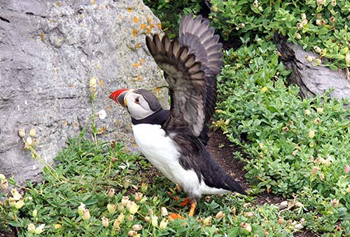
Your return boat journey usually includes a pass near Little Skellig, which looms like an iceberg with a white coat of guano—courtesy of the 20,000 gannets that circle overhead like feathered confetti. These large birds suddenly morph into sleek darts when pursuing a fish, piercing the water from more than 100 feet above. You’re also likely to get a glimpse of gray seals lazing on rocks near the water’s edge.