COUNTY CLARE & THE BURREN
Cliffs of Moher • Doolin • Lisdoonvarna • Ennis • Irish Workhouse Centre
Map: County Clare & the Burren
Those connecting Dingle with Galway can entertain themselves along the way by joyriding along the dramatic coastal cliffs, evocative landscape, and tidy villages of County Clare.
Most of this area’s top sights are rural. Overlooking the Atlantic, the dramatic Cliffs of Moher—one of Ireland’s best-known scenic spots—offer tenderfeet a thrilling hike. And the Burren is a unique, windblown limestone moonscape that hides an abundance of flora, fauna, caves, and history, with stops ranging from prehistoric forts and tombs to a modern perfumery.
The towns and villages of County Clare are humble, but pleasant enough for home-basing. Cheerful Doolin, within sight of the Cliffs of Moher, is famous for its traditional music and offers close access to the natural sights—including an easy boat crossing to the isle of Inisheer (covered in the Aran Islands chapter). Just up the road, Lisdoonvarna is known for its matchmaking festival; the rest of the year, it’s just a sleepy small town with some fine B&Bs. And workaday Ennis, the county’s leading city, is less touristy, with a fine traditional music scene, and a market bustle.
To round out your experience in this part of Ireland, the sobering Irish Workhouse Centre in Portumna (just over the border in County Galway) offers an opportunity to contemplate the country’s harsh Victorian Era “solution” to the Great Potato Famine.
PLANNING YOUR TIME
By Car: A car is the best way to experience County Clare and the Burren. For drivers, this area can be an enjoyable daylong drive-through on your way between Dingle and Galway, or a destination in itself. One night is plenty to see this area’s attractions at a more leisurely pace.
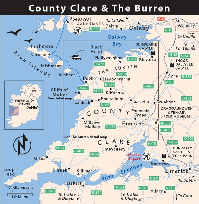
On a long single-day drive from Dingle to Galway (figure about 5 hours of driving total, plus stops), consider this plan: Rather than taking the (boring) main N-21 road via Limerick, drive north from Tralee on N-69 via Listowel to catch the Tarbert-Killimer car ferry (avoiding Limerick traffic). Even though the ferry is slower and more expensive, it’s more direct to the Burren (ferry details are at the end of the previous chapter; to reduce waiting time at the dock, check the schedule in advance for the hourly crossing). From Killimer, drive north on N-67 via Kilkee and Milltown Malbay. The little surfer-and-golfer village of Lahinch makes a good lunch stop. Then drive the coastal route to the Cliffs of Moher for an hour-long break. (You could wait to eat at the cafeteria at the cliffs, but big bus tour groups can smother it at midday in summer.) The scenic drive from the cliffs through Doolin and the Burren, with a couple of brief stops, takes about two hours. If it’s offered, consider the medieval banquet at Dunguaire Castle, near Kinvarra, for dinner (30 minutes south of Galway, book ahead), then end in Galway.
With a single overnight, choose between sleeping in little Doolin (my preference for its charm, music scene, and proximity to the Cliffs of Moher, the Burren, and Inisheer), bigger Lisdoonvarna (still close to Doolin and the natural sights), or the even bigger Ennis (which feels like a real town, and is handy to Shannon Airport). A good plan would be to visit the Cliffs of Moher on your way to Doolin, ending your day with traditional music at a local pub. The next morning, take the early boat to Inisheer, return mid-afternoon, then do the Burren Drive on your way north to Galway.
By Train or Bus: Without a car, I’d consider skipping this region. Limerick (via Ennis) and Galway are connected by rail, but linking the smaller sights within County Clare and the Burren by bus is difficult: Book a tour instead (see “Tours in the Burren,” later in this chapter).
Tip: Skip the crowded Bunratty Castle and Folk Park between Limerick and Shannon.
County Clare’s Coast
The coastline of County Clare has one of Ireland’s grandest natural sights: the vast and iconic Cliffs of Moher. Nearby are fine villages suitable for an overnight—Doolin or Lisdoonvarna. This area is an ideal jumping-off point for a drive around the Burren (covered in the next section). Looming just offshore are the Aran Islands; the closest one, Inisheer, is very easily reached on a 15-minute boat ride from Doolin (for details, see the Aran Islands chapter).
Cliffs of Moher
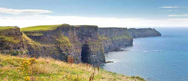
A visit to the Cliffs of Moher (pronounced “MO-hur”)—a ▲▲ sight—is one of Ireland’s great natural thrills. For five miles, the dramatic cliffs soar as high as 650 feet above the Atlantic.
GETTING THERE
By Car
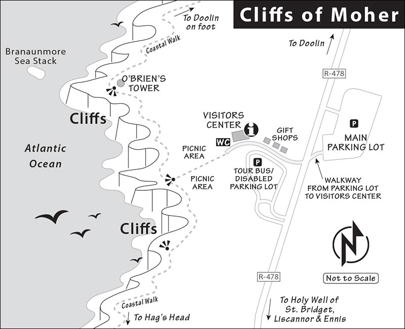
The Cliffs of Moher are located on R-478, south of Doolin. Park across the road from the visitors center: Pay the attendant as you drive in, park, then walk across the road. (The lot directly next to the visitors center is for tour buses and visitors with disabilities.)
Without a Car
From Galway: Galway Tour Company offers an all-day Aran Islands and the Cliffs cruise that includes visits to the Aran Island of Inisheer and the Cliffs of Moher (€70, includes cliffs admission, daily mid-March-Oct departing at 9:00 and returning at 19:30; see listing on here for contact details). They also offer a tour that includes the Burren (see “Tours in the Burren,” later in this chapter).
You can also get here by public bus from Galway (8/day in summer, some with change in Ennis, 2 hours, www.buseireann.ie).
From Doolin: The Cliffs of Moher are reachable by coastal hike, or you can take a cruise from Doolin to see (but not visit) the cliffs. For details, see “Activities in Doolin,” later.
ORIENTATION TO THE CLIFFS OF MOHER
Cost: €12, may be cheaper if you book ahead online; ticket includes parking, admission to the visitors center and exhibit, and an informative downloadable audioguide.
Hours: Daily 8:00-19:00, gradually later closing times toward midsummer (as late as 21:00 May-Aug), Nov-Feb 9:00-17:00. It’s worth coming early or late to avoid the midday hordes.
Information: +353 65 708 6141, www.cliffsofmoher.ie.
Services: You’ll find an information desk and WCs in the visitors center—the Tolkienesque labyrinth tucked under the grassy hillside—flanked by six hobbit garages housing gift shops (across the street from the parking lot).
Eating: $$ Cliffs View Café, upstairs in the visitors center, serves coffee and substantial cafeteria-style hot meals until 16:30, and snacks until 18:00. $ The Puffin’s Nest is a small sandwich café downstairs, where you enter. At midday, both can be very crowded with big bus groups.
VISITING THE CLIFFS OF MOHER
The visitors center (billed as “The Cliffs of Moher Experience”) is designed smartly to orient you to the cliffs, spiraling up and finally out onto the cliffs themselves in this order: entry (info desk, shop, basic café), nature exhibit and short film, main restaurant and WC, and outside to the cliffs. You can do the visitors center before or after your cliff walk, depending on the weather.
Visitors Center: Head up the ramp to the main exhibit; while pretty thin, it includes natural and geological history, native bird and marine life, and virtual interactive exhibits aimed at children. You may even learn why the cliffs are always windy. A small theater continuously shows The Ledge Experience, a five-minute film following a gannet as he flies along the cliffs and then dives underwater, encountering puffins, seals, and even a humpback whale along the way.
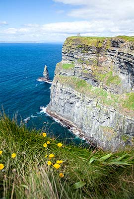
The Cliffs: After leaving the visitors center, walk 200 yards to the cliff edge. The trail to the right (north, uphill toward the castle-like tower) is the most rewarding. If time is short, head up here first; with more time, you can circle back around to the left side later.
About 300 million years ago, this was the delta of a gigantic river, depositing vast volumes of silt that gradually built up in the layers of shale and sandstone that you can see in cross-section as you survey the cliffs. The erosion of these exposed layers has created lots of little nooks and crannies in the cliff walls, ideal habitat where about 60,000 sea birds nest through the summer months.
You may see old photos of people clambering right out to the very edge of the cliffs, even poking their head over the ledge. Back then, the Irish didn’t believe in safety fences...“just natural selection.” But numerous fatal accidents (and suicides) prompted construction of a chest-high protective wall of the local Liscannor slate (notice the squiggles made by worms, eels, and snails long ago when the slate was still mud on the seafloor) that keeps visitors safely back from the edge. Uniformed “rangers”—ostensibly there to answer questions—keep wayward visitors from getting too close (wind gusts can be sudden, strong, and deadly).
As you gaze down at the waves crashing far, far below you, consider this: Surfing in wet suits is popular in Ireland. Most sane Irish surfers stick to the predictable waves at Lahinch (5 miles south of here). But the monster waves that rear up beneath the Cliffs of Moher on stormy days are coveted by extreme surfers, who work in tandem with tow/rescue helpers skimming the waves on Jet Skis. (You can check it out on YouTube.)
It’s about a five-minute uphill walk to the best views—at the base of O’Brien’s Tower, built in 1835. (You can climb the 43 spiral stairs to the top, but I’d skip it—30 feet up doesn’t improve the views much, and the gaps between the crenellations are comically narrow.) In the distance, on windy days, you can see the Aran Islands wearing their white necklace of surf. Make sure to walk a couple of minutes beyond the tower, and peer down into the next cove, where thundering waves crash against the base of a dramatic sheer cliff. From here, the Cliffs of Moher Coastal Walk goes all the way to Doolin, about five miles away. You can follow this as far as you like before turning back.
Or you can follow the walk in the opposite direction: From the main viewpoint, look left (south) and spot the tiny tower in the far distance, marking Hag’s Head. It’s farther than it looks because of the gaping alcoves hidden behind each cliff headland, but fit hikers can spend 2.5 hours (5 miles round-trip) following the up-and-down trail along the lip of the cliffs the whole way. Initially, you’ll be slowed down by idle crowds on the too-narrow trail (flagstones on one side, barbed and electric fencing on the other side). But after 500 yards, you’ll leave them behind and can pick up the pace.
Eventually, you’ll have nothing between you and the abyss. Be extremely careful on the uneven trail (next to unsupported overhangs) and mindful of the sudden wind gusts. Although the cliffs become less spectacular the farther you go, this hike is a great excuse to stretch your legs. Eventually the path links to the Burren Way trail.
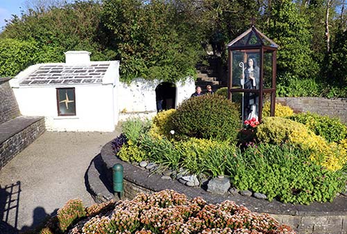
Nearby: Before leaving the area, drivers can take 10 minutes to check out the Holy Well of St. Bridget, located beside the tall column about a half-mile (1 km) south of the cliffs on the main road to Liscannor. In the short hall leading into the hillside spring, you’ll find a treasure of ex-votos (religious offerings) left behind by devoted visitors seeking cures and blessings. A trickle of water springs from the hillside at the far end. To the right of the simple hall entrance is a stairway heading up into a peaceful graveyard. Be sure to check out the wishing tree (sometimes called a fairy bush or rag tree) halfway up the left side of the stairway. It’s usually draped in ribbons tied to branches. These were offerings to saints as part of a healing ritual. The simple gray column outside was a folly erected over 150 years ago by a local landlord with money and ego to burn.
Doolin
This village of about 500 people is a handy base for seeing the Cliffs of Moher and exploring the nearby Burren—and, as a bonus, it comes with a lively trad music scene. Doolin has long been a mecca for Irish musicians, who came together here to play before a few lucky aficionados. Slowly, word got out, and Doolin has found itself firmly on the traditional-music tourist map. As the bodhrán beat goes on—as it always has—a few high-end hotels and fine-dining restaurants are popping up between Doolin’s old, characteristic B&Bs.
Doolin is definitely discovered, and there are plenty of Irish towns with a music scene that’s every bit as rich (personally, I give a slight edge to Dingle’s). But it remains a mellow, musical place to settle in for a night or two of entertaining evenings and exploring County Clare. Doolin has great pubs, good restaurants, ample accommodations, and a Greek-island-without-the-sun ambience. And if you’re looking for an easy taste of the Aran Islands (covered in their own chapter), without devoting a full day to Inishmore, Doolin is the base for the quick and easy 15-minute crossing to compact, accessible Inisheer.
Orientation to Doolin
Doolin has a long string of homes, shops, eateries, and pubs stretching along a valley road from the tiny harbor up into the hills. It’s easiest to think of the village in chunks: First, there’s the harbor, tethered to town by a lonesome road that runs past distant views of the Cliffs of Moher and a bumpy pitch-and-putt golf course. Then you reach the Lower Village, huddled around its picturesque stone bridge, with some good accommodations and one of the top music pubs (Gus O’Connor’s). From here, the road heads through what I think of as “Midtown Doolin”—anchored by a strip mall with eateries, the big Hotel Doolin, and a humble, unofficial TI with brochures and WCs. Finally, clustered around another stone bridge is the Upper Village, with two more legendary music pubs (McDermott’s and McGann’s) and another smattering of accommodations and eateries.
The recommended Lodge Doolin offers laundry service, even for nonguests. Peter Mooney taxi is handy for folks without wheels wanting to link a night of fun in Doolin with a bed in Lisdoonvarna (+353 87 206 9019).
Activities in Doolin
▲▲▲Traditional Music
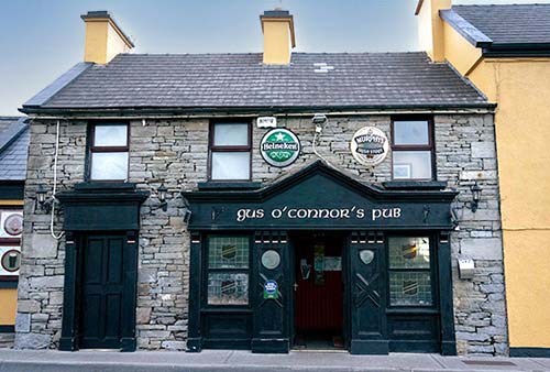
Doolin is famous for three pubs, all featuring Irish folk music: At the bridge in the Lower Village stands Gus O’Connor’s (https://gusoconnorsdoolin.com [URL inactive]). A mile farther up the road, the Upper Village—straddling a bridge—are McGann’s (https://mcgannsdoolin.com) and McDermott’s (https://mcdermottspub.com). All three are open early and serve food until a bit before the music begins, typically around 21:30. The music finishes at about midnight. Get there before 21:00 if you want a place to sit, or pop in later and plan on standing. The craic is great regardless.
At Doolin Music House, you can enjoy live trad music and folklore by accomplished flute-and-whistle player Christy Barry in his home. It’s a wonderfully cozy and intimate small-group experience (€30, advance booking required; Mon-Tue and Fri 19:00-20:30, +353 65 707 4584, mobile +353 86 824 1085, www.doolinmusichouse.com).
▲▲Boat Trips to Inisheer
Inishmore is the biggest Aran Island and gets most of the attention. But teensy, sleepy Inisheer, just a 15-minute boat trip offshore from Doolin, offers a quick and easy taste of Aran Islands scenery and culture. It’s a worthwhile half-day side trip from Doolin Harbor; if you’re spending time in this area, you’ll likely find this option simple and satisfying compared to the more complex options for reaching Inishmore. For details, see the Aran Islands chapter.
Hike or Cruise to the Cliffs of Moher
From Doolin, you can hike down the coast to the Cliffs of Moher. Local guide and farmer Pat Sweeny operates Doolin Cliff Walk, leading walking tours that depart daily at 10:00 from the Coffee Dock at the Doolin Inn (May-Sept, weather permitting, wear hiking footwear). The five-mile walk to the cliffs takes four hours and is not safe for kids under age 10 (€25, cash only, includes taxi fare back to Doolin, +353 65 707 4170, mobile +353 86 822 9913, www.doolincliffwalk.com, pat@doolincliffwalk.com, phone ahead to reserve and check weather/trail conditions).
To get a different perspective of the cliffs, you can take a boat cruise along their base with the Doolin Ferry Co (€28, 50 minutes, March-Oct 4/day, weather and tides permitting, check online for sailing schedule and to reserve, +353 65 707 5555, https://doolinferry.com). Try for an afternoon cruise, when the sun is coming from the west, illuminating the detail on the dramatic cliffs. The same company also operates a day-trip cruise from Doolin to Inisheer (the closest Aran Island), then along the base of the Cliffs of Moher and back to Doolin (for details, see here).
Pitch-and-Putt Course
Doolin Pitch-and-Putt is a beautiful, undulating golf course scenically located in the countryside along the road to the harbor, with views of the Cliffs of Moher (€10 plus €2 club rental, daily in good weather 10:00 until late, +353 86 837 4289, https://doolinpitchandputt.com).
Sleeping in Doolin
$$$ Sheedy’s Doolin is a new-feeling, handsome home set back from the main road about midvillage. This classy, high-end B&B has seven rooms, a midcentury-modern guest lounge, and prizewinning breakfasts (2-night minimum, Teergonean, +353 86 070 6263, https://sheedysdoolin.com, info@sheedysdoolin.com, Marian and Frank).
$$$ Doolin Inn was once a backpacker place but (emblematic of how Doolin has changed) it’s gone upscale. Expertly overseen by Anthony and Deirdre, it has a restaurant with live music at dinnertime most nights through the season. The 41 earth-toned rooms include several suites (+353 65 707 4421, 1 Fisher Street, Ballyvara, www.doolininn.ie, reservations@doolininn.ie).
$$ Daly’s House is a gem that’s worth booking early. Well run by kind Susan, it offers four rooms in a beautiful home tucked in the quiet backstreets of the Lower Village (just up the road behind Gus O’Connor’s). It has welcoming guest lounges and a fine garden, too (Doonmacfelim, +353 87 969 0583, https://dalyshouse.com, dalyshouse@gmail.com).
$$ Twin Peaks B&B, next door to Daly’s and run by Susan’s niece Sinéad and her husband Pascal, offers seven fine rooms and a warm welcome (+353 86 812 7049, www.twinpeaksdoolin.com, twinpeaksdoolin@gmail.com).
$$ The Lodge Doolin is a modern compound of four stone buildings with 21 bright, airy rooms, available either as a B&B or self-catering (laundry service, located halfway between Upper and Lower Villages, +353 65 707 4888, www.doolinlodge.com, info@doolinlodge.com).
$ Atlantic View House fills a giant home in the countryside, on the road between the village and the harbor (and better for drivers), with eight simple but big, comfortable, woody rooms—all upstairs (+353 65 707 4189, www.atlanticviewdoolin.ie, atlanticviewdoolin@gmail.com, Eileen).
Eating in Doolin
Rustic Fine Dining: $$$$ Oar Restaurant has earned an accolade in the Michelin Guide. In the Upper Village, its two- and three-course tasting menus make for a memorable dinner. Reservations are required (closed Mon-Tue, Roadford, +353 65 704 7990, https://oardoolin.ie/oar-restaurant).
Legendary Music Pubs: If you’re heading out for some music, arrive early and have some pub grub first. When choosing a table, ask where the musicians will perform (many pubs have multiple rooms). In the Lower Village, it’s $$ Gus O’Connor’s Pub, while the Upper Village has $$ McDermott’s and $$ McGann’s (all described earlier, under “Nightlife in Doolin”).
Simple Restaurant: $$$ Ivy Cottage, in the Lower Village just past the bridge, has a pleasant, leafy tea garden out front and a cozy interior. They do a dish of the day as well as chowder, fish, seafood, and burgers (daily, +353 83 322 2125).
“Midtown Doolin” Eateries: If you’re indecisive, you can survey your options in the strip mall between the Upper and Lower Villages (these are all generally open daily in season for dinner, and some also for lunch). Adjoining the Doolin Hotel (and all owned by the hotel), you’ll find $$$$ Glas fine dining, $$ Stonewall wood-fired pizzas, and $$ Fitz’s—a newer entrant to the pub scene, which features pub grub and live music earlier than the classic places. Perhaps more appealing than these is just up the road: $$$ Russells at the Fiddle & Bow Hotel, with a tempting menu of locally sourced dishes. In good weather, they also have a cocktail bar and a coffee truck outside on the welcoming grounds.
Groceries: There are no grocery stores in the village itself, but a mile up the road at the Garrihy’s Cross intersection, the Aran View gas station has some basic convenience-store provisions. For a greater selection, drive a few minutes to Lisdoonvarna, which has a small Spar and a Mace (all open daily).
Doolin Connections
For ferry service to the Aran Islands, see here.
From Doolin by Bus to: Galway (5/day, 1.5 hours), Ennis (5/day, 2 hours).
Lisdoonvarna
Treated almost like an inland extension of Doolin, this town of 1,000 (4 miles/7 km from Doolin) is a bit bigger, with a few more amenities but no coastal charm. It was known for centuries for its spa, its matchmakers, and its traditional folk-music festivals. Today, it’s pretty quiet, except for a few weeks in September, during its Matchmaking Festival (https://matchmakerireland.com), which inspired the 1997 Janeane Garofalo film The Matchmaker. It’s more of a real town than Doolin and, apart from festival time, less touristy. More recently, Lisdoonvarna took in a large number of Ukrainian refugees after Vladimir Putin’s invasion of their country in 2022. Some live in the town’s underutilized spa hotels, and many work in local businesses.
Sleeping in Lisdoonvarna: There are a few bigger hotels in town, but for something smaller and friendlier, I prefer these options on the road just above the town center (a very short drive or 5-minute walk): $$ Greenlawn Lodge, set back from the road behind its expansive grounds, rents five modern, quiet rooms in a fine house (on N-67 Galway Road, +353 65 707 4861, mobile +353 86 880 8777, patriciamcmahon0@gmail.com, Patricia). Across the road, $$ Ballinsheen House & Gardens is perched on a hill with three self-catering apartments (two sleep two, and the third sleeps four; no breakfast, but you can pay extra for a basket of snacks and groceries). It’s warmly run by Mary Gardiner and enjoys an inviting back garden (on N-67 Galway Road, +353 65 707 4806, mobile +353 87 124 1872, ballinsheenhouse@hotmail.com).
Eating in Lisdoonvarna: The town’s “destination” restaurant is $$$ Roadside Tavern, which feels like a classic, old-school local hangout but has an ambitious chef determined to turn it into a gastropub. They feature occasional live music, and out back is the attached “Storehouse” brewery, which may have additional seating and menu items in the summer (daily, +353 65 707 4084, on N-67 in town tucked behind the Royal Spa Hotel in hard-to-miss bright red).
The Burren
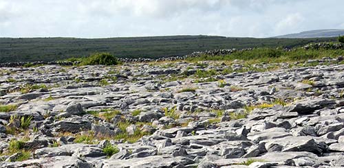
Literally the “rocky place,” the Burren is just that. This 140-square-mile limestone plateau, a ▲▲ sight, is so barren that a disappointed Cromwellian surveyor of the 1650s described it as “a savage land, yielding neither water enough to drown a man, nor a tree to hang him, nor soil enough to bury him.” But he wasn’t much of a botanist, because the Burren is in fact a unique ecosystem, with flora that has managed to adapt since the last Ice Age, 10,000 years ago. It’s also rich in prehistoric and early-Christian sites. This limestone land is littered with hundreds of historic stone structures, including dozens of Iron Age stone forts. When the first human inhabitants of the Burren arrived some 6,000 years ago, they cut down its trees with shortsighted slash-and-burn methods, which accelerated erosion of the topsoil (already scoured to a thin layer by glaciers)—making those ancient people partially responsible for the stark landscape we see today.
It’s easy to get a quick overview of this terrain as you drive through. This section’s self-guided tour begins a short drive from Doolin or the Cliffs of Moher. You can do it as a side trip from that area, or on the way north to Galway. Or take your time and really get a feel for the land with one of the walking tours described next. Travelers without a car can see the Burren with a bus tour.
Tours in the Burren
Walking Tours
Most travelers zip through the seemingly barren Burren without stopping. But hearty hikers and armchair naturalists may want to slow down and take a closer look. Be sure to wear comfortable shoes for the wet, uneven, rocky bedrock. These local guides can bring the harsh landscape to life.
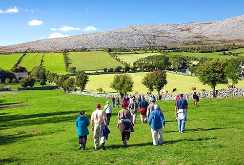
From Ballyvaughan (at the northern entrance to the Burren): Shane Connolly leads in-depth, three-hour guided walking tours, explaining the region’s history, geology, and diverse flora, and the role humans have played in shaping this landscape. This proud farmer really knows his stuff (€15, daily at 10:00 and 15:00, call to book and confirm meeting place in Ballyvaughan, +353 65 707 7168, mobile +353 86 265 4810, www.burrenhillwalks.ie).
From Carran (in the center of the Burren): Tony Kirby leads 2.5-hour “Heart of Burren Walks,” peeling back the rocky surface to reveal the surprisingly fascinating natural and human history that created this unique region. Most walks are by appointment, but scheduled walks are sometimes offered in high season; check the website for details(+353 87 292 5487, www.heartofburrenwalks.com, info@heartofburrenwalks.com).
Bus Tours
From Galway: Galway Tour Company’s standard all-day bus tour of the Burren covers Kinvarra, Aillwee Cave, Poulnabrone Dolmen, and the Cliffs of Moher (€50, departs at 10:00, returns about 18:15, confirm schedule ahead). Lally Tours runs similar day trips (see here for contact information for both companies).
Burren Drive
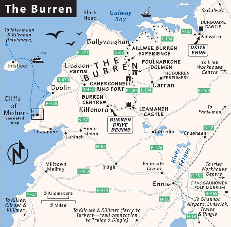
This drive offers the best quick swing through the historic Burren (and is easily done on the way to Galway). The drive begins in the middle-of-nowhere, humble crossroads of Kilfenora. Covering about 30 miles from start to finish, it takes about 1.5 hours behind the wheel, plus time for sightseeing stops. Most of the stops en route are tame (this drive is mostly about the scenery), though the Poulnabrone Dolmen is pretty thrilling (easy, free, always open, and wrapped in classic Burren landscape), and the Burren Perfumery justifiably has its fans. More importantly, the drive offers a feel for the unique geology, history, and culture of the region.
To reach Kilfenora, you can drive about 20 minutes from Doolin (various routes are possible, but it works well to first visit Lisdoonvarna, then take R-476); or about 30 minutes from the Cliffs of Moher (consider a slight detour via Doolin and Lisdoonvarna, if you’re not seeing them otherwise).
Eating: If you need lunch, there are handy cafés at the Burren Centre in Kilfenora, at the Burren Perfumery (the nicest option), and at Caherconnell Ring Fort.
Kilfenora
This town’s hardworking, community-run Burren Centre is a hub of information and local culture, with a handy lunch café (with soup, sandwiches, and light meals; at the back of the building), museum, and shop (March-Oct daily 9:00-17:00, closed off-season, +353 65 708 8030, www.theburrencentre.ie).
Near the entrance, a free exhibit explains the Kilfenora Céilí Band, a national fixture since 1909. Céilí bands play a form of Irish traditional music embellished with piano and snare drums to create the driving beat popular for set dancing, something County Clare excels in.
You can pay €8 to visit the good but overpriced museum. You’ll watch an informative 10-minute video explaining the geology and botany of the region, and then peruse the exhibits—including a replica of a fine eighth-century golden collar.
The ruined church next door (to the right, as you face the visitors center) has a couple of 12th-century crosses, but there isn’t much to see; it was recently covered with a glass roof to protect what’s left. Mass is occasionally still held in the church, which claims the pope as its bishop by papal dictate. As the smallest and poorest diocese in Ireland, Kilfenora was almost unable to function after the famine, so in 1866 Pope Pius IX supported the town as best he could—by personally declaring himself its bishop.
• To continue from Kilfenora into the heart of the Burren, head east out of town on R-476. After about 5 kilometers (3 miles), you’ll come to the junction with northbound R-480. Take the sharp left turn onto R-480, and without stopping, slow down to gaze up (on the left) at the ruins of...
Leamaneh Castle
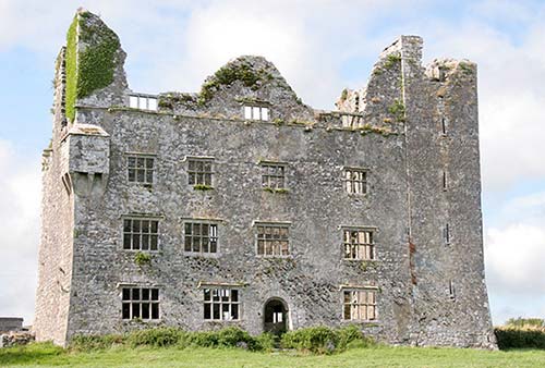
This ruined shell of a fortified house is closed to everyone except the female ghost that supposedly haunts it. From the outside, you can see how the 15th-century fortified tower house (the right quarter of the remaining ruin) was expanded 150 years later (the left three-quarters of the ruin). The castle evolved from a refuge into a manor, and windows were widened to allow for better views as defense became less of a priority.
• From the castle, continue north on R-480 (direction: Ballyvaughan). Just over a mile past the ruins, you come to a crossroads. If you’re interested in the Burren Perfumery and don’t mind an extra 20-minute drive, turn right (marked for Carran and L1014). Drive into the little town of Carran, then turn right at the end of the village and track signs for the perfumery (described next).
To skip the perfumery, keep left (on the main road) at the fork past the castle ruins. After about 8 kilometers (5 miles), you’ll hit the start of the real barren Burren. The Caherconnell Ring Fort will be on the left (skip down to that section).
▲Burren Perfumery
This classy and sweet-smelling stop comes with a fun back-story, a lesson in perfume production, and a chance to browse for unique souvenirs.
Among the Burren’s claims to fame is its remarkable diversity of fragrant wildflowers. In 1972, a botanist named Brian Mooney moved to this remote Burren home and began experimenting with local flowers, eventually distilling them into perfumes. Upon retiring, he handed the business over to Sadie Chowen, who carries on the tradition of hand-making perfumes inspired by the Burren landscape.
Visitors to this charming stone complex enjoy browsing the shop and strolling back to the original flower gardens. Try to time your visit for an informative and worthwhile 20-minute tour, which explains the production process from start to finish. You’ll learn how to smartly sample fragrances, and step into the room where they make soaps, candles, and lotions. Even if you miss the tour, you can watch a 10-minute video that ties these products to the rugged landscape. The well-stocked shop has a knack for turning sniffers into buyers.
Cost and Hours: Free, daily 10:00-17:00, June-Aug until 18:00, free tours depart 2-3/day—check schedule online, +353 65 708 9102, https://burrenperfumery.com.
Eating: The $ tea rooms feature a short but tempting menu of lunches and treats, a cozy interior, and beautiful outdoor seating.
• From the perfumery to the Caherconnell Ring Fort, you could simply retrace your route to the intersection near the castle ruins, then turn right and carry on. It’s also possible to “cut the corner” (and shave off a minute or two of driving) by taking a very narrow, steep, but scenic route over the hills. You’ll find this unmarked lane in the heart of Carran village, directly opposite Cassidy’s Pub and Restaurant. Follow this lane west about 10 minutes. You’ll crest a hill, then reach a T-intersection with R-480. Turn right to find the ring fort immediately ahead, on the left.
Caherconnell (Cahercommaun) Ring Fort
Of the many ring forts in the area, this is the most accessible. The low stone profile of Caherconnell is visible to the left on the crest of a hill just off the main road. You can park in the lot and walk up to the small visitors center and handy café for an informative 20-minute film followed by a quick wander through the small 1,000-year-old fort. You can also join a 40-minute tour (included in ticket), which is timed to coordinate with a working sheepdog demo. To learn more about ring forts before visiting, read the sidebar on here.
Cost and Hours: €8, €15.50 with sheepherding demo; open daily 10:00-17:00; sheepdog demos generally at 11:15 and 14:15, plus 12:45 in summer—check website or call to confirm; fort tours are scheduled to depart before and after each sheepdog demo; shorter hours off-season, closed mid-Nov-Feb; +353 65 708 9999, https://caherconnell.com.
• The stretch from the ring fort north to Ballyvaughan offers the starkest scenery. Leaving the ring fort parking lot, less than a half-mile away you’ll see a 10-foot-high stone structure a hundred yards off the road to the right. Pull over for a closer look.
▲▲Poulnabrone Dolmen
While it looks like a stone table, these are the remains of a portal tomb. Two hundred years ago, locals called this a “druids’ altar.” Five thousand years ago, it was a grave chamber in a cairn of stacked stones. Amble over for a look. (It’s crowded with tour buses at midday, but it’s all yours early or late.)
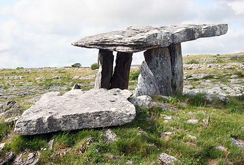
While the dolmen itself is striking, this is also perhaps your best opportunity to walk across the stony terrain and appreciate the unique Burren landscape. (Watch your step as you approach the dolmen, as all those mini crevasses can be ankle breakers.) Take this opportunity to wander about for some quiet time with the wildflowers and try to think like a geologist. You’re walking across a former seabed, dating from about 300 million years ago, when Ireland was at the equator (before continental drift nudged it north). Look for white smudges of fossils. Stones embedded in the belly of an advancing glacier ground the scratches you see in the rocks. The rounded boulders came south from Connemara, carried on a giant conveyor belt of ice and then left behind when the melting glaciers retreated north.
The Burren is a story of water, rock, geological force, and time. This 140-square-mile area supports the greatest diversity of plants in Ireland. Like nowhere else, Mediterranean and Arctic wildflowers bloom side by side in the Burren. It’s an orgy of cross-pollination that attracts more insects than Doolin does music lovers—even beetles help out. Limestone, created from layers of coral, seashells, and mud, is the bedrock of the Burren. (The same formation resurfaces 10 miles or so out to sea to form the Aran Islands.)
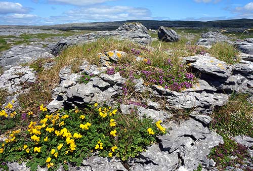
Geologic forces in the earth’s crust heaved up the land, and the glaciers swept it bare and shattered it like glass under their weight—dropping boulders as they receded. Rain, reacting naturally with the limestone to create a mild but determined acid, slowly drilled potholes into the surface. Rainwater cut through the limestone’s weak zones, leaving crevices on the surface and one of Europe’s most extensive systems of caves below. Algae grew in the puddles, dried into a powder, and combined with bug parts and rabbit turds (bunnies abound in the Burren) to create a very special soil. Plants and flowers fill the cracks in the limestone. Grasses and shrubs don’t do well here, and wild goats eat any trees that try to grow, giving tender little blossoms a chance to enjoy the sun. Different blooms appear throughout the months, sharing space rather than competing. The flowers are best in June and July.
• As you drive away from the dolmen (continuing north), look for the 30-foot-deep sinkhole beside the road on the right (a collapsed cave). From here, enjoy the next few miles of simply driving through...
▲▲Classic Burren Scenery
If you’ve been wondering, “So what’s so special about the Burren?”...just look around. For about three miles past the dolmen, you’re immersed in that jagged limestone landscape. Slow down—maybe pull over—and enjoy the views. Notice the stone fences that line the roads and demarcate property, and see how the stones are stacked not horizontally but vertically or at a sharp angle. This distinctive method helps them better withstand the battering winds of the Burren. (For more on these distinctive stone walls, see the sidebar on here.) Occasionally you’ll catch a glimpse of a cliff at the side of the road, offering a cross-section view of this stacked-limestone landscape. If you haven’t read the sidebar about this region’s distinct geology...now’s the time.
About 2.5 miles (4 km) after the dolmen, the Burren scenery crescendos as the road swings left. Use the big pullout (with a tiny information plaque) to enjoy one last view; over the next mile, you’ll leave this rocky landscape behind and descend into a lush, green valley (you can already see it around you).
• Follow that road as you depart the Burren. About a mile after the scenic pullout (or 4 miles after you left the dolmen), watch on the right for the turnoff to the...
Aillwee Burren Experience
This highly touted sight, vastly overpriced and pretty underwhelming, is skippable for most visitors. The road that twists up the hill through the grounds passes a variety of attractions, but there are two main parts: First, the Aillwee Cave, at the top of the road, is perhaps the easiest way to sample the massive underground system that underlies the Burren. A guide walks you 300 yards into the plain but impressive cave, giving a 40-minute geology lesson. Dress warmly: The cave is a constant 50°F. Farther down on the same road (closer to the main highway) is the Burren Birds of Prey Centre, which houses owls, eagles, hawks, and falcons. They run regular demonstrations; at other times, you can walk around the aviaries to see the birds up close. Ireland has better bird of prey experiences—at Ashford Castle, near Cong, and one in Dingle—but if this is your best chance, it could be worth it.
Cost and Hours: The pricey €25 ticket includes both the cave and the birds of prey, even if you only want to do one. Cave tours typically run daily in summer 10:30-about 17:00; birds of prey shows go 2-3/day; check the website for schedules and for details on their more expensive “hawk walks” (+353 65 707 7036, https://aillweeburrenexperience.ie).
• Joining N-67, you’ll leave the Burren fully behind, hit the coast, and drive through the larger town of Ballyvaughan. Stay on this main road; about 12 miles (20 km) later, you’ll reach the town of Kinvarra, which seems to be forever waiting for something to happen in its minuscule harbor. Keep an eye along the water for...
Dunguaire Castle
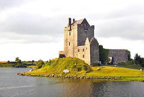
This dramatic, four-story tower house from 1520 stands a few yards out in the bay. A new company has recently assumed operation of Dunguaire; call or check online in advance before planning your visit. If it’s open, the interior is generally tourable...but it’s much more fun to come here for a touristy but fun medieval banquet (reservations required, +353 61 711 222, www.dunguairecastle.com). The evening is typically as intimate as a gathering of 50-some tourists under a time-stained, barrel-vaulted ceiling can be. Your meal (likely with wine or mead) is served amid an entertaining program of Irish tales and folk songs.
• From Kinvarra, it’s only about a 30-minute drive to Galway.
Ennis
The largest town of County Clare, Ennis (pop. 25,000), is 15 miles from Shannon Airport and can work as a first- or last-night base in Ireland for travelers not locked into Dublin flights. It also offers a chance to wander around an Irish town that is not reliant upon the tourist dollar (though not shunning it either). Ennis is also the public-transit hub for County Clare (good rail connections to Limerick, Dublin, and Galway), but onward travel to places like the Burren, Doolin, or the Cliffs of Moher is more challenging—best by tour.
Orientation to Ennis
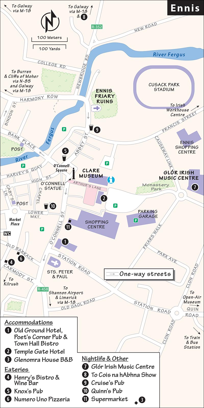
The center of Ennis is a tangle of contorted medieval streets (often one-way). Use the steeple of the Cathedral of Saints Peter and Paul and the Daniel O’Connell column (at either end of the main shopping drag, O’Connell Street) as landmarks. Muhammad Ali visited here in 2008 after discovering that one of his great-grandfathers had been born in Ennis. Locals credit his success to his fightin’ Irish side.
TOURIST INFORMATION
The TI is just off O’Connell Square, in the lobby of the Clare Museum (June-Sept daily 9:00-13:00 & 14:00-17:00, closed Oct-May).
ARRIVAL IN ENNIS
By Car: Day-trippers can park in one of several pay-and-display lots around the city center; the large one behind the Clare Museum is a handy starting point.
By Train or Bus: The train and bus station is southeast of town, a 15-minute walk from the center. To reach town, exit the station parking lot and turn left on Station Road, passing through a roundabout. Then head toward the cathedral steeple in the distance. Turn right after the recommended Old Ground Hotel onto O’Connell Street.
By Plane: Shannon Airport is about 15 miles south of Ennis (see “Ennis Connections,” later).
HELPFUL HINTS
Festival: Crowds flock to Ennis at the end of May for the Fleadh Nua (fleadh is pronounced “flah”) celebration of Irish culture, making it a challenge to find accommodations (www.fleadhnua.com).
Taxi: A good local bet is Burren Taxis (+353 65 682 3456).
Walking Tours: Jane O’Brien, who has a doctorate in history from the University of Galway, leads 75-minute walking tours of Ennis year-round (from €18, check schedule and book in advance on website, gourmet and haunted history tours also available, +353 87 648 3714, https://enniswalkingtours.com). Ollie’s Tours offers a day trip to the Aran Island of Inisheer that includes a bike tour and coffee/tea break with homemade scones (€99, April-Oct daily at 9:30, +353 86 202 3534, https://olliestours.com).
Sights in Ennis
Clare Museum
This small museum, with the TI in its lobby, offers a deep dive into the story of County Clare. While it may be of interest to history buffs, it’s pretty obscure to the casual traveler. Inside, you’ll peruse eclectic displays about ancient axe heads, submarine development, and local boys who made good—from 10th-century High King Brian Ború to 20th-century statesman Éamon de Valera (you’ll see his 1947 Dodge limo parked in the entrance hall). You’ll also learn about the Battle of Dysert O’Dea in 1318. One of the few Irish victories over the invading Normans, it delayed English domination of most of County Clare for another 200 years.
Cost and Hours: Free, June-Sept Mon-Sat 9:30-13:00 & 14:00-17:00, closed Sun, also closed Mon Oct-April, +353 65 682 3382, https://claremuseum.ie.
▲Ennis Friary Ruins
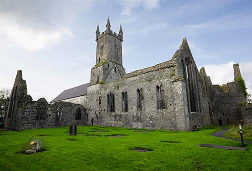
“Ennis” comes from “Inis,” meaning “Island.” In 1240, Franciscan monks built this friary (similar to a monastery) on what was then an island in the river—and the town grew up around them. Today, the mostly ruined friary is worth a look for its 15th-century limestone carvings.
Cost and Hours: €5, sometimes includes tour—depends on staffing, daily 10:00-18:00, closed Nov-March, +353 65 682 9100, https://heritageireland.ie.
Visiting the Friary: If one of the attendants isn’t too busy, they can show you around. Most of what’s worth seeing is in the nave of the ruined church—which was covered by a modern roof in 2010 to protect what remains. In the middle of the nave is a stone canopy with display cases preserving five carvings taken from the McMahon family tomb. These depict scenes from the Passion: The last one, of Jesus’ Resurrection, has a banner with a tiny swastika. But look closely: It’s reversed so that it rotates as the rising sun would. Despite the swastika’s later Nazi association, this is actually a centuries-old symbol of good luck (the word “swastika” comes from Sanskrit and means “well-being”). Visitors unaware of the symbol’s older meaning misunderstood it and tried to rub it out, thus its very faint presence today.
Now face the area that once held the altar. On the pillar to the left, you’ll see a carving of a smiling St. Francis, with an unusually distinct personality. Across the nave, near the door outside, look for an even smaller carving on a pillar, called Ecce Homo. Dating from the 15th century, this shows a crucified Jesus and is dense with symbolism (nothing on this carving is done just for the sake of decoration). For example, around the frame, you’ll see the instruments used for the crucifixion: ladder, sword, three nails, ropes, hammer, and pincers. (Posted explanations cover the meaning in greater depth.) It’s a fascinating glimpse into how illiterate worshippers 600 years ago could understand icons even though they couldn’t read.
With a little more time, you can explore outside. At the far end of the nave, exit into the ruined chancel, turn left into the sacristy (with stone-vaulted ceilings still intact), then circle through what’s left of the cloister. Then you can exit through the door near Ecce Homo, circle through the graveyard, and make your way to the back corner of the property for an uncluttered view of this historic structure.
NEAR ENNIS
▲Craggaunowen Open-Air Folk Museum
This open-air folk museum nestles in a pretty forest, an easy 20-minute drive east of Ennis. All the structures are replicas, except for the small 16th-century castle (tower house), which the park was built around. A friendly weaver, spinning her wool on the castle’s ground floor, is glad to tell you the tricks of her trade. A highlight is the Crannog, a fortified Iron Age thatch-roofed dwelling built on a small man-made island, which gives you an idea of how clans lived 2,000 years ago. A modern surprise hides in a corner of the park beneath a triangular glass roof: the Brendan, the original, humble boat that scholar Tim Severin sailed from Ireland to North America in 1976 (via frosty stepping stones like Iceland and Greenland). He built this boat out of tanned hides, sewn together using primitive methods, to prove that Ireland’s St. Brendan may indeed have been the first European to visit America on his legendary voyage, 900 years before Columbus and 500 years before the Vikings.
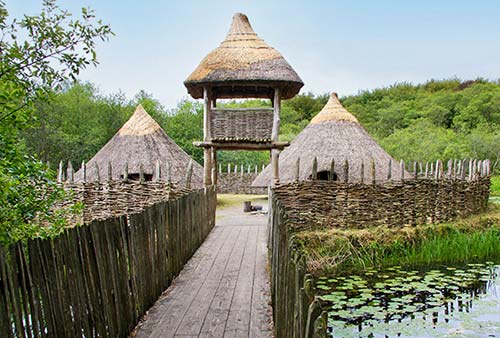
Cost and Hours: €10.95; daily 10:00-17:00, last entry one hour before closing, closed Oct-March; +353 61 711 222, www.shannonheritage.com.
Getting There: The park is well signposted 9 miles (15 km) east of Ennis off R-469, which leads out of town past the train station.
Nightlife in Ennis
Glór Irish Music Centre
The town’s modern theater center (glór is Irish for “sound”) connects you with Irish culture. It’s worth considering for traditional music, dance, or storytelling performances (5-minute walk behind TI on Friars Walk, +353 65 684 3103, https://glor.ie).
Cois na hAbhna
A show at the local Cois na hAbhna (COSH-na-HOW-na) Hall is a fine way to spend an evening. They put on a variety of performances, many featuring great Irish music, song, and dance. Check in advance to see if a céilí is scheduled (at edge of town on N-18 Galway road, +353 65 682 4276, www.coisnahabhna.ie).
Traditional Music
Live music begins in pubs at about 21:30. The best is Cruise’s on Abbey Street, with music nightly year-round and good food (bar is cheaper than restaurant, +353 65 682 8963). Other pubs offering weekly traditional music nights (generally on weekends, but schedules vary) are Quinn’s on Lower Market Street (+353 65 682 8148) and Knox’s on Abbey Street (also a recommended eatery, +353 65 682 287). The Old Ground Hotel hosts live music year-round in its pub (Fri-Sun, open to anyone); although tour groups stay here, the pub is low-key and feels authentic.
Sleeping in Ennis
Ennis has a shortage of good, affordable accommodations; my first two listings are fancy hotels that you’ll share with tour groups.
$$$$ Old Ground Hotel is a stately, ivy-covered 18th-century manse (minister’s residence) with 105 rooms and a family feel. Pan Am clipper pilots stayed here during the early days of transatlantic seaplane flights (elevator, air-con in some rooms, parking, four blocks from station at intersection of Station Road and O’Connell Street, +353 65 682 8127, www.flynnhotels.com, sales@oldgroundhotel.ie).
$$$$ Temple Gate Hotel’s 70 rooms are more modern and less personal (parking, elevator, just off O’Connell Street, in courtyard with TI, +353 65 682 3300, www.templegatehotel.com, info@templegatehotel.com).
$$ Glenomra House B&B is a tight ship run by Mary Earlie. The eight rooms are trim and bright, and it’s an easy 10-minute walk from the center of town (parking, Limerick Road, +353 65 682 0531, www.glenomrahouse.com, glenomra@hotmail.com).
Eating in Ennis
$$$ Henry’s Bistro & Wine Bar is run by friendly Dermot with attention on quality entrées, including ribeye steaks, lamb shanks, and salmon fillets. A great wine selection is hard to find in rural Ireland, but he’s got one (closed Mon, Upper Market Street, +353 65 689 9393).
$$ Poet’s Corner pub, at the recommended Old Ground Hotel, is pleasantly woody and elegant, and serves up hearty meals (daily).
$$$ Town Hall Bistro, next to the pub, does more upscale versions of Irish favorites (daily, +353 65 682 8127).
For better-than-average pub grub, I like $$ Knox’s Pub on Abbey Street (daily, +353 65 682 287). Or try one of the other places mentioned earlier, under “Nightlife in Ennis.”
The simple $ Numero Uno Pizzeria is good for an easy pub-free dinner (daily, on Old Barrack Street off Market Place, +353 65 684 1740).
The handiest big supermarket is in the sprawling Dunnes Stores, with an entrance from O’Connell Street (daily).
Ennis Connections
From Ennis by Train to: Galway (5/day, 1.5 hours), Limerick (9/day, 40 minutes), Dublin (10/day, 4 hours, change in Limerick, Limerick Junction, or Athenry). Train info: +353 65 684 0444, www.irishrail.ie.
By Bus to: Galway (hourly, 1.5 hours), Dublin (almost hourly, 5 hours), Rosslare (4/day, 6.5 hours), Limerick (hourly, 1 hour), Lisdoonvarna (5/day, 2 hours), Ballyvaughan (1/day, 2.5 hours), Tralee (6/day, 3.5 hours, change in Limerick), Doolin (5/day, 2 hours). Bus info: +353 65 682 4177, www.buseireann.ie.
SHANNON AIRPORT
The major airport in western Ireland comes with far less stress than Dublin’s overcrowded airport (code: SNN, www.shannonairport.ie). A taxi between the airport and Ennis should run about €50.
From Shannon Airport by Bus to: Ennis (bus #343 runs between the airport and the Ennis train station hourly, 30 minutes), Limerick (also bus #343, 1 hour), Galway (bus #51, hourly, 2 hours). For Dingle and Tralee, change in Limerick or Ennis (check schedules at www.buseireann.ie).
Irish Workhouse Centre
This somewhat remote sight—one of the few remaining intact workhouses in Ireland—offers perhaps the country’s best opportunity to fully appreciate the Victorian “cure” for poverty. There were once 163 such facilities across Ireland; most were either knocked down or repurposed after the country’s first step toward independence in 1922. This workhouse has been restored but not renovated: It stands, grim and foreboding, in much the same condition as when it was closed. You’ll visit the building on a 1.25-hour tour that helps bring meaning to the somber site.
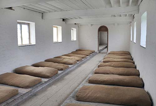
The workhouse is located in Portumna, a one-hour drive from Ennis (and not on the way to much else of interest). If this isn’t convenient for your itinerary, consider the similar but much smaller workhouse museum in County Donegal’s Dunfanaghy or the innovative, engaging shopping-mall-slash-workhouse experience in Kilkenny.
GETTING THERE
The workhouse is east of Ennis or Kinvarra (at the end of the Burren drive outlined above), just over the border in County Galway. From Ennis, it’s a rural, winding one-hour drive—stay on R-352 the entire way. As you enter Portumna, turn left at Bank of Ireland, continue on, and the Irish Workhouse Centre is on your right.
ORIENTATION
Cost and Hours: €12; open daily March-Oct, tours typically depart at 10:00, 12:00, 14:00, and 16:00—but call ahead and confirm before making the trip; closed Nov-Feb, St. Brigid’s Road, Portumna, +353 90 975 9200, https://irishworkhousecentre.ie.
VISITING THE CENTER
Workhouses were British institutions, set up by the government in the 1830s (unaware that Ireland’s Great Potato Famine was less than a decade away) to provide the poor with an alternative to starvation and death. However, as the government didn’t want the “poorhouse” alternative to be too “tempting,” punitive Poor Laws made them intentionally gruesome. Residents here essentially became voluntary prisoners: To enter the poorhouse, you had to give up any assets you still had, and while you were allowed to enter with your family, you’d likely never see them again once you arrived. Men and women were housed separately; children were also separated by gender. Children over age three were expected to work. There were no common areas for mingling.
Imagine these soul-sapping surroundings during the Great Potato Famine (detailed in the sidebar on here). As a last resort, starving people flooded into these packed quarters—but since workhouses were often not funded properly, rations were skimpy and of poor quality. Like cramped emigration “coffin ships,” workhouses became transmission points for disease among the malnourished inhabitants.
Law dictated that workhouses not compete with any local trades or businesses, and therefore they offered only the most undesirable dregs of labor, such as rock-breaking for men and corn-grinding for women. Unraveling old, worn rope and reweaving the salvageable strands into new rope was a task for anyone too weak to do heavy labor.
Life was bleak and conditions were notoriously inhumane, especially for children. Ironically, it was cheaper for landlords to pay for the boat passage of their tenants to North America than it was to keep them in poorhouses (workhouses were financed by a property tax). Another way to escape was to commit a crime: The food was better in prison, and the regimen was less strict.