FLEVOLAND
DIKE ROAD (Houtribdijk, N-307)
About a sixth of the Netherlands is reclaimed land—much of it a short drive northeast of Amsterdam. To appreciate the Dutch quest to show the sea who’s boss (and what the sea did to deserve it), visit the youngest Dutch province, Flevoland. The area is worthwhile only with a car, and far less charming than most other day-trip options. But it offers a fascinating drive for engineers or anyone else who wants to understand how the Dutch have confidently grabbed the reins from Mother Nature. It combines well with a visit to the town of Marken or Enkhuizen’s Zuiderzee Museum.
PLANNING YOUR TIME
On a day’s drive out from Amsterdam, I’d start by heading north to Enkhuizen. (For insight into the traditional lifestyles laid high and dry by the diking of the Zuiderzee, consider detouring to Marken for a stroll, or tour Enkhuizen’s Zuiderzee Museum.) Drive over the Houtribdijk (N-307) to Lelystad, and then—if time allows—continue up to the Schokland Museum. Figure about an hour from Amsterdam to Enkhuizen, a half-hour across the dike to Lelystad, a half-hour from Lelystad north to Schokland, and about an hour from Schokland back to Amsterdam (depending on traffic).
Sightseeing Tip: The Museumkaart sightseeing pass (see here) covers entry to Lelystad’s Batavialand exhibit and the Schokland Museum.
Sights in Flevoland
DIKE ROAD (Houtribdijk, N-307)
This 17-mile dike, built in 1975 as part of the Markerwaard reclamation project, is a reminder of the audacity of the Dutch vision to block off and pump out the entire inland sea. While there’s little to see, driving over it (starting near Enkhuizen and ending in Flevoland) is a novel experience. While the plan to reclaim all the land south of the dike (the floor of the Markermeer, to your right) was abandoned, this road remains a handy transportation link connecting North Holland and Flevoland and the East. At the start, ships float in a channel (hydroduct) above the road. The stone monument midway marks the joining of North Holland with Flevoland.
At the other end, a bridge deposits you in Flevoland, the only entirely reclaimed province in the Netherlands. It’s filled with bedroom communities famous for being nondescript. But it allows the residents of a densely inhabited country the option of owning a freestanding home, big garage, and piece of yard. These planned communities are designed to make Dutch suburban dreams come true, but there are tradeoffs, such as long commutes that can take a toll on family life and the Dutch free spirit.
LELYSTAD
The capital of Flevoland, Lelystad is named for the statesman who originally proposed the Zuiderzee Works. Driving around the town, it’s clear that everything was planned. The residential neighborhoods feel computer-generated and were all built at the same time. There are speed bumps on all roads, and the layout is a winding maze, making it easy to get lost. The business district attempts to spice things up with wacky modern design elements.
Batavialand
The VOC Batavia was a 17th-century sailing ship built for the Dutch East India Company. Here on the waterfront you can tour a replica and see how workers currently are building a second vessel—a replica of another 17th-century Dutch ship. You can also peek into a woodcarving workshop, a rigging workshop, and a blacksmith’s foundry. The associated museum covers the largest reclamation project in history—the “taming” of the Zuiderzee (see the sidebar in this chapter). The story of the struggle against the water is told through historic films, sound bites, models, and interactive displays. Exhibits also explore the geological evolution of Flevoland and the prehistoric people—hunters, fishermen, and gatherers—who lived here 6,000 years ago. The unusual building consists of two superimposed blocks, symbolizing the region’s interconnections between land and water.
Cost and Hours: €16; daily 11:00-17:00, closed Mon in winter; Oostvaardersdijk 1, +31 320 225 900, www.batavialand.nl.
▲▲Schokland Museum
Once a long, skinny island with a few scant villages, Schokland (about a half-hour drive northeast of Lelystad) was gradually enveloped by the sea, until the king condemned and evacuated it in 1859. But after the sea around it was tamed and drained, Schokland was turned into a museum of Dutch traditions...and engineering prowess.
Look at a map of the Netherlands. The big expanse of water in the middle was once the Zuiderzee—literally the “South Sea.” The Dutch have always had a love/hate relationship with this tempestuous sea. While it provided a convenient source of fish and trade—and an outlet to the Atlantic—the unpredictable bay also made life challenging. Over the centuries, entire towns were gradually eroded off the map.
But in 1918, the Dutch fought back and began to ingeniously tame the sea and reclaim their land with the Zuiderzee Works. The vision: to carve up what was the South Sea, bit by bit, drain it out, and turn it into dry and fertile land.
First, in 1932, they completed a sturdy dike (the Afsluitdijk) across the mouth of the sea—stretching 20 miles from Den Oever to Friesland and the northern Netherlands. This enclosed a body of water a bit smaller than Rhode Island, and succeeded in turning a dangerous, raging sea into a mild puddle.
After the Zuiderzee was diked off, the Dutch began to partition pieces of the sea floor, dike them off, and drain the water. The Noordoostpolder (185 square miles) and Flevopolder (375 square miles) were created; together, these became (in 1986) the 11th governmental province of Flevoland, with about 400,000 inhabitants—many of them older than the land they live on. An area that was once a merciless sea is now dotted with tranquil towns. The salty new seabed soil was treated organically and eventually became fertile farmland. The roads, commercial centers, and neighborhoods—made affordable to the masses—are all carefully planned and as tidy as can be.
Over time, the remaining salty water of the Zuiderzee became fresh, and in 1975, it was further divided in the middle with the 17-mile-long Houtribdijk, connecting Enkhuizen and Lelystad. This created two bodies of water: the IJsselmeer in the north and the Markermeer in the south. The eventual plan was to drain almost the entire Markermeer to create a third big polder, called the Markerwaard (160 square miles), to use for farming, residential zones, and a new airport. However, by this time, public opinion about the need for polder land had swayed. There were ecological concerns: Fishermen in villages like Urk and Marken reported that they could no longer harvest the increasingly unsalty lake, dismantling the local economy. (Nowadays, these old fishing towns host more pleasure craft than serious fishing boats.) Also, people enjoyed the Markermeer as a recreation zone and viewed it as a useful reservoir in case of drought. The Markerwaard was never built.
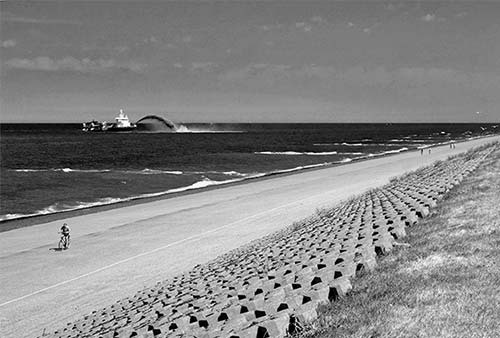
There are several places in the Netherlands to appreciate the greatness of the Zuiderzee Works. Driving over either of the big dikes—the Afsluitdijk (A-7) in the north, or the Houtribdijk (N-307), between Enkhuizen and Lelystad—gives you a sense of the scale of these projects. And actually driving around Flevoland drives home how a little country worked hard to create new land; Flevoland’s Schokland Museum and the museums in Lelystad are particularly evocative.
Cost and Hours: €8; Tue-Sun 11:00-17:00, closed Mon except July-Aug; Middelbuurt 3, +31 527 760 630, www.museumschokland.nl.
Getting There: From Amsterdam, it’s about an hour’s drive north (assuming there’s no traffic), but the trip offers travelers an insightful glimpse at Dutch land reclamation. Leave Amsterdam’s ring freeway, following signs for Almere—first southeast on A-1, then northeast on A-6. You’ll drive the length of the very flat reclaimed island of Flevoland—past the towns of Almere and Lelystad—and pass a striking line of power-generating windmills spinning like gigantic pinwheels as you cross out of Flevoland and into Noordoostpolder, the reclaimed “Northeast Polder” that includes Schokland. Take the Urk exit (#13), turn right, and follow blue signs for Schokland.
Visiting the Museum: After buying your ticket, you’ll watch a 15-minute film (press button to start in English) about the history of the town, its loss to the sea, and its reclamation.
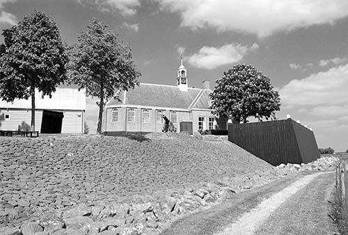
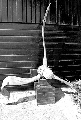
Then tour the exposition called Schokland: An Island in Time, which explains how Schokland was reclaimed as part of what would become the Northeast Polder, beginning in 1936. After being enclosed by a sturdy dike, a yearlong project drained this area of water in 1942 (while the Netherlands was occupied by the Nazis). Various Allied bombers were shot down and crashed into this area (including one whose mangled propeller is displayed just outside the museum), joining the dozens of shipwrecks that already littered the seafloor.
A model shows the full territory of the Northeast Polder, which is carefully planned in concentric circles around the central town of Emmeloord (with Schokland and another former island, Urk, creating a pair of oddball bulges in the otherwise tidy pattern).
The exhibit explains that this isn’t the first time this area has been dry land. From prehistoric times through the Middle Ages, much of what is today the Northeast Polder was farmed (many old tools have been discovered). In 1100, medieval engineers even attempted a primitive (and ultimately unsuccessful) effort to reclaim the land. Other remains from former residents include bones from mammoths and other prehistoric mammals, and a primitive 2,450-year-old canoe.
Next head into the Schokkerhuisje to learn about the people who lived here (called Schokkers) until they were evacuated in 1859. Up to 650 people at a time lived on Schokland, residing in settlements on hills called terpen while they farmed the often-flooded land below. Like the rest of the Netherlands, this little island was divided in half by religion: part Catholic, part Protestant. This museum holds artifacts from the former town of Middelbuurt. You’ll see traditional Schokker costumes (abandoned when they left the island) and a map of the entire island.
Back outside, go into the former town church, with a ceiling like the hull of a ship, a pulpit like a crow’s nest, and a model ship hanging from the ceiling—appropriate for the seafaring residents of a once nearly submerged island.
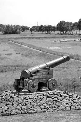
Finally, follow the path (below the church) to walk around the base of the former island—now surrounded by farm fields. When farmers first tilled their newly reclaimed soil a half-century ago, they uncovered more than just muck and mollusks. You’ll see a pair of rusty anchors and a giant buoy that used to bob in the harbor—now lying on its side and still tethered to the ground. Examine the stone dike and black wooden seawall built by residents in a futile attempt to stay above water. The post with the long blue measuring strip helped residents keep an eye on the ever-rising water level.