THE SETESDAL VALLEY
Setesdal Valley • Kristiansand
From Bergen or Flåm (via Voss) to the Setesdal Valley
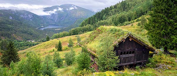
Welcome to the remote, and therefore very traditional, Setesdal Valley. Probably Norway’s most authentic cranny, the valley is a mellow montage of sod-roofed water mills, ancient churches, derelict farmhouses, yellowed recipes, lovely lakes, gentle scenery, and locals who practice fiddles and harmonicas, rose painting, whittling, and silverwork. The Setesdal Valley isn’t on the way to much of anything (though it’s a scenic byway for those heading south). But that’s sort of the point. Come here only if you have ample time, and really want to commune with time-passed, rural Norway. Those who make the journey, and really want to dig deeply into traditional Norway far from its cities and fjords, adore it.
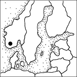
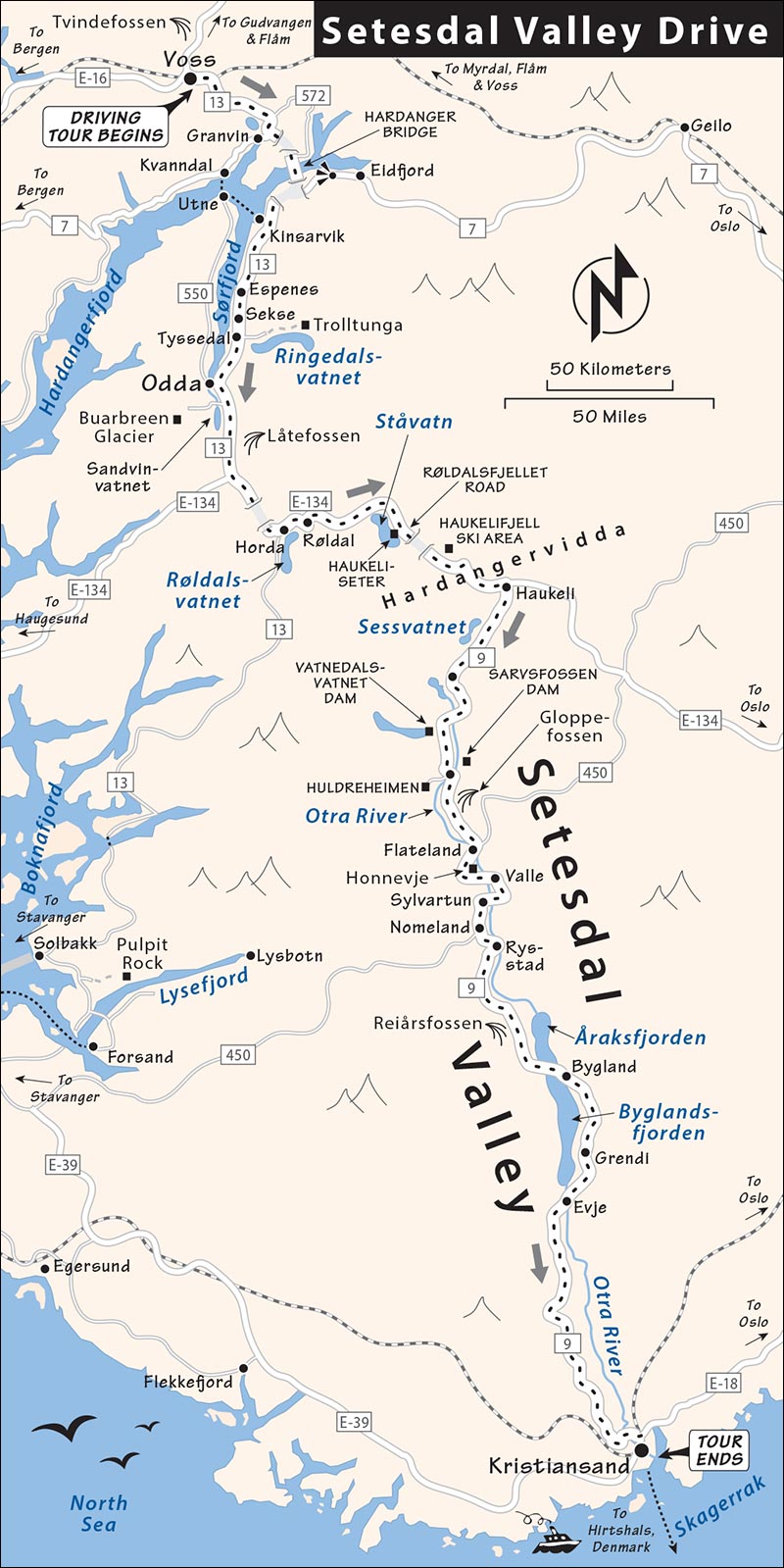
This entire chapter is structured as a self-guided driving tour, from north to south, with sights to see along your joyride. Give it a couple of days between the Sognefjord or Bergen and Kristiansand or Stavanger, and delve in. (If you’re in a rush or don’t have a car, skip it.)
For more information on the Setesdal Valley, see VisitSorlandet.com/setesdal.
Setesdal Valley Drive
On the way here from Bergen or the Nutshell zone, you’ll drive along orchard-draped fjords, past dramatic waterfalls, and through remote villages with lonesome stave churches. The Setesdal Valley itself feels dreamy and far from civilization...because it is. Then you can head onward, either to Stavanger or to Kristiansand (with its ferry connections to Denmark). I’ve covered Kristiansand—a fine if fairly dull small city that’s the most natural endpoint of this drive—at the end of this chapter.
PLANNING YOUR DRIVE
Length of This Drive: The complete drive from Bergen or Flåm to Kristiansand takes, very roughly, eight hours of driving—not counting stops or delays. (Add about an hour to end in Stavanger.) The best places to stay overnight are Hovden and Bykle, along the most scenic one-hour, 40-mile stretch of the Setesdal Valley, a little more than halfway through the drive (allow 5-6 hours to get there).
Day 1: Head south along the lovely Sørfjord and pass the spectacular Låtefossen waterfall, enjoying enticing peeks of glaciers and stave churches as you twist over mountain passes and through humble villages. Overnight in Hovden or Bykle.
Day 2: Spend most of the day exploring the Setesdal Valley. Leave plenty of time for dreamy nature walks, exploring sod-roofed settlements, and taking in lakes-and-pine-trees scenery. After Rysstad, you can make good time getting to your next destination: Figure about two hours to Kristiansand, or three hours to Stavanger, with fewer stops to tempt you en route.
From Bergen or Flåm (via Voss) to the Setesdal Valley
Begin in either Bergen or Flåm (in the heart of the “Norway in a Nutshell” area).
BERGEN OR FLÅM TO THE SØRFJORD
From Bergen or Flåm, take the main E-16 highway to Voss (about 1.5 hours from Bergen, 1 hour from Flåm). From Flåm, you’ll drive through Gudvangen, pass the optional detour to the Stalheim Hotel viewpoint, and keep an eye out for the Tvindefossen waterfall on your right as you approach Voss.
Then, from Voss, follow highway 13 south, signed for Oslo and Odda. About 30 minutes after leaving Voss—soon after you drive along Lake Granvinsvatnet—you’ll head into a five-mile-long tunnel. Be ready: While you’re still inside the tunnel, near the far end, you’ll come to a big subterranean roundabout, where you’ll turn right to continue following signs on toward Odda (on highway 13)—also signed for Oslo.
You’ll pop out into daylight just before you cross the longest suspension bridge in Norway, Hardanger Bridge, spanning the Hardangerfjord. Immediately over the bridge, you’ll enter another tunnel. At the roundabout inside the tunnel, carry on straight (highway 13 toward Odda) to follow the route below.
Scenic Detour: For a view of the bridge, turn off here for Oslo, drive a couple of minutes to a viewpoint (with a WC) for a quick look, then return to the tunnel and get back on highway 13 to Odda.
Sørfjord
Emerging from the tunnel on highway 13, you’ll spend the next 30 miles or so driving along the extremely long Sørfjord—a branch of the Hardangerfjord. Enjoy the scenery, but keep an eye on the road—which has some one-lane stretches with pullouts for oncoming traffic.
After the inlet around the town of Kinsarvik, around Lofthus, you enter orchard country: Tidy rows of fruit trees stripe the hills above and below the road, giving the fjord a Lake Geneva feel. Watch for roadside stands where you can pick up some fresh fruit with a glorious fjord backdrop. At the Espenes park pullout is a futuristic picnic area with silvery canopies (and WCs)—one of several tempting fjordview picnic spots you’ll pass between here and the end of the fjord. The village of Sekse is “sekse” indeed—on a slinky promontory draped with orchards and speckled with houses.
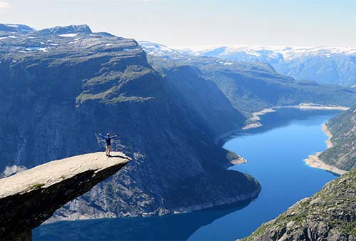
After several tunnels, with peek-a-boo views over the fjord, the town of Tyssedal is marred by heavy industry down by the waterline. As you come into town, you’ll pass the turnoff for the Norwegian Museum of Hydropower and Industry (www.kraftmuseet.no). Then, just beyond, a road turns off on the left to twist up to the trailhead for the dramatic hike up to the Trolltunga, a climb to a stony “troll’s tongue” promontory that jabs out high above a lake. (You can’t see it from the road.) This classic hike—now “Instagram-famous” because of its dramatic views—is demanding but thrilling: a 14-mile round-trip with an elevation gain of over 2,600 feet (www.trolltunga.com).
Continuing along highway 13 to the fjord’s end, you’ll pass a huge zinc and copper industrial plant across the water. Why so much heavy industry in this otherwise pristine setting? In Norway, water plus gravity equals electricity, industry, and money.
In a few moments, we’ll see a high-mountain lake, then come into the larger town of Odda—popular mainly as a home base for those hiking the Trolltunga path (TI on market square at Torget 2, +47 48 07 07 77, www.visitodda.com [URL inactive]). Driving through the old town center along the waterfront, bear left to stay on highway 13.
As you drive through Odda, notice you’re heading uphill, along the big Opo River that connects a lake up ahead to the fjord you just left—the perfect location for industry.
Exiting Odda and continuing on highway 13 toward Røldal, you’ll begin driving along the long, skinny, fjord-like lake called Sandvinvatnet. Watch for the second of two unmarked pullouts about a half-mile out of town, once you’ve started along the lake. From this viewpont, you can gaze across the lake at the U-shaped valley and the Buarbreen glacier up top.
Glacier Detour: If instead you’d like to hike up to the Buarbreen glacier tongue, at the end of town you can turn right toward Buer and Buarbreen, drive four miles, park at the Buer restaurant near the dead-end of a valley road, and hike about an hour (details at www.buarbreen.no).
ODDA TO THE SETESDAL VALLEY
Leaving the lake behind, drive into the land of boulders. The many mighty waterfalls that line the road, gushing into a wide river, seem to have hurled huge rocks (with rooted trees) into the rivers and fields.
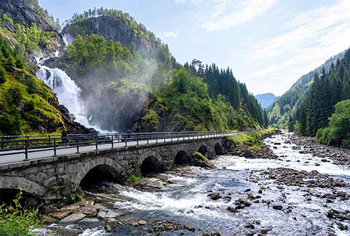
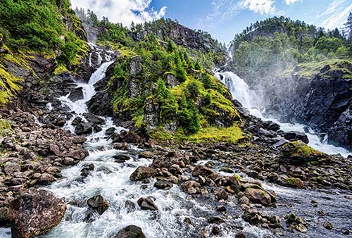
For the ultimate expression of all those boulders and gushing water, about five miles past the end of the lake, stop at the giant double waterfall called Låtefossen (on the left, parking on the right, drive slowly through it if you need a car wash). Worth ▲▲ and one of the most impressive sights on this entire drive, this churning cascade is cleft in the middle by a burly mountain of rocks, moss, and trees, all continuously spritzed in mist. These falls are a magnet for every tourist within dozens of miles, creating a traffic jam on an otherwise quiet and remote-feeling stretch of road. Continuing past the parking lot, just beyond is yet another beautiful waterfall on the right, which pales only in comparison to the grand Låtefossen.
A couple of miles after the falls, watch for the right turn over the bridge to stay on highway 13. You’ll twist up into the hills and reach a T-intersection; turn left on E-134 and highway 13 toward Røldal.
After a few miles, you’ll see a turnoff on the left to take the scenic, twisting Røldalsfjellet road over the mountains. You’ll see many of these scenic byways throughout Norway—allowing drivers to take the “old road” that has been replaced with modern, view-less tunnels. Taking scenic detours adds miles, time, and whiteness to your knuckles; if you’re trying to make good time, you should resist most of them. (Stay on the main road here to save about 15 minutes.)
Soon, whether you’re exiting the longest tunnel on the main road (or rejoining from the Røldalsfjellet), you’ll corkscrew past some ski lifts, entering winter-sports country and a high-end resort zone. Doing a rare complete 360-degree turn inside another tunnel, you’ll drop into down into the village of Horda, on a beautiful lake called Røldalsvatnet. Stay straight to remain on E-134 (eastbound, toward Røldal).
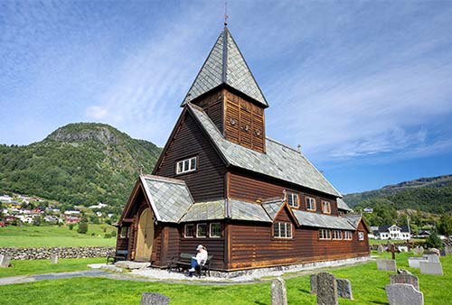
After cruising above the Røldalsvatnet (and going through some avalanche tunnels), you’ll pull into the pleasant old town of Røldal. If you’re a stave church aficionado, turn off on the right after the Shell station (marked Røldal Stavkyrkje) to see one. Built in the early 13th century, this church had several waves of modifications and restorations—leaving it feeling simple outside and beautiful but less typical of stave churches inside (with pews, a decorated altar area, and lots of paintings on the walls; small fee, open daily in summer, www.stavechurch.com/roldal-stave-church).
Leaving Røldal, you’ll twist up E-134 and cross the Hardangervidda plateau. Here you feel high above it all, in a rocky and treeless terrain, interspersed with tunnels. Lakes are like frosted mirrors, making desolate huts come in pairs. A 3.5-mile tunnel plunges you into darkness again before you reemerge into the desolate landscape. A few miles later, watch on your right for a rest stop to stretch your legs, with WCs and pretty views over Ståvatn lake. A mile beyond is Haukeliseter—a group of sod-roofed buildings filled with cultural clichés and tour groups, offering light food in a lakeside setting.
Carry on, enjoying the “top of the world” feeling. Another long tunnel deposits you in a similar landscape, but with a few scrubby trees—a sign you’re dropping back down into a valley. You’ll pass Haukelifjell, a little ski resort area with a whole city of sod-roofed huts.
The trees get bigger as you follow rocky waterfalls downhill toward the Haukeli transportation junction. (If you need provisions, there’s a supermarket just beyond the turnoff.) Here you’ll leave E-134 and turn right over the bridge onto highway 9 (toward Evje and Hovden) to wind back up into the mountains—with sweeping views over the hills and lakes below. Summiting, you cruise across a mossy plateau, passing high-mountain lakes; the biggest is Sessvatnet, at 3,000 feet, with sod-roofed log cabins for fishermen huddled around the shoreline.
Continuing slightly downhill, you’ll officially enter the...
Setesdal Valley
From here, you’ll follow the Otra River downhill for 140 miles south to Kristiansand. The best, most scenic, and most traditional part of the Setesdal Valley stretches about 40 miles from Hovden to Rysstad.
The valley is famous for its filigree jewelry, made to adorn traditional costumes and echoing the rhythmical designs of the Viking era and Middle Ages. Each town has a weekly rotating series of hikes and activities for the regular, stay-put-for-a-week visitor. The upper valley is dead in the summer but enjoys a bustling winter.
The Setesdal Valley joined the modern age with the construction of this highway in the 1950s. All along the valley you’ll see two-story storage sheds called stabburs (the top floor was used for storing clothes; the bottom, food) and many sod roofs. Even the bus stops have rooftops the local goats love to munch.
Local nature walks offer you a chance to see reindeer, moose, arctic fox, and wabbits—so they say. Berry picking is popular in late August, when small, sweet blueberries are in season. Hunting season for reindeer starts in late August (only in higher elevations) and later in the fall for grouse and moose (elg).
As for the route: You’re basically following highway 9 the entire way. If you get turned around, just follow signs toward Evje (the big town at the bottom of the valley). Skip the secondary routes, which are rarely worth the extra miles.
Hovden
A ski resort at the top of the Setesdal Valley, Hovden (pop. 400, elevation 2,500 feet) is relatively quiet in summer, and a bit short on charm, but is big enough to make for a handy home base. If heading south along this drive, sleeping here lets you hit the best part of the Setesdal Valley when you’re fresh the next morning.
The town huddles along the churning Otra River and many rocky waterfalls. As you drive through the center, watch on the right for the big, hulking Hovdetun building—a shopping mall with sports and souvenir stores, a Vinmonopolet, and the TI (open daily in high season, closed Sun outside of summer, www.hovden.com). At the TI, you can ask for the door code for the Museum of Iron Production (described below).
Sights and Activities: If you have time to spend here, hiking and mountain biking are popular (the TI and hotels can offer suggestions and maps). For a quick stroll through some fine scenery, simply follow the gravel path along the river through the heart of town. It’s easiest to pick up this trail at the far end of town, on the right, where the Hengi Beach zone is full of summer fun (sandy swimming cove, boat rentals, playground, volleyball, beach bar, and so on). From here, you can follow the trail north up the river for as far as you like. Posted info plaques tell you more about the town’s geology and history, mainly focusing on the Viking Age. And just a couple of minutes up the trail, you’ll reach the endearing Museum of Iron Production (Jernvinnemuseum), where you can learn about how residents since the Vikings have been ironworkers (free—if it’s locked, get door code from Hovden TI).
If you follow the riverside path (or drive along the main road) north to the traffic bridge, you’re getting close to Hovden’s impressive indoor/outdoor swimming-pool complex, with lots of hot-water fun—a tempting place to unwind from a long day of driving or hiking (www.badeland.com).
Farther above town is an alpine center. While designed mainly for skiing, its lifts often run in the summer for visitors seeking a high vantage point over town (or to ride down on a mountain bike).
Sleeping and Eating in Hovden: $$$$ Hovdestøylen is a spiffy and upscale retreat, with 32 rooms and 32 apartments in a mountain-mod lodge with cozy lounges and a good $$$$ restaurant, all overlooking the river (with easy access to the riverside trail). They also have several sod-roofed and modern cabins, both nearby and elsewhere in town (+47 37 93 88 00, www.hovdestoylen.com). $$$ Hovden Fjellstoge is a big ski chalet complex with 50 rooms and apartments scattered through several buildings, plus eight stand-alone cabins. It’s less central, a couple of miles before town, along the main road (+47 37 93 95 43, www.hovdenfjellstoge.no).
HOVDEN TO BYKLE
Leaving Hovden, you enter the most scenic stretch of the drive: moss-covered rocks, tall and scrubby pine trees, and water, water everywhere. Driving through the valley, you’ll understand why hydroelectric power has made the surrounding Bykle municipality one of Norway’s wealthiest. (With fewer than a thousand people in the entire municipality, the per-capita wealth is off the charts.)
For a closer look at this local industry, nine miles south of Hovden, take a two-mile side-trip (turn right at the sign for Dalen and Dammar, then left at the Dammar sign) to the 400-foot-high rock-pile Vatnedalsvatnet Dam. Here you’ll enjoy a great view over the tree-filled valley below, not to mention an impressive rockery. Ponder the vastness of Norwegian wood...and the staggering potential energy of all this water, up high in the mountains. (Remember: Water plus gravity equals electricity and money.)
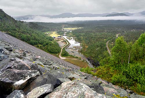
Back on the main road, carry on another eight miles or so to Bykle. Enjoy the rocky river views, and watch for modern sluices that help manage the flow of water.
Downstream, the river widens. To see the reason why, turn left just as you enter Bykle (signed for Stavenes and Dam Sarvsfossen) to see the Sarvsfossen Dam. While constructed of modern concrete, it’s still a striking sight—165 feet tall and neatly wedged between cliffs of red and gray rock. You can drive across the top of the dam to the far side for a great view back.
Next up, you’ll pull into blink-or-you’ll-miss-it town of...
Bykle
The teeny town of Bykle (pop. 250)—a wide spot in the road—comes with three traditional Setesdal sights: two right along the road, and another high up on the hill above. All three are part of the Setesdal Museum, and open only short hours in the peak of summer (mid-June-Aug, www.setesdalsmuseet.no). But even when closed, you can see them from outside.
On the right side of the main road are the turf-roofed cabins of the Lislestog open-air folk museum. Notice that the roofs aren’t just sod—there are actual trees growing from them. As far as log-cabin folk museums go, this is as good and as handy as any we’ll pass on this drive—so if it’s open, pay the modest entry fee and poke into the buildings.
Across the road is the most interesting church (gamle kyrkje) in Setesdal—tiny like the town, all white, and with a sharp, pointy roof and two balconies—one for men and one for women. This 17th-century church was used for services until 2004, when the bigger, modern church was built just downhill.
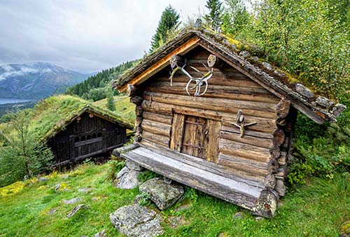
High on the hill above town is Huldreheimen, an over-the-top, cutesy-traditional sod-roofed log-cabin vacation retreat built in the late 19th century by an Oslo doctor and his actress wife. To get there, drive up the steep road at the entrance to town, past the Bykle Hotell, then keep following signs on up. From the parking area, you’ll hike steeply uphill, following signs past a forest to a moss-covered knoll with grand views over the lake-filled valley below. The smattering of split-log buildings—with giant stone-slab thresholds and stag antlers over every door, and tree saplings growing from the roofs—is classic Setesdal, and worth the effort to reach.
Sleeping and Eating in Bylke: $ Bykle Hotell, proudly family-run by Bjørn and Hanna, has 19 rooms and seven apartments in a traditional but updated building just above the main road. You can choose between old-fashioned rooms, with wooden furniture and creaky floors, or modern ones for the same price. This is cozy and a great value when compared to the pricey ski resorts in Hovden (+47 97 57 37 23, www.byklehotell.no). Their $$$ restaurant is open for dinner nightly, and serves a late lunch on Sundays.
BYKLE TO VALLE
Continuing from Bykle, you’ll drop down into a Norwegian Romantic painting and drive along a pretty Bob Ross lake—and then, for good measure, a few more. Gargantuan gray cliffs tower overhead, and tunnels make the driving easy. A few miles on, watch for a dramatic gorge on your right as you zip down the valley. Notice how even the cute bus stops have sod-roofed, log-cabin waiting huts.
Along this road, you’ll cross into the next municipality—from Bykle to Valle. And, while Bykle’s claim to fame is hydroelectric engineering and ironworking, this part of the Setesdal Valley is particularly known for its silver, today used in local folk costumes...and souvenirs.
About nine miles after leaving Bykle, consider a short, scenic byway on a gravel road along the water: At the sign for Sanden Såre Camping, exit onto a little road that runs through an idyllic campground, with tranquil Norwegian views over rocks, trees, and water. Drive slowly, being careful not to disturb the campers. Along this side road (or up on the main road), you’ll also cross the Gloppefossen, a mildly pretty waterfall.
Just after the campground road rejoins the main road, watch for a bus stop pullout at a suspension bridge—you can walk out for a bounce, but there’s a better bridge coming up soon in Valle. (Just beyond, before Flateland, I’d skip the turnoff for the Rygnestad Museum—the folk museum in Bykle is better.)
A couple of miles later, it’s worth pulling out (on the left) at Honnevje, a nice picnic and WC stop. You can walk out across the flat, slippery-when-wet rocks and over bridges for your choice of views. This area also has a popular dock for swimming...for hot-weather days or polar bears.
Next up is the town of Valle; you’ll pass the main commercial center on your left, about a mile beyond the Honnevje rest area.
Valle
Valle (pop. 290) is Setesdal’s most scenic village (but don’t tell Bykle). The setting is grand, facing a towering, sheer cliff in one direction, and pretty forested hills in the other. The town itself is basically a bunch of big buildings above the road. In the hulking roadside building, watch for the good $$ Nordibø Landhandel—a cute-inside café with good coffee, decent lunches, and lots of local products (open daily until 18:00). Nearby is a big Co-op/Prix grocery store, with a Joker across the way (both closed Sun). A playground fills the park in the heart of town.
On the upper street, you’ll find a gas station; the library (bibliotek) with the TI and WCs inside (typically open weekdays only); and the Hasla silver shop.
A short walk across the main road (also signposted for drivers zipping through) is the Prestefossen Hengebru suspension bridge, which attracts kids of any age (b-b-b-b-bounce), and anyone interested in a great view over the river to strange mountains that look like polished, petrified mudslides. European rock climbers, tired of the over-climbed Alps, often entertain spectators with their sport.
VALLE TO RYSSTAD
South of Valle, the area has a lot more logging (and is less scenic). About seven miles south of town, watch on the left for the riverside Sylvartun silversmith shop, housed in a 17th-century, grass-roofed log cabin next to the main road. If it’s open (sporadic hours in summer), you can tour a small exhibit on local folk culture.
To Stavanger: If you’re headed to Stavanger, immediately after Sylvartun, in Nomeland, watch for the turnoff signed for Sandnes, Sirdal, Suleskard, and Brokke (not signed for Stavanger). You’ll take road 450 for about 2.5 hours as it winds westward through several small communities, then pick up E-39 at Ålgård and follow it north the last 30 minutes into Stavanger (figure 110 miles and 3 hours total).
To Kristiansand: If Kristiansand is your end point, carry on soon after Sylvartun and the Stavanger turnoff, to reach the town of Rysstad. It feels charming and traditional, with a mix of modern buildings and sod-roofed houses (plus a pretty church) along the road. Near the start of town, on the right, is the easy-to-miss turnoff for the Setesdal Museum (worth a visit for deep-divers into Setesdal culture but less engaging than the sod-roofed huts you’ve been visiting in the wild, www.setesdalsmuseet.no).
Near the end of Rysstad, just after the tidy graveyard, is Sølvgarden (“Silver Garden”), filling an over-the-top folksy house by the side of the road. Inside you’ll find a silver shop, an inviting $$$ restaurant serving lunch and dinner daily, and a $ hotel with 23 rooms (a workable home base for the region, but too far south to be particularly handy; www.solvgarden.no).
RYSSTAD TO KRISTIANSAND
Leaving Rysstad, the valley opens up significantly, and the remoteness and richness of the folk culture begin to fade. If you’ve been busy stopping and sightseeing, this is a good time to make up some serious time on your way to Kristiansand (about 80 miles and 2 hours away).
About 15 miles south of Rysstad, watch high on the cliff above for the Reiårsfossen waterfall. While dramatic by most standards, it ranks fairly low on the list of sights we’ve seen along this drive; you may even want to just zip right past its pullout.
From here, the road traces first the west shore of the freshwater Åraksfjord, with pretty views across the water to the village of Åraksbø.
Next you’ll follow the east shore of the long and scenic (and also freshwater) Byglandsfjord, passing the town of Bygland—with a pretty tree-lined park poking out into the fjord. You’ll follow the waterfront road about 12 more miles, past a few more appealing waterfront rest stops. Enjoy the views of rocky, tree-topped islets out in the water.
At the end of the fjord, in Grendi, the Årdal Church (1827) has a rune stone in its yard (directly in front of the main door—though the information panel is as faded as the stone itself). Three hundred yards south of the church, where the river empties into the fjord, stands an oak tree that’s supposedly 900 years old.
Soon after, the Revsnes Hotell (at the entrance to the town of Byglandsfjord) is notable as the starting point for the Bjoren, an 1867 wood-fired steamship that still takes visitors on sightseeing trips in the summer (get details at hotel). At the end of the fjord is another beefy dam, which directs the Otra River into some rapids as it carries on downhill.
A pretty church marks your entrance to Evje—a huge town by Setesdal standards (pop. 3,500). This area is famous for its gems and mines. Fancy stones fill the shops here. The Setesdal Mineral Park, a modest amusement park for kids, is on the main road, two miles south of town (www.mineralparken.no).
From Evje, it’s about an hour’s drive (under 40 miles) to this region’s transportation hub and the end of our drive, Kristiansand.
Kristiansand
The “capital of the south” and Norway’s fifth-biggest city (pop. 115,000), Kristiansand isn’t worth jumping ship for. But if you find yourself in Kristiansand—at the end of a scenic Setesdal Valley drive, en route to a Denmark-bound ferry, or on a cruise ship—it can pleasantly fill a few hours.
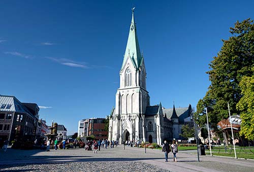
King Christian IV founded the city that bears his name in 1641, gracing it with a grid-plan layout. Today Kristiansand feels like a low-key miniature Oslo, with a fortress overlooking the harbor; slick new residential and office development (including a snazzy opera house) along the shore; and a tidy, if sterile, downtown core. It also has a dramatic Neo-Gothic church towering over a delightful city-center park, and an old town (Posebyen) with low-rise, shiplap buildings.
Arrival in Kristiansand: Drivers find lots of parking garages and light traffic in the downtown core (ask your hotel for advice). The train station is at the western edge of the city center, less than a 10-minute walk from the cathedral. Cruise ships arrive across from the slick concert hall; walking along the pier, you’ll quickly reach the Fiskebrygga harbor development. From here, it’s easy to walk either along the waterfront or up into the town center.
Visiting Kristiansand: The heart of Kristiansand is its Neo-Gothic cathedral (Domkirke), which jabs up from a pretty square in the heart of the city. It’s worth a look inside the austere Lutheran interior, with a soaring wooden nave supported by raw-wood, stave-like pillars. The grand organ (with frequent free recitals) fills a giant loft over the door, but is played from a keyboard in the middle of the church—as if to emphasize the importance of music in Lutheran worship. Outside, church bells chime merrily.
On the main square in front of the church, you’ll find the City Hall (with the “TI”—a few racks of free brochures and maps—inside; www.isitkrs.no [URL inactive]), a gurgling fountain, a pretty park (Wergelandsparken), WCs, and plenty of appealing outdoor cafés and restaurants nearby.
From the square, you can head northwest a couple of blocks to poke around the Renaissance-era old town, Posebyen, with (mostly white) shiplap houses. Or head in the opposite direction, along the street by the cathedral, to find Markensgate. This pedestrian street, though a bit sterile, is lined with shops, cafés, restaurants, and great people-watching.
From anywhere in the city center, it’s just a few easy blocks down to the waterfront for a stroll along the Strand Promenaden. The centerpiece is the big, round, dull Christiansholm Fortress, surrounded by a view terrace with cannons and views over the harbor. In both directions, you’ll find big, grassy parks; wide trails for bikes and pedestrians; and lots of leisure craft moored in protected harbors. In summer there’s a Ferris wheel. North of the fortress is the big city beach, facing a row of high-end new condos.
But it’s more interesting to walk in the other direction (south, with the water on your left), then find the walkway under the bridge, to reach the delightful Fiskebrygga (“Fish Wharf”). This modern yet charming harbor zone, with colorful buildings linked by waterways, boardwalks, and footbridges, is anchored by an indoor fish market (Fiskebasaren, “Fish Bazaar”) with eateries inside. In the surrounding area, numerous restaurants offer a pleasant waterfront atmosphere.
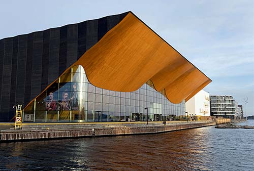
From here, you can see the corner of Kristiansand’s dramatic Kilden Performing Arts Center, a state-of-the-art, architecturally bold concert hall with a glass facade and a wavy roof. This area merits an exploratory stroll. Cruise ships dock just across the canal from here.
Just beyond this area, the rocky point called Odderøya has nature trails for getting out of the city. If you have lots more time to spend, Kristiansand also has a big park behind downtown (Ravnedalen), an open-air museum (at Kongsgård), a large zoo, and lots of other attractions.
Sleeping in Kristiansand: With many business travelers, the town center is loaded with big, predictable, comfortable chain hotels. I’ve slept well at the basic but solid $$$ Thon Hotel Parken, a few steps from the main square (Kirkegate 15, +47 38 17 20 40, www.thonhotels.no).
Eating in Kristiansand: It’s easy to find a meal here. The two most appealing outdoor areas—with lots of eateries to choose from—are the Fiskebrygge harbor complex down along the water, or up in the town center, in the streets near the cathedral.
Kristiansand Connections: Trains connect to Stavanger (5/day, 3 hours) and Oslo (5/day, 4.5 hours). Kristiansand is also a hub for ferries to Hirtshals, Denmark, operated by two companies: Color Line (2/day year-round, more in summer, 3.5 hours, www.colorline.com) and Fjordline (1-2/day in summer, none in winter, 2.5 hours, www.fjordline.com [URL inactive]). Reservations are smart. You can either drive on or walk on.