DURHAM & NORTHEAST ENGLAND
Durham • Beamish Museum • Hadrian’s Wall
Sleeping and Eating near Hadrian’s Wall
Northeast England harbors some of the country’s best historical sights. In the university town of Durham, tour the thousand-year-old-castle-turned-student-dormitory and marvel at England’s greatest Norman church, and pause to savor an evensong service. Go for a ramble along Hadrian’s Wall, the northwest frontier of the Roman Empire 2,000 years ago, when Britain was a colony. At the excellent Beamish Museum, travel back in time to the 19th and 20th centuries.
PLANNING YOUR TIME
For train travelers, Durham is the most convenient overnight stop in this region. Durham also works well as a day trip from York (frequent one-hour trains) or as an on-the-way stopover between destinations (for baggage storage, see “Helpful Hints,” later). If you like Roman ruins, Hadrian’s Wall is workable by public transportation but requires some effort (and extra time). Beamish Museum is an easy day trip from Durham (less than an hour by bus).
By car, you can easily visit everything in this chapter in three busy days.
An efficient plan is to spend a night in Durham and a night near Hadrian’s Wall, stopping at your choice of other sights between them. For example, you could reach Durham in the early afternoon, in time to tour the cathedral and castle/university, then enjoy the evensong before dinner. After sleeping in Durham, head north, stopping at Beamish before curving west to Hadrian’s Wall. One overnight near the wall is enough to visit one or two museums and take a quick historic hike, before moving on to your next destination in the afternoon.
Serious hikers might appreciate two (or more) nights near Hadrian’s Wall to see more sights, walk more of the wall, and improve the odds for some decent weather.
Durham
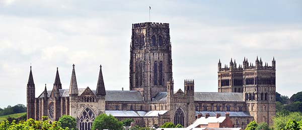
Without its cathedral, Durham would hardly be noticed. But this magnificently situated structure is hard to miss. Seemingly happy to go nowhere, Durham sits along the tight curve of its river, snug below its castle and famous church. With a cluster of tightly packed old buildings on a narrow, steep promontory, it has a medieval, cobbled atmosphere and a scraggly peasant’s indoor market just off the main square. Durham is home to England’s third-oldest university, with a student vibe jostling against its lingering working-class mining-town feel. It’s also unusually green: Both banks of the river are thickly wooded...making it very easy to escape into nature.
Orientation to Durham
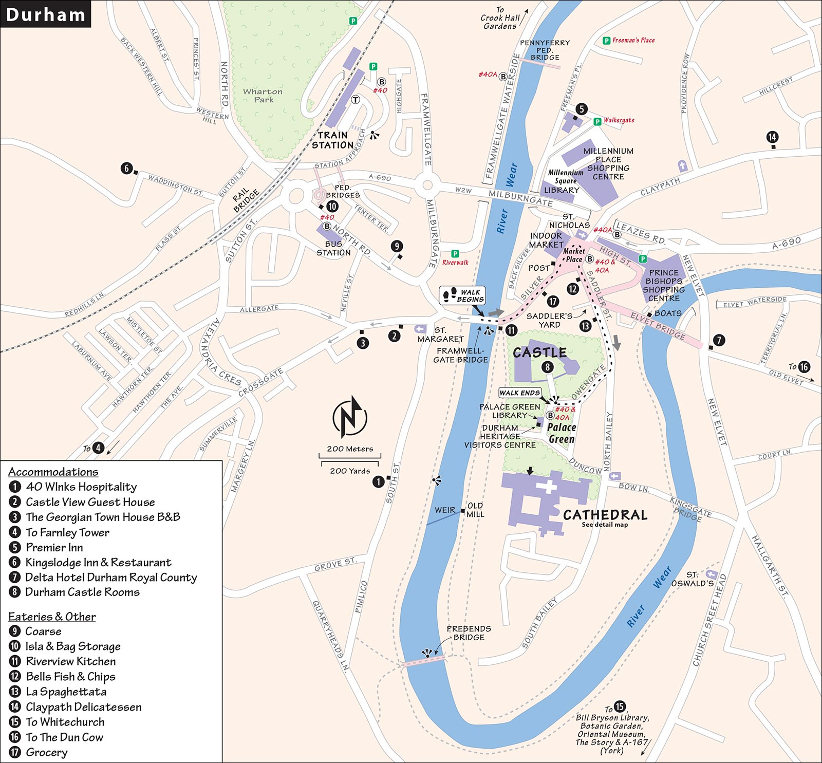
As it has for a thousand years, tidy little Durham (pop. 57,000) clusters everything safely under its castle, within the protective hairpin bend of the River Wear. Because of the town’s hilly topography, going just about anywhere involves a lot of up and down...and back up again. The main spine through the middle of town (Framwellgate Bridge, Silver Street, and Market Place) is level to moderately steep, but walking in any direction from that area involves some serious uphill climbing. Take advantage of the handy Cathedral Bus—especially up to the cathedral and castle area, or to the train station.
TOURIST INFORMATION
Durham does not have a physical TI, but the town maintains a call center and a useful website (calls answered Mon-Fri 9:00-17:00, +44 3000 262 626, thisisdurham.com, visitor@thisisdurham.com).
During peak season, volunteer Durham Pointers staff a tourist information cart in Market Place near the equestrian statue. They hand out free maps of the city, prepare a weekly list of current hours and what’s on (downloadable from their website), and offer unbiased advice on Durham attractions; look for the pink vests and tell them Rick Steves sent you (Easter-early Oct Mon-Fri 9:30-15:30, Sat-Sun 10:00-14:30, +44 7582 332 621, durhampointers.co.uk).
ARRIVAL IN DURHAM
By Train: Durham’s small station has just two platforms. (From platform 2, you’ll need to take the stairs under the tracks, following City Centre signs.) Out front, the stop for the Cathedral Bus—the fastest and easiest way to reach the cathedral—is on the roundabout to the left (see “Getting Around Durham,” below).
But if you have time, the walk through town is pleasant, and you can pick up my self-guided walk halfway along, at Framwellgate Bridge. (Figure about 10 minutes’ stroll to the bridge, then another 10 minutes up to the cathedral.) Exit the station and follow the road curving to the right downhill. Take the second pedestrian turnoff on the left (within sight of the railway bridge), which leads almost immediately over a footbridge above busy road A-690. Twisting down the other side (past the baggage storage shop, see “Helpful Hints,” below), take North Road into town to reach hotels, the river, and the cathedral.
By Car: Drivers simply surrender to the wonderful 400-space Prince Bishops Shopping Centre pay parking lot (coming from the A-1/M-1 exit, you’ll run right into it at the roundabout at the base of the old town). An elevator deposits you in the heart of Durham (closed midnight-6:00, a short block from Market Place, +44 1913 750 416).
HELPFUL HINTS
- Markets: The main square, Market Place, has an indoor market (generally Mon-Sat 9:00-16:30, closed Sun) and hosts outdoor markets (Sat retail market generally 9:00-16:00, farmers market third Thu 9:00-15:30; +44 1913 846 153, durhammarkets.co.uk).
- Baggage Storage: The Dot Com shop stores bags for a reasonable price (Mon-Fri 9:00-17:30, Sat until 17:00, closed Sun, 50 North Road, +44 191 375 7520).
- Tours: A handful of outfits in town sporadically offer town walks, ranging from basic history tours to ghost walks. Check with the Durham Pointers or search online for the latest offerings. One reliable choice is Peter from Walkabout Durham, who offers both shared and private tours (walkaboutdurham.com).
GETTING AROUND DURHAM
The convenient Cathedral Bus makes short work of Durham’s hills. Bus #40 runs between the train station and the cathedral, stopping at the bus station, Market Place, and Palace Green (£1 all-day ticket, 3/hour daily about 9:00-16:00; +44 1913 725 386, durham.gov.uk/cathedralbus). Bus #40A stops at Framwellgate Waterside, Market Place, and Palace Green but not the train or bus station (2/hour daily about 10:00-15:45). On Sundays, the two routes are consolidated into one, and it runs less frequently (about 2/hour). Confirm the route when you board.
Taxis zip tired tourists to their B&Bs or back up to the train station (about £5 from city center, wait on west side of Framwellgate Bridge at the bottom of North Road or on the east side of Elvet Bridge). If you need to call a taxi, try Polly’s Taxis, +44 7910 179 397.
Durham Walk
Get your bearings by taking this 30-minute walk—focusing on the route from the central Framwellgate Bridge, through Market Place, then up to the castle, university, and cathedral area.
• Begin at Framwellgate Bridge (in the center of town, halfway between the train station and the cathedral).
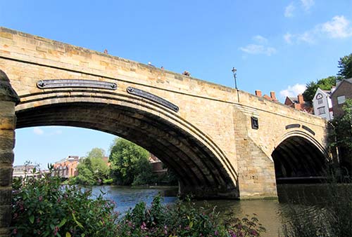
Framwellgate Bridge
This was a wonder when it was built in the 12th century—much longer than the river is wide and higher than seemingly necessary. It was designed to connect stretches of solid high ground and to avoid steep descents toward the marshy river. Note how elegantly today’s Silver Street (which leads toward town) slopes into Framwellgate Bridge. Until the 1970s, this people-friendly lane was congested with traffic and buses.
• Follow Silver Street up the hill to the town’s main square. This typical shopping drag is a mix of locals, students, and tourists; high-end and low-end; twee and practical. Cresting the top of the street, you pop out into...
Market Place
Entering this hub of activity, walk straight down the three steps and stand in the center of the square (surrounded by statues) to take it all in. For such an old city, much of the square has an architectural cohesiveness following extensive Victorian age renovations. Notice the statue of St. Nicholas over the door of pointy St. Nicholas Church. The patron saint not only of Christmas, but also of sailors, is holding not a sled but a ship. The sprawling building to the left is the Town Hall; through its facade are two entrances to a giant indoor market (described below). And, as if to emphasize that this square has been the thriving hub of local commerce for a millennium, three grand banks ring the top of Market Place. You might also spot friendly, pink-vested Durham Pointers, volunteers who love to answer tourists’ questions.
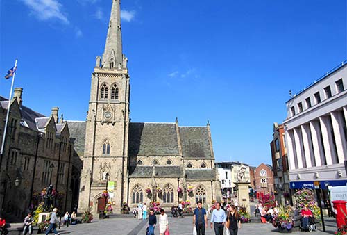
Notice how the square retains the same platting the prince-bishop gave it when he moved villagers here in about 1100 (see “Durham’s Early Years” sidebar, later). Each long and skinny plot of land was the same width (about eight yards), maximizing the number of shops that could have a piece of the Market Place action. Find today’s distinctly narrow buildings that still fit the 900-year-old plan. The widths of the other buildings fronting the square are multiples of that original shop width.
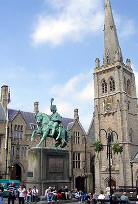
Examine the square’s statues. Coal has long been the basis of this region’s economy. The statue of Neptune (in front of Boots) was part of an ill-fated attempt by a coal baron to bribe the townsfolk into embracing a canal project that would make the shipment of his coal more efficient. At the top of the square, the fancy guy on the horse is Charles Stewart Vane, the third Marquess of Londonderry, an Irish aristocrat and a general in Wellington’s army who married a local coal heiress. And in front of the Town Hall stands a soldier from the Durham Light Infantry, a local regiment that fought fiercely for the Crown from 1881 until 1968 and remains a source of pride today.
Speaking of the Town Hall, notice the two corridors through its facade that are actually entrances to the city’s indoor market. In the 1850s throughout England, towns were moving their markets off squares and into Industrial Age iron-and-glass halls. Durham was no exception, and today its funky 19th-century market is a delight to explore (see listing earlier, under “Helpful Hints”). The space includes a sprawling hardware store along with a few shops, coffee stands, bakeries, and (up above, with free public WCs and great views down over the market interior) a handy café. There are also outdoor markets in the square, each Saturday and on the third Thursday of each month.
• Now we’ll go toward the cathedral. Head uphill, past the dandy Charles Stewart Vane, and angle left to take the street next to NatWest bank...
Saddler Street
Head up just a block or so, stopping where you reach the chunk of wall at the top of a stairway. On the left, you’ll see the 12th-century Elvet Bridge, which led to a town market over the river. Even today, the bridge leads to an unusually wide road—once swollen to accommodate market action. Shops lined one side of Elvet Bridge in the 12th century, as they do today. An alley separated the bridge from the buildings on the left. When the bridge was widened, it met the upper stories of the buildings on the left, which became “street level.”
Now look at the chunk of wall by the top of the stairs—a reminder of a once-formidable fortification. The Scots, living just 50 miles from here, were on the rampage in the 14th century. After their victory at Bannockburn in 1314, they pushed farther south and actually burned part of Durham. Wary of this new threat, Durham built thick city walls. As people settled within the walls, the population density soared. Soon, open lanes were covered by residences and became tunnels (called “vennels”). A classic vennel leads to Saddlers Yard, a fine little 16th-century courtyard (opposite the wall, look for the yellow Vennels Café sign). While the vennels are picturesque today, centuries ago they were Dickensian nightmares—the filthiest of hovels.
Continue up Saddler Street. Just before the fork at the top of the street, duck through the blue door next to the Georgian Window sign (on the right). You’ll see a bit of the medieval wall incorporated into the brickwork of a newer building and a turret from an earlier wall. Back on Saddler Street, you can see the ghost of the old wall (picture it standing exactly the width of the building now housing the Salvation Army).
• Veer right at Owengate as you continue uphill to...
Palace Green
This green was the site of the original 11th-century Saxon town, between the castle and an earlier church. Later, the town made way for 12th-century Durham’s defenses, which now enclose the green.
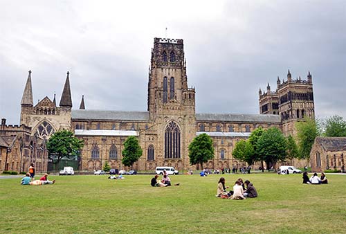
Glancing at your map of Durham, think for a moment just how strategic this site is: a long, narrow, steep promontory almost entirely encircled by a protective river (which flowed much more aggressively back then, before modern river-taming measures). Because the Norman kings appointed prince-bishops to rule this part of their realm, Durham was the seat of power for much of northern England—even nicknamed the “capital of the north.”
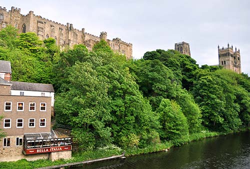
Head out into the middle of the green and get oriented. First, turn around to face the castle, which still stands—as it has for a thousand years—on its motte (man-made mound). But the castle is not just a castle; in 1832, it was donated to Durham University—England’s third oldest, after Oxford and Cambridge. Like those schools, Durham University is a collection of colleges scattered throughout the town—and this castle is the oldest (officially “University College,” though students mostly call it simply “The Castle.”)
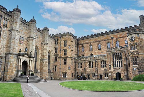
Now pan left, to see a long row of university buildings fronting Palace Green. In the middle, notice the doorway marked University Library. Through this door, the Durham World Heritage Site Visitor Centre has an information desk that sells tickets for those student-run tours; a shop with Durham U. swag; a small exhibit about the history of the castle, town, and university (volunteer guides love to explain the model of the promontory upon which Durham sits); a Museum of Archaeology that chronicles 10,000 years of human history on this spot; and a variety of temporary exhibits (all free except the castle tours; daily 10:00-17:00, +44 1913 342 932, durhamworldheritagesite.com).
Across the green from the library is another row of university buildings—a reminder that, aside from the towering cathedral, much of this hilltop is devoted to this prestigious institution, which has about 1,000 undergrads and 500 graduate students.
And of course, crowning the square (opposite the castle) is the towering Norman masterpiece, Durham Cathedral. With the cathedral at your back, find the lane between the castle and the library, marked by stone pillars and feeling like it should be crossing a moat (because it once was). Follow this to the gatehouse of the inner bailey of the castle—now a green and convivial “quad” of sorts for college students. You’re allowed to go only as far as the velvet ropes just inside the gatehouse, where you can get a good look at the courtyard. Architecturally, the castle is a hodgepodge; as successive bishops expanded the castle, they left their coats of arms as a way of “signing” the wing they built. Many of the windows you see facing the inner bailey are student residences; some 350 students in all live within the former castle. Standing here, seeing all those 21st-century students living among structures built by a millennium’s worth of prior Durhamites, you appreciate the depth and richness of this city’s history.
• If you’d like to go beyond those velvet ropes, sign up for a student-led tour inside the university library. When you’re ready, head back to Palace Green, cross it, and tour Durham’s stunning cathedral, described next.
Sights in Durham
DURHAM CATHEDRAL
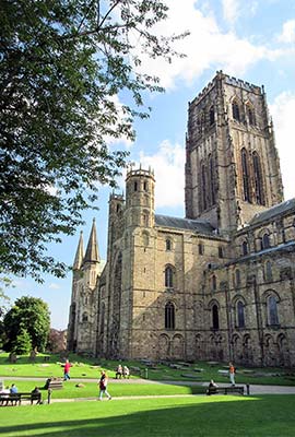
Built to house the much-venerated bones of St. Cuthbert from Lindisfarne, Durham Cathedral, worth ▲▲▲, offers the best look at Norman architecture in England. (“Norman” is British for “Romanesque.”) For a thousand years, this cradle of English Christianity has been praising God.
To really experience the cathedral, attend an evensong service. It’s a spiritual Oz, as the choristers (12 men and as many as 48 girls and boys) sing psalms—a red-and-white-robed pillow of praise, raised up by the powerful pipe organ.
Cost: Cathedral-free; tower climb-£10; cathedral museum-£7.50.
Hours: The cathedral is open to visitors Mon-Sat 10:00-16:00, Sun from 12:00, sometimes closes for special services, opens daily at 8:00 for worship and prayer. Access is limited for a few days in June, when the cathedral is used for graduation ceremonies (check online); +44 1913 387 178, durhamcathedral.co.uk.
Visitor Services: A shop, café, and WC are tucked away in the cloister. The café offers indoor seating as well as tables in the Monks’ Garden, under the twin towers overlooking the river.
Evensong: Arrive early and ask to be seated in the choir (Tue-Sat at 17:30, Sun at 15:30, 45 minutes; visiting choirs sometimes sing on Mon and nearly always fill in when cathedral choir is off on school break mid-July-Aug; +44 1913 387 178). For more on evensong, see here.
Organ Recitals: August through mid-September, noted organists play most Wednesday evenings (£12, 19:30, advance tickets available on the cathedral website under “Calendar”).
Tours: Regular tours run Monday through Saturday. If one is already in session, you’re welcome to join (£7.50; tours at 10:30, 11:30, 13:30, some summer tours also at 14:30; fewer in winter, call or check website to confirm schedule).
Tower Climb: The view from the tower will cost you 325 steps. Only 35 people can go up at the top of each hour—book online in advance in high season (Mon-Sat 10:00-15:00, sometimes open Sun outside of services; closed during services, events, and bad weather; must be at least 8 years old; enter through south transept).
Cathedral Museum: This fine collection of church artifacts—worth ▲—is eclipsed by its striking setting: the former monks’ quarters, including a stunning hall under heavy wooden beams (worth the price of admission; Mon-Sat 10:00-16:00, Sun 12:00-16:00).
 Self-Guided Tour
Begin your visit outside the cathedral. From the Palace Green, notice how this fortress of God stands boldly opposite the Norman keep of Durham’s fortress of man.
Look closely: The exterior of this awe-inspiring cathedral has a serious skin problem. In the 1770s, as the stone was crumbling, they crudely peeled it back a few inches. The scrape marks give the cathedral a bad complexion to this day. For proof of this odd “restoration,” study the masonry 10 yards to the right of the door. The L-shaped stones in the corner would normally never be found in a church like this—they only became L-shaped when the surface was cut back.
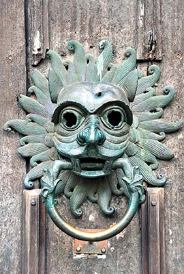
At the cathedral door, check out the big, bronze, lion-faced knocker (this is a replica of the 12th-century original, which is in the Cathedral Museum). The knocker was used by criminals seeking sanctuary.
As you enter, look immediately up to your right at the 1 modern window (Daily Bread) with its aerial view of the Last Supper. This window was given to the church by a local department store. The shapes of the apostles represent worlds and persons of every kind, from the shadowy Judas to the brightness of Jesus. This window is a good reminder that the cathedral remains a living part of the community.
Head to the back of the nave and enter the 2 Galilee Chapel (late Norman, from 1175). Find the smaller altar just to the left of the main altar. The paintings of St. Cuthbert and St. Oswald (seventh-century king of Northumbria) on the side walls of the niche are rare examples of Romanesque (Norman) paintings. Facing this altar, look above to your right to see more faint paintings on the upper walls above the columns. On the right side of the chapel, the upraised tomb topped with a black slab contains the remains of the Venerable Bede, an eighth-century Christian scholar who wrote the first history of England. We know this because the Latin reads, “In this tomb are the bones of the Venerable Bede.”
Exiting the chapel, you’ll pass the handy 3 information desk, which sells tickets for guided tours, the tower climb, and the museum.
Now head into the center of the church. Spanning the 4 nave, the black marble strip on the floor was as close to the altar as women were allowed in the days when this was a Benedictine church (until 1540). Sit down (ignoring the black line) and let the fine proportions of England’s best Norman nave—and arguably Europe’s best Romanesque nave—stir you. All the frilly woodwork and stonework were added in later centuries.
The architecture of the nave is particularly harmonious because it was built in a mere 40 years (1093-1133). The round arches and zigzag-carved decorations are textbook Norman. The church was also proto-Gothic, built by well-traveled French masons and architects who knew the latest innovations from Europe. Its stone and ribbed roof, pointed arches, and flying buttresses were revolutionary in England. Notice the clean lines and simplicity. It’s not as cluttered as other churches for several reasons: For centuries—out of respect for St. Cuthbert—no one else was buried here. During Reformation times, sumptuous Catholic decor was removed. Subsequent fires and wars destroyed what Protestants didn’t.
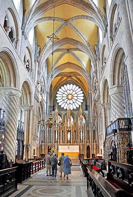
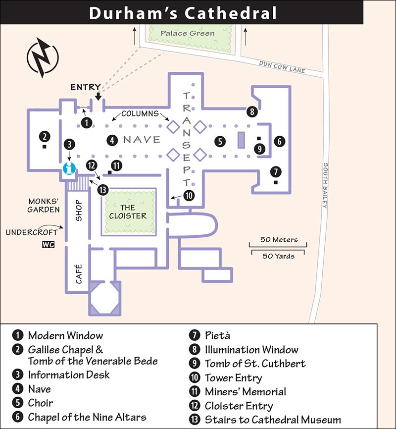
Stroll down the nave to the center, under the highest bell tower in Europe (218 feet). Gaze up. The ropes turn wheels upon which bells are mounted. If you’re stirred by the cheery ringing of church bells, tune in to the cathedral on Sunday (14:30-15:30) or every other Thursday (19:30-21:00 practice, trained bell ringers welcome, durhamringers.org), when the resounding notes tumble merrily through the entire town.
Continuing east (all medieval churches faced east), enter the 5 choir. Monks worshipped many times a day, and the choir in the center of the church provided a cozy place to gather in this vast, dark, and chilly building. Mass has been said daily here in the heart of the cathedral for 900 years. The fancy wooden benches are from the 17th century. Behind the altar is the delicately carved Neville Screen from 1380 (made of Normandy stone in London, shipped to Newcastle by sea, then brought here by wagon). Until the Reformation, the niches contained statues of 107 saints. Exit the choir from the far-right side (south). Look for the stained-glass Millennium Window (to your right) that commemorated the church’s 1,000th anniversary in 1995. The colorful scenes depict England’s history, from coal miners to cows to computers.
Step down behind the high altar into the east end of the church, which contains the 13th-century 6 Chapel of the Nine Altars. Built later than the rest of the church, this is Gothic—taller, lighter, and relatively more extravagant than the Norman nave—but look up to see if you can spot an error in the symmetry. On the right, see the powerful modern 7 pietà made of driftwood, with brass accents by local sculptor Fenwick Lawson.
Walk through the chapel to the north end, where you will find an 8 illumination window to your left. Designed by the glass artist Mel Howse, the window is a memorial to Sara Pilkington, a Durham University student who tragically died from a cardiac-related condition in 2012.
The window casts vibrant colors onto the 9 tomb of St. Cuthbert. Climb a few steps up to enter. An inspirational leader of the early Christian Church in north England, St. Cuthbert lived in the Lindisfarne monastery (100 miles north of Durham, today called Holy Island). He died in 687. Eleven years later, his body was exhumed and found to be miraculously preserved. This stoked the popularity of his shrine, and pilgrims came in growing numbers. When Vikings raided Lindisfarne in 875, the monks fled with his body (and the famous illuminated Lindisfarne Gospels, now in the British Library in London). In 995, after 120 years of roaming, the monks settled in Durham on an easy-to-defend tight bend in the River Wear. This cathedral was built over Cuthbert’s tomb.
Throughout the Middle Ages, a shrine stood here and was visited by countless pilgrims. In 1539, during the Reformation—whose proponents advocated focusing on God rather than saints—the shrine was destroyed. But pilgrims still come, especially on St. Cuthbert’s feast day (March 20).
Continue through the chapel and exit down the stairs. Walk down the south transept (to your left) to the 10 tower entry (tower described earlier), as well as an astronomical clock and the Chapel of the Durham Light Infantry, a regiment of the British Army (1881-1968). The old flags and banners hanging above were actually carried into battle. On the right-hand side over the black door, look for a banner for the Durham Miners Association, one of many miners associations that existed—and still exist—in Durham today.
Return along the left side of the nave toward the entrance. Across from the entry is the door to the cloister. Along the wall by the cloister door, notice the 11 memorial honoring coal miners who died, and those who “work in darkness and danger in those pits today.” (This message is a bit dated since Durham’s coal mines closed in the 1980s.)
Exit the church into the Gothic 12 cloister. Act like a monk and make a clockwise circuit of the cloister (made briefly famous in a scene from the film Harry Potter and the Sorcerer’s Stone in which Harry walks with his owl through a snowy courtyard). This area provides a fine view back up to the church towers.
The 13 cathedral museum entrance is just to the right of where you first entered the cloister. Even if you don’t have a ticket, head upstairs to ogle the stunning space and the fascinating Lego model—both viewable without paying admission.
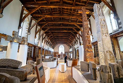
Cathedral Museum: The long, impressive Monks’ Dormitory stretches out under an original rustic-timber roof from 1404. Formerly the monks’ sleeping quarters, the room now holds striking artifacts.
Near the museum entrance, spend some quality time with the gigantic Lego model of Durham Cathedral. Made as a fundraiser for renovating this museum, this took several years and 300,000 Lego bricks, completed in 2016.
Stepping into the ticketed area, you’ll first see a variety of huge, stony artifacts: carved Roman stones, Celtic “preaching crosses,” and extremely rare “hogback” grave markers from Viking times. You’ll pass an evocative 2013 statue of St. Cuthbert, see a few more artifacts from the cathedral’s history, and—at the far end of the hall—find a door leading to the Collections Gallery. The double set of glass doors allows the cathedral to display more of its treasures in a climate-controlled environment. You’ll see an exhibit on the sanctuary knocker from the main door, then see the original by descending into the Great Kitchen, one of the best surviving medieval monastic kitchens in Britain. The kitchen also holds exhibits of many of the cathedral’s artifacts such as relics from St. Cuthbert’s tomb—his coffin, vestments, cross, and other personal effects. On occasion, you may also see a copy of the Magna Carta from 1216, as well as other items from the Norman/medieval period (when the monks of Durham busily copied manuscripts), the Reformation, and the 17th century.
Shortcut Back to Framwellgate Bridge: To return to the center of town in a few quick, downhill minutes, find the gap near the far-left end of the row of university buildings facing Palace Green (about 100 yards left of the University Library). Go down this narrow passage—nicknamed “Windy Gate”—then turn right on the footpath and head down the ramp. You’ll pop out next to the recommended Riverview Kitchen, a few steps below Framwellgate Bridge.
MORE SIGHTS IN DURHAM
▲▲Durham Castle/University Tours
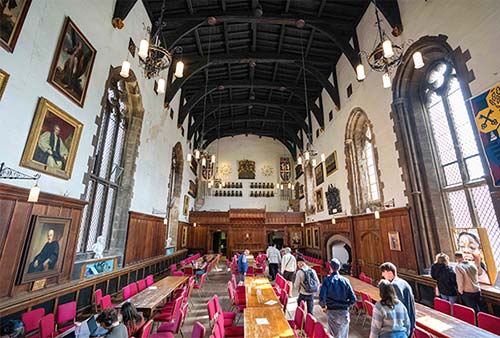
These wonderful, affordable, 45-minute, student-run tours are a sightseeing twofer: You hear gossipy “student life” stories, and also get inside Durham’s oldest building: the historic castle that today is one of the colleges of Durham University. You’ll begin by getting oriented in the courtyard, then head into the Norman Chapel (c. 1070s), carved from locally quarried sandstone and featuring delicate carvings at the tops of the columns. Then you’ll see the Tunstall Chapel (c. 1540s), a Gothic space with evocatively carved seats; the Tunstall Gallery, built to connect these old spaces, and lined with display cases of artifacts and a stunning Norman arch; the creaky (and supposedly haunted) Black Stairs, built by Prince-Bishop John Cosin; and finally, the Great Hall, a 13th-century, Harry Potter-style dining hall (with armor from Cromwell’s army and Napoleonic weapons displayed on the wall) still used to serve students three square meals a day.
Cost and Hours: £5; tours generally run several times each day when school is in session—but schedule varies, so call ahead or check online; prebook online or buy tickets at Durham World Heritage Site Visitor Centre in the University Library; +44 1913 342 932, durham.ac.uk/things-to-do.
Boat Cruise and Rental
Hop on the Prince Bishop for a relaxing one-hour narrated cruise of the river that nearly surrounds Durham (£12, April-Oct; for schedule, call +44 1913 869 525 or go down to the dock at Browns Boat House at Elvet Bridge, just east of the old town). Sailings vary based on weather and tides. For some exercise with the scenery, you can rent a rowboat at the same pier (£10/hour per person, £10 deposit required, mid-March-Sept daily 10:00-17:00, +44 1913 863 779).
Sleeping in Durham
During graduation (typically the last two weeks of June), everything is booked well in advance, and prices increase dramatically. Rooms can be tight on weekends any time of year. For locations of these places, see the “Durham” map, earlier.
BED-AND-BREAKFASTS
££ 40 Winks Hospitality feels professional and hotelesque, with nine rooms and generous public spaces filling a house that’s a five-minute, gently uphill walk from Framwellgate Bridge (with fine cathedral views on the way up). The back-facing rooms are comfortable and affordable; “premium” rooms facing the street are bigger, have bathtubs, and can get quite expensive (40 South Street, +44 191 380 3000, 40winkshospitality.co.uk, info@40winkshospitality.co.uk, George).
££ Castle View Guest House rents five airy, restful rooms in a well-located, nearly 300-year-old guesthouse next door to a little church. If it’s sunny, guests relax in the Eden-like backyard. Located on a charming cobbled street, it’s just above Silver Street and Framwellgate Bridge—take the stairs just after the church (free street-parking permit, 4 Crossgate, +44 1913 868 852, castle-view.co.uk, info@castle-view.co.uk, Anne).
££ The Georgian Town House B&B, just a few doors up from Castle View Guest House, is beautifully decorated. Friendly owners Jane and Robert rent two en suite rooms in their own home (sometimes a third family room is available—ask). Their daughter Lucy runs the popular pancake restaurant downstairs (which also serves breakfast for guests) in a cozy space that used to be their garage (minimum 2-night stay on weekends, +44 739 987 4997, thegeorgiantownhousedurham.co.uk, thegeorgiantownhouse@yahoo.com).
££ Farnley Tower, in a restored 19th-century mansion with wildly colorful decor, has 17 large rooms. On a quiet street at the top of a hill, it’s a 15-minute hike up from the town center. Because of its size, you won’t get the same personal touch, but it’s a solid option if you don’t mind some walking (some rooms with cathedral views, family room, easy free parking, inviting yard, The Avenue—hike up this steep street and look for the sign on the right, +44 1913 750 011, farnley-tower.co.uk, enquiries@farnley-tower.co.uk, Raj and Roopal Naik and hardworking Anna). The Naiks also run the inventive Indian restaurant in the same building.
HOTELS
When the B&Bs are full, resort to a hotel, even a bigger chain hotel, such as the Marriott (listed below) or the centrally located Premier Inn (on Freeman’s Place).
£££ Kingslodge Inn & Restaurant is a comfortable 23-room place with charming outdoor spaces, an attached restaurant and pub, and a handy location. Situated in a pleasantly wooded setting, it’s convenient for train travelers (family rooms, free parking, Waddington Street, Flass Vale, +44 1913 709 977, inncollectiongroup.com/kingslodge-inn, enquiries@kingslodgeinn.co.uk).
£££ Delta Hotel Durham Royal County, part of the Marriott hotel chain, scatters its 150 business-class but slightly scruffy rooms among several buildings sprawling across the river from the city center (breakfast extra, fitness room, elevator, restaurant, terrace bar, pay parking, Old Elvet, +44 1913 866 821, marriott.co.uk).
STUDENT HOUSING OPEN TO ANYONE
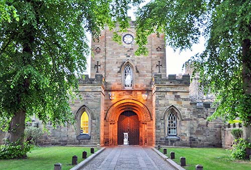
£ Durham Castle, a student residence on the castle grounds facing the cathedral, rents rooms during the summer break (generally July-Sept). The options—including some in historic spaces within the castle—are well described on their website; rates include breakfast in a grand dining hall (Palace Green, +44 800 289 970, durham.ac.uk—search “Bed and Breakfast,” event@durham.ac.uk). Note that the same office also rents rooms in other university buildings, but most are far less convenient to the city center—make sure to request the Durham Castle location when booking.
Eating in Durham
For locations of these places, see the “Durham” map, earlier.
IN THE TOWN CENTER
In this college town, the main thoroughfares abound with a dizzying variety of cheap, easy, tasty, international fare. For a more serious meal, consider these options.
££££ Coarse is the place for a central splurge. It’s tucked down a gritty courtyard just off bustling North Street; but inside it feels classy, understated, and food-focused, with a well-curated menu of local and international dishes created by an acclaimed chef (fixed-price meals only—figure £30 at lunch or £50 at dinner; open Wed for dinner only, Thu-Sat for lunch and dinner, closed Sun-Tue, Reform Place off North Road, +44 191 380 5776, coarse.restaurant).
££ Isla, just up the street (near the base of the bridge to the train station), is Coarse’s casual bistro, with a tight and trendy interior and a short, tempting menu of international “sharing plates.” In addition to lunch and dinner, it’s a popular spot for brunch (Tue-Sun brunch, Tue-Wed also lunch, Thu-Sat also dinner, closed Mon, 53 North Road, +44 191 384 3378, islabycoarse.restaurant).
££ Riverview Kitchen, just below the Framwellgate Bridge on the cathedral side (follow signs down from the bridge), has a friendly staff and tables overlooking the river and bridge, and a crowd-pleasing menu of burgers, sandwiches, pancakes, salads, cakes, and more (daily until 18:00, 21 Silver Street, +44 1913 845 777, facebook.com/riverviewkitchendurham).
£ Bells is a standby for carryout fish-and-chips just off Market Place toward the cathedral. I’d skip their fancier dining room (daily, lunch only on Sun, 11 Market Place, +44 1913 848 974, bellsfishshop.co.uk).
££ La Spaghettata serves decent Italian food in a lively, festive setting. The hardworking staff serves pasta, pizza, and daily specials to hungry locals and tourists—but I’d come for the atmosphere more than the cuisine (daily for dinner, Fri-Sun also open for lunch, 66 Saddler Street, +44 1913 839 290, fabiosdurham.com).
JUST BEYOND THE CENTER
These places are a 5-to-10-minute walk from the old core of Durham.
£ Claypath Delicatessen is worth a few minutes’ walk above Market Place for lunch. Not just any old deli, this place assembles fresh ingredients and homemade sourdough bread into tasty sandwiches, salads, flatbreads, and more. They pride themselves on their killer espresso. While carryout is possible, most people eat in the casual, comfortable café setting or out back on the terrace, next to a lovely community garden. They’re also open Friday nights for “pizza night” (Tue-Sat until 16:00, closed Sun-Mon; from Market Place, cross the bridge and walk up Claypath to #57; +44 1913 407 209, claypathdurham.com).
££ Whitechurch, a bit of a walk out of the town center, is versatile—it’s great for coffee and a pastry, a pint on their back patio, or a tasty and creative lunch. The decor feels posh-pub chic and the atmosphere is relaxed (daily until 18:00; 29 Church Street Head—from the Elvet Bridge, turn right on New Elvet, then bear right on Church Street Head; +44 1913 868 897, whitechurchdurham.com).
Classic Pub: £ The Dun Cow is popular with locals and good for beer and ales. There’s a cozy “snug bar” up front and a more spacious lounge in the back. Read the legend behind the pub’s name on the wall along the outside corridor. More sedate than the student-oriented places in the town center, this pub serves only snacks—come here to drink and nibble, not to feast (daily; from the Elvet Bridge, walk five minutes straight ahead to Old Elvet 37; +44 1913 869 219).
Supermarket: Look for Tesco Express in the old town, just off Market Place (daily). You can picnic on Market Place, or on the benches and grass outside the cathedral entrance (but not on the Palace Green, unless the park police have gone home).
Durham Connections
From Durham by Train to: York (4/hour, 1 hour), Keswick/Lake District (train to Penrith—hourly, 3 hours, 1-2 transfers, then bus to Keswick), London (hourly direct, 3 hours, more with transfers), Hadrian’s Wall (take train to Newcastle—4/hour, 20 minutes, then a train/bus or train/taxi combination to Hadrian’s Wall—see “Getting Around Hadrian’s Wall,” later in this chapter), Edinburgh (hourly direct, 2 hours, more with changes, less frequent in winter). Train info: +44 3457 484 950, nationalrail.co.uk.
ROUTE TIPS FOR DRIVERS
As you head north from Durham on the A-1 motorway (beyond the junction for Beamish Museum, described next), you’ll pass a famous bit of public art: the Angel of the North, a modern, rusted-metal angel standing 65 feet tall with a wingspan of 175 feet (wider than a Boeing 757). While initially controversial when it was erected in 1998, it has since become synonymous with Northeast England and is a beloved local fixture.
Beamish Museum
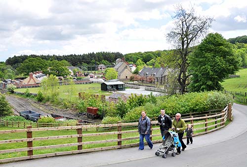
This huge, 300-acre open-air museum, which re-creates life in northeast England during the 19th and 20th centuries, is England’s best museum of its type. To truly appreciate it, you should set aside three to four hours to explore its five sections: Pit Village (a coal-mining settlement with an actual mine), 1900s Town (an early 20th-century street lined with actual shops), Pockerley Old Hall (the manor house of a “gentleman farmer”), 1940s Farm (a preserved farm and farmhouse), and the newest section, 1950s Town (still under development). The attendants who happily explain everything at each stop make your visit worth ▲▲▲.
GETTING THERE
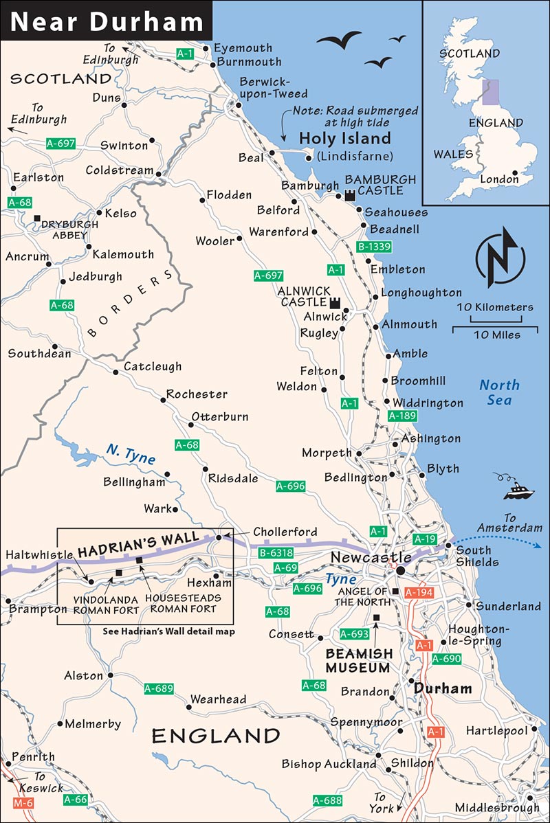
By car, the museum is five minutes off the A-1/M-1 motorway (one exit north of Durham at Chester-le-Street/Junction 63, well signposted; it’s a 12-mile, 25-minute drive northwest of Durham). You’ll find free parking in the hills leading down to the main entrance.
Getting to Beamish from Durham by bus is an uncomplicated affair. Catch bus #X12, #21, #X21, or #50 from the Durham bus station (3-4/hour, 25 minutes) and transfer at Chester-le-Street to bus #8 or #28, which take you right to the museum entrance (2/hour Mon-Sat, hourly Sun, 15 minutes, leaves from South Burns Stand L at the central bus kiosk, +44 1914 205 050, traveline.info). Show your bus ticket for a museum discount.
ORIENTATION TO BEAMISH MUSEUM
- Cost and Hours: £27.95; £17.25 for kids 5-16, free for kids 4 and under; daily 10:00-17:00; March Wed-Sun until 16:00, closed Mon-Tue; closed Nov-Feb, last entry one hour before closing, +44 1913 704 000, beamish.org.uk.
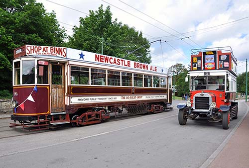
- Getting Around the Museum: Pick up a free map at the entry to help navigate the five zones; while some are side by side, others are up to a 15-minute walk apart. Vintage trams and cool, circa-1910 double-decker buses shuttle visitors around the grounds, and their attendants are helpful and knowledgeable. Signs on the trams advertise a variety of 19th-century products, from “Borax, for washing everything” to “Murton’s Reliable Travelling Trunks.”
- Eating: Several eateries are scattered around Beamish, including a pub and tearooms (in 1900s Town), two fish-and-chips stands (in the Pit Village and the 1950s terrace), and various cafeterias and snack stands. Or bring a picnic.
VISITING THE MUSEUM
I’ve described the five areas in counterclockwise order from the entrance.
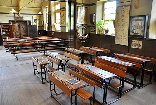
From the entrance building, bear left along the road, then watch for the turnoff on the right to the Pit Village & Colliery. This is a company town built around a coal mine, with a schoolhouse, a Methodist chapel, and a row of miners’ homes with long, skinny pea-patch gardens out front. Poke into some of the homes to see their modest interiors. In the school, explore the classrooms and look for the interesting poster with instructions for avoiding consumption (aka tuberculosis, a huge public-health crisis back then).
Next, cross to the adjacent colliery (coal mine), where you can take a fascinating 20-minute tour into the drift mine (may be claustrophobic for some, but it doesn’t go far—if you don’t like it, you can turn back; check in at the “lamp cabin”—tours depart when enough people gather, generally every 5-10 minutes). Your guide will tell you stories about beams collapsing, gas exploding, and flooding; after that cheerful speech, you’ll don a hard hat as you’re led into the mine.
Notice in the lamp cabin how each lamp has a number. Miners arriving for work would yell out their number and be given a lamp and two tokens—one brass, one zinc—with that number. A “bankman” would collect each miner’s zinc token as he entered the mine, returning it to the number board in the lamp cabin. When the miner exited at the end of the day, he would hang his brass token over the zinc one, signifying he’d safely left the mine. You’ll also see a sign discouraging spitting. Miners would salivate a lot, primarily because of tuberculosis, but also from chewing tobacco.
Nearby (across the tram tracks) is the fascinating mine elevator, where you can see the actual steam-powered winding engine used to operate it. A “winderman” may be there to demonstrate how he skillfully eases both coal and miners up and down the tight mine shaft. This delicate, high-stakes job was one of the most sought-after at the entire colliery—passed down from father to son—and the winderman had to stay in this building for his entire shift (the seat of his chair flips up to reveal a built-in WC).
A path leads through the woods to Georgian-era Pockerley, which has two parts. First you’ll see the Waggonway, a big barn filled with steam engines, including the re-created, first-ever passenger train from 1825. (Occasionally this train takes modern-day visitors for a spin on 1825 tracks—a hit with railway buffs.)
Then, walk back and climb the hill to Pockerley Old Hall, the manor house of a gentleman farmer and his family. The house dates from the 1820s, and—along with the farmhouse described later—is Beamish’s only vintage building still on its original site (other buildings at Beamish were relocated from elsewhere and reconstructed here). While not extremely wealthy, the farmer who lived here owned large tracts of land and could afford to hire help to farm it for him. This rustic home is no palace, but it was comfortable for the period. Costumed docents in the kitchen sometimes bake delicious cookies from old recipes...and hand out samples.
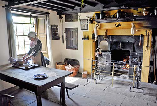
The small garden terrace out front provides beautiful views across the pastures. From the garden, turn left and locate the narrow stairs up to the “old house.” Actually under the same roof as the gentleman farmer’s home, this space consists of a few small rooms that were rented by some of the higher-up workers to shelter their entire families of up to 15 children (young boys worked on the farm, while girls were married off early). While the parents had their own bedroom, the children all slept in the loft up above (notice the ladder in the hall).
From the manor house, hop on a vintage tram or bus or walk 10 minutes to 1950s Town (parts of which may still be under construction), where the buildings include a replica of a local welfare hall and community center (there’s also a playground and minigolf course). Visit the clinic tucked in the back where you may find a midwife, who would offer advice to new parents and do pediatric check-ups. Next, move into the assembly hall to experience card games, dances, and crafts. Farther on, you’ll see several midcentury businesses, including a hair salon, ice cream parlor, toy store, cinema, and fish-and-chips shop—all of which are fully operational.
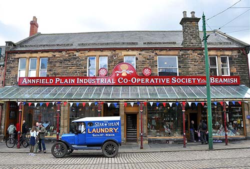
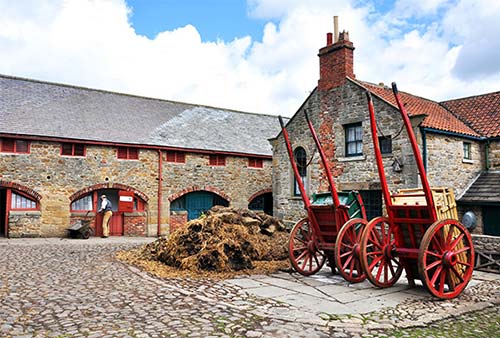
From here, a short walk takes you back to the Edwardian era in 1900s Town (c. 1913). This bustling street features several working shops and other buildings that are a delight to explore. In the Masonic Hall at the beginning of the town, ogle the grand high-ceilinged meeting room. Farther on, check out the fun, old metal signs inside the garage. Across the street, poke into the courtyard to find the stables, which are full of carriages (and sometimes horses). The heavenly-smelling candy store sells old-timey sweets and has a workshop in back with trays of free samples. The newsagent sells stationery, cards, and old toys, while in the grocery, you can see old packaging and the scales used for weighing out products. Other buildings include a clothing store, a working pub (The Sun Inn; don’t expect 1913 prices), Barclays Bank, and a hardware store featuring a variety of “toilet sets” (not what you think).
For lunch, try the Tea Rooms cafeteria (upstairs); or, if the weather is good, picnic in the grassy park with the gazebo next to the tram stop. The row of townhouses includes both homes and offices (if the dentist is in, chat with him to hear some harrowing stories about pre-Novocaine tooth extraction). At the circa-1913 railway station at the far end of 1900s Town, you can stand on the bridge over the tracks to watch old steam engines go back and forth—along with a carousel of “steam gallopers.”
Finally, walk or ride a tram or bus to 1940s Farm. (This is the least interesting section—if you’re running short on time, it’s skippable.) Here you’ll get to experience a petting zoo and see a “horse gin” (aka “gin gan”)—where a horse walking in a circle turned a crank on a gear to amplify its “horsepower,” helping to replace human hand labor. Near the cafeteria, you can cross a busy road to the old farmhouse, still on its original site, where attendants sometimes bake goodies on a coal fire.
Hadrian’s Wall
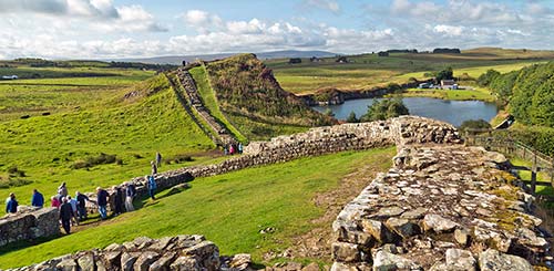
Cutting across the width of the isle of Britain, this ruined Roman wall is one of England’s most thought-provoking sights. Once a towering 20-foot-tall fortification, these days “Hadrian’s Shelf,” as some cynics call it, is only about three feet wide and three to six feet high. (The conveniently precut stones of the wall were carried away by peasants during the post-Rome Middle Ages and now form the foundations of many local churches, farmhouses, and other structures.) In most places, what’s left of the wall has been covered over by centuries of sod, making it effectively disappear into the landscape. But for those intrigued by Roman history, Hadrian’s Wall provides a fine excuse to take your imagination for a stroll. These are the most impressive Roman ruins in Britain. Pretend you’re a legionnaire on patrol in dangerous and distant Britannia, at the empire’s northernmost frontier...with nothing but this wall protecting you from the terrifying, bloodthirsty Picts just to the north.
Today, several restored chunks of the wall, ruined forts, and museums thrill history buffs. While a dozen Roman sights cling along the wall’s 73-mile route, I’ve focused my coverage on an easily digestible six-mile stretch right in the middle, where you’ll find the best museums and some of the most enjoyable-to-hike stretches.
A breeze for drivers, this area can also be seen in summer by bus for those good at studying timetables (see “Getting Around Hadrian’s Wall,” later).
PLANNING YOUR TIME
Hadrian’s Wall is in vogue as a destination for multiday hikes through the pastoral English countryside. The Hadrian’s Wall National Trail runs 84 miles, following the wall’s route from coast to coast (for details, go to nationaltrail.co.uk/hadrianswall). Through-hikers (mostly British) walk the wall’s entire length in 4-10 days. You’ll see them bobbing along the ridgeline, drying out their socks in your B&B’s mudroom, and recharging at local pubs in the evening. For those with less time, the brief ridge walk next to the wall from Steel Rigg to Sycamore Gap gives you an ideal taste of the scenery and history.
You can also experience Hadrian’s Wall by visiting any of three sights: Housesteads Roman Fort, with its ruined foundations and modest museum up next to the wall; Vindolanda, an even bigger fort and better museum set down in the valley below (far from the wall); and the Roman Army Museum, an indoors look at the history behind the wall. All except the Roman Army Museum require a fair bit of uphill walking.
If you’re being selective, here are some considerations: In good weather, those who are in decent shape will enjoy walking along the wall. If you have time for only one stop, Housesteads is a convenient combination: fortress ruins, a quick look at the wall itself, and a small museum. Vindolanda’s fort and museum are both better than Housesteads, and it requires somewhat less walking. The Roman Army Museum, next to the Walltown Visitor Centre, is the best bad-weather option.
Orientation to Hadrian’s Wall
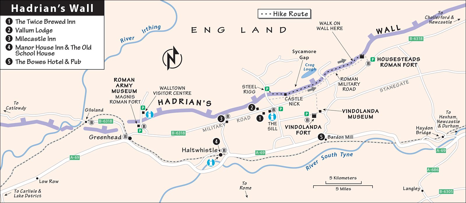
The area described in this section is roughly between the midsize towns of Bardon Mill and Haltwhistle, which are located along the busy A-69 highway. Each town has a train station and some handy B&Bs, restaurants, and services. However, to get right up close to the wall, you’ll head a couple of miles north to the adjacent settlements of Once Brewed and Twice Brewed, an area collectively called “The Sill” (along the B-6318 road).
If you want to walk the wall, Hadrian’s Haul can send your luggage ahead to your next B&B in the area (+44 7799 828 282, hadriansbags.co.uk).
TOURIST INFORMATION
For an overview of your options, visit the helpful website at hadrianswallcountry.co.uk. All the offices listed below happily offer hiking advice and hand out free maps, or can sell you a better one. All of them are also near stops for the Hadrian’s Wall bus #AD122 route, and have pay parking lots.
The handiest outlet for visitor information is The Sill National Landscape Discovery Centre, along road B-6318 (next to Twice Brewed Inn and about a half-mile below the Steel Rigg trailhead). This slick modern facility with a grassland roof features interactive exhibits about the surrounding landscape—including a large chunk from the tree that once filled Sycamore Gap. The complex also includes an 86-bed hostel, a local crafts shop, and the Once Brewed Café, selling affordable lunches (daily 10:00-17:00, Nov-March until 16:00, +44 1434 341 200, thesill.org.uk).
The Walltown Visitor Centre, at the Walltown County Park just up the road from the Roman Army Museum, is another helpful information outlet (daily 10:00-17:00, closed Oct-March, just off the B-6318 near the Roman Army Museum, follow signs to Walltown Country Park, +44 1697 747 121, northumberlandnationalpark.org.uk). The surrounding park has WCs, well-groomed nature walks, and an access point for Hadrian’s Wall.
The TI in Haltwhistle, a block up from the train station inside the library, is also helpful (Mon-Fri 10:00-13:00 & 13:30-16:30, Sat 10:00-13:00, closed Sun, Westgate, +44 1434 321 863, visithaltwhistle.com).
GETTING AROUND HADRIAN’S WALL
Hadrian’s Wall is anchored by the big cities of Newcastle to the east and Carlisle to the west. Driving is the most convenient way to see Hadrian’s Wall. If you’re coming by train, consider renting a car for the day at either Newcastle or Carlisle; otherwise, you’ll need to rely on trains and a bus to connect the sights, hire taxis, or book a private guide with a car. If you’re just passing through for the day using public transportation, it’s challenging to stop and see more than just one or two of the sights—study the schedules carefully and prioritize. Nondrivers who want to see everything—or even hike part of the wall—will need to stay one or two nights along the bus route.
By Car
Zip to this “best of Hadrian’s Wall” zone on the speedy A-69; when you get close, head a few miles north and follow the B-6318, which parallels the wall and passes several viewpoints, minor sights, and “severe dips.” (These road signs add a lot to a photo portrait.) Buy a good local map to help you explore this interesting area more easily and thoroughly. You’ll pay, pay, pay for parking; just about every stop mentioned here (except for Vindolanda and the Roman Army Museum) has its own pay parking.
Without a Car
By Bus: To reach the Roman sights without a car, take the made-for-tourists Hadrian’s Wall bus #AD122 (named for the year the wall was built). This bus connects the Roman sights (and several recommended accommodations) with train stations in Haltwhistle and Hexham (£2.50/ride—buy on board, or £6 unlimited Northumberland Day Rover ticket—buy online; 5/day, check up-to-date schedules online at gonortheast.co.uk/ad122). If you’re coming from Carlisle or Newcastle, you’ll need to take the train to Haltwhistle or Hexham and pick up the bus there. To encourage public transportation use, most sights in the area offer a small discount if you show them a bus ticket—ask.
By Train: The Tyne Valley Railway runs parallel to and a few miles south of the wall much more frequently than the bus. While the train stops at stations in larger towns—including (west to east) Carlisle, Haltwhistle, Hexham, and Newcastle—it doesn’t take you near the actual Roman sights. To reach them, you can catch bus #AD122 (described above) at Hexham or Haltwhistle (train runs hourly; Carlisle to Haltwhistle—30 minutes, Haltwhistle to Hexham—20 minutes, Hexham to Newcastle—40 minutes; northernrail.org).
By Taxi: These Haltwhistle-based taxi companies can help you connect the dots: Sproul (+44 7712 321 064) or Diamond (+44 7597 641 222). Figure about £15 one-way from Haltwhistle to Housesteads Roman Fort (arrange for return pickup or have museum staff call a taxi). Note that on school days, taxis are busy shuttling rural kids to and from class in the morning (about 8:00-10:00) and afternoon (about 14:30-16:30), so you may have to wait.
By Private Tour: Peter Carney, a former history teacher who waxes eloquent on all things Roman, offers tours with his car to the area’s major sights, plus guidance for hiking the wall on your own (£300/day for up to 4 people, £175/half-day, does not include museum admissions; he can pick you up at the Haltwhistle or Hexham stations for no extra charge, or in Newcastle for £125 extra; +44 7585 139 016, hadrianswall-walk.com, petercarney@hadrianswall-walk.com).
Sights at Hadrian’s Wall
▲▲Hiking the Wall
Hiking along the wall speaking Latin—even if only for a little while—is enough to give historians goosebumps, and on a nice day, enjoyable for anyone. Note that park rangers forbid anyone from walking on top of the wall, except along a very short stretch at Housesteads. On the following hike, you’ll walk alongside the wall.
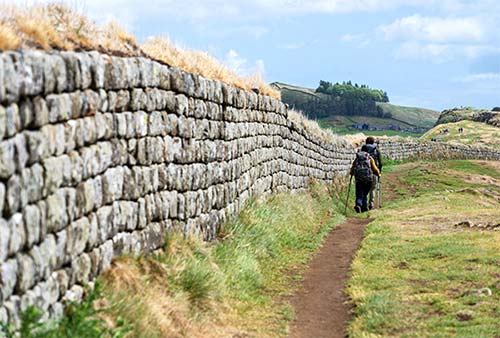
The best craggy, scenic, up-and-down stretch of wall to follow is between the parking lot at Steel Rigg and Sycamore Gap (the round-trip takes about an hour, maybe less); with more time and energy you could continue all the way to Housesteads Roman Fort, or take another variation (outlined later).
The Sill and Walltown visitors centers hand out a free description of this walk; ask their advice for the various lengths and return options. Even the shortest version of this hike is moderately strenuous—with lots of steep stretches up and down, on uneven and irregularly placed stone steps—and is best for those in decent shape. You’ll need sturdy shoes and a windbreaker to comfortably overcome the often-blustery environment. As you would while driving in Britain, stay on the left side of the path when you meet other hikers.
Steel Rigg to Sycamore Gap: Begin at the pay parking lot at Steel Rigg. Take the little road off the B-6318 near The Sill and park in the lot on the right at the crest of the hill. (You could also park at the Sill’s lot, and hike up to Steel Rigg from there.)
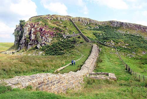
From the parking lot, step through the gate and head downhill to reach the shoulder-high stretch of wall, turn left, and follow the wall running steeply down the valley below you. Ahead of you are dramatic cliffs, creating a natural boundary made to order for this Roman fortification. Walk down the steep slope into the valley, then back up the other side (watch your footing on the stone stairs—the path up is the steepest stretch on this walk).
In the third gap is one of the best-preserved milecastles, #39 (called Castle Nick because it sits in a nick in a crag). Each milecastle controlled a gate, and the gates meant income since the Roman Empire would take a cut every time goods passed through them. That may explain why Hadrian wanted so many gates, even when there were rugged hills and cliffs in the way.
Soon after Castle Nick, you’ll reach the fourth gap, called Sycamore Gap for the large symmetrical tree that once stood there. The tree, more than 200 years old, was much loved by locals and visitors alike—an icon for all of Hadrian’s Wall. Sadly, vandals cut it down in 2023, leaving it resting on the ancient wall. Today, its bulky trunk is fenced off and saplings have appeared, leading many locals to hope it will grow again.
Roaming Back: At Sycamore Gap, you can head back the way you came, up and down along those four gaps. For a somewhat easier return, you can walk down a short stretch toward the main road to find a less strenuous path, which skirts lower down on the ridge (rather than following the wall up and down). The lower path leads back to the base of the Steel Rigg hill (at Peel Cottage), where you can huff back up to your car.
Extending the Hike: For a longer hike, you can carry on along the wall to Housesteads Roman Fort. You’ll pass a traditional Northumbrian sheep farm and more ups and downs. Soon after Sycamor Gap is Crag Lough—a windswept and lonesome lake. As you close in on Housesteads, you’ll be able to actually walk on top of the wall. Keep in mind that this is three miles one-way; you’ll either need to return by foot, or time your hike to catch bus #AD122 from Housesteads back to The Sill, then hike back up to Steel Rigg for your car.
Meandering Options: There are also other variations, of shorter and longer lengths. For a shorter loop than the full Housesteads trek, curl down to the left at Milecastle 38 (after Crag Lough), then follow a trail along the north side of the wall back to Steel Rigg (figure about 4 miles/2 hours round-trip). Or, for a more ambitious, all-day ramble, hike all the way (or nearly all the way) to Housesteads, cut down to Vindolanda, then make your way all the way back to your car (plan on 7 miles/4 hours of walking, plus sightseeing stops). Before tackling these ambitious hikes, pick up a map with clear turn-by-turn instructions at a TI.
▲▲Housesteads Roman Fort
With its small but respectable museum, powerful scenery, and the best-preserved segment of the wall, this is perhaps the single most convenient one-stop look at Hadrian’s Wall. It requires a steep hike up from the parking lot...but once there, it’s just you, the bleating sheep, and memories of ancient Rome.
Cost and Hours: £16 includes site and museum, generally daily 10:00-17:00, Nov-March until 16:00—confirm before making the trip, last entry 45 minutes before closing, pay parking, bus #AD122 stops here; +44 1434 344 363, english-heritage.org.uk/housesteads.
Visitor Services: The parking lot has a visitors center with WCs and a basic café; the museum, at the top of the hill, sells only snacks.
Visiting the Museum and Fort: From the parking lot, you’ll hike about a half-mile uphill to the fort, on a well-tended gravel path. At the top of the hill, head left to the museum before touring the site. As you enter, look for the giant Victory statue, which once adorned the fort’s East Gate; her foot is stepping on a globe, serving as an intimidating reminder to outsiders of the Romans’ success in battle. A good seven-minute film shows how Housesteads (known back then as Vercovicium) would have operated, and a model of the site brings meaning to the ruins you’re about to visit. Scant fragments of a cooking pot from Frisia (Northern Holland) indicate the presence of women, showing that the (mostly northern European) soldiers came with their families in tow. A tweezer, probe, spoons, and votive foot (that would have been offered to the gods in exchange for a cure for a foot ailment) reveal the type of medical care you could expect.
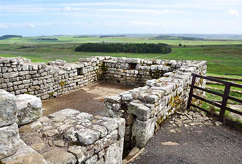
After exploring the museum, head out to the sprawling ruins of the fort. You’ll enter through the south gate, and head slowly uphill through the middle of the complex. All Roman forts were the same rectangular shape and design. In the center was the headquarters (principia), with the commander’s office, a hospital, granary, and a bakery where the soldiers would make bread and cook meals. Rows of barracks—which housed up to 800 soldiers—stretched in either direction; near the top of the complex, on the right, you’ll find foundations that make these barracks especially easy to imagine. Housesteads also has the best-preserved Roman latrines found anywhere—look for them at the lower-right corner, smartly downwind. Cresting the top of the hill, you reach the wall itself, at the heavily defended north gate. Even if you’re not a hiker, take some time to walk the wall here. (This is the one place along the wall where you’re allowed to get up and walk on top of it for a photo op.)
▲▲Vindolanda Fort and Museum
This large Roman fort (which predates the wall by 40 years) sits just south of the wall. While the ruins—still being excavated—are roughly on par from a sightseeing perspective with Housesteads (only bigger), Vindolanda’s museum is by far the best in the area, packed with artifacts that reveal intimate details of Roman life.
Getting There: Vindolanda has two entrances, east and west; for the easiest access, use the west main entrance. To get there, follow the signs to Vindolanda from A-69 or B-6318 (near The Sill). (If you see a steep hill from the parking lot, you are at the east entrance.)
Cost and Hours: £15, £20 combo-ticket includes Roman Army Museum, daily 9:30-17:30, last entry one hour before closing, free parking, bus #AD122 stops here, café at museum, +44 1434 344 277, vindolanda.com [URL inactive].
Tours: Free guided tours are offered April through October (daily at 11:00 and 13:00, additional tours on Sat-Sun and in summer at 10:00 and 12:00; call or check website to confirm).
Archaeological Dig: The Vindolanda site is an active dig—from Easter through mid-July, then again in September, you’ll see the excavation work in progress (usually Mon-Fri, weather permitting). Much of the work is done by volunteers, including armchair archaeologists from the US.
Visiting the Site and Museum: After buying your ticket and passing through the entrance building, look for the aerial photograph of the entire site as it was in Roman times. Notice that the site had two parts: the fort itself, and the vicus (town) just outside that helped to supply it.
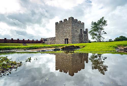
Head out to the site, walking through 500 yards of grassy parkland, first passing the foundations of the village, which had a bathhouse, a tavern, shops, and residences; then following the large flagstones through what was the main gate of the fortress. The foundation stones of this fort have many of the same features as Housesteads: a central headquarters (principia) surrounded by barracks. Far off on the right is a full-size replica stretch of Hadrian’s Wall. Over the course of 400 years, at least nine forts were built on this spot. (Most of what you see dates from the third and fourth centuries.) The Romans, by lazily sealing the foundations from each successive fort, left modern-day archaeologists with a 20-foot-deep treasure trove of remarkably well-preserved artifacts: keys, coins, brooches, scales, pottery, glass, tools, leather shoes, bits of cloth, and even a wig. Many of these are now displayed in the museum.
At the far end of the site, you’ll go down a short, steep hill and pass through the pleasant riverside garden area on the way to the well-presented museum. Each artifact is accompanied by insightful explanations—such as a collection of Roman shoes with a description about what each one tells us about its wearer (including women and children). The weapons (including arrowheads and spearheads) and fragments of armor are a reminder that Vindolanda was an important outpost on Rome’s northern boundary—look for the Scottish skull that was likely stuck on a pike to discourage rebellion.
Thanks to Vindolanda’s boggy grounds, trash tossed away by the Romans was preserved in an airless environment. You’ll see the world’s largest collection of Roman leather (including boxing gloves); tools that were used for building, repairing, and expanding the fort; locks and keys (the fort had a password that changed daily—jotting it on a Post-It note wasn’t allowed); a large coin collection; items imported here from the far corners of the vast empire (such as fragments of French pottery and amphora jugs from the Mediterranean); exquisite jewelry; beauty aids such as combs, tools for applying makeup, and hairpins; and religious pillars and steles.
But the museum’s main attraction is its collection of writing tablets. A good video explains how these impressively well-preserved examples of early Roman cursive were discovered here in 1973. In the darkened room, you can squint at some of the actual letters—written on thin pieces of wood—alongside the translations. These letters bring Romans to life in a way that ruins alone can’t. The most famous piece (described but not displayed here) is the first known example of a woman writing to a woman (an invitation to a birthday party). A large interactive screen lets you choose and read tablets selected by Robin Birley, a British archaeologist and former leader of the excavations.
Outside the museum, explore the pleasant garden area. You’ll find a fully functional replica of a Roman pottery kiln, a kids’ pavilion showing how children lived in Roman times (with an activity center next door), and a faux-Roman temple. When you’re done here, head back up the hill and through the ruins to return to the entrance.
▲▲Roman Army Museum
This museum, a few miles farther west near Greenhead (next to the site of the Magnis Roman fort), has interactive exhibits illustrating the structure of the Roman army that built and monitored this wall, with a focus on the everyday lifestyles of the soldiers stationed here. Bombastic displays, life-size figures, and several different films—but relatively few artifacts—make this entertaining museum a good complement to the archaeological emphasis of Vindolanda.
Cost and Hours: £10, £20 combo-ticket includes Vindolanda, daily 9:30-17:30, last entry one hour before closing, shorter hours off-season—check website, free parking, bus #AD122 stops here, café, +44 1434 344 277, vindolanda.com [URL inactive].
Visiting the Museum: Buy your ticket, then head down the ramp to the exhibits. To the left, in the Roman Classroom, press the button for a 20-minute lesson in Latin. In the first room of the main exhibition, a giant screen explains the complicated structure of the Roman army—legions, cohorts, centuries, and so on. While a “legionnaire” was a Roman citizen, an “auxiliary” was a noncitizen specialist recruited for their unique skills (such as horsemen and archers).
Down another ramp, a timeline traces the history of the Roman Empire, especially as it related to the British Isles. The good 20-minute Edge of Empire movie offers an evocative look at what life was like for a Roman soldier marking time on the wall, with aerial views of the landscape and ruins superimposed with digital reconstructions of the wall and forts.
Exhibits explain how Hadrian stopped the expansion of the Roman Empire, declaring that the age of conquest was over; and, in the exhibit on weapons, shields, and armor (mostly replicas), you’ll learn how Roman soldiers trained with lead-filled wooden swords, so that when they went into battle, their metal swords felt light by comparison.
Sleeping and Eating near Hadrian’s Wall
IN AND NEAR ONCE BREWED AND TWICE BREWED
Although the use of these two names can be slightly confusing, they simply describe a handful of houses that sit at the base of the ridge along the B-6318 (near The Sill visitors center). The Twice Brewed Inn and Milecastle Inn are reachable with Hadrian’s Wall bus #AD122; bus drivers can drop you off at Vallum Lodge by request (but they won’t pick you up).
££ The Twice Brewed Inn, two miles west of Housesteads and a half-mile from the wall, rents 23 basic, workable rooms, all en suite (Military Road, +44 1434 344 534, twicebrewedinn.co.uk, info@twicebrewedinn.co.uk). The inn’s £££ brewpub serves as the community gathering place and is a hangout for hikers and the archaeologists digging at the nearby sites. It serves real ales along with American-style “New World” beers, as well as large portions of good pub grub (vegetarian options, fancier restaurant in back with same menu—reservations recommended; long hours daily). They also have a planetarium—the Hadrian’s Wall area has received a Dark Sky Park designation.
£ Vallum Lodge is a cushy, comfortable, nicely renovated base situated near the vallum (the ditch that forms part of the fortification a half-mile from the wall itself). Its six cheery rooms are all on the ground floor, along with a guest lounge. It’s just up the road from The Twice Brewed Inn—a handy dinner option (pay laundry, Military Road, +44 1434 344 248, vallum-lodge.co.uk, stay@vallum-lodge.co.uk, Samantha).
West of Once/Twice Brewed: National park rangers say the £££ Milecastle Inn offers the best dinner around. With a classic country pub feel, they’re known for their meat pies and also sell affordable lunches. You can order food at the counter, or take a seat in the table-service area or the “snug” up front; they also have a few outdoor tables. Finish with their sticky toffee pudding (daily, smart to reserve in summer, North Road, +44 1434 341 248, milecastle-inn.co.uk).
IN HALTWHISTLE
The larger town of Haltwhistle—which calls itself the “Centre of Britain”—has a train station, along with stops for Hadrian’s Wall bus #AD122 (at the train station and a few blocks east, at Market Place). It also has a helpful TI (see “Tourist Information,” earlier), a launderette, three fine pubs, and additional eateries and services.
££ Manor House Inn, right in the center of the town, is a family-run place with 10 comfortable rooms over a pub (family room, two apartments also available in the courtyard, free parking, +44 1434 322 588, manorhousehaltwhistle.com, welcome@manorhousehaltwhistle.com).
££ The Old School House fills just that, on the upper end of Haltwhistle—a short walk to Market Place. Conscientiously run by Ian and Kate, it has five rooms, a great breakfast at a communal table, a laundry and drying room for wet gear, and lots of guidance for hikers (Fair Hill, +44 1434 312 013, oldschoolhousehaltwhistle.com, office@oldschoolhousehaltwhistle.com).
Eating in Haltwhistle: In the town center (a short walk from the train station), Market Place has a launderette, a popular chippy (Oceans), and three pubs: The Manor House Inn feels like a lodge, with a beer garden out back; The Black Bull is cozy, a bit stylish, and food-focused; and The Centre of Britain has less atmosphere but good food.
IN BARDON MILL
££ The Bowes Hotel, with its friendly staff, is a hotel in name only—it’s run with B&B-like care by cheerful Ian and Sar. Just a two-minute walk from the train station, it has six attractive, shipshape rooms. The ££ pub downstairs has a good selection of ales and a menu that includes Thai dishes (daily, family room, +44 1434 344 237, theboweshotel.uk, ian@theboweshotel.uk).