SOUTH COAST
SLEEPING AND EATING IN ÞÓRSMÖRK
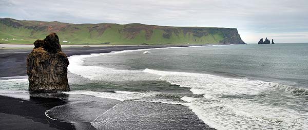
To bask in a land of mountains, glaciers, and rugged coastal scenery, head for Iceland’s South Coast. Within a 2.5-hour drive of Reykjavík, you’ll find black sand beaches, bird’s-eye-view promontories, gushing waterfalls, glacial tongues just finishing their slow-motion 500-year journey, museums on folk culture and volcanoes, and rolling green farm fields dotted with sheep, cows, and Icelandic horses.
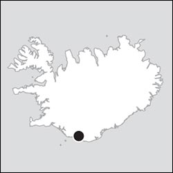
The towns here are humble, with sparse sights and services. Vík—at the far end of this day’s drive—has a fine setting under cliffs (with its own little black-sand beach) and several nice restaurants. The Þórsmörk nature reserve—accessible only via specially outfitted 4x4s or buses equipped with monster-truck tires—rewards hikers with stunning, panoramas over cut-glass peaks and ruddy valleys. All of this sits in the shadow of two glacier-topped volcanoes: Eyjafjallajökull and the even more powerful Katla.
PLANNING YOUR TIME
The South Coast rivals the Golden Circle and Snæfellsnes Peninsula as Reykjavík’s best side-trip, and it’s arguably even better for outdoorsy types, offering more nature activities and superb hiking. But it’s not a loop trip: Unless you’re doing the South Coast as part of the Ring Road, you’ll head home the way you came—making the scenery a rerun.
As a Day Trip: You can do the South Coast in a single long day (about 10-11 hours) from Reykjavík, either on your own—following the driving tour outlined in this chapter—or with a bus excursion. Various companies offer full-day guided excursions year-round (prices range from about 15,000 ISK to 19,000 ISK based on the group size; see the Beyond Reykjavík chapter for a list of tour companies). These don’t pack in as many stops as this chapter outlines, but they do hit the highlights, and some tours offer the option of adding on a glacier hike or other activities.
As an Overnight: While many people visit this area as a day trip from Reykjavík, the South Coast is well worth spending the night, giving you more time to explore (including side-tripping to the Westman Islands or Þórsmörk—each of which takes the better part of a day). The South Coast is a logical last stop if doing the clockwise Ring Road route, and it’s easy to add it to the Golden Circle drive from Reykjavík (instead of looping back to the city, end that drive here on the South Coast, where you can spend a night or two—and head straight to Keflavík Airport for your departure flight, without returning to Reykjavík). There’s just one catch to this plan: Accommodations here are quite limited and tend to book up early (see “Sleeping on the South Coast,” later).
South Coast Drive
This drive links up the main attractions along the South Coast, in the order you’ll reach them from Reykjavík. (Those ending their clockwise Ring Road drive will see these sights in the opposite order. Just hold the book upside down.) It’s about a 2.5-hour, 115-mile drive one way between Reykjavík and the far point of this area, the town of Vík. Adding in time for a few necessary side roads, plan on at least six hours behind the wheel, plus about five hours to visit sights along the way. Figure on about 11 hours for the full round-trip experience.
The basic plan: From Reykjavík, make good time on highway 1 across the desolate Hellisheiði plateau, then through the towns of Hveragerði, Selfoss, Hella, and Hvolsvöllur (with the Lava Center volcano exhibit). Just beyond—1.5 hours after leaving the capital—you’ll cross the river Markárfljót and enter the most striking part of the drive. The stops along this stretch are captivatingly Icelandic: Hike behind the thundering Seljalandsfoss waterfall, ogle the glacier-capped Eyjafjallajökull volcano, and pause in Skógar to see another towering waterfall and a fine folk museum. Next, hike up close to the icy tongue of the Sólheimajökull glacier, enjoy the views from the Dyrhólaey promontory, and stroll along the black sand beaches at Reynisfjara. Just beyond those sights, the village of Vík has a big gas station and restaurants, offering a handy pit stop before starting the 2.5-hour drive back to Reykjavík.
PLANNING YOUR DRIVE
This plan is designed to efficiently link the highlights of Iceland’s South Coast:
| 9:00 | Leave Reykjavík and head for your first stop: Skógar (2 hours); you might be tempted to pull over at the Seljalandsfoss waterfall, but save it for the way back (in late afternoon), when the light is better |
| 11:00 | Visit the Skógafoss waterfall and Skógar Folk Museum; then have lunch |
| 13:30 | Head for Sólheimajökull (15 minutes) and walk to the glacier |
| 14:45 | Drive to Dyrhólaey promontory (20 minutes) for the view |
| 15:30 | Depart for Reynisfjara (20 minutes) and walk the black sand beach; if time allows (or if you need gas or food), drive a few minutes to the end-of-the-road town of Vík |
| 17:00 | Double back to the Seljalandsfoss waterfall (1 hour) |
| 18:30 | Drive back to Reykjavík (1.5 hours); consider stopping for dinner en route |
South Coast Tips
Visit Seljalandsfoss Last: The sun shines on the Seljalandsfoss waterfall in the afternoon, making this scenic stop even more dramatic and picturesque; in the mornings the mountain shadows it. For the best light (and possible rainbows), visit in the afternoon, on your way back to Reykjavík.
In Bad Weather: Consider stopping at the Lava Center in Hvolsvöllur in the morning. Both the Lava Center and the Skógar Folk Museum become more worthwhile in poor weather—and offer a dry place to take a break from the elements. If there’s no sun in the forecast, it’s less important to hit Seljalandsfoss last; you could stop at the waterfall in the morning on your way to Skógar.
With More Time: If you’re willing to leave earlier, get back later, or spend two days, your South Coast experience will be more leisurely. For example, rather than driving straight back for a late dinner in Reykjavík, consider having dinner in Vík and taking your time enjoying the evening light and lack of crowds as you retrace your route back to the city. Alternatively, you could enjoy a countryside dinner on your way back (for ideas, see “Vík Back to Reykjavík,” at the end of the drive).
If overnighting on the South Coast, you can add more sights: Stop at the Hellisheiði geothermal power plant, check out the Bobby Fischer Center and his nearby grave, visit the Lava Center in Hvolsvöllur, day trip by ferry to the Westman Islands, or hike at Þórsmörk.
Visiting the Westman Islands: In clear weather, you’ll see the Westman Islands—one of Iceland’s most underrated destinations—hovering just offshore. The ferry to the islands is a quick 10-minute spur off highway 1, plus a 40-minute crossing. With an extra day, side-trip to the islands, or ferry over the end of your South Coast day and spend the night. For more on this lovely destination, see the Westman Islands chapter.
Enjoy the Viewpoints: There’s generally a pullout with picnic benches at any great viewpoint. Stop for a snack, read the information boards, and savor the views.
Hiking at Þórsmörk: The mountain ridge and valleys of Þórsmörk (described at the end of this chapter) are a hiker’s delight but take the better part of a day to experience. If sleeping along the South Coast, you can catch a bus to Þórsmörk from Hvolsvöllur.
Weather Warnings: Visiting waterfalls and glaciers can be cold and wet; dress warmly and bring waterproof clothing and footwear. Also, be aware of the risk of blowing sand (which can damage your rental car’s finish, at your expense). There is a small sandy patch (just a few hundred yards long) at the bridge where highway 1 crosses the Markárfljót river, just before the Seljalandsfoss waterfall. If very high winds are forecast (check http://en.vedur.is), consider alternative plans. For more information, see “Driving Hazards” in the Practicalities chapter.
To the South Coast and Back
REYKJAVÍK TO SKÓGAR
Once you’ve left Reykjavík, it’s just over a two-hour drive southeast along highway 1 to Skógar, a small settlement near the Skógafoss waterfall. Along the way, you’ll pass some functional towns—Hveragerði, Selfoss, Hella, and Hvolsvöllur with a few minor sights. You’ll also pass the magnificent Seljalandsfoss waterfall (if sun is in the forecast, save the waterfall for your return drive; see “Planning Your Drive,” earlier).
• Just a few minutes after leaving Reykjavík’s suburban sprawl on highway 1, you’ll find yourself at...
Hellisheiði
The 1,200-foot pass called Hellisheiði is a starkly desolate volcanic landscape, where you could easily encounter bad weather in April or October. If you have time, consider a stop at the Hellisheiði ON Power Plant, with an exhibit on geothermal energy (2,000 ISK, closes at 17:00 so stop at the start of your trip if you’re interested; see here).
From the side road that leads toward the power plant, you can turn right to reach the compact but enjoyable Hveradalir Geothermal Area (park in the big lot for the ski lodge, Skíðaskálinn). A modern walkway leads across a hazy, bubbling, smelly field with several very active steam vents and a big, gurgling mud puddle, all explained by posted descriptions. It’s not as exciting as Mývatn or even Geysir, but if it’s your only chance to experience a geothermal field, it’s worth a few minutes.
Back on highway 1, you’ll soon reach the edge of the plateau and drop down on a switchback road. In good weather, you’ll enjoy great views over the southern lowlands. Below you is the town of Hveragerði, at the head of an evocative valley misty with steam vents. (The town’s name, aptly, means “hot spring enclosure.”) The top end of this valley is where intrepid bathers can hike an hour up to the thermal river at Reykjadalur (get details before leaving Reykjavík; see here).
• About 10 minutes past Hveragerði, you’ll reach the large town of Selfoss (population 7,000), with a full range of services. Continue on highway 1 as it skirts the northern edge of Selfoss, following signs toward Vík and Hella.
But if you’re intrigued by American chess grandmaster Bobby Fischer and his connection to Iceland, you may want to briefly stop in Selfoss at the small museum about his life and make a short detour to his grave.
Bobby Fischer Center
This small but interesting museum, on the top floor of a multiuse building on the main street in Selfoss, hosts an impressive collection of Bobby Fischer memorabilia, including the table on which he played the famous “Match of the Century” against Russian Boris Spassky and his infamous revoked passport (see sidebar). The highlight is learning about his special relationship with the Icelandic people: Paintings, poems, and photos show how this complicated genius was embraced by the Icelandic community that looked after him in his last years. The last known portrait of him is particularly poignant (1,400 ISK, daily June-early Sept 13:00-17:00, off-season by appointment only, Austurvegur 21, +354 894 1275, www.fischersetur.is).
To visit his nearby gravestone, continue to the east end of Selfoss (the far end, if coming from Reykjavík), look for the Laugardælakirkja sign, and turn left down a side road. In less than a mile, you’ll reach a small church at the Laugardælur farm (you’ll practically drive through the farmyard). His humble gravestone is easy to find, just inside the churchyard gate (and often adorned with chess pieces).
• From Selfoss, highway 1 continues east across a lush plain, eventually passing through two small towns…
Hella and Hvolsvollur
Each town has about 1,000 people, a grocery store, a couple of places to eat, a thermal swimming pool, and gas stations with WCs (you’ll also find several recommended accommodations nearby). If you’re here on a weekend and need a coffee or light lunch in Hella, the $ Auðkúla Dome Café is a peaceful oasis (open Fri-Sun only, located down a small dirt road before you reach the town’s roundabout; look for the tiny Audkula sign on the left). It’s run by charming Birna and Pal in a half-sod house/half-geodome filled with tropical plants and cacti, gentle music, and fun decorations (they also rent two cottages with outdoor showers; www.audkula.is).
• Continuing along the main road through Hvolsvollur (KVOLS-vurt-lur), you’ll next come to the Lava Center. Even if not touring the center, it makes a handy WC stop—the lobby (with some informative exhibits) is free to enter.
▲Lava Center
This state-of-the-art attraction rivals the excellent Volcano Museum in the Westman Islands and uses clever exhibits to explain Iceland’s volcanic heritage. While expensive, it’s well presented and enjoyable for all ages and interest levels. But in good weather, the center pales in comparison to this region’s outdoor attractions. It’s a better option if your South Coast day is socked in.
Cost and Hours: 4,390 ISK includes exhibit and film, 1,700 ISK for just the film, family ticket available; daily 9:00-18:00, can’t miss it along highway 1 at the western edge of Hvolsvöllur, +354 415 5200, www.lavacentre.is.
Visiting the Museum: In the free-to-roam lobby, you’ll find a large virtual map of Iceland identifying minor earthquakes over the last 48 hours. Smaller screens cycle through recent eruptions. Check out the cross-section of soil excavated at this site, striped with ash and tephra deposits from eruptions over time. (The lobby also has WCs and a branch of the Rammagerðin gift shop.)
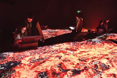
To reach the exhibit, head down the long, pulsing timeline corridor, pinpointing significant eruptions over Iceland’s geologic history, with a comparison of each eruption’s lava and tephra volumes. You’ll eventually come to a towering, glowing mantle plume (representing a “hot spot” of molten rock gushing upward to Iceland from the Earth’s core) and manipulate eerie and mesmerizing simulated lava flows on tabletops. Throughout, touchscreens and video walls invite you to learn more, and darkened corridors between the rooms add to the experience—with simulated ash clouds, noisy eruptions, and trembling floors. In the Volcano View room, you’ll stand in the middle of wraparound, wall-to-ceiling virtual footage of what eruptions in this area would look like.
In the cinema, a 12-minute film playing three times an hour shows off high-definition footage of spitting and flowing lava; historic photos and videos of past eruptions; and aerial scenery of volcanic landforms around Iceland. Stairs next to the cinema lead up to an observation deck, where you’ll get views of the surrounding volcanoes (an information panel points them out).
• From Hvolsvöllur (famous only as the home of the Icelandic hot-dog factory on the left), it’s about a 15-minute drive to the bridge over the Markárfljót river. Directly after the bridge is the turnoff onto highway 249 for the Seljalandsfoss waterfall (see the description at the end of this drive). Bypass the waterfall now if decent weather is expected in the later afternoon, when the light is much better, making for a more satisfying visit (and better photos).
Continue east on highway 1. Out at sea, the horizon is fringed with the jagged cliffs of the Westman Islands, formed by volcanoes and known for their seabird colonies (especially puffins) and folk music. The terminal for the Westman Islands ferry (a 40-minute trip) is a few miles south of highway 1 (see the Westman Islands chapter).
About 15 minutes beyond Seljalandsfoss you’ll reach the...
Eyjafjallajökull Area
The Eyjafjallajökull ice cap you’re driving under sits atop a volcanic mountain peak that famously erupted in April 2010. The fine-grained ash ejected high into the atmosphere halted air travel in Europe for nearly a week. (For details, see the sidebar.)
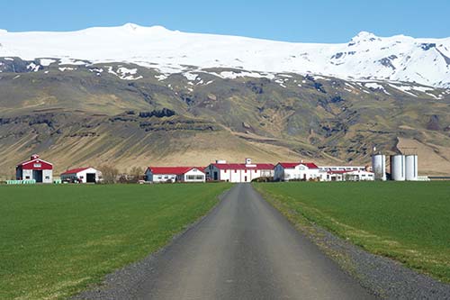
Once a fjord, the land around here was filled in over the ages with glacial debris. Looking inland, you can imagine the cliffs plunging into the sea here 10,000 years ago. Farther inland is the vast natural preserve called Þórsmörk (see the end of this chapter), tucked in between three glacier-topped volcanoes: Eyjafjöll, Katla, and Tindfjöll.
Venerable farms dot the countryside. Well into the 20th century, most people on the island lived in turf homes on country farms like these. These days, it’s tough for farms to be profitable. Hay is the main crop here—used to feed sheep, cows, and Iceland’s unique breed of horses. Once part of the local farm economy (and diet), Icelandic horses are now raised more as a hobby, for tourism, and for export to enthusiasts worldwide.
The Icelandic volcano called Eyjafjallajökull (EH-ya-FYAH-tla-YUR-kutl) erupted in the spring of 2010, famously disrupting airline flights all over Europe.
The first, short stage of the eruption started late on the night of March 20, 2010, at Fimmvörðuháls, the saddle between the Eyjafjallajökull and Mýrdalsjökull glaciers (where the hiking path crosses between Skógar and Þórsmörk). Tongues of red-hot lava, some as much as 600 feet high, shot up along a short fissure. This was a real “tourist eruption:” The curious could view the show by helicopter, or even hike up toward it, in relative safety.
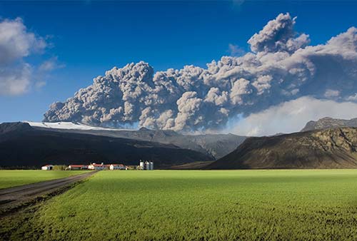
The Fimmvörðuháls eruption died down within a few weeks, and for all anyone knew the whole thing was over. But then came the eruption’s second stage, much more violent and dangerous, as the earth opened right in the middle of the glacier. On April 14, a column of black soot and smoke shot four miles into the sky, meltwater rushed down the slopes, and ash rained over the downwind countryside—covering fields, cars, and roofs. The ash blocked out the sun and put livestock in danger. Flights across Europe were canceled because of the fear that windborne ash would disable jet engines. Paradoxically, Iceland’s Keflavík Airport (upwind of the volcano) mostly stayed open throughout the entire eruption.
The second stage lasted until late May, and by August, the volcano was dormant. Thankfully, despite its international infamy, the Eyjafjallajökull eruption caused little real damage—other than dumping a considerable amount of ash on the nearby countryside. Its main legacy was confronting the world with how difficult long Icelandic words are to pronounce. If you’d like to master the pronunciation of Eyjafjallajökull, several YouTube videos offer a tutorial...or you can use its nickname: E15 (that’s E followed by 15 letters).
Eyjafjallajökull had an even bigger impact on tourism. Some experts believe that those headlines in 2010 reminded the world not only that Iceland exists, but that it’s a geologically fascinating place. They credit Eyjafjallajökull, in part, for the recent spike in international visitors.
So, when’s the next eruption on the South Coast? Historically, eruptions of Eyjafjallajökull have been followed by eruptions of Katla (under Mýrdalsjökull)—which last blew its top in 1918 and, according to volcanologists, is overdue. Stay tuned...
• If you’re hungry by now, look for the gray metal building with a rusty sign of a cow attached to it.
Eating near Eyjafjallajökull: Located at a roadside farmstead, $$ Gamla Fjósið (Old Cowshed) specializes in simple but satisfying steak sandwiches, burgers, and soup made with beef raised right here. From the outside it doesn’t look like much, but the inside is rustic and cozy, with mismatched furniture under open rafters. If you avoid the pricey fish and seafood dishes, it’s a decent value. Their “Volcano” soup (beef goulash) makes a hearty and affordable lunch, and seconds are free (long hours daily, Hvassafell, +354 487 7788).
• A few minutes after passing the restaurant, look for a pullout with picnic benches and informational plaques (next to the Þorvaldseyri farm’s driveway).
Thermal Bath Detour: Hardy bathers can consider a detour to Seljavallalaug, a very rustic thermal swimming pool (from 1923) built right into the side of a mountain slope. Some people enjoy the pool’s scenic and remote location, which requires a mostly flat 20-minute hike into a desolate valley (while you can’t see the pool until you reach it, just keep following the river straight ahead; you may need to cross a small stream along the way). Don’t expect a sleek and sanitary experience: The pool is unstaffed and has very limited services (grubby changing rooms), and the water is warm rather than hot (and may be full of algae). But backpackers and campers looking to take a memorable dip enjoy the detour. (From highway 1, just beyond the Gamla Fjósið restaurant, watch on the left after the bridge for road 242 to Raufarfell, then follow signs for Seljavellir to the end of the road, where you can park and hike.)
• Continuing along highway 1, after about four miles, watch on the left: You’ll see rustic old buildings embedded into the sides of massive rocks.
Cave Houses: These huts were built to shelter animals and warehouse supplies, but they’re a good reminder that, well into the 1800s, Icelanders lived in dwellings much like these.
The first rock house—Rútshellir—has a handy roadside pullout and an information board. The structures you see grafted onto the stone are just the entrances to the sprawling, hand-carved cave. At a pullout a bit farther on, there’s a second house called Drangshlíð II (it’s private property, so you’ll only get a glimpse from afar).
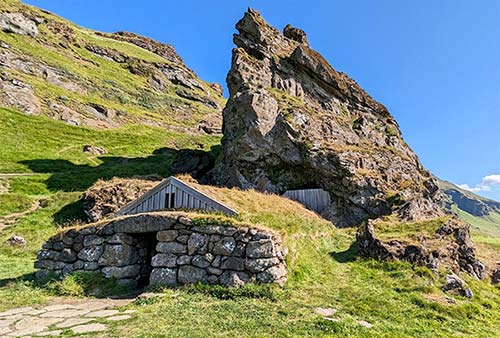
While I’m not much for Iceland’s “hidden people” legends (see sidebar), these sights are intriguing enough to warrant some fantastical stories. The cowsheds are said to be peopled by elves who look after the livestock...and prefer to do it without human interference. According to legend, the farmer would leave hay and an empty milk bucket outside the sheds, then later discover that the cows had been fed and milked.
• Soon after Drangshlíð II, watch on the left for a dramatic waterfall (our next destination) and then the turnoff to a small settlement called...
Skógar
Skógar (SKOH-ar, “Woods”) was originally the site of a local district school. There are two main attractions here: the Skógafoss (SKOH-gah-foss) waterfall (which you can’t miss, on your left) and the Skógar Folk Museum (to the right).
▲▲Skógafoss Waterfall
Park in the free lot (with pay WC) and gaze up at the water plunging down. This broad and powerful waterfall drains down from Eyjafjallajökull. For another perspective on the rushing water, climb the stairway (about 500 steps) all the way to the brink of the falls. The stairway is actually the start of a long, popular trail that continues all the way up over the saddle between the Eyjafjallajökull and Mýrdalsjökull glaciers, and over to Þórsmörk (requires good preparation; for more on the Þórsmörk area, see the end of this chapter).
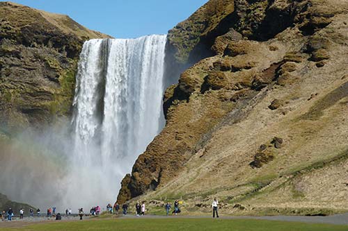
Eating at Skógafoss: Of the cluster of restaurants near the falls, $$ Hótel Skógafoss Bistro Bar is the best. The dining room and outdoor deck have nice views and a fine menu of lamb, fish dishes, burgers, and soup (long hours daily, +354 487 8780).
▲Skógar Folk Museum
This large and impressive collection, with indoor and outdoor areas, is beautifully presented and organized. It’s worth the entry price for those who’d like to mix some museum-going into their South Coast day. On a rainy day, or for those who need a break from the natural sights, it’s worth ▲▲.
Cost and Hours: 2,500 ISK, daily 9:00-18:00, Sept-May 10:00-17:00, +354 487 8845, www.skogasafn.is. The museum’s Freya Café is a flowery tearoom with some decent lunch options (same hours as museum).
Visiting the Museum: The site has two exhibit halls and an open-air museum, with most exhibits described in English. The ticket desk is in the building with the excellent regional history museum. Its three floors showcase old household goods, farm implements, local archaeological finds, an 1855 fishing boat with a photo of its crew, a whale vertebra made into a bucket, and more artifacts that give a rare and vivid look at Iceland in the 19th century. Displays in the basement include a large collection of stuffed Icelandic wildlife.
The adjacent building contains the café and a transport and communication museum. A one-way route snakes through a huge hall cluttered with artifacts. Exhibits explain how Iceland entered the modern age (showing how, for example, in the early 1900s, a phone line was strung across the island and a cable laid to Europe). In addition to lots of shined-up old cars and rescue equipment, you’ll wander past neatly arranged piles of all kinds of devices—like radio transmitters—and entire walls lined with first-generation cell phones.
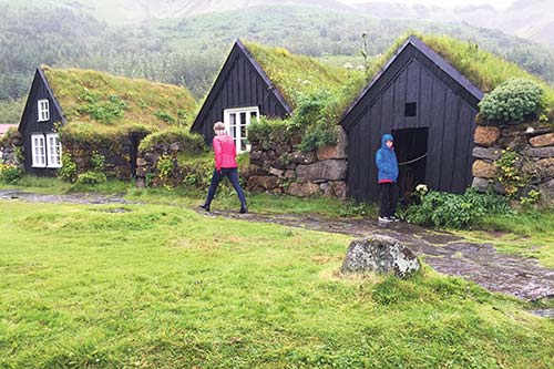
In the field behind the two buildings is a small open-air museum with original buildings moved here from elsewhere in Iceland, including two sod-roofed farmsteads (with stone walls and labyrinthine passages), an old timber house (from 1878, built of driftwood and wood salvaged from a French shipwreck), and a school building—each traditionally furnished. The little church itself is not old—it was built here in the 1990s—but the furnishings inside are centuries-old originals, salvaged from other churches in the region.
SKÓGAR TO VÍK
This stretch—a half hour’s drive without stops—is lined with a few more attractions and detours, starting with the Sólheimajökull glacier.
• Less than 10 minutes past Skógar (just past the bridge), look for signs to Sólheimajökull. Turn left off the main road, slalom through the glacial debris for five minutes along paved highway 221, then park in the pay lot at the end of the road.
▲▲Sólheimajökull Glacier
Sólheimajökull (SOHL-HAY-ma-YUR-kutl, Sun-homes Glacier) is one of Iceland’s most accessible places to get close to a glacier. Allow about an hour for a quick visit.
From the parking lot (pay WCs in the Icelandic Mountain Guides building), walk about 15 minutes down a wide, rocky gravel track toward the glacier. (The walk gets longer each year as, like nearly all glaciers, this one is retreating with climate change.) You’ll reach a sign telling you not to proceed farther. There are several reasons for this: Melting ice under sand can create a quicksand-like phenomenon, poisonous volcanic gas can be released from under the glacier, ice calving off the glacier can create small tidal waves on the lagoon, rock can slide down the slope, and people can simply slip and fall into the cold lagoon.
Icelandic folk tales often speak of “hidden people” (huldufólk)—mystical sprites, elves, and other little creatures who inhabit a parallel universe.
According to legend, these hidden people look, dress, and live much like humans, only smaller. They’re farmers and fishers, and typically live inside rocks and hillsides. Hidden people are invisible to normal humans—unless they choose to be seen.
Most hidden people have no interest in humans, they sometimes need our help, and they aren’t shy about retaliating if disturbed. (After experiencing mysterious equipment malfunctions, construction projects have been known to reroute a road or carefully move a boulder—or even consult a mystic to negotiate with the hidden people.) And some mischievous hidden people take advantage of humans. For example, a truculent elderly elf might be switched out for a human baby as a changeling—to make him some poor Icelander’s problem.

Tales of Icelandic hidden people date back to the earliest years of the Settlement Age. It’s no coincidence that the stories told in this rugged, sparsely inhabited land feature many instances where showing generosity to a stranger is richly rewarded. These tales remind Icelanders to fear and respect nature—and on this island of volcanoes, earthquakes, and steaming geysers, nothing could be more rational. It’s also notable that the original Icelanders arrived on an empty island and found no native inhabitants to subdue...so they invented some.
You may see polls suggesting that many Icelanders are open to the possibility that hidden people truly exist. A few even claim, matter-of-factly, to have seen an elf walking across their lawn. But many Icelanders—particularly younger ones—roll their eyes at talk of hidden people. In their view, these “beliefs” are exaggerated by the media, by local tour guides, and in guidebooks like this one.
In the 19th century, a pair of Brothers Grimm-style scholars—Jón Árnason and Magnús Grímsson—collected Iceland’s tales of hidden people. To read a variety of vivid folk stories, search for “hidden people folktales” at GrapeVine.is; for a more scholarly compendium, books in English include J.M. Bedell’s Hildur, Queen of the Elves: And Other Icelandic Folk Tales. For a concise overview, see Alda Sigmundsdóttir’s The Little Book of the Hidden People or Icelandic Folk Legends.
Despite these dangers, most visitors choose to keep going, walking across uneven ground to the glacier itself. If you continue past the sign, use common sense, stay near other visitors, and keep in mind that the snout of the glacier is always moving and changing, along with ice and meltwater conditions. In recent years, it’s been easy to walk right up to the ice and give it a loving pat. But rock falls or rushing streams may force you to stay back. (You’ll likely notice helmeted glacier-hiking groups actually walking on the glacier with their guides.)
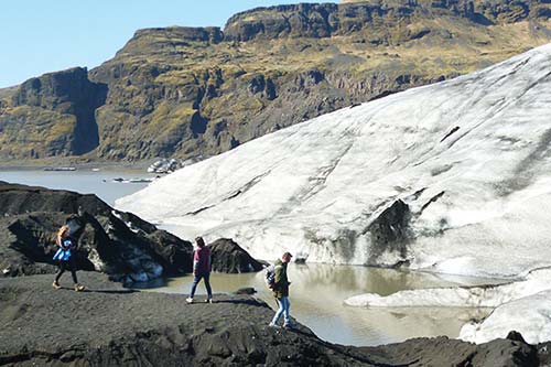
If you’ve never seen a glacier before, you may be surprised at how dirty it is. Brilliant whites and pale blues alternate with sections where the surface is covered in black grit. You can watch a good time-lapse sequence of its receding extent at ExtremeIceSurvey.org.
Something else to ponder: A generation ago, the glacier reached all the way to the parking lot (saving visitors a walk). Politicians may squabble over climate change, but Icelanders will tell you that there’s no question their glaciers are receding. In western Iceland, the Okjökull glacier receded to the point that it lost its glacier status—now it’s just called “Ok.” That’s not OK.
Guided Hiking on the Glacier: To climb on the glacier, you must be properly outfitted and travel with a group for safety’s sake. Many companies offer excursions of varying lengths and difficulty that take you up on Sólheimajökull. Some companies offer glacier hikes as a day trip from Reykjavík, but you can also join an excursion on-site.
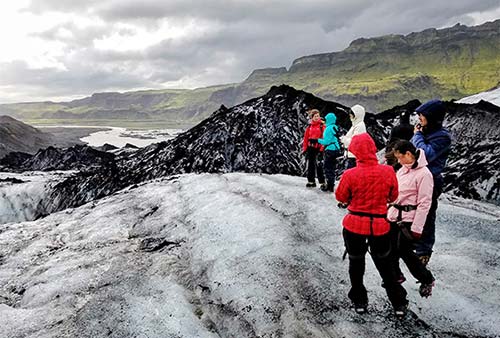
Icelandic Mountain Guides runs guided glacier hikes several times a day from a building next to the parking lot. Their three-hour glacier walk (worth ▲▲) takes you past the iceberg-filled lagoon to the glacier’s snout, where you attach crampons to your boots for the climb through spooky canyons of ice and black ash up to the smoother surface on top of Sólheimajökull. Along the way your guide explains how glaciers form and behave, where those mysterious cones of coarse black ash come from, how massive sinkholes appear, and how climate change is killing the glacier (as evidenced by the vast amount of water flowing on and through the ice).
Groups go out rain, wind, or shine—or in all three. Wear sturdy hiking boots, dress in layers, and have waterproof outerwear and gloves handy (you can rent some gear here before setting out).
While you can just drop in and see what’s available, it’s best to book in advance (3 hours-16,000 ISK, 4 hours-19,000 ISK, 4-hour glacier hike with ice climbing-24,000 ISK; +354 587 9999, www.mountainguides.is). For more about glacier hikes, see the “Glaciers” section of the Icelandic Experiences chapter.
Nearby: You might hear about Sólheimasandur, a desolate beach where you can see the remains of a DC-3 plane that crash-landed in the 1970s (everyone survived). The corroded fuselage lies close to the sea on the sandy wastes near the turnoff to Sólheimajökull. But unless you’re an aviation nut, skip it—there’s nothing to see besides the empty fuselage. It’s either a dull 2.5-mile hike each way from the trailhead parking lot at the highway, or you can take the “shuttle” that goes back and forth throughout the day for a ridiculous 2,900 ISK.
• Back on highway 1 continue east 10 minutes, then turn right onto highway 218. In five minutes, you’ll cross the causeway to the Dyrhólaey promontory. The left fork (signed Lágey) takes you to the lower parking lot, with views across the long, broad black-sand beach toward Reynisfjara. The right fork (signed Háey) leads to the upper parking lot, lighthouse, puffin-watching, and more impressive views. I’d start with the high road.
▲▲Dyrhólaey Promontory
The Dyrhólaey (DEER-hoh-la-AY) promontory sits above a nature reserve with a lighthouse, natural sea arches, and picturesque offshore rocks.
At the Upper Parking Lot: For some grand views, head (very carefully) to the giant, flat-topped overlook. From up there, you can see virtually the entire South Coast—with the open Atlantic on one side and glacier-capped volcanoes on the other.
Then, from the parking lot, do a little five-minute loop (straight ahead) to the lighthouse and beyond. At the bluff beyond the lighthouse (marking the southernmost point of the Icelandic mainland), you can look down over sea stacks, bird cliffs, and a dramatic sea arch.
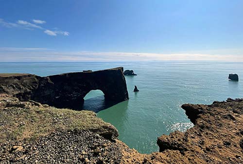
At the Lower Parking Lot: From here, an easy five-minute trail leads to a viewpoint overlooking a black sand beach that stretches all the way to Reynisfjara (described next). If you’d prefer a steep, uphill climb (rather than driving), you can hike from here to the lighthouse above.
Seabirds: In early summer, the cliffs around you teem with seabirds (including, often, puffins). Note, however, that from early May to late June, part or all of Dyrhólaey may be closed to car traffic (and maybe even to hikers) to protect nesting birds. Even if the area is open, avoid getting too close to nests; arctic terns aggressively dive-bomb tourists who accidentally wander near their eggs.
“Mirror Beach”: Depending on the time of day and conditions, you may enjoy an added attraction on the causeway to Dyrhólaey (on the left as you approach from the mainland). At low tide, late in the day, the sunlight sometimes reflects off the black sand just below a very thin layer of water, turning the bay into one big mirror. If you see cars parked along the causeway, pull over and join in the fun of “walking on water.”
• Return to highway 1 and continue east almost 10 minutes, then turn right onto paved highway 215, following signs for Reynishverfi (the settlement next to the beach). Along the way you’ll drive through a broad, lush, green farmland delta. In the pastures, cows graze contentedly—a relatively rare sight in Iceland, where they’re mostly kept indoors. Another five minutes brings you to a big pay parking lot with WCs and a beach café (if the weather’s nice and you’re arriving midday, consider pulling off into the first overflow lot on the right and walking down the short path; the main lot can be slammed). From the parking lot, it’s a couple minutes’ walk to...
▲Reynisfjara Black Sand Beach
Tucked under grassy mountains, at the far end of the bay from Dyrhólaey, Reynisfjara (RAY-nis-fyah-rah) is worth ▲▲ on a nice, calm day. The beach itself changes with the ocean currents—sometimes it’s full of small black pebbles and sometimes it’s a fine sand. The sand can bank up higher or be partially swept away. The tide has an effect, too. In exceptional conditions, a very high tide can flood the parking lot. In winter, all but a thin strip of black sand may be covered by snow.
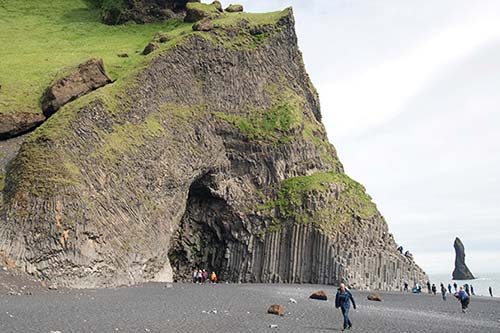
Looking out to sea, on your left you’ll see dramatic basalt formations—splintered hexagonal columns of volcanic rock, evocative of the famous Giant’s Causeway in Ireland. Kids enjoy scrambling up the uneven stairsteps formed by the splintered rock of this pyramidal cliff, known as the Garðar (Stronghold). Scan the grassy areas above the basalt columns for nesting puffins in summer. If the tide is out, circle around to the left to explore shallow caves framed by even more fantastical formations—columns thrust at unlikely angles and rock cascading in paper-thin layers.
Just beyond the basalt caves, in the water, are the jagged Reynisdrangar sea stacks—the sea-eroded remnants of an ancient basalt cliff. Scanning the horizon to the right, you’ll see all the way to the Dyrhólaey promontory with its dramatic arch. Virtually everyone on this beach crowds in the small area near the parking lot. If the weather’s fine, it’s worth strolling away from the crowds to have this giant, broad beach all to yourself.
Caution: The beach here is inviting...but dangerous. It’s fine to walk along the black sands but stay well back from the water—much farther back than you think is safe—and never turn your back to the sea. The sea is strong here, with an undertow; several tourists have drowned, and there are close calls every year. Frequent sneaker waves—huge, unexpected surges of water—swamp areas of the beach that looked dry a minute before.
Eating at Reynisfjara: The cafeteria-like $ Black Beach Café, also known as Svarta Fjaran, serves simple grill meals (daily June-Aug until 19:30, shorter hours off-season, +354 571 2718, www.svartafjaran.com). There’s also a tiny hot-dog food truck.
• If you’re tired or short on time, you could head back to Reykjavík now (but be sure to stop at Seljalandsfoss waterfall on your way back). Otherwise, continue on to...
Vík
A 10-minute drive over a low pass beyond the Reynisfjara turnoff, Vík (pop. 300) is Iceland’s southernmost village and the endpoint of this drive. Vík enjoys a stunning setting—huddled up against a craggy cliff, with green pastures all around and a pointy steeple overlooking the town center from its plateau perch. But the town itself is more practical than charming. Most people use it simply as a turnaround spot to Reykjavík.
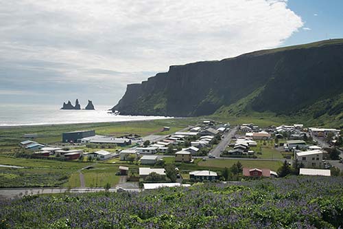
Vík Church Viewpoint: From highway 1, turn left (on the road marked Suðurvíkurvegur) and drive uphill to the village church’s parking lot for a grand view of Vík, adjacent cliffs, jagged dragon’s-teeth sea stacks just offshore, and long stretches of the South Coast.
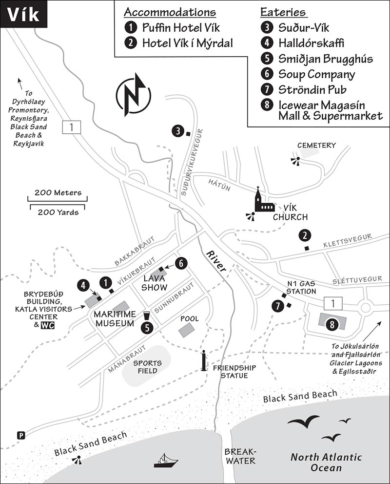
“Downtown Vík”: To head into town, turn right off the main road onto Víkurbraut street. Two blocks down on the right, the Brydebúð building (an 1831 storefront moved here from the Westman Islands) hosts the Katla Visitors Center (Kötlusetur)—a free exhibit on the local volcano (Katla) and the eruptions at Fimmvörðuháls and Eyjafjallajökull. The friendly staff is happy to explain the region’s volcanic history and can outline options for nearby hikes (at #28, daily May-Aug 10:00-17:00, shorter hours off-season, nice gift shop, WC, lively recommended café next door, +354 487 1395, www.kotlusetur.is).
Maritime Museum: Across the street from the Katla Visitors Center, the little Skaftfellingur Museum is a dusty warehouse displaying the rickety remains of a beloved local ship (500 ISK, pay at the Katla Visitors Center, June-Sept Mon-Fri 10:00-18:00, Sat-Sun until 16:00, shorter hours off-season). The Skaftfellingur was built in 1918, served during World War II, and decommissioned in 1963. The museum works hard to spin nostalgic stories about Vík’s town heritage. One exhibit identifies the many shipwrecks that have occurred in the treacherous waters off Iceland’s South Coast.
Lava Show: This attraction, which has its primary outpost in Reykjavík, puts on an up-close demonstration of actual molten lava, using volcanic basalt from the 1918 Katla eruption (melted down in a furnace backstage). Read the full description on here, and if Vík is handier to your sightseeing plans than Reykjavík, consider attending the show here (advance booking recommended; 5,900 ISK, 3,500 for kids 2-12, 4 shows daily June-mid-Sept 11:00-20:00, off-season 2-3/day, Víkurbraut 5, +354 553 0005, www.lavashow.com).
Vík Beach: Vík has no harbor. Before the road arrived (in the 1940s), provisions came in via tough boats beaching here on the black sand. From the Maritime Museum, follow Víkurbraut street as it curves left and comes to a T; then turn right and look for the turnoff (on the left) that leads to a couple of beach parking lots. This remote and windy beach offers a breakwater, some blustery picnic benches, and nice walks.
Eating in Vík: For Vík’s version of finer dining, $$$ Suður-Vík, up the road near the church (go left at the fork), has a fun, cheery, attic-like space. Their à la carte menu is pricey but their good pizzas are cheaper (long hours daily, reserve ahead for dinner, Suðurvíkurvegur 1, +354 487 1515).
$$ Halldórskaffi, a busy, convivial café sharing the Brydebúð building with the Katla Visitors Center, serves reasonably priced meals from an enticing menu (fish, lamb, pizza, sandwiches; daily, +354 487 1202).
$$ Smiðjan Brugghús (Old Smithy Brewhouse) sells tasty brew-pub grub (burgers, BBQ ribs, vegetarian options) and a great selection of craft beers—including its own (daily, Sunnubraut 15, +354 571 8870).
$ Soup Company is a modern and efficient eatery serving up several good soups, including a spicy meat soup called “Red Hot Lava” (daily until 21:00, Víkurbraut 5, +354 778 9717).
$$ Ströndin Pub, behind the N1 gas station, serves elevated pub food with good sea-stack views (daily, Austurvegur 18, +354 790 1442).
For groceries, a big Krónan supermarket is in the made-for-tourists Icewear Magasín mall at the east end of town, by the N1 gas station. Here you’ll also find a restaurant, café, wool products, a huge souvenir shop, and free WCs (daily 9:00-22:00).
VÍK BACK TO REYKJAVÍK
It’s about 2.5 hours from Vík to Reykjavík without stopping—back the way you came on highway 1. But allow an extra 30 minutes for a stop at Seljalandsfoss for picture-perfect views of the impressive waterfall—and a chance to walk behind it. While I like eating in Vík and then enjoying the evening light on the drive home, you could break up the drive by eating on the way back to Reykjavík (see “Dinner Options between Vík and Reykjavík,” later).
• Head back on highway 1 (westbound), passing many of the sights we saw earlier in the day. After about 45 minutes, turn right onto highway 249 for...
▲▲Seljalandsfoss Waterfall
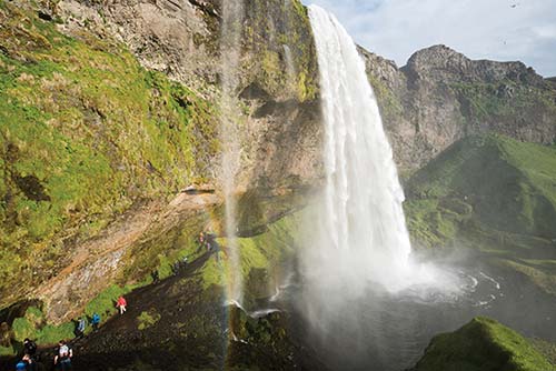
Seljalandsfoss (SELL-yah-lahnds-foss) tumbles over its cliff into a pool, with a cave-like walkway just behind it. The 210-foot-high falls aren’t that powerful—but they are handsome. The water comes from the glacier Eyjafjallajökull, atop the volcano that erupted in 2010. In good weather, a path lets you walk around the back of the waterfall; in icy conditions, skip it (it’s closed in winter). If you do walk the path, it’s easier to go counterclockwise. Wear a waterproof jacket and good shoes—the path is damp and uneven, and you’ll be sprayed steadily.
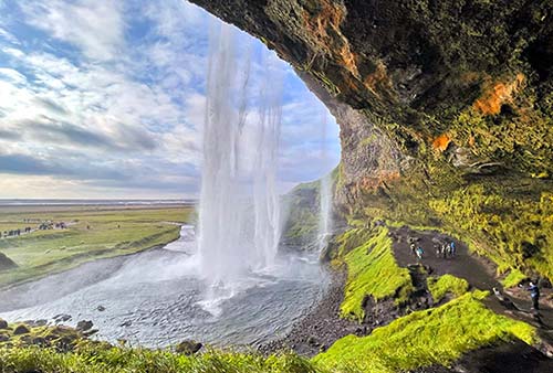
Cost and Hours: Seljalandsfoss is free to visit and open all the time—come during off-peak hours for a more peaceful experience. There’s a pay parking lot (900 ISK) and a little coffee shop.
Optional Add-On: A 10-minute walk down a path to the left of Seljalandsfoss takes you to another waterfall called Gljúfrabúi (GLYOO-vrah-BOO-ee, literally “Canyon Dweller”). This much smaller waterfall drops into a hollow within the rock and then exits (as a stream) under a tall, narrow, natural archway. To see it in its full glory, walk down the little path (with a handrail), and depending on the water level, you may be able to carefully navigate through the little gorge to emerge in a dramatic opening. At certain times of year, the water may be high and swift; at others, you may barely get your shoes wet. As always, it’s at your own risk.
Dinner Options between Vík and Reykjavík
On your drive back to Reykjavík, consider dinner at one of these restaurants (listed in the order you’ll reach them):
In the Eyjafjallajökull Area: For burgers and other beef dishes, Gamla Fjósið is a good place to stop (see listing on here).
Lobster Detour near Selfoss: About 15 minutes south of Selfoss are two restaurants highlighting humar (a.k.a. langoustine or Norway lobster). While pricey, these local places are good for a when’s-the-next-time-I’m-gonna-be-in-Iceland blowout feast. To find them from Selfoss, head south on highway 34 (at the main roundabout, turn off for Þorlákshöfn, Eyrarbakki, and Stokkseyri). From this area, it’s less than an hour’s drive back to Reykjavík (follow highway 33/34 west, then north on highway 39 to rejoin highway 1 near the Hellisheiði ON Power Plant).
$$$$ Fjöruborðið (The Water’s Edge) is a venerable, nautical-themed lobster house with simple but good dishes. It’s not cheap—a meal-sized bowl of lobster soup is 4,650 ISK, or you can pay (dearly) by weight for a sizzling skillet of humar tails. But it’s a memorable way to sample this coastal delicacy. Despite its name and waterside location, there’s no view (daily, reservations recommended, Eyrarbraut 3a, Stokkseyri, +354 483 1550, www.fjorubordid.is). To reach it from highway 34, when you hit the coast, turn left (east) on highway 33, to the village of Stokkseyri. The restaurant is in the back of the parking lot next to the big red Art Hostel.
$$$ Hafið Bláa (The Blue Sea) is perched scenically on a ridge by the beach. The food is slightly cheaper than at Fjöruborðið and not as well regarded, but the setting is far more striking: From the airy, modern dining room, you look north into the delta of the Ölfusá river, and south over crashing waves and a black sand beach that’s good for a stroll—especially to check out the massive lobster sculpture (daily, Óseyrartangi, between Porlákshöfn and Eyrarbakki, +354 483 1000, www.hafidblaa.is). It’s at the Ölfusá Bridge: Follow the directions above, but stay right (west) on highway 34.
In Hveragerði: Consider dinner at the satisfying Ölverk microbrewery/pizzeria (see the end of the Golden Circle chapter).
In Hafnarfjörður: An efficient option is to stop off in Hafnarfjörður for dinner on your way through Reykjavík’s suburban sprawl (see recommendations in the Reykjavík chapter).
Sleeping on the South Coast
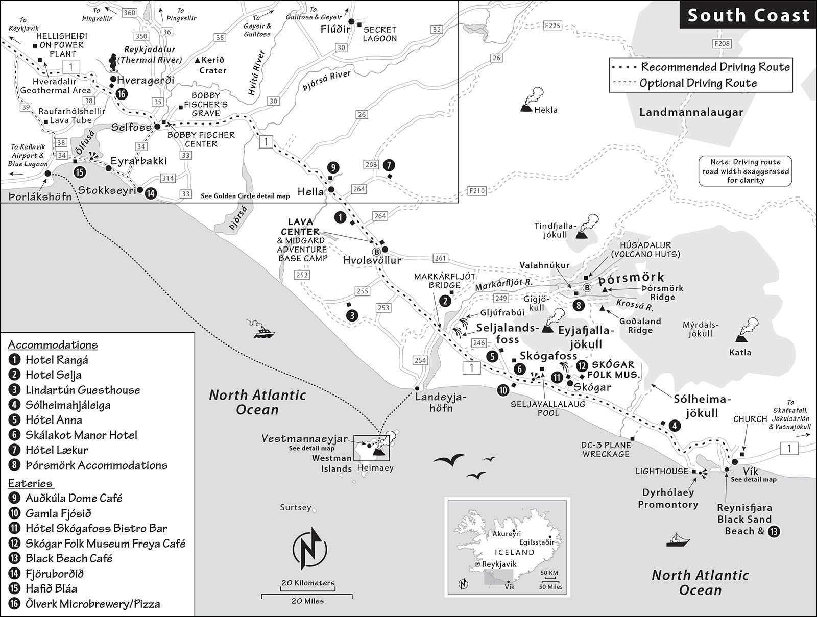
For locations, see the “South Coast” map, earlier in this chapter.
Near Hvolsvöllur: Named after the river it backs up to, $$$$ Hotel Rangá is a classic, high-end luxury resort with 51 woody and rustic rooms and inviting, lodge-like public spaces. They also have an observatory and offer a “northern lights wake-up service” in case of any late-night light shows. You’ll find three hot tubs to relax in, a pricey restaurant, and a comfy bar with overstuffed leather chairs and reasonable prices. If you’re looking to splurge on the South Coast, this is the place (5 minutes west of Hvolsvöllur on highway 1 at Suðurlandsvegur, +354 487 5700, www.hotelranga.is, hotelranga@hotelranga.is).
$$$$ Hotel Selja, just a couple of miles off the highway down an unpaved road, feels like a remote escape. The 12 rooms are bright and sleek (all with private bath), and some have views of the nearby volcanoes. The hotel is a 15-minute drive from the Westman Islands ferry terminal, so it makes a good pre- or post-islands base (discounts for stays of three nights or longer, on highway 250 at Dimonarvegur, +354 845 3324, www.hotelselja.com, stay@hotelselja.com).
$$ Lindartún Guesthouse, an unassuming place set amid horse and sheep pastures, offers nine modern yet cozy rooms (six with private bath) and two cabins. Friendly host Kristín runs a tidy ship and provides a hearty breakfast in her light-filled dining room (family rooms, take road 255 exit off highway 1, drive 5 minutes and guesthouse will be on the left, +354 552 5060, http://lindartun.is, kristin@lindartun.is).
Near Skógar: My favorite accommodation in this area, $$ Sólheimahjáleiga is a country-classy gem. This working farm—conscientiously run by the same family since 1875 (these days, Einar is at the helm, with help from Elín and Jónas)—is a tidy little compound with 250 sheep and 20 rooms split between new and old buildings. There’s a shared kitchen for guests to use, and dinner is available (family room, cheaper rooms with shared bath, just off the main road between Skógar and Vík, +354 864 2919, www.solheimahjaleiga.is, booking@solheimahjaleiga.is).
$$$$ Hótel Anna, roughly midway between Seljalandsfoss and Skógafoss, has seven good-size, warmly decorated hotel rooms, plus 10 well-appointed apartments with kitchenettes (four are ideal for families). Set in the foothills below Eyjafjallajökull, it’s a friendly, family-run place that also has a full restaurant and an atmospheric bar (hot tub, a couple of minutes off highway 1—coming from Seljalandsfoss, take the second road 246 exit signed Ásólfsskáli, +354 487 8950, www.hotelanna.is, hotelanna@hotelanna.is).
$$$$ Skálakot Manor Hotel is worthy of a splurge, with 14 rooms that ooze upscale-country charm. In a picture-perfect foothill setting, it’s the ideal place to unwind. Guests enjoy the full on-site spa and vast patio with a fire pit. Equestrians will also be in heaven—they offer several options for rides with their resident horses (elegant restaurant, Skálakoti, +354 487 8953, www.skalakot.is, info@skalakot.is).
Near Hella: Once an abandoned farm, $$$ Hótel Lækur has 21 rooms filling a renovated old barn and a modern annex, and four cottages with lofts that each sleep six. The owners have created a cheery, relaxing place where you can enjoy big-sky vistas and wander a grassy path along the creek (family room, hot tub, sauna, ice bath, full restaurant, 10-minute drive down highway 264 connecting Hella and Hvolsvöllur, near village of Hróarslækur, +354 867 4148, www.hotellaekur.is, laekur@hotellaekur.is).
In Vík: $$$ Puffin Hotel Vík is a charming place right on the main road (Víkurbraut 26, +354 467 1212, www.puffinhotelvik.is, puffinhotelvik@puffinhotelvik.is). They also run a fresh-feeling hostel across the street with several private rooms with shared bath.
For a more business-class stay, $$$ Hotel Vík í Mýrdal has 78 basic rooms in a handy but characterless location (Klettsvegur 1-5, +354 487 1480, www.stayinvik.is, reservations@stayinvik.is).
Þórsmörk
The Þórsmörk (THORS-murk) nature reserve encompasses a rugged mountain ridge and valleys immersed in a dramatic glacial landscape. This is one of Iceland’s premiere hiking destinations, with a well-marked network of trails that let you gain elevation for thrilling views over volcanoes, glaciers, and valleys.
Þórsmörk literally means “Thor’s Woods.” The scrubby stands of birch and willow at the far end of this valley, around Básar, constitute what Icelanders consider an impressive “forest.” (Locals only half-jokingly refer to this area as “The Jungle.”) About a century ago, these trees helped put Þórsmörk on the map, drawing curious visitors to see the last native forest on the South Coast.
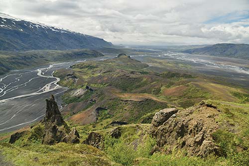
Þórsmörk is tucked between three volcanoes topped by glaciers— Eyjafjallajökull, Mýrdalsjökull, and the small Tindfjallajökull. It’s flanked by the wide Markárfljót river valley to the north, and the Krossá river valley to the south. The mountain ridge just south of the Krossá (near the Básar hut/bus stop) is called Goðaland—but in practice, the entire area is known as Þórsmörk.
For most visitors, half the fun of Þórsmörk is getting there: It’s accessible only on gravel roads that ford several rushing rivers and streams. While intrepid drivers (with specially equipped 4x4s) can attempt visiting Þórsmörk on their own, for the rest of us, jacked-up buses on monster-truck tires—or a pricey super-jeep tour—provide a memorable journey.
Þórsmörk requires the better part of a day. Many visitors do it as a long day trip from Reykjavík, while others home-base on the South Coast (the otherwise nondescript village of Hvolsvöllur, about 20 minutes west of the Seljalandsfoss waterfall, is a hub for Þórsmörk excursions). The information here is designed for one busy day—with an emphasis on its most rewarding hike, to the stunning Valahnúkur viewpoint (with 360-degree panoramas). This hike is moderately challenging and staircase-steep in parts.
If you’re not a serious hiker, carefully consider whether Þórsmörk is worth the expense and effort. On the upside, the ride in and out is still entertaining, the scenery is striking, and there are some easier hikes—but without a real hike, you’ll be missing that memorable cherry on top.
GETTING THERE
The drive into Þórsmörk is a ▲▲▲ experience in itself. Only specially-equipped 4x4 vehicles make the journey, which requires grinding over a rocky terrain and fording several churning glacial rivers. Local authorities periodically regrade the gravel under the rivers to allow cars and buses safe passage, but drivers must know exactly where the fords are. Throughout its course, the river you’ll be following (and crossing) splinters and remerges, and the flow can vary dramatically; the drive into Þórsmörk is never the same twice.
By Car: Unless you’re serious about off-roading, don’t plan on driving yourself to Þórsmörk. Driving here isn’t allowed by most car-rental companies unless you’ve reserved a specially equipped 4x4 vehicle for this purpose. Before heading to Þórsmörk, check current conditions (www.safetravel.is) and watch some YouTube videos to fully understand what you’re committing to. Drivers turn off highway 1 north on road 249, pass the Seljalandsfoss waterfall, then continue north to where the road turns to gravel. From there, the route hooks east and goes under several streams as it works its way along—and eventually through the middle of—the Krossá river to Þórsmörk.
By Bus: You can either bus all the way to Þórsmörk from Reykjavík (five hours one-way), or hop on a bus in Hvolsvöllur (or another nearby town) on the South Coast (two hours each way). Either way, these specially equipped buses are quite expensive (about 16,000 ISK round-trip from Reykjavík; somewhat cheaper from Hvolsvöllur). All buses run in summer only. While you can theoretically just hop on the bus, it’s smart to book ahead (once you’re confident that the weather is good enough to justify the trip).
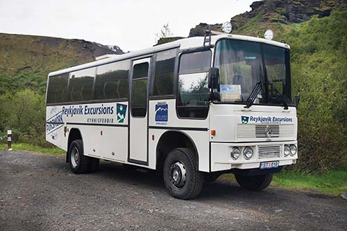
Two companies run the route from Reykjavík, making a few stops en route (if you are already on the South Coast and want to hop on a bus in Hvolsvöllur, contact the bus company in advance): Reykjavík Excursions (2/day June-Aug, 1/day in late May and early Sept, www.re.is/highland-bus) and Trex (2/day July-Aug, 1/day mid-June-mid-Sept, www.trex.is).
The locally based South Coast Adventure departs from Hvolsvöllur and other points nearby (3/day June-mid-Sept, 1/day late May and mid-Sept-Oct, www.southadventure.is).
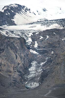
Stops Along the Way: On the way into Þórsmörk, some buses stop for a stretch-your-legs photo op at Gígjökull, a glacial tongue with the distinctive “split rock” from the 2010 eruption of Eyjafjallajökull. (There’s also a good, relatively easy hike here—described later—but buses generally don’t leave enough time for the full hike.)
Farther along, buses may stop at various points on the route to pick up additional passengers. The primary bus stop is Húsadalur (also known as the Volcano Huts), facing the broad Markárfljót valley, with a little café, shop, and information point. It’s a popular launch pad for day hikes—the challenging Valahnúkur hike and the easier saddle hike to Langidalur both begin here.
The other stops are in the narrower, adjacent Krossá valley: Stakkholtsgjá, a stop made by request only, is where you can hike up a scenic canyon. Langidalur, just over the ridge from Húsadalur, faces the Krossá valley and the Goðaland ridge. It’s home to the Skagfjörðsskáli hut, from where you can cross over Þórsmörk either on the steep Valahnúkur route, or on the easier saddle trail. The Básar/Goðaland hut is the end of the line, at the base of the Goðaland ridge, on the opposite side of the Krossá from Langidalur.
By Super-Jeep Tour: Various companies offer guided super-jeep tours (cheaper than renting your own super jeep). Midgard Adventure, based in Hvolsvöllur, offers shared tours that include lots of brief hiking options en route (36,000 ISK per person, 6-8 hours). They also offer private tours and a variety of other Highland and South Coast options (all tours depart from their hostel/café/“base camp” at Dufþaksbraut 14 in Hvolsvöllur, +354 578 3180, www.midgardadventure.is).
You’ll notice many vehicles are rigged so that the tire pressure can be adjusted from the dashboard (rather than getting out and doing it manually): When more traction is required, they can simply reduce their tire pressure to make the wheels spongy and grippy.
HIKING IN ÞÓRSMÖRK
Day-trippers have a few good hiking options. Those overnighting have many more options—get information at the various huts and invest in a good hiking map (available for purchase at huts). Þórsmörk is also a stop along several multiday hiking routes. Come prepared and check trail conditions before heading out.
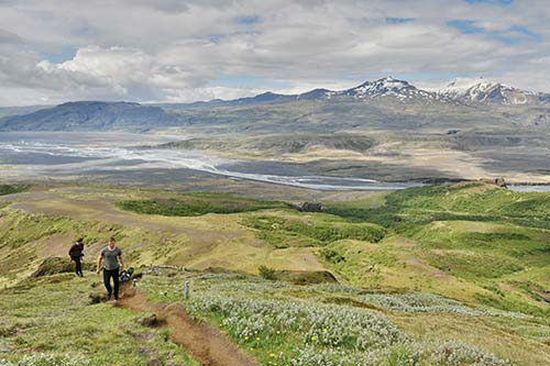
Hiking Tips: Most people hop off the bus at Húsadalur, hike from the Volcano Huts over Valahnúkur, descend to Langidalur, then return on the easy saddle trail back to Húsadalur. With more time, consider riding the bus all the way to Básar, hiking across the Krossá to Langidalur, then summiting Valahnúkur and descending to Húsadalur for your return bus at the Volcano Huts; you’ll miss the wooded saddle hike, but the variety gained by hiking across the river valley more than makes up for it. Gígjökull and Stakkholtsgjá are both fine hikes, but bus schedules can make it hard to combine them with others in the area. (They’re more practical if you’re taking a super-jeep tour or a private trip.)
▲▲Gígjökull—Volcano Split Rock (Easy)
This small side-valley, near the entrance of Þórsmörk, is an easy and scenic stop. You’ll see a looming glacial tongue and a gigantic rock that’s been neatly cleaved in half. This split rock—already slightly cracked before—was ripped wide open by the 2010 eruption of Eyjafjallajökull. Melted glacier water came pouring down Gígjökull, flooding this area and silting up what had been a dreamy glacier lagoon.
The glacier and split rock are easy to spot from afar. To get closer, take a relatively easy, brief, and rewarding hike (15 minutes each way). From the parking lot, you’ll scramble over a terrain that’s pebbly, then rocky. While not strenuous, the footing can be tricky, including stretches where you may have to hop along rocks in a stream.
If you’re on the bus, you likely won’t be given enough time here for the hike (save your energy for the biggies coming up soon). But smaller or private super-jeep tours enjoy stopping here.
▲▲▲Valahnúkur (Moderately Challenging with Spectacular Scenery)
The main reason to come to Þórsmörk is for this glorious hike, offering stunning views in every direction. But the trail makes you earn it: While the hike isn’t long (less than one mile from either valley to the summit), it’s extremely steep in stretches (with an elevation gain of about 900 feet). The footing varies—stone steps, wooden steps, gravel—but it’s mostly stable. You can hike to Valahnúkur from the Volcano Huts (Húsadalur) or from Langidalur. Either way, follow the well-marked Valahnúkur trail up, up, up, enjoying higher and higher views. Near the summit, the ladder-like trail has been known to cause vertigo—take plenty of breaks.
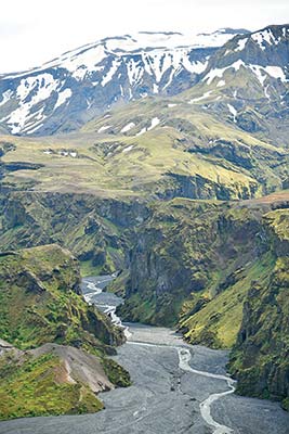
From the top, scan the horizon for the three glacier-topped volcanoes that surround Þórsmörk, the adjacent Goðaland range, and glacial valleys that fan out into the horizon. The smaller valley just to the right of the Krossá is the Hvanná. Look just above this, to the saddle of land between the two big glaciers (Eyjafjallajökull and Mýrdalsjökull); this is Fimmvörðuháls, where the first stage of the big 2010 Eyjafjallajökull eruption took place. A directional sign points out these and other distant landmarks. Figure about 1.5 hours to summit Valahnúkur and descend back down the other side.
▲Saddle Trail Between Húsadalur and Langidalur (Easy)
The easiest ascent over the Þórsmörk ridge connects two low-lying valleys: Langidalur (Long Valley) and Húsadalur (House Valley). The terrain is pretty but mostly wooded, without dramatic views. Hikers use this trail mainly for an easy return to the Volcano Huts after tackling Valahnúkur, but it’s also a nice option for those seeking an easier hike (figure 45 minutes or less, one-way). Along Húsadalur, among the jagged volcanic formations just above the Volcano Huts, a side trail leads to Snorraríki—a cave burrowed into a wall that’s carved with modern names and old runic inscriptions (to reach the cave itself, you’ll need to scale a wall with stone footholds).
▲Rocky Stroll Across the Krossá River (Easy)
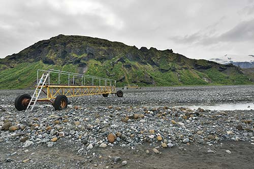
The Krossá river carves its way through a rocky landscape between Básar (at the base of the Goðaland ridge) and Langidalur (at the base of the Þórsmörk range). This is the same river you’ll crisscross on your way to and from this area, but the 30-minute hike across this valley gives you a closer look. As you walk across the desolate expanse, keep an eye out for two or three movable bridges, which are strategically placed to help hikers cross (marked with yellow arrows). The footing is uneven but walkable—a mix of sand, pebble, and ankle-twisting rock of every color.
▲▲Stakkholtsgjá Canyon Hike (Moderate)
This narrow valley, with walls up to 300 feet high, cuts a mossy mile-and-a-quarter deep into the cliff. Plan on 1.5 hours round-trip for this hike. While mostly level, the footing is uneven, and the canyon’s river is always in flux—you’ll likely have to step, or even jump or wade, across a swift current. Where the stream forks, bear left. The ever-narrowing canyon culminates at a cave-like enclosure with a gushing waterfall. For a closer look, you’ll have to scramble up some slippery rocks. Stakkholtsgjá is a good compromise for reasonably hardy hikers who don’t mind uneven footing and want a scenic walk, but aren’t up for the steepness of Valahnúkur. The real challenge is finding a way to do this hike if you’re getting around by bus. Buses stop here by request only—and you may not be able to catch a returning bus for many hours. Before getting off, clearly establish the return bus time with your driver.
SLEEPING AND EATING IN ÞÓRSMÖRK
Serious hikers enjoy settling in for a few days to explore Þórsmörk. Your options are the ¢-$$ Volcano Huts at Húsadalur, with a variety of private rooms, dorms, cottages, and camping (www.volcanohuts.com); the ¢ Skagfjörðsskáli hut, at Langidalur, with dorms, camping, and a private cottage (www.fi.is); and ¢ Básar, with dorms and camping across the valley from Skagfjörðsskáli in the Goðaland foothills (www.utivist.is/skalar/basar-a-godalandi).
Services are sparse in Þórsmörk. The only real restaurant is the $ cafeteria at the Volcano Huts. Bring a picnic to enjoy at your leisure—there are plenty of glorious viewpoints.