DARTMOOR
Windswept and desolate, Dartmoor is one of England’s best national parks and one of the few truly wild places you’ll find in this densely populated country. The open moors of Dartmoor sit on a vast granite plateau, and occasionally, bare granite peaks, called tors, break through the heather. Rising like lonesome watchtowers, these distinctive landmarks are the goal of popular hikes.
A well-planned walk through the moors rewards day hikers with vivid memories. Old stone-slab clapper bridges remind hikers that for thousands of years, humans have trod these same paths. The terrain is littered with the highest concentration of prehistoric monuments in the UK—and they’re lonely and awaiting your visit.
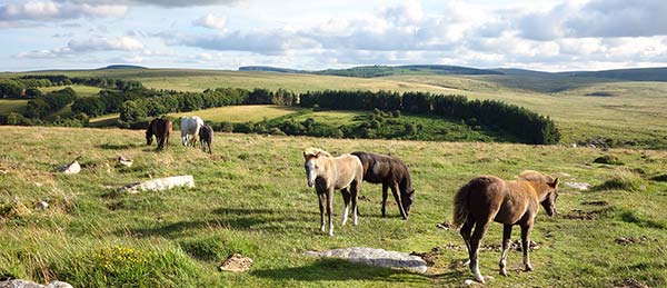
The iconic ponies of Dartmoor run wild. These ponies, whose ancestors were the working horses of local miners, are a hearty breed, known for their stamina. Today they’re beloved by hikers for the romance they bring to the otherwise stark terrain.
Great literary minds, perhaps inspired by all that mystery and prehistory, have been drawn to Dartmoor for centuries: Sir Arthur Conan Doyle (his masterpiece, The Hound of the Baskervilles, was set here), Agatha Christie (who wrote her first mystery novel here), Evelyn Waugh (who wrote Brideshead Revisited here) to name a few. Even filmmaker Steven Spielberg (whose movie War Horse was filmed here) was inspired by Dartmoor’s landscapes.
Dartmoor remains first and foremost the terrain of hikers. Here you can be alone with England’s history, jaded sheep, stately wild ponies, and seemingly endless moors. It’s also a moody place: At sunset on a clear evening, the gold-tinged heather and rolling hills lift one’s spirits, but on a gray and misty day, it’s foreboding—and if you listen hard enough, you might just hear the howl of the hound of the Baskervilles.
PLANNING YOUR TIME
Dartmoor works well as a stopover between Cornwall (see next chapter) and the rest of England. You can get a taste of Dartmoor with one overnight (after breakfast, do my Dartmoor Drive and/or visit Scorhill Stone Circle before moving on in the afternoon). But it really deserves at least one full day and two overnights to fully appreciate its majesty and mystery. This is one of those places where time slows down...and puts a crimp in an ambitious itinerary. The park website (www.dartmoor.gov.uk) has helpful planning information.
GETTING AROUND DARTMOOR
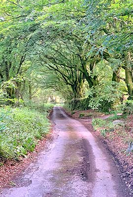
By Car: Drivers have Dartmoor by the tail—but a good map or GPS device is essential...as is a fair amount of courage. Dartmoor’s narrow lanes are the most challenging in England: barely as wide as a single car and often flanked by tall stone walls covered in greenery. Be patient and have confidence—as most roads are too narrow for two cars to easily pass, you’ll often have to pull up or reverse to the nearest wide spot in the road when encountering another car. Just follow the other driver’s lead, fold in your mirrors as needed, and wave a thank you. For driving in Dartmoor, rent the smallest car you can tolerate, and you’ll breathe easier. Secondary roads have less traffic on weekdays.
Most parking lots accept coins only; some have a minimum £3 charge—be prepared. The only places to buy gas on or near the moors are in Chagford and Bovey Tracey.
By Train: Though Dartmoor is tricky for visitors without a car, trains run daily between Exeter and Okehampton, at the northern tip of the park (£4.20, trains run hourly, 40 minutes from Okehampton to Exeter, +44 3457 000 125, http://dartmoorline.com). From Okehampton station, you can access several hiking trails and rent bikes.
By Bus: Bus connections are sparse on weekends and nearly nonexistent during the week (+44 871 200 2233, www.dartmoor.gov.uk or http://traveline.info).
During high season, Stagecoach’s Haytor Hoppa/#271 bus runs Saturdays only to cover the east side of Dartmoor (£5 hop-on, hop-off ticket, late May-mid-Sept, 4/day), looping from Newton Abbot’s train station to Bovey Tracey, up to Haytor and on to Widecombe-in-the-Moor and Hound Tor, before returning to Bovey Tracey and Newton Abbot. First Bus operates the Dartmoor Explorer hop-on, hop-off bus in July and August, starting in Exeter with stops in Moretonhampstead, Postbridge, and Two Bridges (£10, 4/day, www.firstbus.co.uk/adventures-bus/tickets). Two other bus routes from Exeter also connect to Dartmoor towns (Mon-Sat year-round, no buses Sun): Dartline #173 to Chagford and Moretonhampstead (4/day), and Country Bus #359 to Moretonhampstead (6/day).
Orientation to Dartmoor
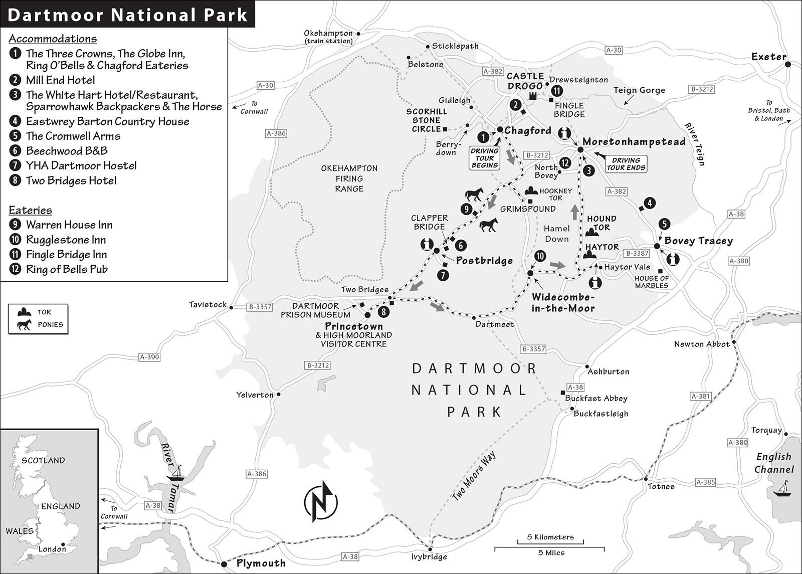
Dartmoor is located in Devon, England’s least densely populated but second-biggest county. Dartmoor National Park is vast (368 square miles), but I’ve focused on the most accessible chunk, at the northeastern end of the park between the A-30 and A-38 highways.
Throughout Dartmoor, there are more than 10,000 ancient monuments, all accessible to walkers. Park information offices are in Princetown, Postbridge, and Haytor (see “Tourist Information,” later). The small villages that encroach on the park are charming. Towns of reasonable size (including Chagford, Moretonhampstead, Bovey Tracey, and Widecombe) have parking lots (free or cheap—have coins handy) and WCs (generally free). Moretonhampstead and Bovey Tracey also have TIs.
Two pieces of gear are essential: good shoes (you’ll be slogging through mud and dodging wild-horse patties) and a detailed Ordnance Survey map. Roads and walking paths can be tricky to follow: While only two major roads cross the moor, there are dozens of lesser roads twisting through the countryside—it seems there are five different ways to get between any two points. The Ordnance Survey produces two good maps of the region. The 1:25,000 Dartmoor map (Explorer #OL28) is ideal for serious hikers, because it shows every ridge, feature, and landmark, but drivers may prefer the 1:50,000 map (called “Okehampton & North Dartmoor,” Landranger Map #191). Drivers also may find that GPS tends to lead them down narrow one-lane roads. Instead, stay on two-lane roads as much as possible to avoid stress; it’s smart to map out a route in advance rather than blindly trusting your device.
Safety Advice: Parts of the moors are used by the military for target practice. These areas are clearly shown on maps and marked by red flags when in use—but before going for a hike, always check with a park information office to ensure your route is OK. The British government also posts firing schedules online (search “Dartmoor Firing Times”).
Weather can change quickly here, so wear layers and be prepared for “four seasons in one day” (as locals say). Because Dartmoor is so vast and empty, and cell connections are so spotty, getting lost is a real risk—a good map and a compass, along with a phone with GPS, are essential if you’re going more than a short distance from your car.
Other dangers include ticks and adders (a poisonous snake with a black-and-white zigzag stripe).
TOURIST INFORMATION
Most of the bigger villages surrounding Dartmoor have TIs with inconsistent hours, but the main information center for the park is the High Moorland Visitor Centre in Princetown. In addition to hiking info, this office has an interactive exhibit on the history, wildlife, and “countryside code” for walking the moors (open year-round: July-Sept daily 10:00-17:00, rest of year until 15:00 or 16:00, Nov-Jan closed Mon-Tue; Tavistock Road, +44 1822 890 414, www.dartmoor.gov.uk). There are also good branches in Postbridge (at the big parking lot near the clapper bridge, hosts a small exhibit on Bronze Age Dartmoor; same hours as above, except Nov-Jan closed Thu-Fri; +44 1822 880 272) and by Haytor (on the B-3387 3 miles west of Bovey Tracey, same hours as above except Nov-Jan closed Mon-Wed; +44 1364 661 520).
At any of these offices, you can buy your Ordnance Survey map and pick up the free information-packed Enjoy Dartmoor guide (also downloadable online). These offices are the best source of advice on hikes or driving routes, and each one sells an illustrated booklet with suggestions for self-guided walks in that area. The Walks Around Haytor booklet, covering Haytor Rocks, Hound Tor, and other nearby destinations, comes with a fine foldout map and covers ancient, medieval, and early modern history. It lays out a circular eight-mile hike connecting landmarks with other neighboring sights. You can also download free, six-mile audio walks that start at each of the three park information centers (www.dartmoor.gov.uk; search for “audio walks”).
The TIs in Moretonhampstead (June-Sept daily 10:00-16:00, shorter hours off-season, closed Jan, New Street, +44 1647 440 043, www.visitmoretonhampstead.co.uk) and Bovey Tracey (see “Sights in Dartmoor,” later in this chapter) can also be helpful.
Guided Walks and Tours: Guided walks are offered by a local guiding collective called Moorland Guides (www.moorlandguides.co.uk). Tom Soby offers a range of walks and drives, including a popular one exploring the places featured in The Hound of the Baskervilles (4-hour private tours-£80, book 2 months in advance, +44 7591 803 763, tomstors@hotmail.com).
Dartmoor Drive
PONY, LAMB, AND MOOR JOYRIDE
This self-guided driving tour—worth ▲▲▲—is a convenient framework for your Dartmoor exploration. This route begins in Chagford and ends in nearby Moretonhampstead, but you can join or leave it wherever you like. The distances are short—the route is about 40 miles total—but the drive takes all day when you add in hikes and exploration. Linger at the desolate viewpoints you find most appealing, and don’t be afraid to venture off this plan for a walk to a secluded stone row or circle—there are many hidden gems in Dartmoor. If you’re in a rush, you can squeeze this drive into three hours: Skip the detours (such as Grimspound and Princetown), choose just one tor to climb, and grab lunch on the go.
• Begin in the village of...
▲Chagford
Perched on the edge of the moor, this tiny town is not only charming but actually feels like a real, normal slice of English life (www.visitchagford.com; park on the street for up to 2 hours or at the pay lot at the far end of town, past the church and Jubilee Hall—follow P signs). The small-town ambience here may make you feel like you’ve stepped into a time warp (or maybe a quaint BBC sitcom). Villages like this one, which was probably established in Saxon times, were built around Dartmoor as bases for the tin-mining industry. In 1305, Chagford became one of four Dartmoor stannary towns, where miners brought their tin to be weighed and duty paid. The eight-sided Market House in the village square (known as the “pepper pot”) is located on the site of the old stannary court/assayer’s office.
St. Michael’s Parish Church, at the upper end of town, mostly dates from the 15th century and is built from gray granite, the typical stone of the area. The hard rock is tough to work, so most buildings here are fairly simple. Inside, look in the pews for the needlepoint cushions, a few of which bear a tinner’s symbol: three rabbits in a circle, each seeming to have its own pair of ears, but sharing only three ears among them. An incident occurred here that is said to have inspired R. D. Blackmore’s Lorna Doone: A bride named Mary Whiddon was shot dead by a former suitor as she left the church during her wedding in 1641. More recently, the church is known for its effort to save its resident swifts by building special nesting boxes in the 800-year-old tower and playing a recording of their distinctive birdsong at dawn and dusk—peek in on the swift-cam to see what they’re up to.
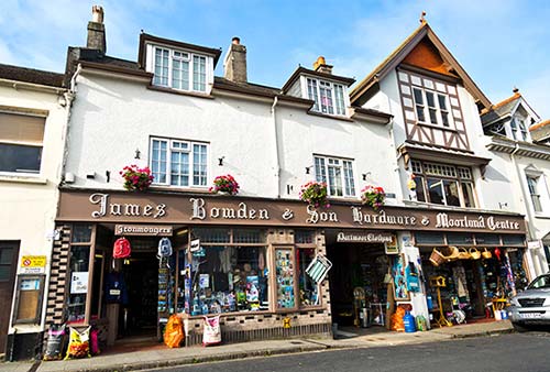
The little village square has all the essentials: bank, post office, small grocery store, pharmacy, butcher, delicatessen, and a few hardware shops that sell any hiking gear you might have forgotten (including Ordnance Survey maps). Go gawk inside Bowden’s hardware store and “Moorland Centre” to see how everything you could possibly ever need can be neatly crammed into one place. Don’t miss the glassed-in antique-hardware room way in the back and the loft full of rain gear (Tue-Sat 9:00-17:30, closed Sun-Mon). Fat Mouse Dairy sells ice-cream cones, interesting cheeses from the area, and clotted cream by the pound (Mon-Sat 9:00-18:00, closed Sun, shorter hours off-season).
• Hop in your car, drive past the church, and follow Postbridge signs directing you to the road south of Chagford (very skinny for a couple of miles), hit the B-3212, and turn right. Soon after you turn, you’ll cross some...
Cattle Grates
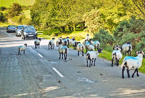
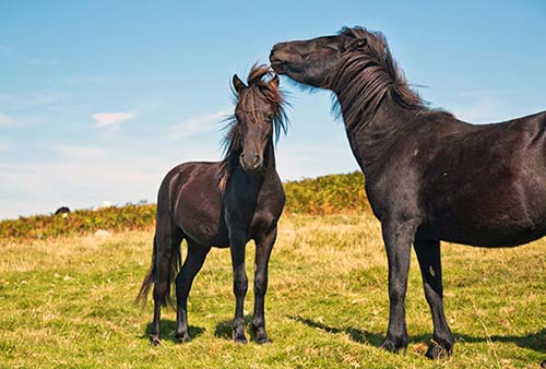
Welcome to wild-pony country. The rumble of your tires over cattle grates—which you’ll cross several times on our drive—tells you that you’ve entered an area without fences, where livestock of all kinds can roam freely. It’s also a reminder to slow down and watch the road closely, especially around blind corners—you may well find some animals sunning themselves in the middle of the road. I’ve had to lean on my horn several times to convince a dozing sheep to let me pass. As throughout England, you’ll see sheep grazing and fluffy little lambs bounding through the heather. But Dartmoor adds its own unique touch: famously “wild,” but remarkably tame, horses. (In fact, the horses are all owned by local farmers, who keep an eye on them as they graze the moors—some horses are branded.) Horses have wandered here for centuries, and the brown ones are probably the most closely related to the ancestral Dartmoor breed. The park discourages people from feeding or even approaching the horses—even if a horse readily approaches you, it might bite or kick without warning.
• After crossing the cattle grates, you’re really in the heart of...
The Moors
England’s green, bucolic landscape is occasionally interrupted by brown, scrubby moorlands like these. A moor is characterized by its relative lack of vegetation, save for high grasses and heather—a dull-brown shrub that thrives here. In late summer, the heather blooms a brilliant purple, contrasting with splashes of vibrant yellow gorse (closely related to Scotch broom). The long, undulating expanses of open land, almost unbroken by trees but scattered with long-forgotten prehistoric stone monuments, make Dartmoor feel even more mysterious than other English moors.
• On the left, you may notice the first of many tors—hilltop granite outcroppings—we’ll see on this trip. This one overlooks the evocative remains of a Bronze Age settlement. If you’re up for a hike, consider this optional detour to get a closer look: Turn left at the white and brown Widecombe/Grimspound sign, and follow the road for about a mile—keeping an eye on those hilltop rocks above you on the left. The road reaches a steep bend at a place where a mountain stream may trickle down the hill; look for a tiny, well-worn wooden sign on the left and a three-car pullout on the right. You can park and use the inconspicuous trailhead to begin a 10-minute climb up to...
Grimspound
As you face the hilltop pile of rocks called Hookney Tor, look right to the saddle between the two hills to find the huge, graceful outer ring of Grimspound. Dating from 2000 BC, this late Bronze Age settlement survived here for 800 years, with an outer boundary wall enclosing multiple stone roundhouses, or hut circles. In some, the tall stones flanking the entryway are still visible. The outer wall was probably designed to keep wild animals out or to pen livestock. Notice that the ring is designed to provide access to the stream. Running water was both useful and (archaeologists believe) spiritually important to prehistoric peoples. Well populated in ancient times, the moors are thought to have become unlivable about 1200 BC because of climate change, and settlements like these were abandoned. From the settlement, look across the valley; on the left side of the adjacent ridge (to the left of the stone rabbit fence that runs down to the valley), you’ll see the faint remains of hillside terraces, called lynchets, created by medieval farmers.
If you have time for a longer hike, consider huffing up to the top of Hookney Tor for a better view down on Grimspound and the surrounding hills. (A standing stone and a stone row are both faintly visible—to those with excellent eyesight—on the top of the ridge across the valley.) The flat hilltop above Grimspound (Hamel Down) was covered with poles during World War II, to prevent German gliders from landing there.
• Back in your car, backtrack to the main road, and turn left to continue south. After about a mile, on the left, just before the big parking lot, look for the worn and weathered stub of a...
Celtic Cross
All along the road, look for tall stone crosses like this one. These marked the way for villagers to cross the moor. Many of these began life as prehistoric pagan pillars and were carved into crosses later, after Christianization.
• Soon after the cross, on the right, you’ll see the...
Warren House Inn
Named for a warrener (rabbit raiser) who fed bunnies to hungry miners, this pub comes with a fun history. This site has reputedly been occupied by a travelers’ rest stop for more than 900 years. In 1845, a pub across the road was falling down from disrepair, so this “new” structure was built. Supposedly embers from the old fire were used to light the fire in the new building—which has burned ever since. While the story is questionable, the $$ food here is good—specializing in (of course) rabbit pie, as well as steak-and-ale pie. The glorious moorside seating, at picnic benches out front and across the road, make it an enticing stop for a meal or drink. If it’s chilly, take advantage of the cozy interior, with that legendary fireplace still smoldering (daily, off-season closed for dinner Mon-Tue, +44 1822 880 208).
• There’s a lot moor to see (sorry), so let’s keep moving. Carry on along the same road into the town of...
Postbridge
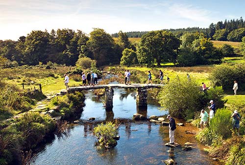
This functional village comes with one of Dartmoor’s classic views. As you cross the bridge in the heart of town, on the left you’ll see an ancient bridge parallel to the road. Bridges like this one—essentially stone slabs resting on piled-up stones—dot the moor. Called clapper bridges, they date from the Middle Ages, if not earlier. For a closer look, pull over at the big parking lot on the right soon after the bridge, near the handy and very helpful national park office. If you have time, pick up their booklet for walks and consider a hike—Postbridge is a good base for moor walks.
• Continue down to the village of Two Bridges, where you hit the B-3357. Our route turns left (east, follow sign to Dartmeet). But you could consider detouring to the right (west) to the town of Princetown, with its High Moorland Visitor Centre (see “Tourist Information,” earlier). Princetown is also home to a historic high-security prison that held French prisoners during the Napoleonic Wars, and American POWs during the War of 1812; today it has a museum (see “Sights in Dartmoor,” later). Those same prisoners built the town’s church—which flies the French and American flags inside as a tribute.
Heading east on the B-3357, you’ll cross more cattle grates and enjoy moor scenery. Soon the straightforward highway disappears, and you’ll have to use narrower back roads to reach our next stop. You’ll feel lost, but use GPS or your map and track signs closely: Leaving the moor, cut through the forest and carry on straight through Dartmeet (worth a stop to see its clapper bridge and stroll up the stream), then veer uphill toward (but not all the way to) Ashburton. You’ll go back up and down another mini moor; at this point, watch for the turnoff on the left toward Sherril and Babeny; once on this road, continue straight (skipping the second Sherril/Babeny turnoff) into the village of Ponsworthy. From here signs direct you to our next stop (with a parking lot near the church).
▲Widecombe-in-the-Moor
Set in the center of the rolling hills, this adorable but often shopper-choked village is a scenic stop—and feels crowded after a drive on the empty moor. There’s usually a farmers market on the fourth Saturday of the month, and generally a Thursday craft market during the summer at the 1537 Church House (April-Nov, www.widecombe-in-the-moor.com). Stroll through the tranquil churchyard, with views of hilltop tors on the horizon above, and dip into the Church of St. Pancras.
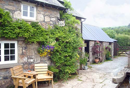
If you’re ready for a meal, there are a few decent café options. For a real treat, drive on (turning right at the sign by the Church House) down the country road to the $$ Rugglestone Inn—which is more likely to have local farmers than tourists drinking a pint. They serve up heaping plates of good, hearty food (meat and fish pies are the favorite)—but watch out for the high-powered local cider. Hunker down in the wonderfully claustrophobic interior or stroll across the stream to the delightful garden (food served daily 12:00-14:00 & 17:30-20:00, +44 1364 621 327, www.rugglestoneinn.co.uk).
• Leave Widecombe, following signs for Bovey Tracey and enjoying the sky-high views. (On a clear day, you can see all the way to the English Channel.) Now we’ll take a look at two of the better-known tors of Dartmoor. If you need to choose just one: Haytor offers better views but is a more difficult climb; Hound Tor is the more impressive formation.
On the Bovey Tracey road, you’ll spot a turnoff on the left toward Hound Tor and Merton, which we’ll take later. To see Haytor, continue 1.5 miles farther on—you’ll spot the rocky hilltop above you on the left. Park in the giant lot on the right (after a smaller one on the left) and hike 15 minutes up to the grand...
▲Haytor
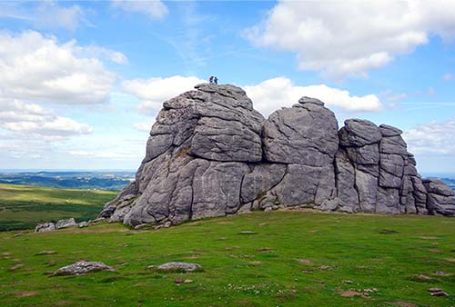
Dartmoor sits up on a granite plateau, and occasionally bare granite “peaks” poke up through the heather. (These are the crumbling craters of long-extinct volcanoes—covered by dirt and sediment that has since eroded away.) Like lonesome watchtowers looming above the barren landscape, these tors are Dartmoor’s most distinctive landmarks—and Haytor is the most famous and popular, thanks to its easy access, great king-of-the-mountain feeling, and excellent vantage point for panoramic views. Tors look like piles of boulders that you can imagine might have been dragged and dropped on hilltops by prehistoric developers, but they’re all natural. This area is divided into two parts: Haytor itself, and the adjacent Haytor Rocks. (The TI’s little hiking guide describes a fine circular hike connecting Haytor Rocks and Hound Tor with a nearby quarry and a stone “tramway” from 1820.)
• Yet another national park information office is on this same road, a minute beyond the parking lot. And if you’d like to detour into the town of Bovey Tracey (described under “Sights in Dartmoor,” later), now’s the time—it’s 10 minutes away on the B-3387, down in the valley.
To continue our loop, backtrack to the Hound Tor/Merton turnoff (it’s the next turnoff), which you’ll now follow north through the moors. Soon you’ll see another tor ahead and on the right. When you get to the little fork, follow the P signs to the right and park to walk up to...
▲▲Hound Tor
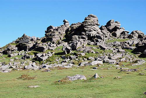
Perhaps the most striking tor in Dartmoor, and the inspiration for the Sherlock Holmes story The Hound of the Baskervilles, this mighty clump of rocks impresses. According to legend, this stand of stones was once a pack of hunting dogs that had disrupted a witches’ coven. As a punishment, the pooches were petrified. (The hunter who owned the dogs was turned into the nearby tor called Bowerman’s Nose, about a mile north of here.) Hike up and scramble over the many levels. In the valley beyond this ridge are the faint remains of some old Devon longhouses. These were situated at a gentle angle, with animals in the lower part and people in the upper part—liquids and other waste would run downhill, while the heat generated by the livestock would warm its owners above.
• Our tour is nearly finished. From the Hound Tor parking lot, backtrack a few yards to the little fork and turn right, following signs to the charming town of Moretonhampstead (M’hampstead on signs). You’ll find parking and free WCs on your left as you enter town (on Court Street). The town’s tiny, thatched center is a busy traffic crossroads, with a few pubs and restaurants (including the recommended pub The Horse), a Co-op grocery store, a pharmacy, a bakery, and a hardware store. What else could you need?
Our drive is finished...but there’s plenty more of Dartmoor to explore. If you still have daylight left, consider heading north out of Moretonhampstead on the A-382 until the turnoff (to the right) for Drewsteignton and the Fingle Bridge; or head back through Chagford and venture to the Scorhill Stone Circle (both described under “Sights in Dartmoor,” next).
Sights in Dartmoor
▲Walks on the Moors
Before you start walking, pick up an Ordnance Survey map (at any local shop or TI) or download a hiking app (Devon Walks is user friendly). The Princetown TI also has a map with suggestions for routes through the moors. Postbridge, in the heart of the moorlands, is a fine launch pad for good walks, and has a park information center that can suggest many well-outlined routes. Other good walking bases include Belstone in the north (for rugged scenery) and Ivybridge in the south (more forested). You can go almost anywhere—except the firing ranges. These are technically open for walking when not in use (you’ll see red flags if they’re closed). For more pointers, read “Orientation to Dartmoor,” earlier.
Here are a few ideas for popular, easy-to-moderate, two- to four-hour hikes in the region. Before attempting any of these, get details (and ideally maps) from a local TI or park office:
From Scorhill Stone Circle (described next), you can continue through Scorhill Down to the river, where you’ll see a tolmen (a doughnut-shaped stone), then proceed through Chagford Common before hooking back up past Kestor Rock toward your car.
From Postbridge, consider the hike up to Bellever Tor, then circle around to the youth hostel and back to the bridge.
From Haytor’s park information office, circle around the base of Haytor Down to the village of Leighton, then hike back along the road.
From Grimspound, the Bronze Age settlement described on the Dartmoor Drive, you can hike up to Hameldown tor and along the summit of Hamel Down, then down into the valley and back to your car.
▲▲Scorhill Stone Circle
Hundreds of Neolithic ruins dot the landscape of Dartmoor, but the Scorhill (SCO-rill) Stone Circle near Gidleigh may be the best. Stonehenge, the iconic stone circle, is much bigger—but it’s also packed with crowds. Tranquil, forgotten Scorhill is yours alone—the way a stone circle should be. As it comes with a scenic stroll across a moor, it’s a great sampling of what Dartmoor is all about—as much about the journey as about the destination.
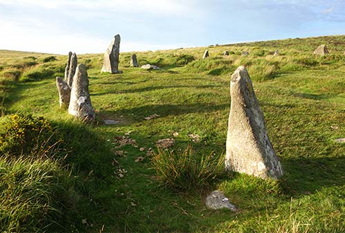
Once there, you’ll be alone with the heather, broom, ancient history, and often, sheep and wild ponies. Enjoying the solitude at the circle, scan the horizon, noticing other formations all around you—some natural tors, others likely man-made like this one. Places like Scorhill are a rare case in our modern world where we simply don’t know the who, what, why, or how.
Getting There: The trailhead, about a 15-minute drive west of Chagford, can be tricky to find. From Chagford, follow signs to Gidleigh—you’ll drive west out of town, bear right (uphill) at the fork, then turn right at the next intersection; from there, cross over the very narrow bridge, then turn left to go through Murchington. Proceed straight, going up and down the hills, following the same off-the-beaten-path road through the mossy stone hamlet of Berrydown, until you dead-end at a little parking lot (if in doubt, follow signs for Scorhill). From there, walk through the gate and hike about 15 minutes straight ahead up and over the moor (with long stone fences on either side of you, which gradually widen—part of a system shepherds designed to funnel their sheep without the sheep realizing it). After cresting the hill (with 360-degree views), head down into the gentle valley and look for the circle below. When the wide, well-trod path through the heather forks, angle right. It’s a good idea to glance back every so often to establish a few landmarks for your return.
▲Teign Gorge and Fingle Bridge
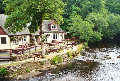
In the town of Drewsteignton, a narrow road leads down into the Teign River Valley (from the B-3219, watch for the easy-to-miss Fingle Bridge signs to the right). At the end of the road is the out-of-the-way but understandably popular $$ Fingle Bridge Inn, a pub set along a river and a picturesque old bridge. The food is good and reasonably priced, with daily specials and a hearty ploughman’s lunch of open-face sandwiches. While the interior is cozy, on a nice day it can’t match the delightful riverside picnic tables (lunch daily, dinner Wed-Sat, +44 1647 281 287, www.finglebridgeinn.co.uk). The bridge is a popular spot for weddings and fly-fishing. The trail across the road makes for an excellent post-meal amble along the river.
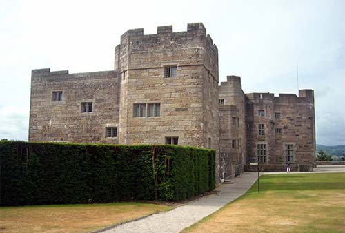
Castle Drogo
Just up the road from the Teign Gorge, you’ll come across this elaborate country house—complete with a circular croquet lawn (ask about borrowing balls and mallets at the ticket desk) and formal gardens. Drogo has the honor of being the last castle built in England, finished in 1930. Come here only if this is your best chance to see a noble estate.
Cost and Hours: £14; daily 10:30-16:30, grounds and visitors center open at 10:00, shorter hours off-season, closed late Dec-mid-Feb; café, +44 1647 433 306, www.nationaltrust.org.uk/castledrogo. Some trails on the estate lead down to Fingle Bridge.
Dartmoor Prison Museum
It makes sense that a prison would be set upon the moors. To Victorian-age Londoners, this rugged and distant land must have felt like Siberia. Built in the early 1800s to house French military prisoners captured during the Napoleonic Wars (along with some American POWs from the War of 1812), Dartmoor Prison now incarcerates civilian criminals. Notorious for housing some of the most unsavory convicts alive (sort of a British San Quentin), the prison was also used briefly in 1917 to hold conscientious objectors who refused to join in World War I. The museum, located in the former dairy across the street from the prison, is well laid out and features historical exhibits and artifacts from shackles to homemade items crafted by inmates.
Cost and Hours: £4; daily 9:30-16:30, Fri and Sun until 16:00; just north of Princetown on the B-3357/Tavistock Road, +44 1822 322 130, www.dartmoor-prison.co.uk.
Bovey Tracey
This town (pronounced “Buvvy Tracy”) on the southeast side of Dartmoor National Park is too big to be cute (pop. 7,000), but it does offer a few modest indoor options when the rains chase you off the moors (just 10 minutes’ drive east of Haytor on the B-3387). The TI is located on the main street at the main parking lot on the right as you drive into town (Tue and Thu 10:00-16:00, Fri-Sat until 13:00, closed Sun-Mon and Wed, sporadic hours off-season, Station Road, +44 1626 832 047, www.boveytracey.gov.uk).
Bovey Tracey, a pottery town until the 1950s, is becoming known as a center for fine crafts. Clay was quarried nearby, and Josiah Wedgwood even nosed around here when deciding where to locate his pottery factory (he later chose Staffordshire). Make Southwest, an appealing gallery/museum and shop in a restored riverside mill downtown, showcases items by artists from southwest England (free, Tue-Sat 10:00-17:00, closed Sun-Mon, café, immediately after crossing the river on Station Road, +44 1626 832 223, https://makesouthwest.org.uk).
The House of Marbles, on the outskirts of town, is goofy enough that you might want to visit. It’s basically a giant gift shop inside a historic pottery with some interesting glassmaking displays. Check out the marble museum displaying antique marbles, ones made of odd materials, and fun, kinetic wire marble mazes (upstairs, the largest run takes up an entire wall and uses snooker balls). The place is also home of the Teign Valley Glass Studios, where you can watch artisans creating contemporary glassware (free, artists in action generally 11:00-15:00). Outside in the courtyard, surrounded by café tables, are old, circa-1900 “muffle” kilns (signs describe their history). In the gift shop, kids of all ages will love digging through the giant bins of multicolored marbles (free, Mon-Sat 9:00-17:00, Sun from 10:00, café, kids’ play area, about 1.5 miles south of town toward Newton Abbot just off the A-382, at The Old Pottery on Pottery Road, +44 1626 835 358, www.houseofmarbles.com).
NEAR DARTMOOR
▲Exeter Cathedral
The nearest large city to Dartmoor is Exeter, a pleasant and bustling university city of 120,000 (about 15 miles—a half-hour drive—east of the moor). Exeter’s claim to fame is its beautiful cathedral, which sits on a charming green. With a Norman core later embellished in Decorated Gothic style, the cathedral could be worth a stop if you’re passing through Exeter and have time to spare. Highlights of the grand interior include the ribbed vaulting; 400 colorful “bosses” (decorations at the intersection of vaulting spines, including the famous Becket Boss, showing the execution of Thomas Becket); the unique minstrels’ gallery (more commonly seen in palaces than churches); the colorful astronomical clock; and the quire, with its 50 fold-down, carved wooden seats called misericords.
Cost and Hours: £5, includes audioguide, £7.50 one-hour docent-led tour, look for discount coupon in Visit Exeter brochure, open to tourists Mon-Sat 10:30-16:30, Sun 11:30-15:00, longer hours and free for worshippers, +44 1392 285 983, www.exeter-cathedral.org.uk.
Sleeping in Dartmoor
Befitting such an atmospheric destination, accommodations in Dartmoor tend to be quirkier than the English norm. Sleeping here really feels like “going local.” Given the confusing spaghetti of back roads, it’s smart to call ahead for precise arrival instructions.
IN AND NEAR CHAGFORD
Along Chagford’s main street, several pubs rent rooms upstairs.
$$$ The Three Crowns is trying to bring contemporary class to this traditional town, with 21 modern rooms across the street from the churchyard. Weekends can be noisier at this functioning pub (High Street, +44 1647 433 444, www.threecrowns-chagford.co.uk). This is also a good place to eat (see “Eating in Dartmoor,” later).
$$$ Mill End Hotel, five minutes outside Chagford on the banks of the Teign River, is a country oasis with a peaceful garden and expansive grounds. Each of its 21 individually decorated rooms is contemporary and comfortable (family room, on A-382, +44 1647 432 282, https://millendhotel.com, info@millendhotel.com).
$$ The Globe Inn, with seven decent rooms, is a lesser value (family room, 9 High Street, +44 1647 433 485, www.theglobeinnchagford.co.uk, graham@theglobeinnchagford.co.uk, Graham and Mary). They’re also open for $$ meals (daily).
$$ Ring O’Bells, an old-school pub, has four simple but comfortable rooms that are worth considering if other options are booked (44 The Square, +44 1647 432 466, www.ringobellschagford.co.uk, info@ringobellschagford.co.uk).
IN MORETONHAMPSTEAD
Moretonhampstead—larger and less quaint than Chagford or Widecombe-in-the-Moor—is a handy home base with its own share of half-timbered appeal.
$$ The White Hart Hotel, which also hosts one of my recommended restaurants, rents 17 clean and modern rooms that lack character but are comfortable (The Square, +44 1647 440 500, www.whitehartdartmoor.co.uk, enquiries@whitehartdartmoor.co.uk).
¢ Sparrowhawk Backpackers, with an easygoing hipster vibe, rents cheap beds in the Moretonhampstead town center, in the light-filled loft of a restored stone stable (private and family rooms, no breakfast; 45 Ford Street, no sign—to find the courtyard entrance, pass through the alley next to the house and push hard on the wooden door; +44 1647 440 318, www.sparrowhawkbackpackers.co.uk, ali@sparrowhawkbackpackers.co.uk, Alison).
IN AND NEAR BOVEY TRACEY
Sleep here if you want to be close to a real town on the edge of the national park rather than the rustic villages inside Dartmoor.
$$$ Eastwrey Barton Country House is set on a terraced lawn halfway up the side of the Wray Valley between Moretonhampstead and Bovey Tracey. It has four warm and spacious rooms in a restored Georgian country house (countryside views, several nice lounges and an inviting garden, on the A-382 near Lustleigh, +44 1647 277 274, www.eastwreybarton.co.uk, info@eastwreybarton.co.uk).
$ The Cromwell Arms, a 17th-century coaching inn right in the middle of Bovey Tracey, has 14 simple, comfortable rooms and is a good option if other listings are full (family room, minimum 2-night stay on weekends, no breakfast, Fore Street, +44 1626 833 473, www.thecromwellarms.co.uk, info@thecromwellarms.co.uk, Phil and Kellie). The pub serves good $$$ meals in a traditional atmosphere (closed Mon-Tue).
NEAR POSTBRIDGE
Postbridge—more a wide spot in the road than a village—is a popular springboard for hikes. While there’s not much here beyond a pub, a TI, and a gift shop, there are plenty of services in Princetown, about a 15-minute drive south.
$$ Beechwood B&B, right at the entrance to Postbridge (as you approach from Chagford), is energetically run by Sarah and Ian. This cozy guesthouse has five rooms, a comfy lounge, a fine garden, and a glassed-in breakfast area (family room, free parking, Postbridge, +44 1822 880 332, www.beechwood-dartmoor.co.uk, enquiries@beechwood-dartmoor.co.uk).
¢ YHA Dartmoor on the moors is a simple, institutional hostel, but it comes with an impressive wildlife area out front so you can learn about the local terrain (private rooms available, breakfast extra, dinner available, open all year, reception open 8:00-10:00 & 17:00-21:00, free parking, kids’ game room, +44 345 371 9622, www.yha.org.uk, dartmoor@yha.org.uk). It’s about a mile south of Postbridge, well signed from the main road.
$$ Between Postbridge and Princeton, the creaky Two Bridges Hotel has been a welcome retreat for weary travelers since its days as an 18th-century coaching inn. Today, its 32 old-fashioned rooms and cozy fireplace offer a relaxing finish to a day on the moors (free parking, Two Bridges, +44 1822 892 300, www.twobridges.co.uk, reception@twobridges.co.uk).
Eating in Dartmoor
Dartmoor has a surprising array of good-quality eateries—including a few destination restaurants that charge big prices to match their big reputations. I’ve focused my listings on pubs with good food and located in charming villages or rustic countryside settings. Note that three of my favorites, all $$, are described earlier in this chapter: Warren House Inn, perched atop a moor south of Chagford; Rugglestone Inn, just outside the village of Widecombe-in-the-Moor; and the Fingle Bridge Inn, in the Teign Gorge.
IN AND NEAR CHAGFORD
In the charming town of Chagford, the main square is lined with practical eateries—both quick sandwich places and more traditional pub-like spots for dinner.
$$$ The Three Crowns, the best of the many pubs lining the main drag, is classy and modern, serving well-presented dishes more elegant than pub grub and with a respect for tradition. For seating, you have several options: traditional pub up front, modern glassed-in courtyard farther back, open-air interior courtyard, or a few outdoor tables (daily, High Street, +44 1647 433 444).
$$ The Globe Inn offers the most classic pub scene in town, serving in three zones—the bar, the bar’s lounge, and a classier restaurant. They are proud of their meat pies and fish-and-chips (daily, 9 High Street, +44 1647 433 485).
$$ Chagford Inn puts a modern spin on traditional pub meals, with chic dishes that are as relaxed as their dining room. Owners Ollie and Jordan present a rotating gastropub menu emphasizing locally sourced ingredients (Tue-Sat lunch and dinner, Sun lunch only, closed Mon, 7 Mill Street, +44 1647 433 109, www.thechagfordinn.co.uk. They also rent three $$ basic rooms upstairs, no breakfast).
$ Blacks Delicatessen is the perfect place to grab a quick lunch. Peruse the options—quiches, pies, pasties, paninis, and soups—in their display case, and consider supplementing your choice with their carefully selected grocery items. You can sit out on the main square or—better yet—head for the hidden outdoor tables tucked behind the deli, in the churchyard around back (Mon-Sat 8:00-14:00, closed Sun, 28 The Square, +44 1647 433 535).
$$ The Birdcage is good for a coffee break or lunch stop. It has a cozy, woody interior facing the square (daily 9:00-15:00, 11 The Square, +44 1647 433 883).
IN AND NEAR MORETONHAMPSTEAD
$$$ The Horse, with welcoming, lively decor and a well-respected chef, specializes in tasty, crispy wood-fired pizzas, along with Mediterranean dishes and traditional pub fare. You can sit in the cozy and convivial pub up front, or a few steps down in the quieter, more modern dining room (Wed-Sat lunch and dinner, Tue dinner only, closed Sun-Mon, reservations recommended on weekends, 7 George Street, +44 1647 440 242, http://thehorsedartmoor.co.uk).
In addition to The Horse, Moretonhampstead has two spit-and-sawdust pubs offering affordable food and drink, plus the upscale (almost pretentious) $$$ White Hart Restaurant, with a pleasantly traditional, spacious hunting-lodge feel (daily, The Square, +44 1647 440 500, www.whitehartdartmoor.co.uk; also has rooms for rent—see “Sleeping in Dartmoor,” earlier).
In North Bovey: This charming village—just a mile and a half (down narrow country lanes) from Moretonhampstead—has a triangular village green, more than its share of idyllic thatch, and a fine pub: $$$ Ring of Bells fills a 13th-century building with atmosphere, happy eaters, and good food. Choose between the various indoor dining spaces, or head out to the delightful yard, surrounded by thatched homes (Mon-Sat lunch and dinner, Sun lunch only, +44 1647 440 375). They also have five $$ rooms upstairs (https://eversfieldorganic.co.uk/pages/ring-of-bells [URL inactive]).