Eating in Arromanches
You’ll find cafés, crêperies, and shops selling sandwiches to go (ideal for beachfront picnics). The bakery next to the recommended Arromanches Militaria store makes good sandwiches, quiches, and tasty pastries. Many restaurants line Rue Maréchal Joffe, the bustling pedestrian zone a block inland. Here are three reliable choices:
$$ Hôtel de la Marine allows you to dine or drink in style—and with good-quality cuisine—right on the water (ideal outdoor seating for a drink in nice weather, daily).
$ La Petite Plage gets good reviews for the quality of its café fare (daily, 23 Rue Maréchal Joffre, + 33 2 22 31 32).
$ Les P’tites Assiettes is an inexpensive bistro serving good pizza, salads, and plats, with seating inside and out. It’s a few blocks up from the water at the Hôtel le Mulberry (daily, see “Sleeping in Arromanches,” earlier).
Arromanches Connections
From Arromanches by Bus to: Bayeux (bus #121, 5/day in summer; 3/day Mon-Sat and none on Sun in off-season), Juno Beach (bus #121, 20 minutes, www.nomadcar14.fr [URL inactive]). The bus stop is near the main post office, four long blocks above the sea (the stop for Bayeux is on the sea side of the street; the stop for Juno Beach is on the post office side).
American D-Day Sites
The American sector, stretching west of Arromanches, is divided between Omaha and Utah beaches. Omaha Beach starts just a few miles west of Arromanches and features the most dramatic landing sectors. For Americans, this is the most important D-Day sight. Utah Beach and the American Airborne sector (think paratroopers), while farther away, are very well presented and were equally essential to the ultimate success of the Normandy invasion.
Omaha Beach
Omaha Beach is the landing zone most familiar to Americans. This well-defended stretch was where US troops suffered their greatest losses. Going west from Arromanches, I’ve listed four powerful stops (and a few lesser ones): the massive German gun battery at Longues-sur-Mer, the American Cemetery, Omaha Beach itself (at Vierville-sur-Mer, the best stop on the beach), and Pointe du Hoc.
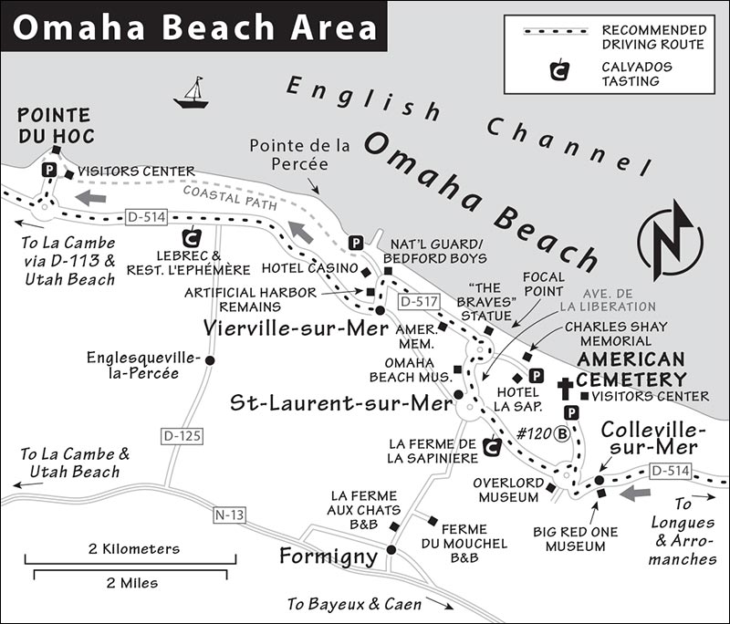
• The D-514 coastal road links to all the sights in this section—just keep heading west. Allow about 1.5 hours of round-trip driving time to connect these sights from Bayeux, plus whatever time you spend at each stop.
▲Longues-sur-Mer Gun Battery
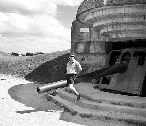
Four German casemates (three with guns intact)—built to guard against seaborne attacks—hunker down at the end of a country road, past a bunker-like visitors center. The guns, 300 yards inland, were arranged in a semicircle to maximize the firing range east and west, and are the only original coastal artillery guns remaining in place in the D-Day region. (Much was scrapped after the war, long before people thought of tourism.) This battery, staffed by 194 German soldiers, was more heavily defended than the better-known Pointe du Hoc. The Longues-sur-Mer Battery was a critical link in Hitler’s Atlantic Wall defense, a network of more than 15,000 defensive structures stretching from Norway to the Pyrenees. These guns could hit targets up to 12 miles away with relatively sharp accuracy if linked to good target information. The Allies had to take them out and fast, which is exactly what they did—the site was captured on June 7. Well done.
Cost and Hours: The site is free and always open. The visitors center sells a helpful €6 booklet and may offer guided tours to the site for a small fee (April-Oct daily 10:00-13:00 & 14:00-18:00, +33 2 31 21 46 87, https://bayeux-bessin-tourisme.com).
Getting There: The site is 10 minutes west of Arromanches off D-514 on Rue de la Mer (D-104). Follow Port-en-Bessin signs from Arromanches; once in Longues-sur-Mer, turn right at the town’s only traffic light and follow Batterie signs to the free and easy parking lot (with WC).
Visiting the Battery: Walk in a clockwise circle, seeing the inland gun bunkers first and then the command bunker closer to the bluff. Inspect the third bunker you pass. It took seven soldiers to manage each gun, which could be loaded and fired six times per minute (the shells weighed 40 pounds). Wander in and make a sound—the echo is palpable. Now imagine the noise that huge gun would make—six times per minute. Climbing behind the bunker, find the hooks that secured the camouflage netting that protected the bunker from Allied bombers.
Head down the path toward the sea, passing healthy crops (imagine the farmer’s challenge converting battlefields back to agriculture), until you reach the lone observation bunker hanging over the cliffs. This was designed to direct the firing; field telephones connected the observation bunker to the gun batteries by underground wires. You’ll want a light to enter the bunker, where you can face the sea to imagine the strategic view over the channel (now blocked by vegetation). From here you can walk east along the glorious Sentier du Littoral (coastal path) to see bits of Arromanches’ artificial harbor in the distance. Then follow the small road back to your car. It’s a 10-minute walk on the same road (opposite direction) down to the beach.
• Continue west on D-514, passing two small sights of note—Port-en-Bessin and the Big Red One Museum—before arriving at the American Cemetery.
Near Longues-sur-Mer
Port-en-Bessin
This sleepy-sweet fishing port west of Longues-sur-Mer has a historic harbor, harborfront cafés, a small grocery store, and easy, free parking. Drive to the end of the village, cross the short bridge to the right, and park. While the old harbor was too small to be of use during the invasion, this was the terminus of PLUTO (Pipe Line Under the Ocean), an 80-mile-long underwater fuel line from England. This (and an American version that terminated at Ste-Honorine, one town over) kept the war machine going after the Normandy toehold was established. Don’t cross the bridge back, rather take the road to the left, along on the opposite side of the harbor you came in on, which leads back to the main road.
Big Red One Museum
In humble Colleville-sur-Mer, this quirky museum is a small roadside warehouse crammed with D-Day artifacts. It’s also a labor of love—one of many such small D-Day museums in the area—and the life’s work of charming Pierre, who for 30 years has been scavenging and gathering D-Day gear—and he is still finding good stuff (ask about his latest find). “Big Red One” refers to the nickname of the 1st Infantry Division, the US Army troops in the first wave (with the 29th Infantry Division) to assault Omaha Beach. Pierre is happy to show visitors around—his passion for his collection adds a personal dimension to your D-Day experience. Near the museum, the main street of little Colleville-sur-Mer is lined with WWII photos.
Cost and Hours: €6, June-Aug daily 10:00-19:00, spring and fall Wed-Mon 10:00-12:00 & 14:00-18:00, closed in winter, Le Bray, Colleville-sur-Mer, +33 2 31 21 53 81. Pierre also leads tours of Omaha Beach (3 hours, €80/person).
▲▲▲WWII Normandy American Cemetery and Memorial
The American Cemetery is a pilgrimage site for Americans visiting Normandy. Crowning a bluff just above Omaha Beach, 9,386 brilliant white, marble tombstones honor and remember the Americans who gave their lives on the beaches below to free Europe. France has given the US permanent free use of this 172-acre site, which is immaculately maintained by the American Battle Monuments Commission.
A well-done visitors center prepares you for your visit. Plan to spend at least 1.5 hours at the cemetery. If you come late in the day, a moving flag ceremony takes place an hour before closing at the main flagpole—it’s worth planning around.
Cost and Hours: Free, daily 9:00-18:00, mid-Sept-mid-April until 17:00, +33 2 31 51 62 00, www.abmc.gov/normandy.
Tours and Services: Guided 45-minute tours are offered a few times a day most of the year (normally at 11:00 and 14:00, call ahead to confirm times, tours start from the bluff overlooking Omaha Beach— described below). A WC is in the basement of the visitors center.
Getting There: The cemetery is just outside Colleville-sur-Mer, a 30-minute drive northwest of Bayeux. Follow signs on D-514 toward Colleville-sur-Mer then find signs leading to the cemetery (plenty of free parking).
Visiting the Cemetery
From the parking lot, stroll in a counterclockwise circle through the lovingly tended, parklike grounds, making four stops: at the visitors center, the bluff overlooking Omaha Beach, memorials to the fallen and the missing, and finally the cemetery itself.
Visitors Center: The low-slung building is mostly underground. After you enter, you’ll see computer terminals providing access to a database containing the Roll of Honor—the name and story of each US service member whose remains lie in Europe. Out the far window, a rectangular pond points to the infinite sea.
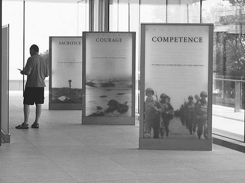
The exhibit downstairs does more than recount the battle. It humanizes those who fought and died, and are now buried, here. First, find a seat in the large theater playing a touching 16-minute film (On Their Shoulders) that highlights the lives of several service members who lie at rest here (shown on the half-hour, you can enter late). From here, worthwhile exhibits and more videos (one includes an interview with Dwight Eisenhower by Walter Cronkite) tell the stories of brave individuals who gave their lives to liberate people they could not know and shows the few possessions they left behind (about 25,000 Americans died in the battle for Normandy).
A lineup of informational displays on the left provides a worthwhile and succinct overview of key events from September 1939 to June 5, 1944. Starting with June 6, 1944, the exhibits present the progress of the landings in three-hour increments. Omaha Beach was secured within eight hours of the landings; within 24 hours it was safe to jump off your landing vehicle and slog onto the shore. Incredible.
You’ll exit the visitors center through the Sacrifice Gallery, with photos and bios of several individuals buried here, as well as those of some survivors. A voice reads the names of each person interred in the cemetery in a continuous loop.
Bluff Overlooking Omaha Beach: Walk through a parkway along the bluff designed to feel like America (with Kentucky bluegrass) to a viewpoint overlooking the piece of Normandy beach called “that embattled shore, the portal of freedom.” An orientation table looks over the beach and sea. Gazing at the quiet and peaceful beach, it’s hard to imagine the horrific carnage of June 6, 1944. You can’t access the beach directly from here (the path is closed for security)—but those with a car can drive there easily; see “Omaha Beach Sights from St-Laurent to Vierville,” later. A walk on the beach is a powerful experience.
• With your back to the sea, climb the steps to reach the memorial (on the left).
Memorial and Garden of the Missing: Overlooking the cemetery, you’ll find a striking memorial with a soaring statue representing the spirit of American youth. Around the statue, giant reliefs of the Battle of Normandy and the Battle of Europe are etched on the walls. Behind is the semicircular Garden of the Missing, with the names of 1,557 soldiers who perished but whose remains were never found. A small bronze rosette next to a name indicates one whose body was eventually recovered.
Cemetery: Finally, wander through the peaceful and poignant sea of headstones that surrounds an interfaith chapel in the distance. Names, home states, and dates of death are inscribed on each tombstone, with dog-tag numbers etched into the lower backs. During the campaign, the dead were buried in temporary cemeteries throughout Normandy. After the war, the families of the soldiers could decide whether their loved ones should remain with their comrades or be brought home for burial. (About two-thirds were returned to America.)
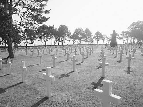
Among the notable people buried here are General Theodore Roosevelt Jr., his brother Quentin (who died in World War I but was moved here at the request of the family), and the Niland brothers (whose story inspired Saving Private Ryan). There are 33 pairs of brothers lying side by side, 1 father and son, 149 African Americans, 149 Jewish Americans, and 4 women. From the three generals buried here to the youngest casualty (a teen of just 17), each grave is of equal worth.
• To visit Omaha Beach, return up the long driveway to the roundabout (at the Overlord Museum) and follow signs to St-Laurent-sur-Mer (D-514). But first consider popping into the Overlord Museum.
Near the American Cemetery
Overlord Museum
While there are several museums more worthy of your sightseeing energy, you’ll drive right by this purpose-built warehouse filled with Normandy’s most impressive collection of WWII-era vehicles and more (the lineup outside the museum gives you an idea of what lies within). Offering a good balance of American, British, and German exhibits, the museum helps you better imagine the battles that took place here with sound effects and engaging displays. Its highlights include Germany’s 88mm antiaircraft and antitank gun (formidable and feared by the Allies), a rusted grappling hook from Pointe du Hoc, a strafed German Panther tank (the best tank of the Third Reich), a Panzer (the Panther’s predecessor), a Sherman tank, and a battlefield crane (recalling the on-the-go construction that took place in the field). You’ll also see a horse—a reminder that much of the German war machine was powered by horses—and a Jeep, one of 640,000 made for the war.
Cost and Hours: €10; daily June-Aug 9:30-19:00, off-season 10:00-18:30, Oct-March until 17:30, closed Jan; +33 2 31 22 00 55, www.overlordmuseum.com.
• As you continue west on D-514, just before St-Laurent-sur-Mer, be on the lookout for the well-signed...
La Ferme de la Sapinière Calvados Tasting
La Ferme de la Sapinière is a stony apple farm welcoming guests with lots of free tastes along with a few photos of this family’s (seven generations on this same farmstead) war experience. Drop-ins are welcome for tastings (say bonjour to ever-so-charming Laure and Véronique) or you can join a one-hour tour in English that explains the growing, pressing, and fermenting of apples in Normandy (followed by tasting).
Cost and Hours: Open daily for tasting 9:30-18:30 except closed Sun Oct-March; tour/tasting-€4.50, April-mid-Nov Mon-Sat at 14:30, no tours on Sun, wise to call first; +33 2 31 22 40 51, www.producteur-cidre.com. The farm is just off D-514 (Route de Port-en-Bessin) between the American Cemetery and St-Laurent-sur-Mer.
• From the farm, return to westbound D-514. At the next roundabout, follow signs on D-517 to Vierville s/Mer par la Côte to get to Omaha Beach.
Omaha Beach Sights from St-Laurent through Vierville
Omaha Beach has five ravines (or “draws”), which provided avenues from the beach past the bluff to the interior. These were the goal of the troops that day. You’ll drive down one (the Avenue de la Libération)—passing the small Omaha Beach Memorial Museum—to reach the beach and two commemorative statues. Then drive west along the beach to the National Guard Memorial before leaving the beach up a second ravine.
If it’s lunchtime, your best option, Restaurant L’Ephémère, awaits minutes away toward Pointe du Hoc. The recommended Hôtel la Sapinière and Hôtel du Casino also offer decent-value meals at their cafés. La Sapinière has better cuisine, but Casino has point-blank sea views (all open daily May-Sept, closed off-season).
Omaha Beach Memorial Museum (Musée Memorial d’Omaha Beach)
Skip the museum (for most visitors, it’s not worth the entry), but WWII junkies should make a quick stop in the parking lot. On display is a rusted metal obstacle called a “Czech hedgehog”—thousands of these were placed on the beaches by the Germans to stop and immobilize landing craft and foil the Allies’ advance. Find the green American 155mm “Long Tom” gun nearby, and keep it in mind for your stop at Pointe du Hoc (this artillery piece is similar in size to the German guns that US Army Rangers targeted at that site). The Sherman tank is one of the best examples of the type that landed on the D-Day beaches.
• You’ll hit the beach at a roundabout. Park your car for a look at the two memorials, and to take a good stroll on the beach. If parking is tight or you want a quieter beach experience, turn right and drive a kilometer along the road to find a small parking lot on the left (just before the Hôtel la Sapinière) with good beach access and a memorial to Charles Shay, one of two Native American combat medics to survive the war.
▲▲Omaha Beach Focal Point
Omaha was the most difficult of the D-Day beaches to assault. Nearly half of all D-Day casualties were suffered here, earning it the nickname “Bloody Omaha.”
Two American assault units landed on Omaha Beach—the 1st Infantry Division (the “Big Red One,” a veteran formation) and the 29th Infantry Division (a National Guard citizen army unit with little combat experience). For those troops, everything went wrong.
This four-mile-long beach is surrounded on three sides by cliffs, all heavily armed by Germans. The Allies’ preinvasion bombing was ineffective, and about 500 Germans manning 11 gun nests pummeled the beach all day. Thanks to the concave shape of the beach, German artillery was positioned to hit every landing ship. It was an amphitheater of death. If the tide is out, you’ll see little skinny lakes between the sandbars. These were blood red on D-Day.
Those who landed first and survived were pinned down, played dead, and came in with the tide over a period of four hours. Troops huddled against the beachhead and against each other for six to eight hours awaiting support—or death. But reinforcements kept coming, and thanks to navy ships that moved in dangerously close to shallow water, then turned broadside so they could fire at the Germans, the attack ended successfully. By the end of the day, 34,000 Americans had landed on the beach, and the Germans had been pushed back. In the next 34 days, these troops built 34 airfields. The final assault leading to Berlin was under way.
Memorial Statues
You’re at the center of Omaha Beach. While only Americans landed on this beach, the flags recognize eight nations that took part in the invasion. A striking modern metal statue (The Braves, 2004) rises from the waves in honor of the liberating forces and symbolizes the rise of freedom on the wings of hope. Next to that is a much older memorial from 1949. Built by thankful French, it was funded by selling scrap metal after the war and honors the two assaulting divisions, the 29th and 1st. You can read the motto of the 1st Division: “No mission too difficult. No sacrifice too great. Duty first.”
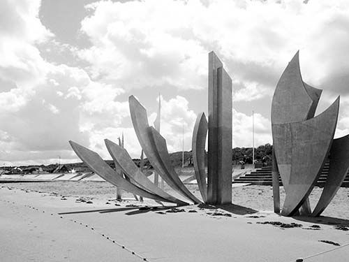
• Drive west from here along the beachfront, nicknamed “Golden Beach” before the war for its lovely sand.
Beachfront Drive
Drive at a snail’s pace. After about 300 yards, you’ll pass a small memorial on your left (easy to miss—look for a plaque about 3 feet high just before the white picket fence ends). This marks the site of the first temporary American cemetery (which was moved after about three days, as it provided a sad welcome to newly landed troops). While movie images give the impression that the D-Day beaches were wild, they were actually lined with humble beach hotels and vacation cottages much like those you see today.
• Drive until you see a wharf stretching out from the Hôtel du Casino, at the base of the next ravine, where you’ll find a couple of battlements and monuments. Park in the lot across from the hotel and walk toward the boxy gray monument by the flagpoles. Find the bronze statues of soldiers.
Bedford Boys and Artificial Harbor
These two bronze soldiers commemorate the so-called “Bedford Boys” and the little Virginia town of Bedford that contributed 35 men to the landing forces—19 were killed.
Look out to the ocean. It was here that the Americans assembled a floating bridge and artificial harbor (à la Arromanches; for a description, find the panel near the telescope). The harbor was under furious construction for 12 days before being destroyed by an unusually vicious June storm (the artificial port at Arromanches and a makeshift port at Utah Beach survived and were used until November 1944). The nearby pier offers good views—handy if the tide is in.
• Read the moving inscription in the boxy gray monument next to the statues, then walk down the steps in front of it.
National Guard Memorial
The 29th Infantry Division, a National Guard unit, was one of the American assault units that landed on Omaha Beach on D-Day. While well trained and disciplined, these troops were less experienced than the battle-tested 1st Division, their landing partners. A memorial to their sacrifices is built atop an 88mm German artillery casement.
Peer down through the cage into the gun station. Rather than being aimed out to sea, this gun was aimed at the beach. It could shoot all the way across the beach in two seconds at the rate of two well-aimed shots per minute. Its twin was several miles away at the opposite end of Omaha Beach. In 1944 the Germans built this gun station and hid it inside the facade of a fake beach hotel. Take a few steps toward the sea and look left to see a second gun casement that once held two 50mm guns that added to the Omaha Beach carnage.
• From here, drive uphill to return to coastal road D-514 at Vierville-Sur-Mer. When you reach D-514, turn right (west) and head toward Pointe du Hoc. Along the way, just past the turnoff for the hamlet of Englesqueville la Percée (D-125), you’ll have an opportunity to quench your thirst and satisfy your hunger.
Lebrec Calvados Tasting and Restaurant L’Ephémère
A 10th-century fortified farm on the left offers Calvados tastings (look for Cidre Bouché sign) and the recommended Restaurant L’Ephémère, your best Omaha Beach lunch or dinner option.
For a tasting, cross the drawbridge and park on the right. Ring the rope bell and meet charming owners Soizic and Bernard Lebrec (+33 9 60 38 60 17). They’re happy to offer a free three-part tasting: cider, Pommeau (a mix of apple juice and Calvados), and a six-year-old Calvados. Consider their enticing selection of drinkable souvenirs, and check out their maps marking where visitors have come from. Bernard likes to share his family’s D-Day scrapbook (his historic farm was requisitioned as a military base in 1944). Ask to see the farm’s own D-Day monument. Erected in September 1944—before the war was even over—it’s likely one of the earliest in France.
A recent and welcome addition to the farm, Restaurant L’Ephémère is run by Bernhard’s brother-in-law and is an excellent choice for lunch or dinner in this area. For details, see the listing under “Sleeping and Eating near Omaha Beach,” later.
• Rejoin D-514, and at the next roundabout, follow signs to our next stop, Pointe du Hoc.
▲▲▲Pointe du Hoc Ranger Monument
The intense bombing of the beaches by Allied forces is best understood at this bluff. This point of land was the Germans’ most heavily fortified position along the Utah and Omaha beaches. The cliffs are so severe here that the Germans turned their defenses around to face what they assumed would be an attack from inland. Yet US Army Rangers famously scaled the impossibly steep cliffs to disable the gun battery. Pointe du Hoc’s bomb-cratered, lunar-like landscape and remaining bunkers make it one of the most evocative of the D-Day sites.
Cost and Hours: Free, always open; visitors center open daily 9:00-18:00, Oct-March until 17:00, +33 2 31 51 62 00, www.abmc.gov/cemeteries-memorials. It’s off route D-514, 20 minutes west of the American Cemetery, in Cricqueville-en-Bessin.
Crowd Control: The sight is most crowded in the afternoons. Try to avoid 14:00-16:00 in summer. Make a point to remember where you parked, as the many small lots all look the same.
Visiting Pointe du Hoc
Two paths lead to the site, one from each end of the linear parking lots. Start at the visitors center and tour the site counterclockwise. Figure on walking about a level mile round-trip.
Visitors Center and Bluff: The visitors center has a slow-moving security line to enter and a must-see, seven-minute film explaining the daring Ranger mission through interviews with survivors (push the button on the brown sign to start it).
Exiting the center, follow a gravel path to the bluff with panels focusing on individual Rangers and their courage. You’ll pass through a hedgerow (think of the soldier’s challenge these hedgerows created as hiding Germans could surprise them at any point), then enter the open site. Immediately on your left find the raised concrete opening that’s as wide as a manhole cover and about six feet deep. This was a machine gun nest that had three soldiers crammed inside—a commander, a gunner, and a loader.
• From here, you’ll continue on fenced paths leading through the war-torn terrain.
Lunar Landscape: All these craters are the result of 10 kilotons of bombs—nearly the explosive power of the atomic bomb at Hiroshima—but dropped over seven weeks. This was a jumbo German gun battery, with more than a mile of tunnels connecting its battlements. Its six 155mm guns could fire as far as 13 miles—good enough to hit anything on Omaha or Utah beach. For the American D-Day landings to succeed, this nest had to be taken out. So the Allies pulverized it with bombs, starting in April 1944 and continuing until June 6—making this the most intensely bombarded of the D-Day targets. Even so, the heavily reinforced bunkers survived.
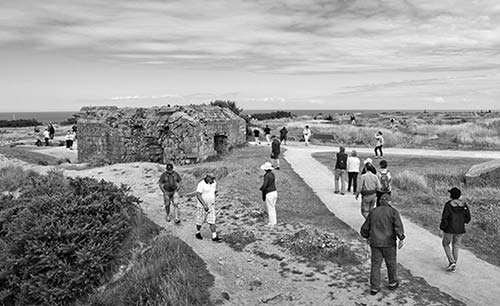
The battle-scarred German bunkers and the cratered landscape remain much as the Rangers left them. You can identify the gun placements by the stubby, circular, concrete walls, sometimes with the rusted remains of a gun support sticking out of the center. The guns sat in wide-open placements.
Viewing Platforms: Two bunkers are capped with viewing platforms and good information panels. Climb up top to appreciate the intensity of the blasts that made the craters and disabled phone lines—cutting communication between the command bunker and the guns to render them blind.
• Work your way to the bunker with the tall stone memorial at the cliff edge.
Dagger Memorial: The memorial represents the Ranger dagger used to help scale the cliffs. Here, it’s thrust into the command center of the battery. Exploring the heavily fortified interior of this observation bunker (officers’ quarters, enlisted quarters, and command room) with its charred ceiling and battered hardware, you can imagine the fury of the attack that finally took this station. The slit is only for observing. This bunker was the “eyes” of the guns—from here spotters directed the firing via hard-wired telephone, sending coordinates to the gunners at the six 155mm guns. The bronze plaque in the larger room honors the Rangers who did not return from this mission.
Walk down the steps to the front of the bunker for the greatest impact. Peer over the cliff and think about the 225 handpicked Rangers who attempted a castle-style assault on the gun battery (they landed on the beach down to the right). They used rocket-propelled grappling hooks connected to 150-foot ropes, and climbed ladders borrowed from London fire departments.
Timing was critical; the Rangers had just 30 minutes to get off the beach before the rising tide would overcome them. Fortunately, the soldiers surprised the Germans and climbed to the top in two hours—the Germans had prepared no defense for an attack up the cliffs. The most dangerous part of the Rangers’ mission occurred after reaching the top, when they faced an intense German counterattack. The Rangers used the bomb craters as foxholes until reinforcements arrived.
Then it was the Americans’ turn to be surprised. After taking control of the cliff top, the Rangers found that the guns had been moved—the Germans had put telegraph poles in their place as decoys. The Rangers eventually found the operational guns hidden a half-mile inland and destroyed them.
Three American presidents (Eisenhower in 1963, Reagan in 1984, and Clinton in 1994) have stood at this bunker to honor the heroics of those Rangers.
• Follow the path to the west end of the site and exit; it leads past a big French 155mm gun barrel from World War I. State-of-the-art in 1917, this gun was still formidable in World War II. Six of these were what Pointe du Hoc was all about.
Our tour of the American Omaha Beach sights is finished. To consider the other side of the conflict, visit the German Military Cemetery at La Cambe. To get there from Pointe du Hoc, follow D-514 west and turn off in Grandcamp following signs to La Cambe and Bayeux (D-199). Then follow signs marked Cimetière Militaire Allemand.
▲German Military Cemetery at La Cambe (Cimetière Militaire Allemand)
To appreciate German losses, visit this somber, thought-provoking final resting place of 21,000 German soldiers. Compared to the American Cemetery at St-Laurent, this site is all about humility. The cemetery was not inaugurated until 1961—it took that long to identify bodies and find next of kin.
Cost and Hours: Free, daily 9:00-19:00, Nov-March until 17:00, +33 2 31 22 70 76, www.lacambe.fr. Good WCs are in the back of the visitors center.
Getting There: La Cambe is 15 minutes south of Pointe du Hoc and 20 minutes west of Bayeux (from the autoroute, follow signs reading Cimetière Militaire Allemand).
Visiting the Cemetery: The largest of six German cemeteries in Normandy, it’s appropriately bleak, with two graves per simple marker and dark basalt crosses in groups of five scattered about. The tall circular mound in the middle—with a cross, topped by a grieving mother and father—covers the remains of about 300 mostly unknown soldiers. You can climb to the top for a different perspective over the cemetery.
Wandering among the tombstones, notice the ages of the soldiers who gave their lives for a cause some were too young to understand. “STRM” indicates storm trooper—the most ideologically motivated troops that bolstered the German army. “GEFR” and “OGEFR” are enlisted soldiers. About a fifth of the dead are unidentified, listed as “Ein Deutscher Soldat.” You’ll also notice many who died after the war ended—a reminder that over 5,000 German POWs perished in France clearing the minefields their comrades had planted.
A field hospital was sited in this area during the war, and originally American troops were buried here. After the war, those remains were moved to the current American Cemetery or returned to the US. A small visitors center—with a focus on building peace—has good information about the background of this war cemetery, a small display showing the German soldiers’ last letters home, and a case of their artifacts. Another display shows soldiers in a human light, telling us, “Every dead soldier has a right to a grave with his name. His personal life story keeps the memory of war, violence, and injustice awake.” Visiting here, you can imagine the complexity of dealing with this for today’s Germans.
Sleeping and Eating near Omaha Beach
With a car, you can sleep in the countryside, find better deals on accommodations, and wake up a stone’s throw from many landing sites. Besides these recommended spots, you’ll pass scads of good-value chambres d’hôtes as you prowl the D-Day beaches. Two of these places are a few minutes toward Bayeux on D-517 in the village of Formigny; the restaurant is between omaha Beach and Pointe du Hoc on D-514.
$$ Hôtel la Sapinière** is a fun find just a few steps from the beach at Vierville-sur-Mer. A grassy, beach-bungalow kind of place, it has 15 bright rooms, all with private patios, and a lighthearted restaurant/bar (family rooms, outside St-Laurent-sur-Mer 10 minutes west of the American Cemetery—take D-517 down to the beach, turn right and keep going to 100 Rue de la 2ème Division D’Infanterie US, for location see the “D-Day Beaches” map, +33 2 31 92 71 72, www.la-sapiniere.fr, sci-thierry@wanadoo.fr).
$$ Hôtel du Casino*** is a good place to experience Omaha Beach. This average-looking hotel has surprisingly comfortable rooms and an inexpensive café/bar down below. It stands alone overlooking the beach in Vierville-sur-Mer, between the American Cemetery and Pointe du Hoc. All rooms have views, but the best face the sea: Ask formal owner Madame Clémençon for a côté mer room (elevator, Rue de la Percée, for location see the “D-Day Beaches” map, +33 2 31 22 41 02, www.omaha-beach-hotel.biz, hotel-du-casino@orange.fr). Don’t confuse this with Hôtel du Casino in St-Valery-en-Caux.
$ La Ferme aux Chats, run by ever-so-charming Céline, sits on D-517 across from the church in the center of Formigny. There’s a nice lounge with a small kitchen at your disposal, and five clean, very comfortable modern rooms and a lush, park-like garden that you can get lost in (includes breakfast, for location see the “Omaha Beach Area” map, +33 2 31 51 00 88, www.lafermeauxchats.fr, info@fermeauxchats.fr).
At $ Ferme du Mouchel, animated Odile rents three colorful and good rooms with impeccable gardens in a lovely farm setting (complete with farm smells) in the village of Formigny (cash only, includes breakfast, 3-day minimum in summer, must confirm arrival time, +33 2 31 22 53 79, mobile +33 6 15 37 50 20, www.ferme-du-mouchel.com, odile.lenourichel@orange.fr). Follow the sign from the main road (D-517), then take the first left down Chemin du Russe and keep going (for location see the “Omaha Beach Area” map).
$$ Restaurant L’Ephémère is a laid-back, all outdoors, très French, well-run café-restaurant serving delicious meals, salads, or just drinks with a smile (May-Sept Tue-Sat lunch and dinner, Sun lunch only, closed Mon and off-season, at the Lebrec Cidre farm, Château d’Englesqueville la Percée, for location see the “Omaha Beach Area” map, +33 7 57 85 06 34, www.lephemere-restaurant.fr).
Utah Beach
Utah Beach, added late in the planning for D-Day, proved critical. This was where two US paratrooper units (the 82nd and the 101st Airborne Divisions) dropped behind enemy lines the night before the invasion, as dramatized in Band of Brothers and The Longest Day. It was essential for the invading forces to succeed here, then push up the peninsula (which had been intentionally flooded by the Nazis) to the port city of Cherbourg.
Utah Beach was taken in 45 minutes at the cost of 194 American lives. Many more paratroopers died (over 1,000) preparing the way for the actual beach landing. Fortunately for the Americans who stormed this beach, it was defended not by Germans but mostly by conscripted Czechs, Poles, and Russians who had little motivation for this fight.
While the brutality on this beach paled in comparison with the carnage on Omaha Beach, most of the paratroopers missed their targets—some landing in trees, others landing in water and drowning. The soldiers who landed at Utah faced a three-week battle before finally taking Cherbourg. Utah Beach was crucial to the Allies’ victory: A temporary harbor was established here, where over 800,000 Americans (and 220,000 vehicles) would land over a five-month period.
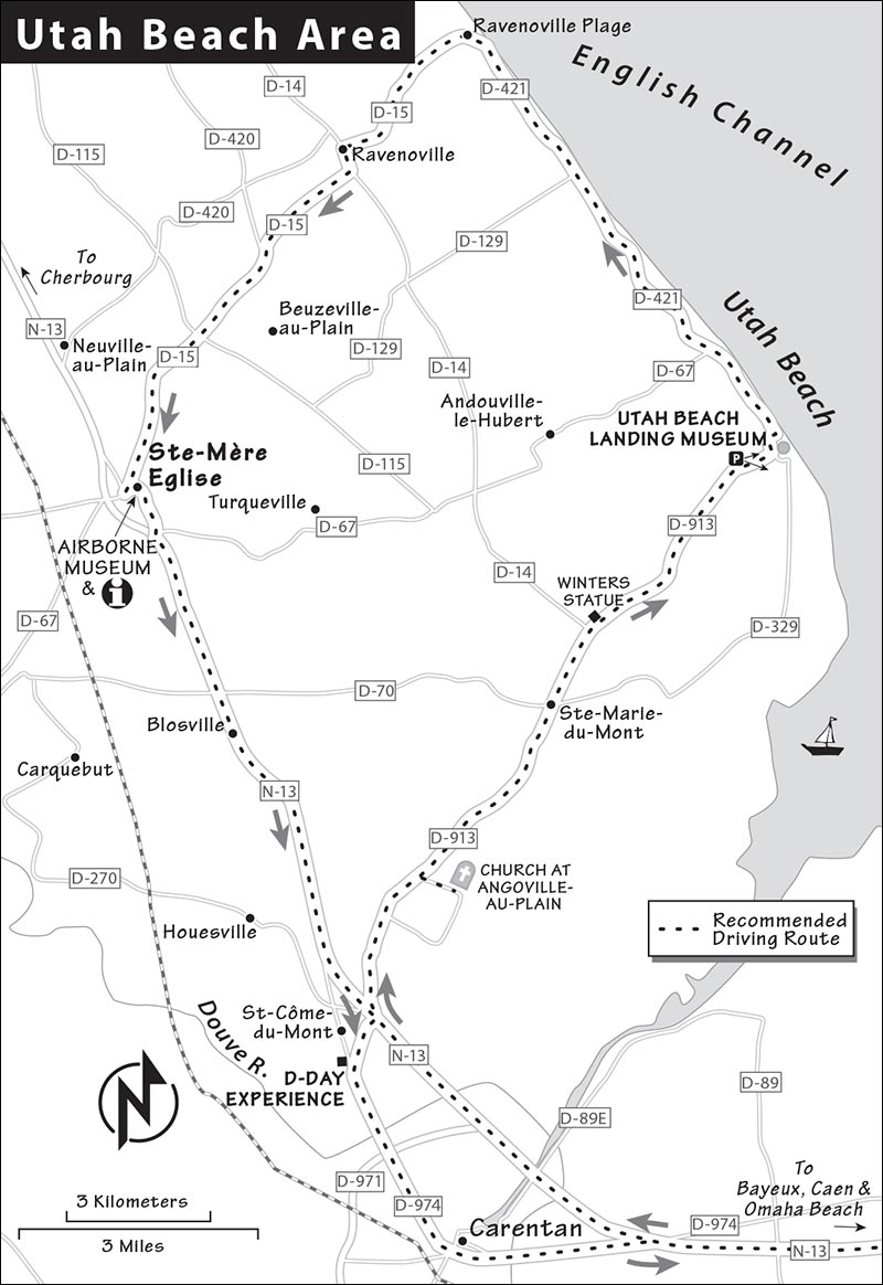
• These stops are listed in the order you’ll find them coming from Bayeux or Omaha Beach. For the first two, take the Utah Beach exit (D-913) from N-13 and turn right (see the “D-Day Beaches” map). Be prepared for a long day. Allow 45 minutes to reach Angoville-au-Plain if you come direct from Bayeux, an hour to drive between the Utah Beach sites, and 45 minutes back to Bayeux.
You’ll see signs for the Church at Angoville-au-Plain off D-913, a few minutes after leaving N-13.
Church at Angoville-au-Plain
At this simple Romanesque church, two young American medics—Kenneth Moore and Robert Wright—treated the wounded while battles raged only steps away. On June 6, American paratroopers landed around Angoville-au-Plain, a few miles inland of Utah Beach, and met fierce resistance from German forces. The two medics (who also parachuted in) set up shop in the small church and treated both American and German soldiers for 72 hours straight, saving many lives. German patrols entered the church on a few occasions. The medics insisted that the soldiers park their guns outside or leave the church—incredibly, they did. In an amazing coincidence, this 12th-century church is dedicated to two martyrs who were doctors.
Cost and Hours: Free, daily 9:00-18:00, 2 minutes off D-913 toward Utah Beach.
Visiting the Church: An informational display outside the church recounts the amazing story, and a memorial thanks the medics for their heroic service (reconnaissant means gratitude). Pass through the small cemetery and enter the church. Inside, several wooden pews toward the rear still have visible bloodstains. Find the new window that honors the American medics and a simpler one that honors the American Airborne’s Screaming Eagles paratroopers. A good brochure about the events here is available by the altar (€3).
After surviving the war, both Wright and Moore returned to the US and led full lives. Wright’s wish was to be buried here; you’ll find his grave in the cemetery by turning right from the church and keeping right until you see a square black headstone inscribed with “REW.”
• Back on D-913, as you continue toward the beach, you’ll see a statue on the left (look for flags) a few minutes after passing through Ste-Marie-du-Mont. This honors paratrooper Richard Winters, a hero of the 101st Airborne Division’s “Easy Company,” who landed near here. Winters was the leader of the company portrayed in Band of Brothers.
▲▲▲Utah Beach Landing Museum (Musée du Débarquement)
This is the best museum located on the D-Day beaches, and worth the 50-minute drive from Bayeux. For the Allied landings to succeed, a myriad of complex tasks had to be coordinated: Paratroopers had to be dropped inland, the resistance had to disable bridges and cut communications, bombers had to soften German defenses by delivering their payloads on target and on time, the infantry had to land safely on the beaches, and supplies had to follow the infantry closely. This thorough yet manageable museum pieces those many parts together in a series of fascinating exhibits and displays.
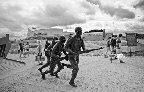
Cost and Hours: €8.50; daily June-Sept 9:30-19:00, Oct-Nov and Jan-May 10:00-18:00, closed Dec, last entry one hour before closing; +33 2 33 71 53 35, off D-913 at Plage de la Madeleine, www.utah-beach.com. Park in the “obligitaire” lot, then walk five minutes to reach the museum.
Film and Tours: Check for the next English video time when you pay (every 40 minutes). Guided tours of the museum and the beachfront are offered usually twice a day in high season (45-minute museum tour-€2.50, 90-minute tour including beach-€5, call ahead for times or ask when you arrive, tips are appropriate).
Visiting the Museum
Built around the remains of a concrete German bunker, the museum nestles in the sand dunes on Utah Beach with floors above and below beach level. Your visit follows a one-way route beginning with background about the American landings on Utah Beach (over 20,000 troops landed on the first day alone) and the German defense strategy (Rommel was in charge of maintaining the western end of Hitler’s Atlantic Wall). Don’t miss the 12-minute film, Victory in the Sand, which sets the stage.
Highlights of the museum are the displays of innovative invasion equipment with videos demonstrating how it all worked (most were built for civilian purposes and adapted to military use): the remote-controlled Goliath mining tank, the LVT-2 Water Buffalo and Duck amphibious vehicles, and the wooden Higgins landing craft. Next, see a fully restored B-26 bomber with its zebra stripes and 11 menacing machine guns—find the one at the rear. Without the B-26, many experts say the landings would not have been successful (the yellow bomb icons painted onto the cockpit indicate the number of missions a plane had flown).
After getting your mission briefing, head upstairs to a large, glassed-in room overlooking the beach. From here, you’ll peer over re-created German trenches and get a sense for what it must have been like to defend against such a massive and coordinated onslaught.
Outside the museum, find the beach access where Americans first broke through Hitler’s “Atlantic Wall.” Pile into the Higgins boat replica (this one is made of steel—those used in the landings were made from plywood) and tip your cap to Andrew Higgins, the inventor of this craft (read the panel by his statue). Hike up to the small bluff, which is lined with monuments to the branches of military service that participated in the fight. About 30 yards beyond, a gun sits atop a buried battlement, part of a vast underground network of German defenses. And all around are memorials and memories of battle frozen in time.
• For the 20-minute drive to our next stop, Ste-Mère Eglise, take the scenic D-421 route along the coast right from the museum, and follow brown signs inland to the town. Imagine this low-lying area of farmland flooded—and the challenge that would present for soldiers.
▲Ste-Mère Eglise
This celebrated village lies about eight miles west of Utah Beach and was the first village to be liberated by the Americans. The area around Ste-Mère Eglise was the center of action for American paratroopers, whose objective was to land behind enemy lines before dawn on D-Day and wreak havoc in support of the Americans landing at Utah Beach that day.
For The Longest Day movie buffs, Ste-Mère Eglise is a necessary pilgrimage. It was in and near this village that many paratroopers, facing terrible weather and heavy antiaircraft fire, landed off-target—and many landed in the town. American paratrooper Private John Steele dangled from the town’s church steeple for two hours (a parachute and mannequin have been installed on the steeple near where Steele became snagged). Though many paratroopers were killed in the first hours of the invasion, the Americans eventually overcame their poor start and managed to take the town. (Steele survived his ordeal by playing dead.) These troops who dropped (or glided) in behind enemy lines in the dark played a critical role in the success of the Utah Beach landings by securing roads and bridges.
Today, the village greets travelers with flag-draped streets (and plenty of pay parking). The 700-year-old medieval church on the town square now holds two contemporary stained-glass windows (enter the church through the side door that opens onto the square). The window in the back, made in 1984 for the 40th anniversary of the invasion, celebrates the heroism of the Allies. The window in the left transept, made in 1969 for the 25th anniversary, features St. Michael, patron saint of paratroopers (description in the small frame).
The TI on the square across from the church has loads of information (Mon-Sat 9:00-13:00 & 14:00-18:00, Sun 10:00-13:00; Oct-March closed Sun; 6 Rue Eisenhower, +33 2 33 21 00 33, www.ot-baieducotentin.fr).
Museums in and near Ste-Mère Eglise
▲▲Airborne Museum
This four-building site is dedicated to the daring aerial landings that took place here. In the Utah Beach sector alone, 23,000 men were dropped from planes or landed in gliders, as were thousands of vehicles and tons of supplies.
Cost and Hours: €10; daily May-Aug 9:00-19:00, April and Sept 9:30-18:30, shorter hours off-season and closed Jan; 14 Rue Eisenhower, +33 2 33 41 41 35, www.airborne-museum.org. Skip the free but useless HistoPad.
Visiting the Museum: Your visit to the museum unfolds across four buildings (allow a full hour and be aware that renovations may change the order of your visit).
The first building holds a Douglas C-47 plane that dropped paratroops and supplies. Here you’ll find a forest of mannequin soldiers, displays of their personal possessions and weapons, parachutes suspended from the ceiling, and a well-done movie recounting D-Day history with a focus on Utah Beach battles. Enter the briefing room to get the lowdown on your mission (through an effective hologram presentation), then climb the steps for a better perspective on the planes and to try on a parachute backpack.
A second structure, labeled Operation Neptune, puts you into the paratrooper’s experience starting with a night flight and jump, then tracks your progress on the ground past enemy fire using elaborate models and sound effects. Don’t miss the touching video just before the exit showing the valor of Gen. Theodore Roosevelt Jr. on D-Day.
Next enter a building holding a Waco glider, one of 104 such gliders flown across the channel at first light on D-Day to land supplies in fields to support the paratroopers (more would be used later). These gliders carried 4,000 men into Normandy and could normally be used only once. Feel the canvas fuselage and check out the bare-bones interior.
The fourth building houses a room filled with mannequin-paratroopers and a cushy theater showing a worthwhile 20-minute film about the airborne invasion.
• From Ste-Mère Eglise, head 10 minutes on N-13 (back toward Bayeux) to St-Côme-du-Mont.
▲D-Day Experience/Dead Man’s Corner
This unique museum is dedicated to the paratroopers of the 101st Airborne Division (a.k.a. the “Screaming Eagles”), the first to land in Normandy. The museum has three parts: the “Dead Man’s Corner” exhibit, which highlights the battles that raged around this vital location, the D-Day Experience section, and two superb 3-D IMAX films about the Battle of Normandy and Battle of Carentan; the first and more important film, narrated by Tom Brokaw, immerses you in the events surrounding the D-Day invasions (24 minutes for each film). The museum, a labor of love for the passionate owners, is crammed with artifacts, uniforms, and impressive re-created scenes. You’ll want a good two to three hours to do it all.
The highlight for many is the D-Day Experience with two creative exhibits designed to help you feel what it might have been like to be in the 101st. You’ll enter a briefing room for a 10-minute review of your mission by a hologram commander. Then you’ll climb into an authentic Douglas C-47 (built in 1943, it actually flew on D-Day), buckle in, survive a simulated flight through flak across the English Channel, and then crash-land before you can parachute out.
Cost and Hours: €9 for the films, €14 for flight simulator and museum, €20 for the whole enchilada; daily April-Sept 9:30-19:00, Oct-March 10:00-18:00; 2 Vierge de l’Amont (D-913), St-Côme-du-Mont, +33 2 33 23 61 95, www.dday-experience.com.
Canadian D-Day Sites
The Canadians’ assignment for the Normandy invasions was to work with British forces to take the city of Caen. They hoped to make quick work of Caen, then move inland. That didn’t happen. The Germans poured most of their reserves, including tanks, into the city and fought ferociously for a month. The Allies didn’t occupy Caen until August 1944.
Juno Beach Centre
Located on the beachfront in the Canadian sector, this facility—inaugurated in 2003—is dedicated to teaching travelers about the vital role Canadian forces played in the invasion, and about Canada in general. Canada declared war on Germany two years before the United States, a fact little recognized by most Americans today (after the US and Britain, Canada contributed the largest number of troops to D-Day—14,000). The Centre includes many thoughtful exhibits that bring to life Canada’s unique ties with Britain, the US, and France, and explains how the war front affected the home front in Canada.
Cost and Hours: €7.50, €12 with guided tour of Juno Beach—highly recommended; open daily April-Sept 9:30-19:00, Oct and March 10:00-18:00, Nov-Dec and Feb 10:00-17:00, closed Jan; +33 2 31 37 32 17, www.junobeach.org.
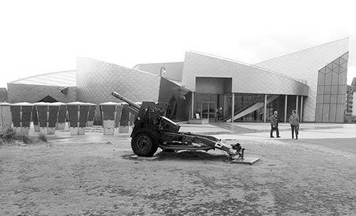
Tours: The best way to appreciate this sector of the D-Day beaches is to take a tour with one of the Centre’s capable Canadian guides, who will take you down into two bunkers and a tunnel of the German defense network (€6 for tour alone, 45 minutes; April-Oct generally at 10:30 and 14:30, July-Aug also at 11:30, 13:30, 14:30, and 16:30; verify times prior to your visit). If you can’t make a tour, ask for the brochure that gives a self-guided tour of the beaches.
Getting There: It’s in Courseulles-sur-Mer, about 15 minutes east of Arromanches off D-514. Approaching from Arromanches, as you enter the village of Grave-sur-Mer, watch for the easy-to-miss Juno Beach-Mémorial sign marking the turnoff on the left; you’ll drive the length of a sandy spit (passing a marina) to the end of the road at Voie des Français Libres, where you’ll find the parking lot.
Visiting the Juno Beach Centre: Your visit begins with a short film designed to get you inside the soldiers’ heads as their boats neared the shore. Then you’ll view informative exhibits about the various Canadian forces and their contributions to the invasion. You’ll learn about the campaigns that Canadian soldiers were most involved with (such as the disastrous raid on Dieppe) and understand the immense challenges they faced during and after the landings. A scrolling list honors the 45,000 Canadians who died in World War II, and a large hall highlights the vital roles women played in the war. Round out your visit with a powerful 12-minute film that captures Canada’s D-Day experience.
A temporary exhibit (€4, through at least 2024) about the failed 1942 Allied amphibious raid on the French port of Dieppe makes a terrific addition to the site. The display describes why this raid mattered and why it failed—and the lessons learned (which would prove invaluable in the planning of the D-Day invasions). The Dieppe raid is an important event to Canadians, as 5,000 of the 6,000 troops involved were Canadian and 85 percent of them did not return.
Take advantage of the center’s eager-to-help, red-shirted “student-guides” (young Canadians working a seven-month stint here). Ask about the bulky “kiosks” in front of the center and get their take on other D-Day sites.
Nearby: Between the main road and the Juno Beach Centre, you’ll spot a huge stainless-steel double cross (by a row of French flags). This is La Croix de Lorraine, marking the site where General de Gaulle returned to France (after four years of exile) on June 14, 1944. A small memorial just beyond is dedicated to the 16,000 Polish soldiers who fought in the Battle of Normandy.
Canadian Cemetery
This small, touching cemetery hides a few miles above the Juno Beach Centre. To me, it captures the understated nature of Canadians perfectly. Surrounded by pastoral farmland with distant views to the beaches, you’ll find 2,000 graves marked with maple leaves and the soldiers’ names and ages. Most fell in the first weeks of the D-Day assault. This cemetery is run and maintained by the Commonwealth War Graves Commission based in England.
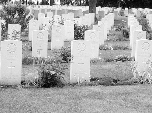
Getting There: From Courseulles-sur-Mer, follow signs to Caen on D-79. After a few kilometers, follow D-35 toward Reviers (and Bayeux). The cemetery is on Route de Reviers.
Caen Memorial Museum
Caen, the modern capital of lower Normandy, has the most thorough (and by far the priciest) WWII museum in France. Located at the site of an important German headquarters during World War II, its official name is Caen-Normandy Memorial: Center for History and Peace (Mémorial de Caen-Normandie: Cité de l’Histoire pour la Paix). With thorough coverage of the lead-up to World War II and of the war in both Europe and the Pacific, accounts of the Holocaust and Nazi-occupied France, the Cold War aftermath, and more, it effectively puts the Battle of Normandy into a broader context and is worth ▲▲▲ for those with sufficient time.
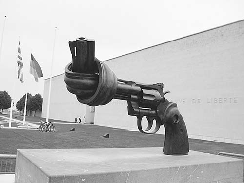
It’s like a history course that prepares you for the D-Day sites, but it’s a lot to take in with a single visit (tickets are valid 24 hours). If you have the time and attention span, it’s as good as it gets. If forced to choose, spend your time on the beaches and their smaller, more focused museums and sights.
GETTING THERE
By Car: From Bayeux, it’s a straight shot on N-13 to Caen (30 minutes). From Paris or Honfleur, follow the A-13 autoroute to Caen. When approaching Caen, take the Périphérique Nord (ring-road expressway) to sortie (exit) #7—the museum is a half-mile from here. Track Le Mémorial signs around umpteen roundabouts to the museum. When leaving the museum, follow Toutes Directions signs back to the ring road.
By Train or Bus: By train, Caen is two hours from Paris (12/day) and 20 minutes from Bayeux (20/day). The modern train station sits next to the gare routière, where buses from Honfleur arrive (2/day express or 7-12/day local). There’s no baggage storage at the station, though it is available (and free) at the museum.
Taxis usually wait in front of the train station and will get you to the museum in 10-15 minutes (about €20 one-way—more expensive on Sun). A tram-and-bus combination takes about 30 minutes (Mon-Sat only): Take the tram right in front of the train station (line A, direction: Campus 2, or line B, direction: St. Clair; buy ticket from machine and validate on tram and again on bus, good for entire trip). Get off at the third tram stop (Bernières), then transfer to frequent bus #2 going to La Folie (cross the street). For transit maps, see www.twisto.fr.
To return to the station, take bus #2—the shelter is across the street from the museum, on the right (museum has schedule, buy ticket from driver and validate); transfer to the tram at the Quatrans stop in downtown Caen. Either line A or line B will take you to the station (Gare SNCF stop).
ORIENTATION TO CAEN MEMORIAL MUSEUM
Cost and Hours: €20, ticket valid 24 hours, free for all veterans and kids under 10 (ask about good family rates), €23 combo-ticket with Arromanches 360° theater (see here). Open April-Sept daily 9:00-19:00; Oct-Dec and Feb-March Tue-Sun 9:30-18:00, closed Mon; closed most of Jan.
Information: The museum is located on Esplanade Général Eisenhower. For info, dial +33 2 31 06 06 44—as in June 6, 1944, www.memorial-caen.fr.
Planning Your Time: The museum is divided into two major wings: one devoted to the years before and during World War II, and the other to the Cold War years and later. If you won’t see other D-Day museums, focus on the WWII wing. If you’ve seen (or plan to visit) other D-Day museums, the most interesting and original section of this museum is its excellent coverage of the Cold War and the fall of the Berlin Wall. Allow at least two hours to see both wings.
Visitor Information: Excellent English descriptions are posted throughout. If you read every word, you’ll be here for days, so be selective and drill down on subjects that are most important to you. The €3 app adds insight but is not essential (kids’ version also available).
Tours: The museum runs small-group tours that combine entry to the museum with a 5-hour guided visit to key American sector sights (Pointe du Hoc, American Cemetery, and Omaha Beach; some with pickup at Caen train station; details on website).
Services: The museum provides free lockers that fit day packs but not large packs or suitcases. The large gift shop has plenty of books in English.
Eating: An all-day sandwich shop/café with reasonable prices sits above the entry area, and there’s a restaurant with a garden-side terrace (lunch only). Picnicking in the gardens is an option.
VISITING THE MUSEUM
Find Début de la Visite signs and begin your museum tour here with a downward-spiral stroll, tracing (almost psychoanalyzing) the path Europe and America followed from the end of World War I to the rise of fascism to World War II. Rooms are decorated to immerse you in the pre-WWII experience.
In the “World Before 1945” wing, big floor arrows lead past an incredible array of exhibits that deliver a thorough description of how World War II was fought—from General Charles de Gaulle’s London radio broadcasts to Hitler’s early missiles to wartime fashion to the D-Day landings. Videos, projections, maps, sound effects, and countless displays and re-creations relate the stories of the Battle of Britain, Vichy France, German death camps, the Battle of Stalingrad, the French Resistance, the war in the Pacific, and finally, liberation. Several powerful displays summarize the terrible human costs of World War II, from the pre-war destruction of Guernica in Spain to the death toll (21 million Russians died during the war; Germany lost 7 million; the US lost 300,000). A smaller, separate exhibit (on your way back up to the main hall) covers D-Day and the Battle of Normandy, though the battle is better covered at other D-Day museums described in this chapter.
Next, don’t miss the 25-minute film Saving Europe, an immersive and, at times, graphic black-and-white film covering the agonizing 100 days of the Battle of Normandy (runs every half-hour 10:00-18:00, English subtitles).
At this point, you’ve completed your WWII history course. Next comes the “World After 1945” wing, which effectively sets the scene for the Cold War and the psychological battles waged by the Soviet Union and the US for the hearts and minds of their people. You’ll experience 1950s US nostalgia contrasted with the grimmer realities of life in the USSR, and feel the threat of the arms race waged by the two powers (you’ll even see a real Soviet MiG 21 fighter jet and a Trabant car—the VW bug of the Eastern Bloc). A 20-minute, 360-degree film called Europe, Our History immerses you in pre- and post-WWII events and personalities (it’s fast-paced and left me wanting more substance). This wing culminates with an important display recounting the division of Berlin and its unification after the fall of the Wall.
Two more stops are outside the rear of the building. I’d skip the first, a re-creation of the former command bunker of German general Wilhelm Richter, with exhibits on the Nazi Atlantic Wall defense in Normandy. Instead, finish your tour with a walk through the US and Canadian Memorial Gardens (Vallée du Mémorial). On a visit here, I was bothered at first by the seemingly unaware laughing of lighthearted children, unable to appreciate the gravity of their surroundings. Then I read this inscription on the pavement: “From the heart of our land flows the blood of our youth, given to you in the name of freedom.” And their laughter made me happy.
TOWN OF CAEN
The old center of Caen is appealing and, with its château and abbeys, makes for a tempting visit. But I’d focus on Bayeux and the D-Day beaches. Bayeux or Arromanches—which are much smaller—make the best base for most D-Day sites, though train travelers with limited time might find urban Caen more practical.
A looming château, built by William the Conqueror in 1060, marks the city’s center. To the west, modern Rue St. Pierre is a popular shopping area and pedestrian zone. The more historic Vagueux quarter to the east has many restaurants and cafés.
Tourist Information: The TI is at 12 Place St. Pierre, 10 long blocks from the train station—take the tram to the St. Pierre stop (Mon-Sat 9:30-18:30, Sun until 13:30, closed Sun Oct-March, drivers follow Parking Château signs, +33 2 31 27 14 14, www.caenlamer-tourisme.fr).
Car Rental: If Caen is your first stop on a longer trip, or you’re here just for the D-Day beaches, this is the best place to rent a car. These companies are all within steps of the train station and are generally open Monday through Saturday 8:00-12:00 & 14:00-18:00, closed Sunday: Avis, 44 Place de la Gare, +33 820 61 16 81; Hertz, 24 Place de la Gare, +33 2 31 84 64 50; Sixt, 24 Place de la Gare, +33 1 70 97 61 11; and Europcar, 36 Place de la Gare, +33 9 77 40 32 74.
Mont St-Michel
For more than a thousand years, the distant silhouette of this island-abbey has sent pilgrims’ spirits soaring. Today, it does the same for tourists. Mont St-Michel, one of the top pilgrimage sites of Christendom through the ages, floats like a mirage on the horizon. For centuries devout Christians endeavored to make a great pilgrimage once in their lifetimes. If they couldn’t afford Rome, Jerusalem, or Santiago de Compostela, they came here, earning the same religious merits. Today, several million visitors—and a steady trickle of pilgrims—flood the single street of the tiny island each year. If this place seems built for tourism, in a sense it was. It has accommodated, fed, watered, and sold trinkets to generations of travelers visiting its towering abbey.
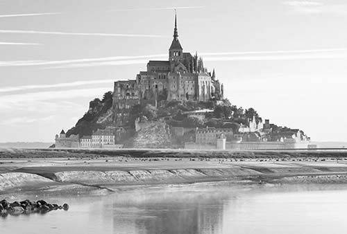
The tourist tide comes in each morning and recedes late each afternoon. To avoid crowds, arrive late in the afternoon, sleep on the island (best) or nearby on the mainland, and depart by late morning.
GETTING THERE
The easiest way to get to Mont St-Michel is by car, but train, bus, minivan, and bike options can work well too. With two exceptions—the direct bus from Ponterson or a bike—all of these leave you at the mainland parking lot, linked to the island by shuttles across a limited-access bridge (see “Arrival in Mont St-Michel,” later).
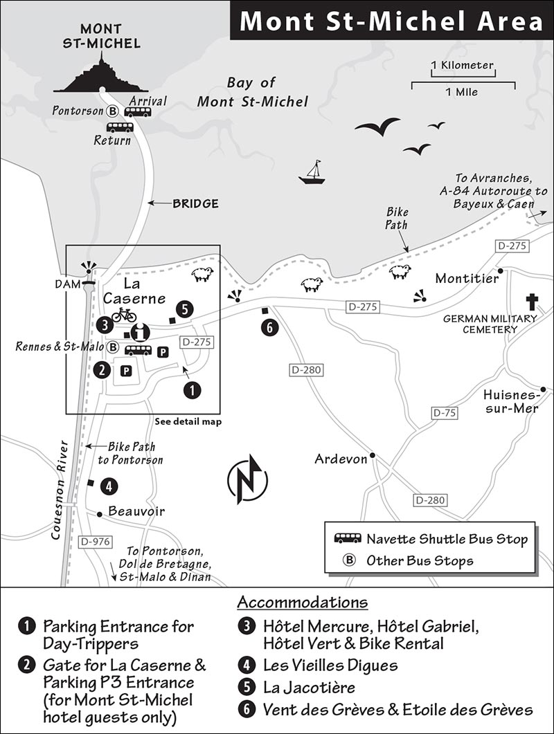
The TI websites listed later have good sections on arrival and are worth reviewing as you plan your trip.
By Car: Mont St-Michel is an easy 1.5-hour drive from Bayeux on the free and zippy A-84.
By Train and Bus from Paris, via Rennes: Most travelers take the high-speed train from Paris’ Gare Montparnasse to Rennes (3/day, 1.5 hours), where regional buses await to transfer you to Mont St-Michel (€15, not covered by rail pass, buy bus ticket online in advance to guarantee a seat, tickets also sold onboard, timed to meet train, 1 hour). Allow about 3 hours total (all explained in English at https://keolis-armor.com).
By Train and Bus or Taxi from Other Cities: The nearest train station is five miles away in Pontorson (called Pontorson/Mont St-Michel). But only a few trains stop here, and Sunday service is almost nonexistent (1 direct train/day from Paris, 2/day with transfer in Rennes, 4 hours; 2/day from Bayeux, 2 hours, faster by shuttle van). Trains are met by buses that take passengers right to the island (about €3, 10 buses/day July-Aug, 4/day Sept-June, 20 minutes). A taxi from Ponterson to the mainland parking lot runs about €25 (€35 after 19:00 and on weekends/holidays; +33 2 33 60 26 89, mobile +33 6 32 10 54 06).
By Bus from Paris: FlixBus runs buses to Mont St-Michel from Paris’ Gare de Bercy (4.5 hours). BlaBlaCar buses run from various stops in Paris to Beauvoir (5 hours), a 25-minute walk (or 10-minute bike ride) to the mainland parking lot (bike rental available in Beauvoir; see “Helpful Hints,” later). Neither bus is daily; see websites for schedules.
By Bus from St-Malo: In high season, a daily bus leaves St-Malo in the morning and returns late in the afternoon, allowing travelers a full day on the island (no bus on Sun off-season; see “Mont St-Michel Connections” at the end of this chapter).
By Minivan Shuttle from Bayeux: A shuttle van runs a daily round-trip to Mont St-Michel from a central point in Bayeux (see here).
By Bike: Biking has become a popular way to reach the island from nearby villages. Bike-only paths lead to the island abbey from all directions and avoid the shuttle-bus gauntlet.
Orientation to Mont St-Michel
Mont St-Michel is surrounded by a vast mudflat and connected to the mainland by a long, sleek bridge. The ancient Benedictine abbey towers above the small village, whose lone main drag (Grand Rue) is mobbed from 11:00 to at least 16:00 in most seasons. That single street is also home to the island’s hotels, restaurants, and trinkets. Though several tacky history-in-wax museums tempt visitors, the only worthwhile sights are the abbey at the summit and a ramble on the ramparts, which offers wonderful views and an escape from the tourist zone.
La Caserne, the modern “village” on the mainland side of the bridge, was built to accommodate cars and tour buses. It has huge parking lots, efficient shuttle buses running to and from the island every few minutes, and a handful of hotels and shops.
TOURIST INFORMATION
A helpful TI (with WCs) is in the mainland parking area, near the island shuttle stop (daily April-Sept 9:00-19:00, off-season 10:00-18:00, www.abbaye-mont-saint-michel.fr/en). A smaller TI on the island is at the post office (daily July-Aug 9:30-19:00, April-June and Sept until 18:30 and Sun until 18:00, shorter hours off-season; +33 2 33 60 14 30, www.ot-montsaintmichel.com). While either office can inform you about English tour times for the abbey, bus schedules, and tide tables (horaires des marées), the parking lot TI is less crowded.
In 1878, a causeway was built that allowed Mont St-Michel’s pilgrims to come and go regardless of the tide. The causeway increased the flow of visitors but blocked the flow of water around the island. The result: Much of the bay silted up, and Mont St-Michel was gradually becoming part of the mainland.
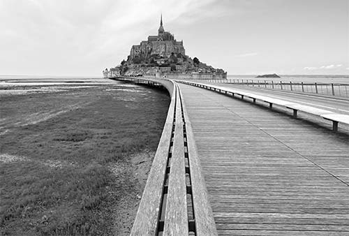
An ambitious and lengthy project to keep it an island was completed in 2015. The first phase was the construction of a dam (barrage) on the Couesnon River, which traps water at high tide and releases it at low tide, flushing the bay and forcing sediment out to the sea. The dam is an attraction in its own right, with info panels and great views of the abbey from its picnic-friendly wood benches. Mudflat parking lots at the foot of the island were then removed and a remote mainland parking lot was built, with shuttle buses ferrying visitors to the island.
Finally, workers tore down the old causeway and replaced it with the artistically swooping bridge you see today. The bridge allows water to flow freely around Mont St-Michel, preserving its island character. Those wanting to experience Mont St-Michel at its natural best should plan their trip to coincide with high tide (see www.ot-montsaintmichel.com for tide tables).
ARRIVAL IN MONT ST-MICHEL
For a run-down of your options for linking to Mont St-Michel, see “Getting to Mont St-Michel,” earlier.
Prepare for lots of walking, as the island—a small mountain capped by an abbey—is entirely traffic-free. Whether arriving by car, bus, taxi, or minivan, you’ll end up in the mainland parking lot, where you can either walk or take a shuttle to the island. Bikers have the option of pedaling across the bridge.
By Car: Day-trippers are directed to a sea of parking (remember your parking-area number). Expect parking jams in high season between 10:00 and noon. To avoid extra walking, take your parking ticket with you and pay at the machines near the parking lot TI (€20-25/24 hours—no reentry, parking +33 2 14 13 20 15). Parking is free if you arrive after 18:30 and leave before 01:00 that night.
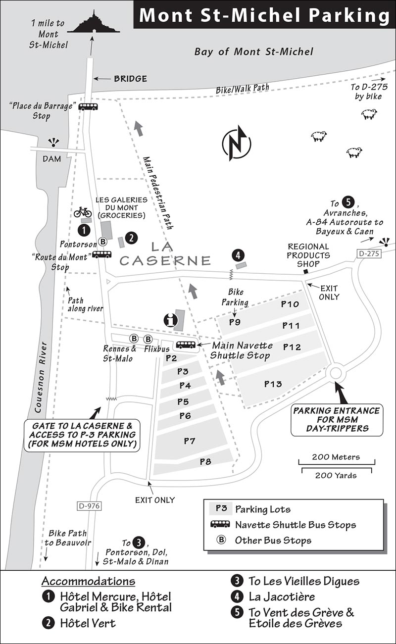
If you’re staying overnight at a hotel on the island or in La Caserne, you’ll receive a parking-gate code from your hotel (ending with “V”). As you approach the parking areas from Bayeux, don’t enter the parking lot at the main entry. Instead, follow wheelchair and bus icon signs until you come to a gate. Those staying on the island turn right here and follow signs for Parking P3 (the parking is close to the shuttle bus). Those staying in La Caserne enter their code and continue straight at the gate, then drive right to their hotel (€10 gate fee). Coming from Pontorson, you’ll reach the wheelchair and bus icons leading to the gate before the main parking entry.
By Bus, Taxi, or Minivan: These all drop you very near the La Caserne village shuttle bus stop (see next).
Getting from the Parking Lot or La Caserne to the Island: You can either walk (50 level and mostly scenic minutes from the farthest parking lot, 35 minutes from La Caserne) or pile onto the free shuttle bus (runs every five minutes from 7:30-24:00, 12-minute trip). The shuttle makes four stops: at the parking-lot TI, in La Caserne village (in front of the Les Galeries du Mont St-Michel grocery), near the dam at the start of the bridge, and at the island end of the bridge, about 200 yards from the island itself. The return shuttle stop is about a hundred yards farther from the island (where the benches start). Most stops are unsigned—sleek wood benches identify the stops. Buses are often crammed. If it’s warm, prepare for a hot (if mercifully short) ride. Bikers can ride across the bridge and leave bikes near the island’s left entrance (70 spaces). Additional bike racks are in the mainland parking lot (P-9) and along the walking/bike path (near the dam).
HELPFUL HINTS
Tides: The tides here rise above 50 feet—the largest and most dangerous in Europe. High tides (grandes marées) lap against the island door, where you should find tide tables posted (also posted at parking-lot visitors center and the island TI). If you plan to explore the mudflats, it’s essential to be aware of the tides—and be prepared for muddy feet.
Baggage Check: There is no bag check available.
ATM: You’ll find one on the island just outside the TI and post office.
Bike Rentals: Bike in Baie, in the nearby town of Beauvoir, has what you need from standard to e-bikes and good information on bike paths (www.bikinbaie.com, contact@bikinbaie.com). Abicylette Voyages works with the recommended Hôtel Gabriel in La Caserne to make bikes available there (+33 2 30 96 49 54, www.abicyclette-voyages.com).
Taxi: Dial +33 2 33 60 26 89 or mobile +33 6 32 10 54 06.
Guided Abbey Tours: Between the information in this chapter and the tours (and audio or multimedia guide) available at the abbey, a private guide is not necessary.
Guided Mud Walks: The TI can refer you to companies that run inexpensive guided walks across the bay (with some English).
Crowd-Beating Tips: If you’re staying overnight, arrive after 16:00 and leave by 11:00 to avoid the worst crowds. You can bypass the human traffic jam on the island’s main street by following this book’s suggested walking routes (under “Sights in Mont St-Michel”). If you’re here from mid-July through August, consider touring the abbey after dinner (it’s open from 21:00 to midnight).
Best Light and Views: Mont St-Michel faces southwest, making morning light along the sleek bridge eye-popping. Early risers win with the best light and the fewest tourists.
After dark, the island lights make a pretty sight. Views from the ramparts are sublime. Exit the island and walk out on the bridge a few hundred yards for evening views.
Sights in Mont St-Michel
The Bay of Mont St-Michel
Since the sixth century, the vast Bay of Mont St-Michel has attracted hermit-monks in search of solitude. The word “hermit” comes from an ancient Greek word meaning “person of the desert.” The next best thing to a desert in this part of Europe was the sea. Imagine the desert this bay provided as the first monk climbed the rock to get close to God. Add to that the mythic tide, which sends the surf speeding eight miles in and out. Long before the original causeway was built, pilgrims would approach the island across the mudflat, aware that the tide swept in “at the speed of a galloping horse” (well, maybe a trotting horse—12 mph, or about 18 feet per second at top speed).
Quicksand was another peril. A short stroll onto the sticky sand helps you imagine how easy it would be to get stuck as the tide rolled in. The greater danger for adventurers today is the thoroughly disorienting fog and the fact that the sea can encircle unwary hikers. (Bring a mobile phone, and if you’re stuck, dial 112.) Braving these devilish risks for centuries, pilgrims kept their eyes on the spire crowned by their protector, St. Michael, and eventually reached their spiritual goal.
▲▲Mudflat Stroll Around Mont St-Michel
To resurrect that Mont St-Michel dreamscape, it’s possible to walk out on the mudflats that surround the island. At low tide, it’s reasonably dry and an unforgettable experience. But it can be hazardous, so don’t go alone, don’t stray far, and be sure to double-check the tides—or consider a guided walk (details at the TI). You’ll walk on mucky mud and sink in to above your ankles, so wear shorts and go barefoot. Remember the scene from the Bayeux Tapestry where Harold rescues the Normans from the quicksand? It happened in this bay.
Village Walk Up to the Abbey
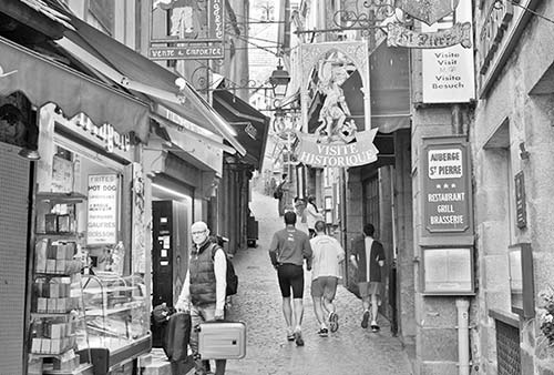
The island’s main street (Grand Rue) is grotesquely touristy. It is some consolation to remember that, even in the Middle Ages, this was a commercial gauntlet, with stalls selling souvenir medallions, candles, and fast food. With only 20 full-time residents (not counting a handful of monks and nuns at the abbey), the village lives solely for tourists.
To enjoy a nice, less-crowded walk, veer left just before the island’s main entry gate and walk under the stone arch of the freestanding stone building. Follow the cobbled ramp up to the abbey. This is also the easiest route up, thanks to the long ramps, which help you avoid most stairs. To trace the route, see the “Mont St-Michel” map, earlier.
If you opt to follow the direct route up through the village on Grand Rue, don’t miss the following stops:
Restaurant la Mère Poulard: Before the drawbridge, on your left, peek through the door of Restaurant la Mère Poulard. The original Madame Poulard (the maid of an abbey architect who married the village baker) made quick and tasty omelets here. These were popular with pilgrims who, back before there was a causeway or bridge, needed a quick meal before they set out to beat the tide. The omelets are still a hit with tourists—even at rip-off prices. Pop in for a minute just to enjoy the show as old-time-costumed cooks beat eggs. (When it comes to the temptation of an omelet on this island, I’d make like a good pilgrim and fast.)
King’s Gate: During the Middle Ages, Mont St-Michel was both a fortress and a place of worship. The abbot was a feudal landlord with economic, political, and religious power. Mont St-Michel was the abbot’s castle as well as a pilgrimage destination. Entering the town, you’ll pass two fortified gates before reaching the actual village gate, the King’s Gate, with its Hollywood-style drawbridge and portcullis. The old door has a tiny door within it, complete with a guard’s barred window (open it). The other gates you passed were added for extra defensive credit. Imagine breaching the first gate and being surrounded by defensive troops. The highest tides bring saltwater inside the lowest gate.
Main Street Tourist Gauntlet: Stepping through the King’s Gate, you enter the old town commercial center. Look back at the City Hall (flying the French flag, directly over the King’s Gate). Climb a few steps and notice the fine half-timbered 15th-century house above on the right. (To skirt the main street crowds, stairs lead from here to the ramparts and on to the abbey—see “Ramparts” under the Abbey listing, later.) Once upon a time this entire lane was lined with fine half-timbered buildings with a commotion of signs hanging above the cobbles. After many fires, the wooden buildings were replaced by stone. As you climb, you’ll see stone arches and half-timbered facades that pilgrims also passed by, five centuries ago.
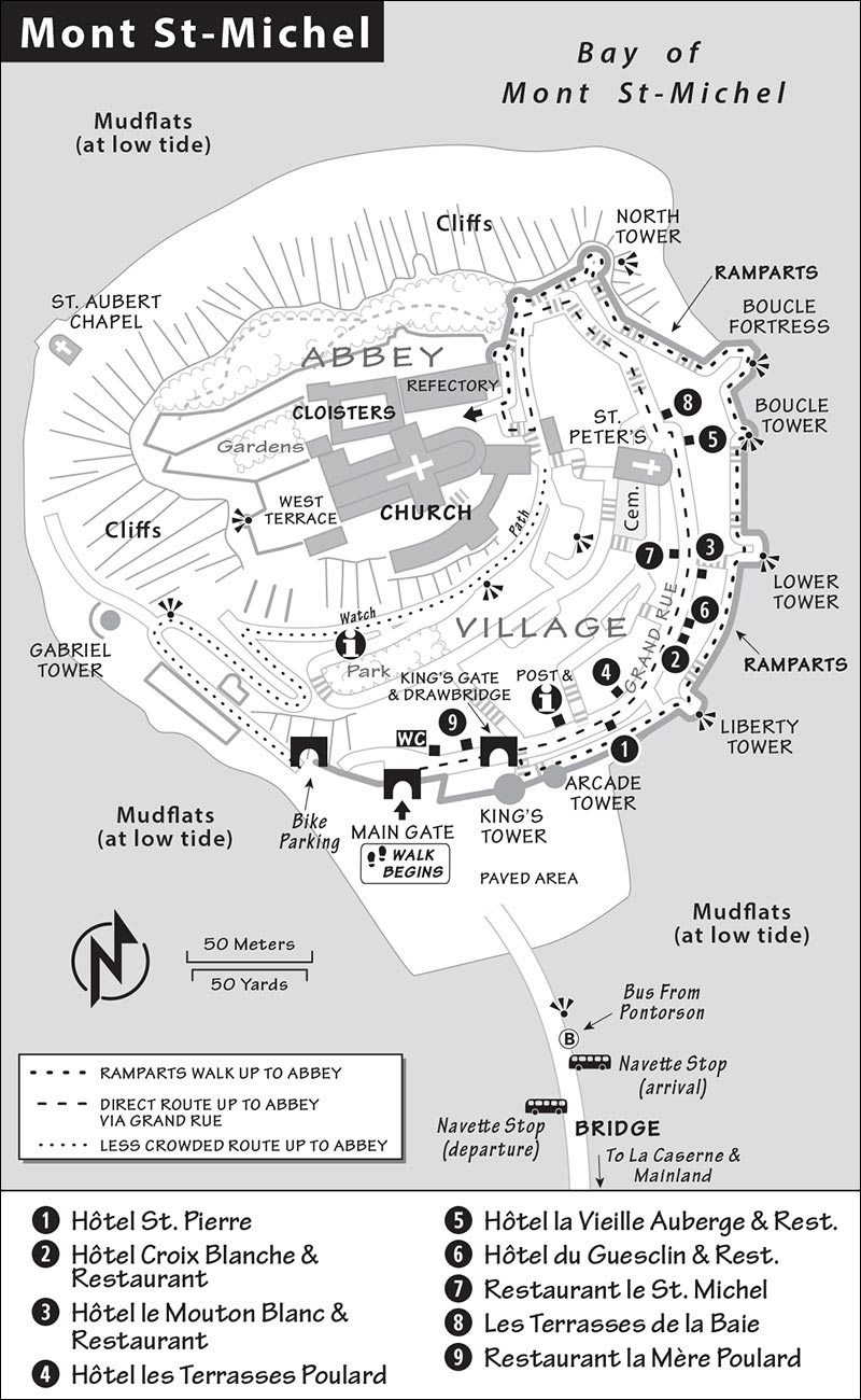
St. Peter’s Church (Eglise St-Pierre): At the top of the commercial stretch (on the left) is St. Peter’s Church. A statue of Joan of Arc (from 1909, when she became a saint) greets you at the door. She’s here because of her association with St. Michael, whose voice inspired her to rally the French against the English. St. Peter’s feels alive (giving a sense of what today’s barren abbey church might once have felt like). The church is dedicated to St. Peter, patron saint of fishermen, who would have been particularly beloved by the island’s parishioners. Just left of the entry is the town’s only surviving 15th-century stained-glass window. In the far-left rear of the church (past its granite foundation) find the dark 1772 painting of pilgrims crossing the mudflat under the protection of St. Michael, who seems to be surfing on a devil’s face over a big black cloud. To the right of the main altar lies the headless tomb of a 15th-century noblewoman (notice the empty pillow). During the Revolution heads were lopped off statues like this one, as France’s 99 percent rose up against their 1 percent in 1789. From the center of the altar area, the fine carvings on the lectern and tall chairs are the work of prisoners held here during the Revolution. The church offers several Masses (daily at 11:00 and special services for pilgrims).
Pilgrims’ Stairs to the Abbey: Approaching the abbey staircase, you’ll pass a hostel for pilgrims on the right (Maison du Pélerin, dark-red doors). As you climb the monumental stairway to reach the abbey, notice the fortified gate and ramparts necessary to guard the church entry back in the 14th century. Today the abbey, run by just a handful of monks and nuns, welcomes the public.
▲▲▲Abbey of Mont St-Michel
Mont St-Michel has been an important pilgrimage center since AD 708, when the bishop of Avranches heard the voice of Archangel Michael saying, “Build here and build high.” Michael reassured the bishop, “If you build it...they will come.” Today’s abbey is built on the remains of a Romanesque church, which stands on the remains of a Carolingian church. St. Michael, whose gilded statue decorates the top of the spire, was the patron saint of many French kings, making this a favored site for French royalty through the ages. St. Michael was particularly popular in Counter-Reformation times, as the Church employed his warlike image in the fight against Protestant heresy.
This abbey has 1,200 years of history, though much of its story was lost when its archives were taken to St-Lô for safety during World War II—only to be destroyed during the D-Day fighting. As you climb the stairs, imagine the centuries of pilgrims and monks who have worn down the edges of these same stone steps. Don’t expect well-furnished rooms; those monks lived simple lives with few comforts.
Cost and Hours: €11, daily 9:00-19:00, Sept-April 9:30-18:00; €15 for evening admission early July-Aug Mon-Sat 21:00-24:00; closed Dec 25, Jan 1, May 1, and one day during music festival in late Sept or early Oct; last entry one hour before closing, allow 20 minutes on foot uphill from the island TI, www.abbaye-mont-saint-michel.fr. Mass is held Tue-Sat at 12:00 and Sun at 11:15 (www.abbaye-montsaintmichel.com).
Advance Tickets: Consider purchasing timed-entry tickets for weekends and any day from May through September. Tickets are available online up to a month in advance, though I’ve never had trouble buying tickets once there.
When to Go: To avoid crowds, arrive before 10:00 or after 16:00 (the place gets really busy by 11:00). From mid-July through August, consider an evening visit (see “Cost and Hours,” above). You’ll enjoy the same access with mood-lighting effects (bordering on cheesy) and no crowds (daytime tickets aren’t valid for reentry). The last shuttle bus leaves the island for the mainland parking lot at midnight.
Information and Tours: There’s lots of information posted throughout the abbey—if you read French. If you don’t and want the full story, rent the audioguide (€3), or take an English-language guided tour (free but tip requested, 2-4 tours/day Mon-Fri, 1-2 hours, book online or at TI). These tours can be good, but usually come with big crowds. You can start a tour, then decide if it works for you—but I’d skip it, and follow my tour, next.
 Self-Guided Tour: Your visit is a one-way route, so there’s no way to get lost—just follow the crowds. You’ll climb to the ticket office, then climb some more. Along that final stony staircase, you’ll pass banners describing key dates in the abbey’s history. Monks and nuns (who lived in separate quarters on the left) would draw water from a cistern from the big faucets on the right. At the top (just past the WC) is a small view terrace, with a much better one just around the corner.
You’ve climbed the mount. Stop and look up to the church and spot golden St. Michael crowning the spire. The rounded tower houses a spiral stairway…to heaven.
• Pass through a small corner of the church and exit to the big terrace, then walk to the wall at the far end, and face the church.
West Terrace: In 1776, a fire destroyed the west end of the church, leaving this unplanned grand view terrace. The original extent of the church is outlined with short walls (look for a drawing on the green-topped block). In the paving stones, notice the stonecutter numbers, which are generally not exposed—a reminder that stonecutters were paid by the piece. The buildings of Mont St-Michel are made of granite stones quarried from the Isles of Chausey (visible on a clear day, 20 miles away). Tidal power was ingeniously harnessed to load, unload, and even transport the stones, as barges hitched a ride with each incoming tide.
As you survey the Bay of Mont St-Michel, notice the polder land—farmland reclaimed by Normans in the 19th century with the help of Dutch engineers. The lines of trees mark strips of land regained in the process. Today, the salt-loving plants covering this land are grazed by sheep whose salty meat is considered a local treat. You’re standing 240 feet above sea level.
The bay stretches from Normandy (on the right as you look to the sea) to Brittany (on the left). The Couesnon River to the left marks the historic border between the two lands. Brittany and Normandy have long vied for Mont St-Michel. In fact, the river used to pass Mont St-Michel on the other side, making the abbey part of Brittany. Today, it’s just barely—but definitively—on Norman soil. The new dam across this river was built in 2010. Central to the dam is a system of locking gates that retain water upriver during high tide and release it six hours later, in effect flushing the bay and returning sediment to a mudflat at low tide (see the “An Island Again” sidebar, earlier).
• Now enter the...
Abbey Church: Find a pew near the altar, under the little statue of the Archangel Michael (with the spear to defeat dragons and evil, and the scales to evaluate your soul). Monks built the church on the tip of this rock to be as close to heaven as possible. The downside: There wasn’t enough level ground to support a sizable abbey and church. The solution: Four immense crypts were built under the church to create a platform to support each of its wings. While most of the church is Romanesque (see the 11th-century round arches behind you), the light-filled apse behind the altar was built later, when Gothic arches were the rage. In 1421, the crypt that supported the apse collapsed, taking that end of the church with it. None of the original windows survive (victims of fires, storms, lightning, and the Revolution).
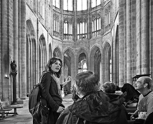
Directly in front of the altar, look for the glass-covered manhole (you’ll see it again later from another angle). To the right of the altar you might find a dazzling display from the late 1800s—including a curved sword, symbolic collar, and stunning crown—all meant for St. Michael. Take a spin around the apse and find the suspended pirate-looking ship.
• Follow Suite de la Visite signs to enter the...
Cloisters: A standard abbey feature, this peaceful zone connected various rooms. Here monks could meditate, read the Bible, and tend their gardens (growing food and herbs for medicine). The great view window is enjoyable today (what’s the tide doing?) but was not part of the original design. The more secluded a monk could be, the closer he was to God. Notice how the columns are staggered. This efficient design allowed the cloisters to be supported with less building material (a top priority, given the difficulty of transporting stone this high up). Carvings above the columns feature various plants and heighten the cloister’s Garden of Eden ambience. The few statues of various saints, carved among some columns, were defaced—literally—by French revolutionaries.
• Continue on to the...
Refectory: At its peak, the abbey was home to about 50 monks. This was the dining hall where they consumed both food and the word of God in near silence as one monk read in a monotone from the Bible during meals (pulpit on the right near the far end). The monks gathered as a family here in one undivided space under one big arch (an impressive engineering feat in its day). The abbot ate at the head table; guests sat at the table below the cross. The clever columns are thin but very deep, allowing maximum light and solid support. From 966 until 2001, this was a Benedictine abbey. In 2001, the last three Benedictine monks checked out, and a new order of monks from Paris took over.
• Stairs lead down one flight to handy WCs and a...
Stone Relief of St. Michael: This romanticized scene (carved in 1860) depicts the legend of Mont St-Michel: The archangel Michael wanted to commemorate a hard-fought victory over the devil with the construction of a monumental abbey on a nearby island. He sent his message to the bishop of Avranches—St. Aubert—who saw Michael twice in his dreams. But the bishop didn’t trust his dreams until the third time, when Michael drove his thumb into the bishop’s head, leaving a mark that he could not ignore. Notice the urgent gesture of Michael’s hand and arm as the saint points to the uninhabited mount. The bishop finally got the message, and the first chapel was consecrated in 709.
• Continue down the stairs another flight to the...
Guests’ Hall: St. Benedict wrote that guests should be welcomed according to their status. That meant that when kings (or other VIPs) visited, they were wined and dined without a hint of monastic austerity. This room once exploded in color, with gold stars on a blue sky across the ceiling. (This room’s decoration was said to be the model for Paris’ Sainte-Chapelle.) The floor was composed of glazed red-and-green tiles. The entire space was bathed in glorious sunlight, made divine as it passed through a filter of stained glass. The big double fireplace, kept out of sight by hanging tapestries, served as a kitchen—walk under it, imagine an entire wild boar on a spit, and see the light.
• Hike up the stairs to the...
Hall of the Grand Pillars: Perched on a pointy rock, the huge abbey church had four sturdy crypts like this to prop it up. You’re standing under the Gothic portion of the abbey church—this was the crypt that collapsed in 1421. Notice the immensity of the columns (15 feet around) in the new crypt, rebuilt with a determination not to let it fall again. Look up in the center to see the round hole in the ceiling and recognize it as the glass “manhole cover” from the church altar above.
• To see what kind of crypt collapsed, continue on to the...
Crypt of St. Martin: This simple 11th-century vault, one of the oldest on the mount, is textbook Romanesque. It has minimal openings, since the walls needed to be solid and fat to support the buildings above. As you leave, notice the thickness of the walls.
• Walking on you’ll come to the…
Ossuary (identifiable by its big treadwheel): The monks celebrated death as well as life. This part of the abbey housed the hospital, morgue, and ossuary. Because the abbey graveyard was small, it was routinely emptied, and the bones were stacked here.
During the Revolution, monasticism was abolished. Church property was taken by the secular government, and from 1793 to 1863, Mont St-Michel was used as an Alcatraz-type prison. Its first inmates were 300 priests who refused to renounce their vows. (Victor Hugo complained that using such a place as a prison was like keeping a toad in a reliquary.) The big treadwheel from 1820—the kind that did heavy lifting for big building projects throughout the Middle Ages—is from the decades when the abbey was a prison. Teams of six prisoners marched two abreast in the wheel, hamster-style, powering two-ton loads of stone and supplies up Mont St-Michel. Spin the rollers of the sled next to the wheel.
From here, you’ll pass through a chapel (with a rare fragment of a 13th-century fresco above), walk up the Romanesque-arched North-South Stairs, pass through the Promenade of the Monks (appreciate the fine medieval stonework), go under more Gothic vaults, and finally descend into the vast...
Scriptorium Hall (a.k.a. Knights Hall): This important room is where monks decorated illuminated manuscripts and transcribed texts. It faces north so its big windows would let in lots of flat, indirect light, the preference of artists throughout time. You’ll then spiral down to the gift shop, exiting out the back door.
• You’ll emerge into the rear garden. Find an open spot and look back from where you just came and up at a miracle (merveille) of medieval engineering.
The “Merveille”: This was an immense building project—a marvel back in 1220. Three levels of buildings were created: the lower floor for storage, the middle floor for work and study, and the top floor for meditation (in the cloister, open to the heavens). It was a medieval skyscraper. The vision was even grander—the place where you’re standing was to be built up in similar fashion to support an expansion of the church. But the money ran out, and the project was abandoned.
• Exiting the abbey, you’ll pop out midway on the steps you climbed to get here. You could descend here straight into tourist hell. But for a little rampart romance, go down only until you find the short stairway on the left. Climb up the dozen steps and circle right, following a well-fortified outer rampart with a few awe-inspiring viewpoints before heading back down to the King’s Gate and the bridge. (From near the high point, try to spot the former schoolhouse—operational until 1972—with its school bell, small playground, and tree.)
Ramparts: Mont St-Michel is ringed by a marvelous example of 15th-century fortifications. They were built to defend against a new weapon: the cannon. They were low, rather than tall—to make a smaller target—and connected by protected passageways, which enabled soldiers to zip quickly to whichever zone was under attack. The five-sided Boucle Tower (1481) was crafted with no blind angles, so defenders could protect it and the nearby walls in all directions. And though the English conquered all of Normandy in the early 15th century, they never took this well-fortified island. Because of its stubborn success against the English in the Hundred Years’ War, Mont St-Michel became a symbol of French national identity.
NEAR MONT ST-MICHEL
German Military Cemetery (Cimetière Militaire Allemand)
Located three miles from Mont St-Michel, near tiny Huisnes-sur-Mer, this somber cemetery-mortuary houses the remains of 12,000 German WWII soldiers brought to this location from all over France. The stone blocks on the steps up indicate the regions in France from where they came. From the upstairs lookout, take in the sensational views over Mont St-Michel. The cemetery is well signed east of Mont St-Michel (off D-275 at 3 Rue du Mont de Huisnes).
Sleeping in Mont St-Michel
Sleep on or near the island so that you can visit Mont St-Michel early and late. What matters is being here before or after the crush of tourists. Sleeping on the island—inside the walls—is a memorable experience for medieval romantics who don’t mind small overpriced rooms of average quality and baggage hassles. To reach a room on the island, you’ll need to carry your bags 15 minutes, sometimes uphill, from the navette (shuttle) stop. Take only what you need for one night in a smaller bag, but don’t leave any luggage visible in your car.
Hotels and chambres d’hôtes near the island are a better value (if less romantic). Those listed are within walking distance of the free and frequent shuttle to the island.
ON THE ISLAND
Because most visitors day-trip here, finding a room is generally no problem, though some hotels pad their profits by requesting that guests buy dinner from their restaurant. Higher-priced rooms generally have bay views.
The following hotels, all on Grand Rue, are listed in order of altitude from lowest to highest.
$$$ Hôtel St. Pierre*** and Hôtel Croix Blanche*** sit side by side and share owners and a reception desk (at St. Pierre). Each provides comfortable, if a bit tired, rooms at inflated prices, some with good views. Croix Blanche rooms come with showers only; St. Pierre has only tub-showers (family rooms, lower rates at Hôtel Croix Blanche, +33 2 33 60 14 03, www.auberge-saint-pierre.fr, contact@auberge-saint-pierre.fr, www.hotel-la-croix-blanche.com).
$$$ Hôtel le Mouton Blanc*** and Hôtel les Terraces Poulard*** have the same owners and contact info. Les Terraces’ rooms are the closest (and priciest) ones I list to the island entry, are contemporary in style, and are the most comfortable. Mouton Blanc, a bit higher along the main drag, has 15 rooms split between two buildings. Rooms in the main building are best with wood beams and traditional décor; those in the annex are more modern (reception for both is at Hôtel les Terrasses Poulard, left on the stairs after TI/post office, +33 2 33 89 02 02, https://lemontsaintmichel.info).
$$ Hôtel la Vieille Auberge** is a small place with good rooms at decent prices (pricier but worthwhile view room with deck, www.lavieilleauberge-montsaintmichel.com, contact@lavieilleauberge-montsaintmichel.com, reception is at Hôtel St. Pierre, listed above).
$ Hôtel du Guesclin** has the cheapest and best-value rooms I list on the island and is the only family-run hotel left there. Rooms have simple, traditional decor and provide adequate comfort (+33 2 33 60 14 10, www.hotel-mont-saintmichel.fr, hotel.duguesclin@orange.fr).
ON THE MAINLAND
Modern hotels with easy parking and quick shuttle-bus access gather in La Caserne near the bridge to the island. All hotel addresses are listed as Route du Mont Saint-Michel and share the same website (Hotels.Le-Mont-Saint-Michel.com).
$$ Hôtel Mercure*** rents the best rooms in La Caserne and has air-con and pleasant public spaces (+33 2 33 60 14 18, H1263@accor.com).
$$ Hôtel Gabriel*** has 45 modern rooms, with flashy colors and OK rates (+33 2 33 60 14 13, hotelgabriel@le-mont-saint-michel.com).
$ Hôtel Vert** provides 54 motel-esque, comfortable rooms at fair rates (family rooms, +33 2 33 60 09 33, stmichel@le-mont-saint-michel.com).
CHAMBRES D’HOTES
These places are all good values and walkable to the shuttle buses.
$ Les Vieilles Digues, where charming, English-speaking Danielle will pamper you, is toward Pontorson on the main road (on the left if you’re coming from Mont St-Michel). It has a lovely garden and six spotless and homey rooms, all with showers (but no Mont St-Michel views). Ground-floor rooms have private patios on the garden (includes good breakfast, easy parking, 68 Route du Mont St-Michel, +33 2 33 58 55 30, www.lesvieillesdigues.com, les.vieillesdigues@yahoo.fr). A pedestrian path offers a level walk along the Couesnon River to the shuttle buses a half-mile away.
$ La Jacotière is closest to Mont St-Michel and within very easy walking distance of the regional bus stop and island shuttle buses (allowing you to avoid all parking fees). Welcoming Véronique offers six comfortable rooms and views of the island from the cool backyard garden (book this one well ahead; studio with great view from private patio, family rooms, includes breakfast, +33 2 33 60 22 94, www.lajacotiere.fr, lajacotiere.montstmichel@gmail.com). Drivers coming from Bayeux should keep right well before the main parking lot entry: As the road bends to the left away from the bay, stay straight and look for a regional products store standing alone on the right. Follow the small service lane in front of the store signed, sauf véhicule autorisé—La Jacotière is the next building. Those coming from Pontorson should pass the main parking lot entrance then turn left near the regional products store.
¢ Vent des Grèves and Etoile des Grèves are about a mile down D-275 from Mont St-Michel (green sign; if arriving from the north, they’re just after Auberge de la Baie) and walking distance to the shuttle buses (along a busy road). Gentle neighbors Estelle and Stéphane offer comfortable rooms in two separate buildings for a steal. The main building has five bright, big, and modern rooms with good views of Mont St-Michel and a common deck with tables to let you soak it all in (includes breakfast, 27 Rue de la Côte, +33 2 33 48 28 89, www.ventdesgreves.fr, ventdesgreves@orange.fr). The smaller building has four sharper rooms in an apartment-like setting with a full living room (includes breakfast, 27 Rue de la Côte, +33 7 71 75 27 79, www.etoiledesgreves.com, etoiledesgreves@gmail.com).
NEARBY, IN PONTORSON
Budget travelers could consider sleeping five miles away in Pontorson (with a good selection of cheap accommodations and restaurants). From nearby Beauvoir, you can rent a bike for the easy and scenic pedal on a separated path to Mont St-Michel (see “Helpful Hints,” earlier). These two places are a five-minute walk from the train station.
$$ Hôtel Montgomery Best Western*** is a good, Old World place with comfortable rooms, a nice garden terrace, a bar, and appealing lounges (13 Rue de Couesnon, www.hotel-montgomery.com, info@hotel-montgomery.com).
$ Mont B&B is a four-room place wrapped in stone that feels more like a small hotel with B&B rates. It offers pleasant gardens to lounge in (34 Boulevard Clemenceau, +33 7 67 26 67 94, www.montbandb.com, contact@montbandb.com).
Eating in Mont St-Michel
Puffy omelets (omelette montoise, or omelette tradition) are Mont St-Michel’s specialty. Also look for mussels, seafood platters, and locally raised lamb pré-salé (a saltwater-grass diet gives the meat a unique taste, but beware of impostor lamb from New Zealand—ask where your dinner was raised). Muscadet wine (dry, white, and cheap) from the western Loire Valley is made nearby and goes well with most regional dishes.
The cuisine served at most restaurants is low quality, similar, and geared to tourists (with menus from €20 to €35, cheap crêpes, and full à la carte choices). Pick a restaurant for its view. Window-shop the places that face the bay from the ramparts walk (several access points—one is across from the post office at the bottom of the village) and arrive early to land a view table. Unless noted, the following restaurants are open daily for lunch and dinner.
$$ Hôtel du Guesclin is the top place for a traditional meal, with white tablecloths and beautiful views of the bay from its inside-only tables (closed Thu, book a window table in advance; see details under “Sleeping in Mont St-Michel—On the Island,” earlier).
$ Restaurant le St. Michel is lighthearted, reasonable, and family-friendly with decent omelets, mussels, salads, and pasta (open daily for lunch, open for dinner July-Aug, closed Thu-Fri off-season, test its toilet in the rock, across from Hôtel le Mouton Blanc, +33 2 33 60 14 37).
$$ Le Mouton Blanc is a stylish three-story restaurant. It’s worth considering for its upstairs terrace, which offers the best outside table views up to the abbey (when their umbrellas don’t block it). $$ La Vieille Auberge has a broad terrace with the next-best views to the abbey. $$ La Croix Blanche owns a small deck with abbey views and window-front tables with bay views, and $$ Les Terrasses de la Baie, at the top of the street, has indoor views to the bay.
Groceries: In La Caserne, Les Galeries du Mont St-Michel is stocked with souvenirs and barely enough groceries to make a basic picnic (daily 9:00-20:00; see the “Mont St-Michel Parking” map).
Picnics: This is the romantic’s choice. The small lanes above the main street hide scenic picnic spots, such as the small park at the base of the ancient treadwheel ramp to the upper abbey. You’ll catch late sun by following the ramp that leads you through the gendarmerie and down behind the island (on the left as you face the main entry to the island). Sandwiches, pizza by the slice, salads, and drinks are all available to go at shops (open until 19:00) along the main drag.
Mont St-Michel Connections
BY TRAIN, BUS, OR TAXI
Bus and train service to and from Mont St-Michel can be a challenge. You may find that you’re forced to arrive and depart early or late—leaving you with too much or too little time on the island. Understand all of your options. For more details, see “Getting to Mont St-Michel,” earlier.
From Mont St-Michel by Train: Regional buses (see next) connect the mainland parking lot to Rennes, where you can catch a high-speed train to Paris (3/day, 1.5 hours). You can also take a short bus or taxi ride to Pontorson and connect to slower trains to Paris (3/day, 1 direct, others transfer in Rennes, 4 hours) or Bayeux (2/day, 2 hours).
From Mont St-Michel by Bus: Keolis operates regional buses from the mainland parking lot to Rennes (3/day direct, 1 hour) and St-Malo (1/day, 1 hour, daily July-Aug, no bus on Sun off-season; bus leaves St-Malo at 9:15, leaves Mont St-Michel at 15:15, allowing a full day on the island). Bus info: +33 2 99 26 16 00, https://keolis-armor.com.
FlixBus runs direct service from Mont St-Michel to Paris’ Gare de Bercy several times a week.
From Mont St-Michel by Taxi: Taxis are more expensive but can be helpful if trains and buses don’t cooperate—but reserve ahead, as many taxis might be booked for longer rides. If you’re going to Brittany, figure €110 from Mont St-Michel to St-Malo or Dinan (50 percent more on Sun and at night).
ROUTE TIPS FOR DRIVERS
From Mont St-Michel to St-Malo, Brittany: The direct (and free) freeway route takes 40 minutes. For a scenic drive into Brittany, take the following route: Head to Pontorson, follow D-19 signs to St-Malo, then look for St. Malo par la Côte and join D-797, which leads along La Route de la Baie to D-155 and on to the oyster capital of Cancale. In Cancale, keep tracking St. Malo par la Côte and Route de la Baie signs. You’ll be routed through the town’s port (good lunch stop), then emerge on D-201. Take time to savor Pointe du Grouin, then continue west on D-201 as it hugs the coast to St-Malo (see here).